Forum Index > Trip Reports > russian butte 6-12-10
 Reply to topic
Previous :: Next Topic
Author Message
b00
Member
Member


Joined: 29 Sep 2003
Posts: 1144 | TRs | Pics
b00
Member
PostTue Jun 15, 2010 5:44 pm 
russian butte 6-12-10
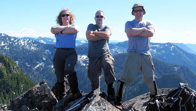
three_cossacks_on_russian_butte
i can't count the number of times i have looked over at, talked and thought about russian butte. i figured i would eventually find a way to get to the top and pretty much assummed it would be with the beste man, fastfeet jt, jb, the med, t-man, iron and whichever of our buddies we could get(trick) into joining. unfortunately fastfeet is dealing with plantar fasciitis. the beste man is trying to do easier trips more appropriate to a septuagenarian( i think he is afraid another day hike like either our witches tower or buckhorn/boulder ridge pk trips last summer, would do him in:>) he really did not seem that tired on those trips. when i called jb he just said yes without much debate. i guess he figured i would need adult supervision. unfortunately jb's fiance got a little too wild, sprained her ankle, so jb had to cancel off the trip to attend to her. iron was planning a great overnight trip to image lake, a trip he had been jonesing for a long time. reading his trip report tells me he was feeling the same way about image lake as i was for russian butte: "so... heading into this trip, i started getting the 'crap! i'm really really excited about this trip' feeling. you know, the kind where you're at work and it's pretty much the only thing you can think about and your stomach churns a little like when you have butterflies when just starting to date someone" since gabriel had done the route, i called him to ask him about the summit block. i knew he would not sandbag me. he was down in arizona hiking, but was nice enough to call me back. he let me know the steep heather on the ne side was steep, but not scary. thank you! gabriel had done an approach from the south, up past granite lakes and onto the south ridge. i wanted to come in from the north using the old pratt river trail. i had wanted to go this way, but had some really bad info that there was a problem with getting to the pratt river trail and i am sure you still do have a problem, if you go the wrong way. i luckily found a report from someone who had done that portion of the trail (https://www.nwhikers.net/forums/viewtopic.php?t=7983536). i know dave, i was fortunate enough to do lewis pk with him so i knew his info would be more than right on. also while researching the trip, i found out my buddy mike c had made an attempt via the pratt. i called mike and although he was really busy, he called me back and gave me all the info he could. preparation is great, but luck trumps preparation as you will see as the story unfolds. the beste man had talked this trip over many times with superwoman and neher-man. when i emailed neher-man, he about had a heart attack from excitement. superwoman had just had her climbing plans trashed by a terrible avy forecast and was so happy to get a chance to climb a peak for the beste man. it was now up to only the neher-man and superwoman to provide the adult supervision. would they be up to the task? the plan was to start out at the middle fork trailhead, head down to the pratt river trail, head up the pratt river trail to ~1600', drop down and cross the pratt(this is where mike c had said it was pretty easy to cross), pick russian butte's e ridge, then do a rising nw traverse and pick our way up to the summit. i was estimating about 16mi. the neher-man suggested we meet earlier than our 6:30am rendevouz. i said no, we should be able to do it in the 14hrs of daylight left. famous last words. i am one of the most lucky people around. i tell my friends this, but they often don't believe me. well it happened again. my biggest worry for this whole trip, was getting across the pratt. the creeks were all swollen and the pratt would be too. within minutes of starting sw down the middlefork trail we ran into a guy with 4 dogs. we found out he, jan g, too was headed up russian butte. he and i started talking and found we had a number of peaks we had done in common. not only that, but he had done russian butte over ten times and from many different approaches and as luck would have it, he was doing the same approach as we were. better yet, he had found a great crossing down much lower on the river than i expected to cross. i visited with him and we walked together down the middle fork trail to the pratt trail and then we all headed up the pratt trail to the sign pointing to the big trees. jan led us over to the pratt giant, big tree, and then headed off-trail leading us down to the pratt where he showed us the crossing, gave us some route advice and left us to set up his camp. the crossing was fantastic. one huge easy log led to an island in the pratt
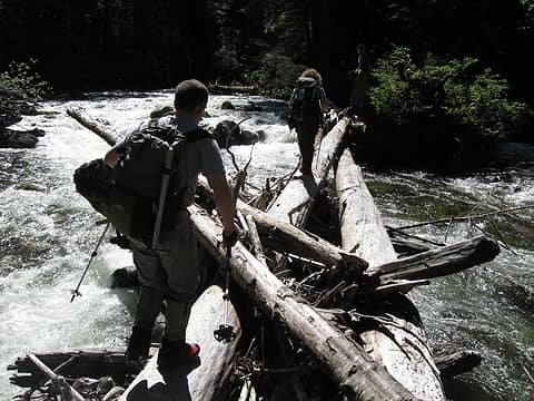
this huge easy log led from an island in the pratt to its west bank
and another big easy log led us from the island over to west shore of the pratt. taking jan's advice, we headed up the pratt, staying close to the river (but not too close), avoiding the temptation to ascend too early, found some old roads that paralleled the pratt (without ascending too early). we had spent a lot more time, even with jan's pratt crossing, to get to this point than we had expected. we knew we have to do everything right to get back before dark. but we all knew that our turnaround time would be when we summited. this crew was experienced and understood the situation. we continued past the main stream crossing and onward until we could get see we could gain russian butte's east ridge. we then headed up the ridge. not minutes after starting our ascent of the ridge, who do you think we see? if you knew how big and remote this area was, you would understand the coincidence. it was jan. he then led us up the very nice and not too brushy ridge. by now it was 2:30 and we all knew that summiting and getting back to the cars before dark was not in the cards. we continued on the forested ridge until we ran out of trees and into brush where he took us climber's left and up until we reached a talus field. we ascended the talus field as it jogged a little right and then worked back left. we exited the talus and ascended steeply to the ridge. we moved along the ridge to where it met the main mountain. there we found a snowmelt stream to fill water. it was here jan discovered one of his dogs was missing. he then tied up two of his remaining dogs and took one of them along with us. we then did a traverse climber's right and ever so slightly uphill to get around the base of some cliffs and then headed up westerly the very easy snow slopes/gulley that led us to within a couple hundred feet of the summit on the summit's ne side. jan then showed us a weakness in the cliffs that mostly connected by snow. there was a 10' section with no snow that was steep, wet, slippery, but had some vegitation to grab. it was tricky but doable. 50' below the summit there was also a short section, without snow, that was tricky that led up to the final ridge(we were able to avoid that section on descent as i found a route, that jan had never done, walking down the north ridge 40ft until we could easily regain the snow).
this should be called jan's russian butte :>:)
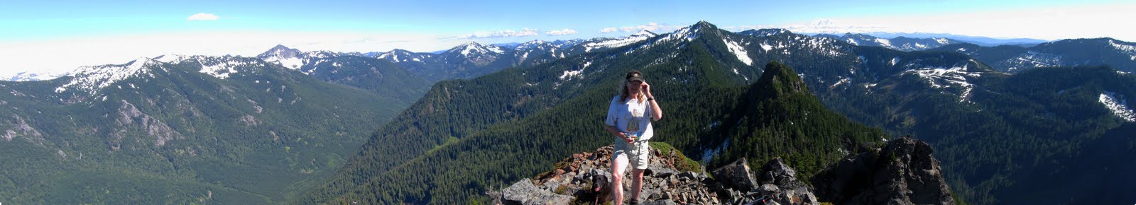
this should be called jan's russian butte :>)
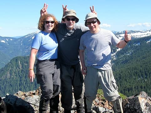
up on the summit of russian butte i put up a new register next to the old mason jar register. we put the beste man's name in first. after we got back and told him about this, the beste man did not like the fact that we wrote his name in there without him climbing it. so for the record, the beste man did not climb it, his friends did it for him. we quickly dropped our packs, took some hurried pictures, drank some water and i scouted out for a different descent route.
IMG_4269.JPG
IMG_4269.JPG
i knew we did not have time to waste, so i did not get a chance for lunch. it was now past 4:30 and we needed to get down and find the logs and get across the pratt before dark. this would be no easy task. we were all a little worried about jan's missing dog. good fortune smiled and he was back at the stream waiting with the other two dogs looking totally worn out. this was a tough situation. jan had a camp waiting at the pratt so he had more time, but getting a worn out dog down would be no easy task. we had a lot farther to go and little time to do it in. if jan would have asked for our help, i would have stayed as i am sure my friends would have too. but fortunately for us, he did not ask, so we headed down as quick as we safely could. we later learned he needed to leave the dog up there, go back to camp that night and come back up and retrieve him in the morning. we made really good time down the ridge, but light was becoming less and less our friend. it was not until 9:00 that we crossed the logs over the pratt.
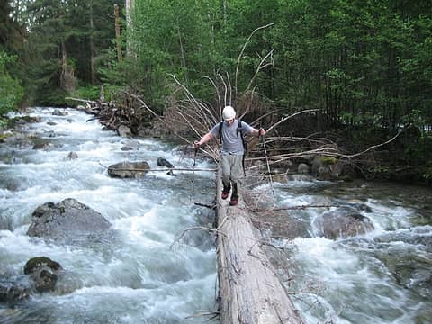
crossing the pratt on the big log
sunset hit and we were not back to any trail yet. time stood still. both our newer gps units were having trouble getting info on this valley floor. we were flying by instruments and the instruments were not working. we stumbled our way by hook and crook back to the pratt giant. we then stuggled with following the trail back to the pratt river trail. after finally getting on the pratt river trail we moved slowly by headlamp along the middle fork trail. we spent probably an hour looking for the rainy creek log crossing. the trail that was easy and obvious by day was not so by headlamp. i got everyone to sit down, relax, drink some water, eat and rest. we determined our probable location, determined where we thought the log crossing should be, took out the compass and bingo, we figured out where the trail was hiding and then found the crossing and continued back to the car. a few extra details: we found plenty of water all the way up to and following the pratt. once we reached started ascending from the pratt valley we did not find any until some snow melt creeks up high. i would not count on these once the snow is gone. also the brush was not as bad as i expected, except where we lost our way in the dark. most of this trip was off-trail with very little underbrush. still, we all left pretty scratched up. no real rock scrambling was needed. route finding was the crux and the three of us were all actively involved.
both neher-man and superwoman said it was the trip of the decade. all i can say is, i am glad it did not take a decade. thanks a bunch for another great day in the mountains and thanks even more to jan g without whose help we probably would never had made it on our first try :>) references: all the russian butte tr's on nwhikers(thanks guys!), http://www.yellowleaf.org/scramble/g/r/2005-07-01--02-The-Butte.html, mike c, gabriel, dave's pratt river giant tr: https://www.nwhikers.net/forums/viewtopic.php?t=7983536 equipment: ice axe, helmet, gps, brought crampons but did not use stats: leave car 7:49am on summit 4:22pm leave summit 4:38pm arrive back to car 2:31am car to summit 8:33 on summit 0:16 summit to car: 9:53 total time: 18:42 ~21.5mi, ~6700' gain (according to the gps - including ups, downs, routefinding, etc...)
on the bridge over the middle fork minutes from the car :>:)
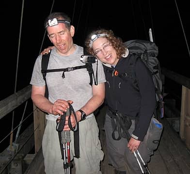
on the bridge over the middle fork minutes from the car :>)
ps - hey brad, pleased to meet you at the trailhead. your website http://middleforkgiants.com/ is excellent!

Back to top Reply to topic Reply with quote Send private message
Spotly
Member
Member


Joined: 06 Jan 2004
Posts: 3723 | TRs | Pics
Location: Spokane Valley
Spotly
Member
PostTue Jun 15, 2010 6:18 pm 
Excellent read. Sounds like an adventure to remember. The pic near the trailhead says it all about what a grunt it must have been smile.gif

Back to top Reply to topic Reply with quote Send private message
b00
Member
Member


Joined: 29 Sep 2003
Posts: 1144 | TRs | Pics
b00
Member
PostTue Jun 15, 2010 6:22 pm 
iron wrote:
glad to see you followed rule number 1, and number 3 for good measure.
rule number 1 - be cool rule number 2 - look good rule number 3 - the summit isn't everything, it is the only thing rule number 4 - always remember, safety fourth! thanks iron, you know we always follow the rules! :>)
iron wrote:
have you closed out this quad yet?
not yet :>)

Back to top Reply to topic Reply with quote Send private message
huron
Member
Member


Joined: 13 Sep 2004
Posts: 1035 | TRs | Pics
huron
Member
PostTue Jun 15, 2010 6:37 pm 
That swollen Pratt's a cold one. Fell in there once. Brrrrr. Great work all! up.gif up.gif

Back to top Reply to topic Reply with quote Send private message
Mesahchie Mark
A Lerxst


Joined: 10 May 2005
Posts: 700 | TRs | Pics
Location: In Wonderland
Mesahchie Mark
A Lerxst
PostTue Jun 15, 2010 7:42 pm 
Russian Butte. 18 hrs. Sounds about right. smile.gif Great trip, great route and congrats! BTW: Ran into Jan and his pack on Preacher a couple months ago. That guy gets around!

Cheers, Mesahchie Mark
Back to top Reply to topic Reply with quote Send private message
Magellan
Brutally Handsome


Joined: 26 Jul 2006
Posts: 13116 | TRs | Pics
Location: Inexorable descent
Magellan
Brutally Handsome
PostTue Jun 15, 2010 7:50 pm 
Ridiculous! You are all very manly men. Except of course for the woman. up.gif up.gif

Back to top Reply to topic Reply with quote Send private message
Sabahsboy
Member
Member


Joined: 18 Jul 2006
Posts: 2484 | TRs | Pics
Location: SW Sno County
Sabahsboy
Member
PostTue Jun 15, 2010 8:11 pm 
I am exhausted just contemplating this adventure! You are brave souls! And, of course, Russian Buttes is a soaring place, a landmark peak and a trophy! Take that, Garfield!!!

Back to top Reply to topic Reply with quote Send private message
Dayhike Mike
Bad MFKer


Joined: 02 Mar 2003
Posts: 10958 | TRs | Pics
Location: Going to Tukwila
Dayhike Mike
Bad MFKer
PostTue Jun 15, 2010 8:48 pm 
Wow! Great trip! Thanks for posting the details and topo, b00! up.gif up.gif

"There is only one basic human right, the right to do as you damn well please. And with it comes the only basic human duty, the duty to take the consequences." -P.J. O'Rourke "Ignorance is natural. Stupidity takes commitment." -Solomon Short
Back to top Reply to topic Reply with quote Send private message
puzzlr
Mid Fork Rocks


Joined: 13 Feb 2007
Posts: 7220 | TRs | Pics
Location: Stuck in the middle
puzzlr
Mid Fork Rocks
PostWed Jun 16, 2010 12:35 am 
Thanks for the report. I'll stay away from that route!

Back to top Reply to topic Reply with quote Send private message
dicey
custom title


Joined: 11 May 2004
Posts: 2870 | TRs | Pics
Location: giving cornices a wider berth
dicey
custom title
PostWed Jun 16, 2010 9:48 am 
Wow, now THAT is a LONG day eek.gif

I'm not always sure I like being older but being less stupid has advantages. http://www.flickr.com/photos/32121172@N00/sets/
Back to top Reply to topic Reply with quote Send private message
MiKE.B
Member
Member


Joined: 05 Apr 2009
Posts: 15 | TRs | Pics
MiKE.B
Member
PostThu Jun 17, 2010 9:29 pm 
thanks for the gps/map i am gonna try this in the AM smile.gif

Back to top Reply to topic Reply with quote Send private message
canyonwren
Secret Otter Agent


Joined: 12 Jul 2006
Posts: 362 | TRs | Pics
Location: Snohomish
canyonwren
Secret Otter Agent
PostThu Jun 17, 2010 10:50 pm 
b00 wrote:
rule number 1 - be cool rule number 2 - look good rule number 3 - the summit isn't everything, it is the only thing rule number 4 - always remember, safety fourth!
OMG! I've been doing it wrong for YEARS! eek.gif

Back to top Reply to topic Reply with quote Send private message
Tom_Sjolseth
Born Yesterday


Joined: 30 May 2007
Posts: 2652 | TRs | Pics
Location: Right here.
Tom_Sjolseth
Born Yesterday
PostFri Jun 18, 2010 12:28 pm 
Nice work, b00. I enjoyed your TR. up.gif

Back to top Reply to topic Reply with quote Send private message
Mike Collins
Member
Member


Joined: 18 Dec 2001
Posts: 3096 | TRs | Pics
Mike Collins
Member
PostFri May 17, 2019 4:03 pm 
A friend and I went on a recon hike today and followed the route used in this report. The logjam used for the Pratt is no longer in place. The Pratt is a torrent from the snowmelt and the recent rain. It cannot be forded at this time or likely into June. I will be going back in July for a repeat endeavor. It looks to be much easier to stay on the trail to where the number "5" appears on the map to the south of the trail and then just follow the line of gravity to the Pratt and ford there. When up high on the north bank I had a good view of that route.

Back to top Reply to topic Reply with quote Send private message
puzzlr
Mid Fork Rocks


Joined: 13 Feb 2007
Posts: 7220 | TRs | Pics
Location: Stuck in the middle
puzzlr
Mid Fork Rocks
PostFri May 17, 2019 11:06 pm 
Mike Collins wrote:
The Pratt is a torrent from the snowmelt and the recent rain.
Thanks for this info. The local weather monitoring station showed almost 2" of rain just before you went up. With snow melt it's not surprising the Pratt was hard to cross. I'm hoping to do this route later in the year when we can ford the Middle Fork and cut off a few miles.

Back to top Reply to topic Reply with quote Send private message
   All times are GMT - 8 Hours
 Reply to topic
Forum Index > Trip Reports > russian butte 6-12-10
  Happy Birthday Crazyforthetrail, Exposed!
Jump to:   
Search this topic:

You cannot post new topics in this forum
You cannot reply to topics in this forum
You cannot edit your posts in this forum
You cannot delete your posts in this forum
You cannot vote in polls in this forum