| Previous :: Next Topic |
| Author |
Message |
SultanHiker
Member


Joined: 04 Aug 2014
Posts: 78 | TRs | Pics
Location: Washington |
I used this for beta:
https://www.summitpost.org/persis-index-traverse/906517
And Mike Lewis for the GPX
From last year when I came up short:
https://www.nwhikers.net/forums/viewtopic.php?t=8028261
Red Tape: need a permit and key from Weyerhaeuser to avoid a 5.7 mile road walk (each way).
I almost made it last September. We were so close and just had to turn around for fear of losing the trail if it got dark on our way back to camp at Persindex tarns. This time I started earlier, had more daylight, and a pretty fast companion.
My son Mason is 15 and has done hikes like Stickney, Baring, and St. Helens. I knew he could do this one. I consider myself to be pretty quick over talus and boulders (up and down), at least when compared to some of my hiking friends. Turns out, my son is comparably quick. This important for making good time in the back county.
The plan was to repeat the same itinerary (spending the night at the tarns below Persindex after summiting Index). But we ended up carrying all that extra weight for no other reason than to burn extra calories. We ended up finishing back to the car in one day.
Left the trailhead at 7:45a, reached the first Persis tarn at 9:30 (1.65 mi 2300ft gain. If you need more info, there are reports on the interwebs. The trail is kinda maintained. Myself and another party have been cutting back over the last 10 months. But it is still a wicked trail). We quickly made for the far side of the upper tarn and stopped to put on sunscreen (it was sunny at the tarns). But we didnt see the sun for quite a while after that. We skipped Persis summit as we could hit it on the way back, and wed been there before. Visibility was about 100 yards when we descended into the traverse. I couldnt see any landmarks. If youve never done this before, do not attempt this traverse in these conditions without a GPS device and downloaded track. At least an altimeter and stay at or above 4700 ft. I was constantly double checking my position to make sure we were relatively on track.
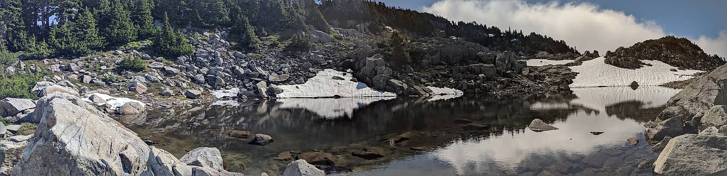 Lower Persis tarn pano 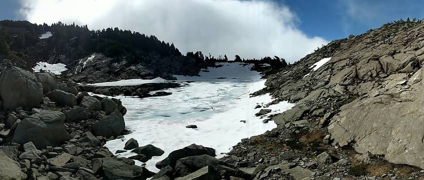 Upper Persis tarn pano 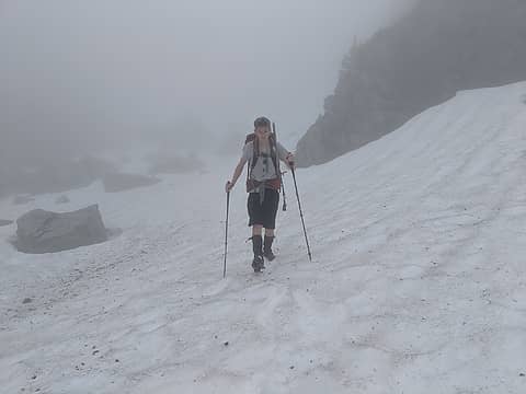 Terrible visibilty 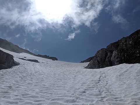 Light at the end of the gully 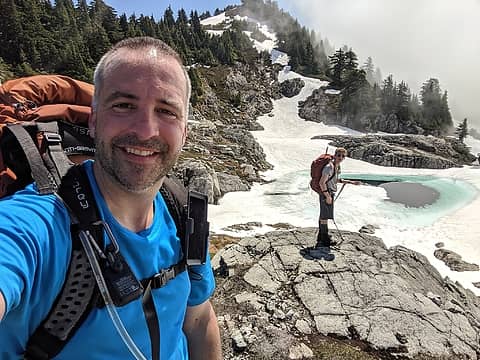 Us at the Persindex tarns 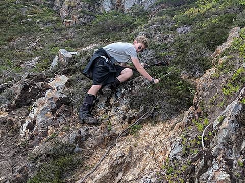 Mason down climbing the tricky stuff 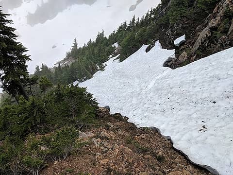 Have to cross the snow while downclimbing 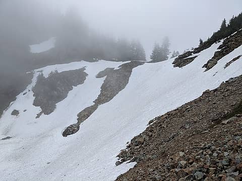 View of the saddle. We chose the rocky channel to ascend. 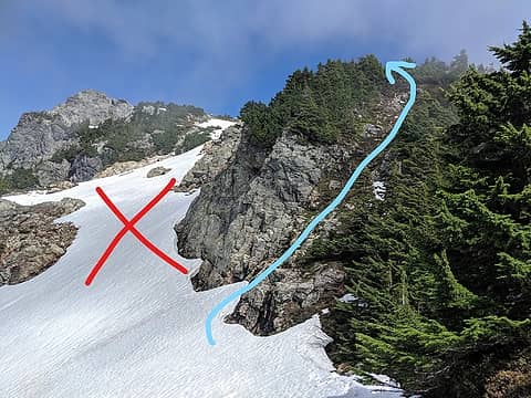 We chose this route. 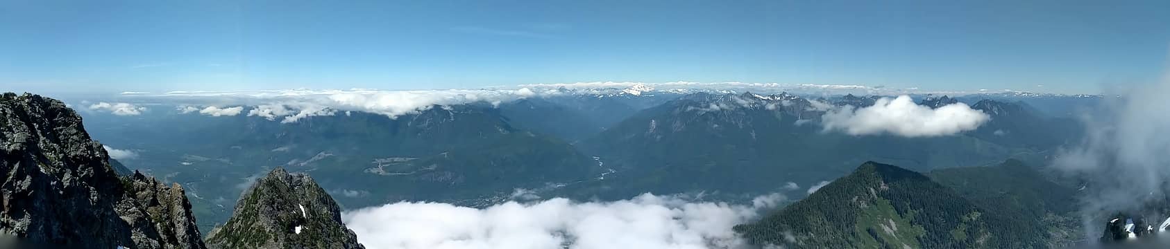 Pano on the summit. 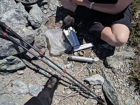 Pipe bomb summit register 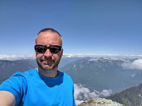 Summit selfie 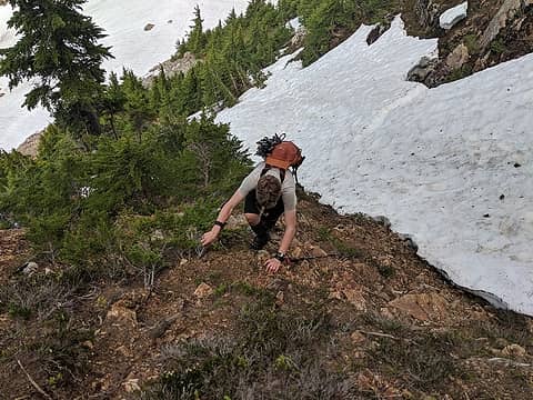 Mason climbing the "tricky bit" 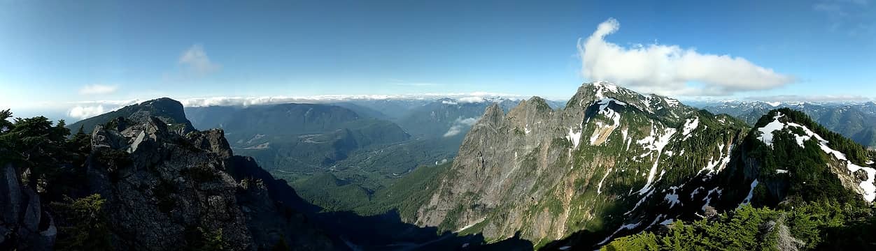 Persindex Pano 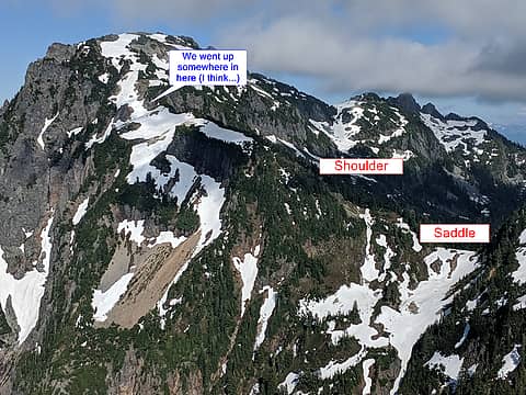 View of Index from Persindex with labels 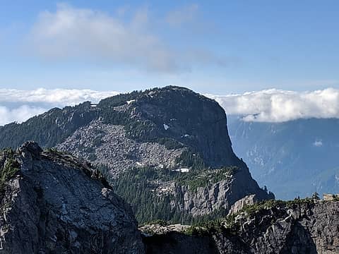 Persis from Persindex 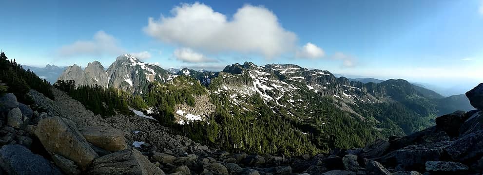 View of the traverse from the boulder field below Persis tarns. 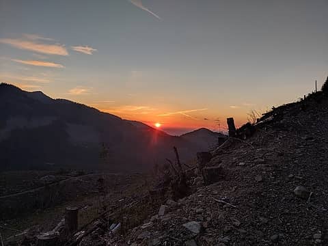 Trailhead sunset.
 healeyio healeyio
healeyio |
| Back to top |
  
|
|
GoodStuff
Member

Joined: 05 Jan 2005
Posts: 6 | TRs | Pics
|
Thanks so much for posting this amazing trip report. And thanks also for all the work you've done clearing the trail. I've gone up a couple times over the last few months to do some clearing but got bogged down carving up a few deadfalls, at least what I could get through with my handsaw. If you're the one who cut the tunnels through the really brushy sections on the lower half, that made a huge difference. The trail is much easier to follow now.
Just curious, did you use had clippers or pruning shears for that? I've been using hand clippers and was thinking I'd bring the pruning shears for a few sections next time I'm up there to maybe be more efficient.
|
| Back to top |
|
|
RichP
Member

Joined: 13 Jul 2006
Posts: 5633 | TRs | Pics
Location: here |
|
RichP
Member
|
 Wed Jun 19, 2019 6:24 am |
|
|
Great beta. Thanks 
|
| Back to top |
|
|
Waterman
Member
Joined: 21 Mar 2015
Posts: 589 | TRs | Pics
Location: Big Snow Quadrangle |
|
Waterman
Member
|
Wed Jun 19, 2019 10:45 am |
|
|
Did you have any part of logging out the many logs that covered the trail 10 years or so ago?
Two roads diverged in a wood, and I,I took the one less traveled by. And that has made all the difference.
Robert Frost
Two roads diverged in a wood, and I,I took the one less traveled by. And that has made all the difference.
Robert Frost
|
| Back to top |
|
|
SultanHiker
Member
Joined: 04 Aug 2014
Posts: 78 | TRs | Pics
Location: Washington |
| GoodStuff wrote: | | Just curious, did you use had clippers or pruning shears for that? I've been using hand clippers and was thinking I'd bring the pruning shears for a few sections next time I'm up there to maybe be more efficient. |
Just used hand clippers (Felco). Something more substantial would be a great help. Unfortunately, I often had deadlines and goals on the way up, so i only helped a tiny bit. My biggest contribution was to a log walk with small trees encroaching climber's right. I went after them vigorously so it was more obvious. Plus it kept them from pushing you off the log...
|
| Back to top |
|
|
SultanHiker
Member
Joined: 04 Aug 2014
Posts: 78 | TRs | Pics
Location: Washington |
| Waterman wrote: | | Did you have any part of logging out the many logs that covered the trail 10 years or so ago? |
Nope. I've never been up FS62 and Persis until last year when I bought the Weyerhaeuser Recreation Pass. The road has been gated so frequently in years past, and I'm only 5 years into my serious hiking career... I sincerely hope that future climbers continue to maintain the trail (at least to a minimum.) The Persis summit and the traverse hold such a special place in my heart. I often see Persis and Index from multiple vantage points from around the Eastside and my commute. But when I get closer to them, it becomes harder to get glimpses (except for North and Middle Index when driving down Hwy2.)
|
| Back to top |
|
|
Mike Collins
Member
Joined: 18 Dec 2001
Posts: 3096 | TRs | Pics
|
The gate is open for both Forest Road 62 and the gate higher up. No need to pay for the Weyerhaeuser permit at this time. Who knows when that will change? This traverse for successful summit bids on Index (main) and Persindex was done over last Sat/Sun. The link will take you to the trailhead for Persis which is the access to the desired traverse. It is a difficult traverse and not a date hike. https://www.wta.org/go-hiking/hikes/mount-persis
Slim
Slim |
| Back to top |
|
|
|
|
You cannot post new topics in this forum
You cannot reply to topics in this forum
You cannot edit your posts in this forum
You cannot delete your posts in this forum
You cannot vote in polls in this forum
|
Disclosure: As an Amazon Associate NWHikers.net earns from qualifying purchases when you use our link(s). |


