| Previous :: Next Topic |
| Author |
Message |
Sadie's Driver
Sadie's Driver


Joined: 24 Apr 2006
Posts: 1763 | TRs | Pics
Location: Welcome Pass |
Well, Barry has wanted to do Cradle Lake forever! He can check that box now! There isn't a lot of information about Cradle Lake, so we were flying a little blind. However, David (Opus) was going to go with us during the Fourth weekend - but he opted for a trip to the Pasayten and decided to do Cradle Lake the weekend before us - - - but he went via a hike over the top of Bootjack and then dropping down to the Snowall-Cradle trail. Since, we have done Bootjack plenty of times, hiking up and over it with full packs, didn't appeal to us one bit!!  Instead, our plan was to take off from the Jack Creek trailhead. Drove out the Icicle Road not terribly early July 3; arrived at the trailhead and were on the trail by 10:30 a.m. Instead, our plan was to take off from the Jack Creek trailhead. Drove out the Icicle Road not terribly early July 3; arrived at the trailhead and were on the trail by 10:30 a.m.
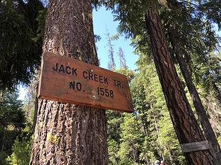 Trailhead 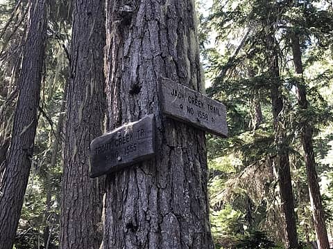 First intersection 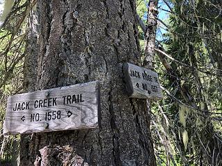 Second intersection 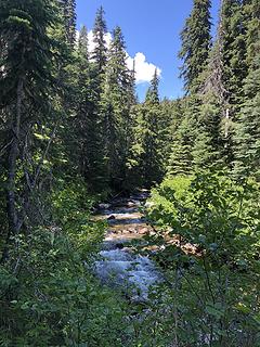 Jack Creek 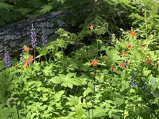 Plenty of wild flowers 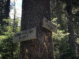 Intersection not where the map says! 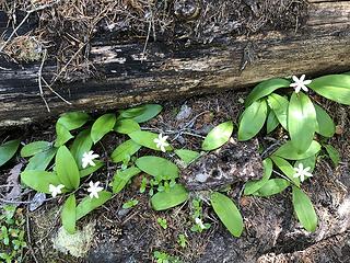 Queens Cup 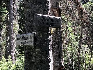 Almost failed to find this turn! 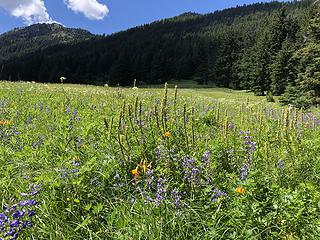 A meadow worth a visit 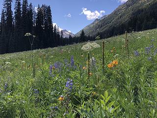 This meadow is amazing 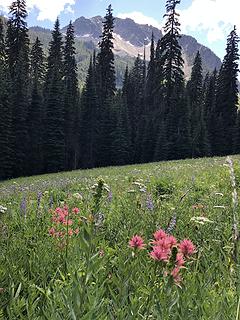 The meadow and Harding 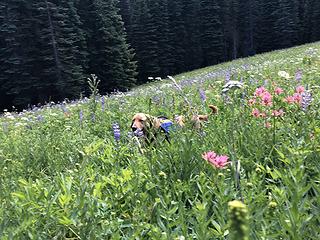 A field dog! 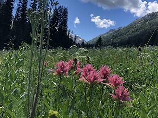 Paintbrush and Tucquala in the distance 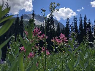 Paintbrush and Harding 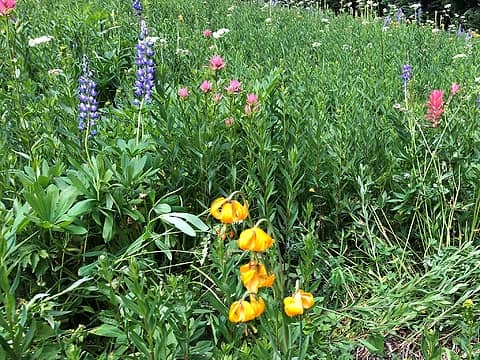 Flowers a' plenty! 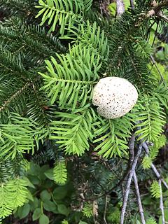 Grouse egg? 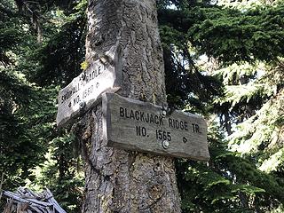 We thought we were sooo close 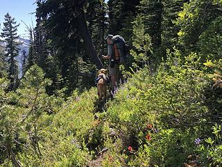 "Almost there" he says!  Why yes they do! 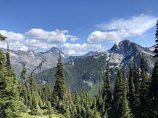 Harding to the right and Stuart in the distance 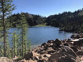 Cradle Lake from the North end 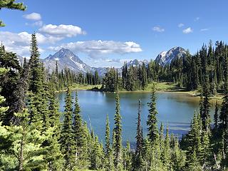 Lovely Cradle Lake 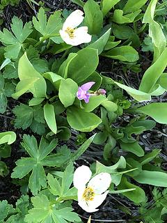 Marsh Marigold & Shooting Star 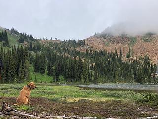 Where did the sun go? 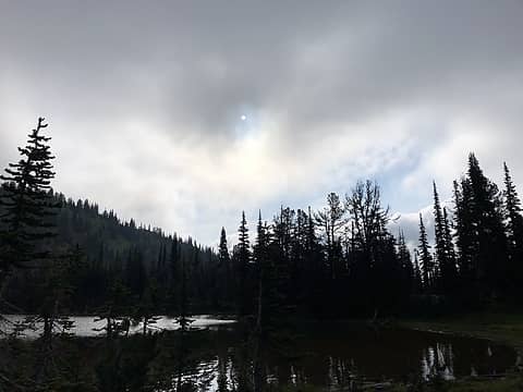 Sun trying to break through 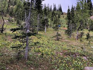 Here we go on our morning jaunt 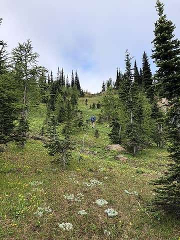 Heading up to the ridge above the lake 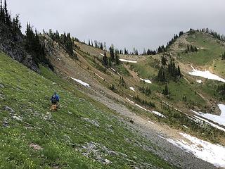 Side-hill to our high point 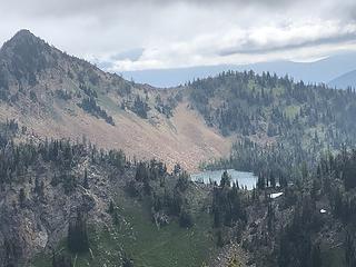 Looking back to Cradle Lake from our high point 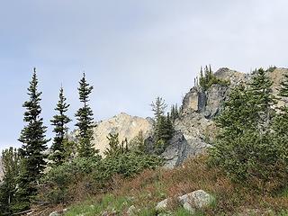 Nursery Peak in the distance 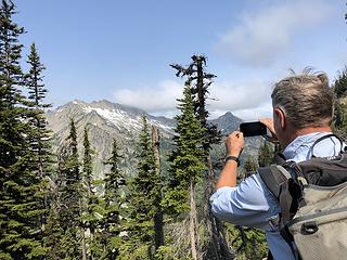 Taking in Cradle Mtn 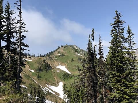 Our little summit for the morning ~6900+' 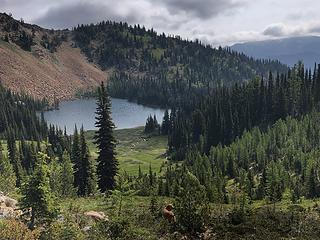 Heading back to camp - above Cradle Lake 
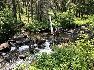 Crossing Meadow Creek 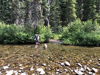 Crossing Jack Creek 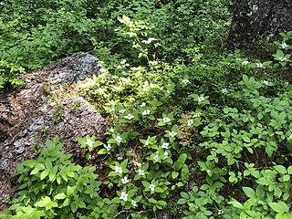 Bunchberry 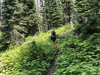 Lush trail along Jack Creek (almost humid!) 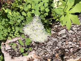 Not sure what this is 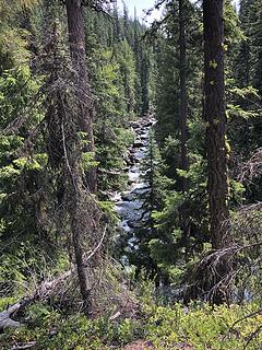 Jack Creek
Four-paw buddy lets me tag along!
Four-paw buddy lets me tag along!
|
| Back to top |
  
|
|
Backpacker Joe
Blind Hiker

Joined: 16 Dec 2001
Posts: 23956 | TRs | Pics
Location: Cle Elum |
Wonderful report. Thank you. Id like to get in there in the fall. There are some nice colors up there. How would you compare what you just did to the BlackJack ridge route to the lake?
"If destruction be our lot we must ourselves be its author and finisher. As a nation of freemen we must live through all time or die by suicide."
Abraham Lincoln
"If destruction be our lot we must ourselves be its author and finisher. As a nation of freemen we must live through all time or die by suicide."
Abraham Lincoln
|
| Back to top |
|
|
RichP
Member

Joined: 13 Jul 2006
Posts: 5634 | TRs | Pics
Location: here |
|
RichP
Member
|
 Sat Jul 06, 2019 7:09 am |
|
|
Really beautiful. Your report has me inspired to visit someday.
|
| Back to top |
|
|
BarbE
Member

Joined: 28 Jul 2006
Posts: 1153 | TRs | Pics
|
|
BarbE
Member
|
Sat Jul 06, 2019 9:14 am |
|
|
Beautiful lush meadow! Looks like an awesome trip!
|
| Back to top |
|
|
Sadie's Driver
Sadie's Driver
Joined: 24 Apr 2006
Posts: 1763 | TRs | Pics
Location: Welcome Pass |
| Backpacker Joe wrote: | | How would you compare what you just did to the BlackJack ridge route to the lake? |
BPJ - we only have been on a short segment of the Black Jack Ridge route - - - once when we did Bootjack - so I don't know a whole lot about that trail. The Eastern Alpine Lakes Green Trails map is correct, "Hard to follow." We did see pass the sign where it comes into the Snowall-Cradle trail. Opus went up to Cradle Lake last weekend - but he stayed even higher than the Black Jack Ridge Route and was about 1/2 way to Hi Chair peak before dropping down to the S-C trail - so he came in even farther than the BJR trail.
I don't know if you would save any mileage coming that way or not - guess it just depends on how hard it is to follow 
Four-paw buddy lets me tag along!
Four-paw buddy lets me tag along!
|
| Back to top |
|
|
Opus
Wannabe

Joined: 04 Mar 2006
Posts: 3700 | TRs | Pics
Location: The big rock candy mountain |
|
Opus
Wannabe
|
Sat Jul 06, 2019 7:08 pm |
|
|
I went in there a few days before, going up and over Bootjack and through that high trail. I had planned to go across the top of Highchair and the next bump on the ridge but a massive hail and thunderstorm caught me and I had to drop down into the forest to ride it out. By then everything was coated in hailstones and super slick so I followed the trail through the trail that zigzags in and out of the basins before reaching Cradle Lake.
Like Barry and Suzanne said, the trail is really where the maps indicate here either. In the upper parts of Ben Creek basin the trail is around a hundred feet higher than USGS shows and crosses the ridge higher and further west before dropping steeply into Pablo Creek basin. More or less easy to follow until it reaches the creek, this time about 100 ft lower than the maps show. Then rising traverse out of the basin to meet the Meadow Creek trail, further east than the map shows.
I'd guess going in via Meadow Creek is easier but going up and over Highchair would save mileage. I went out by Snowall Creek and French Creek. A bit rough dropping down through Snowall and easy to lose in the upper meadows but well logged out. Ford of Snowall was kind of fast but short and the French Creek ford was mid-thigh deep but very slow moving and easy.
|
| Back to top |
|
|
HitTheTrail
Member

Joined: 30 Oct 2007
Posts: 5460 | TRs | Pics
Location: 509 |
| Opus wrote: | | I went in there a few days before, going up and over Bootjack and through that high trail. |
OK, did you happen to see the trail that drops into the basin below Bootjack (where Dunn Creek starts) and then comes up and meets the high route trail to Cradle?
I dropped into that basin to get water before camping on Bootjack a couple of years ago and noticed the trail looked rather good in the basin going towards the high route. Out of curiosity followed it for a ways and it was still looking good before I turned back to my original destination of camping on the summit of Bootjack. I have always though that would be a good way to get to Cradle and skip some of the rocky summit bootpath. There are a few routes on Gaia that show that trail going through. In fact I think that is the original trail before freelancers started going across the top.
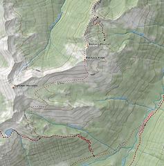 Dunn Creek Basin
|
| Back to top |
|
|
Opus
Wannabe
Joined: 04 Mar 2006
Posts: 3700 | TRs | Pics
Location: The big rock candy mountain |
|
Opus
Wannabe
|
Sat Jul 06, 2019 10:12 pm |
|
|
I saw a spur trail begin to go down into Dunn Creek from a bit further east down the ridge, near where your map shows, but it looked like it faded out fairly quickly in the meadow below. I stayed completely on the ridge crest over Bootjack and on the ridge to the base of Highchair before I dropped down into high meadows, then down a few hundred feet into Ben Creek on a decent trail to escape the hail and lightning. After that there was nearly an inch of hailstones everywhere so any faint trails were really obscured. I sort of made my way back up towards the ridge and over into Pablo Creek drainage and found a very obvious trail off the ridge down into that drainage.
|
| Back to top |
|
|
Type E
Member

Joined: 19 Aug 2006
Posts: 1381 | TRs | Pics
|
|
Type E
Member
|
Sun Jul 07, 2019 9:11 pm |
|
|
Cradle lake still has my favorite view privy
|
| Back to top |
|
|
iron
Member

Joined: 10 Aug 2008
Posts: 6392 | TRs | Pics
Location: southeast kootenays |
|
iron
Member
|
Sun Jul 07, 2019 10:27 pm |
|
|
i thought you didn't post TRs anymore...
|
| Back to top |
|
|
ejain
Member

Joined: 27 Apr 2009
Posts: 1498 | TRs | Pics
Location: Seattle, WA |
|
ejain
Member
|
Sun Jul 07, 2019 10:28 pm |
|
|
|
| Back to top |
|
|
Sky Hiker
Member

Joined: 03 Feb 2007
Posts: 1469 | TRs | Pics
Location: outside |
You can thank Icicle Outfitters for packing in the tools used to work on this trail
|
| Back to top |
|
|
Downhill
Member
Joined: 30 Jul 2018
Posts: 342 | TRs | Pics
Location: Leavenworth |
|
Downhill
Member
|
Mon Jul 08, 2019 12:23 pm |
|
|
Thank you for posting your TR! Your photos are fantastic and have me seriously considering a day trip to the meadow for the flowers.
I visited Cradle Lake in the late '70s and it has remained in my memory as one of my favorite destinations in the region. I've considered returning, but still have a list of places I've yet to visit. Your TR has inspired me to move a return trip up higher on my to-do list. Thanks!
|
| Back to top |
|
|
Sadie's Driver
Sadie's Driver
Joined: 24 Apr 2006
Posts: 1763 | TRs | Pics
Location: Welcome Pass |
Four-paw buddy lets me tag along!
|
| Back to top |
|
|
Sadie's Driver
Sadie's Driver
Joined: 24 Apr 2006
Posts: 1763 | TRs | Pics
Location: Welcome Pass |
| ejain wrote: | | False Bugbane |
Thanks, Ejain!
"You can thank Icicle Outfitters for packing in the tools used to work on this trail." Sky Hiker.
Cool, thanks! I'll stop by and thank them.
Downhill: "Thank you for posting your TR!'
You're welcome - it pretty much wrote itself because of the pictures! It really is a great place. And, yes, it is worth it just to go to the meadows, too!
Four-paw buddy lets me tag along!
Four-paw buddy lets me tag along!
|
| Back to top |
|
|
|
|


