| Previous :: Next Topic |
| Author |
Message |
MidLifeHiker
Member


Joined: 21 Sep 2007
Posts: 193 | TRs | Pics
Location: Mukilteo |
I have been wanting to hike the Foss Lakes to Necklace Valley loop for a couple years now. The forecast showed that there was going to be a change in the wind direction so that the smoke from the Jolly Mountain fire would not be blowing into the Alpine Lakes area for a few days so I took advantage of it. Due to an injury earlier in the season I have had to back off hiking a little, but after climbing Gunn Peak and a 15 mile hike to pick huckleberries I thought I was ready.
I parked down at the Necklace Valley trailhead on Sunday and walk the road to the Foss Lake trailhead. I figured I would rather get the ~2.5 miles out of the way now rather than on Sunday have to hike the extra miles.
I made OK time up Big Heart lake and took a long lunch break and enjoyed laying on a rock in the sun. I passed what must have been 20 people that said they had spent a night or two up at Big Heart Lake. It seemed that nobody had been past Big Heart up to Chetwoot. About half the way from Big Heart Lake to Chetwood, I bumped into two trail runners with their dogs that had planned to make the loop in a single day but couldnt find the route and turned back. From everything I had read, I understood how that could happen. Several years ago, I had attempted this route with a friend, but we found early on that we had different levels of comfort when it came to non-PCT like trails or off trail hiking and determined it was better to turn around at Chetwood. Anyway we met a gal that was trail running the loop and I just didnt think the section between Chetwood and Tank Lakes sounded like an ideal trail for trail running. After doing the loop I am even more amazed that people do this loop in a single day!
The big Tree
Trout Lake
Copper Lake
Little Heart Lake
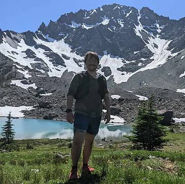
Big Heart Lake
Looking back to Delta and Trout Lake
Lake Angeline
Little tarn on the way
Anyway I made it up to the tarn right above Chetwood sometime mid-late afternoon. The little lake was a little stagnant since there was not water running in or out, but the water was clear and drinkable after filtering it. I was all alone so decided to take a nice dip and cool off after setting up camp and filtering the water.
Finally to the top where Ill camp the first night.
The skies were clear and there was no hint of smoke, so my plan was working. When it got dark the temperature dropped pretty quick, but in the middle of the night it warmed up noticeably. Even in the morning it was t-shirt temperatures. One very surprising thing is that I only saw two mosquitos! Last time I camped here, the bugs were thick.
The next morning my leg was feeling pretty sore, due to the earlier injury and a long day hiking yesterday. I was a little concerned if I was going to be able to make it to Tank Lakes if my leg got any worse. The original plan was to take the high route over Iron Cap, but I decided to take the alternate low route and take a slow pace.
I had found a kml track log and converted it to GPX format so I could upload it on my GPS. Actually I downloaded two, one with the high route and one with the low route. I forgot to note where I copied these so Im sorry if I dont give credit here. I also had maps from both Google Earth and Caltopo.com with the track logs on them just in case. The track of the lower route was actually pretty good. Every time that I started to follow cairns instead of watching the GPS I usually got into trouble.
When I came down to Little Chetwoot the easy path went around the outlet and I saw a large cairn so I figured this must be the way to go. Then I saw another cairn further down toward Angeline and I knew that couldnt be right so went around Little Chetwood and headed up until I got to about 5500 like everything I had read. I didnt take the most efficient route, but made it up to a level area and looked at the GPS again and saw that I was back on route for the lower crossing. I climbed until I reached about 5500 and stayed there as I traversed the rocks, sometimes steep.
Little Chetwoot
Chetwoot
I came around another ridge and thought I was just supposed to cross a little valley and continue on but soon realized this might be a mistake and decided to backtrack and go up the valley to fine a small green lake. I went around and dropped down and crossed the outlet. At this point I was pretty tired and decided to break for lunch.
Most of the route looked like this;
Azure and Azurite Lakes
Turn right up the valley, do not cross it.
Unknown green lake.
After lunch I climbed back up to about 5600 feet for the final crux of the crossing. I probably gain altitude too quickly because there was a class 3-4 move that I could have avoided if I stayed low for another couple hundred yards then climbed up to 5600 feet. After that I had to go through a pretty thicket of scrub firs. I couldnt even put my feet on the ground through about 130 feet of this thicket. After I got through it, I looked back up and probably could have taken an easier path. My arms and legs had cuts all over them.
Heading up to 5600
Otter Lake
Crossing the thicket.
Looking back
I still had about 2/3 of a mile crossing several little valleys before getting to the south ridge that finally winds its way over to Tank Lakes. It was getting pretty hot and I was going through my water a little faster than expected. One of the little valleys still had a snow field and I was able to filter some water. After making it to the south ridge its a pretty easy path up to Tank Lakes although it did seem to take a while just because it was hot and I was tired. Once I got to tank Lakes I found some shade under a tree and relaxed in the shade for about an hour.
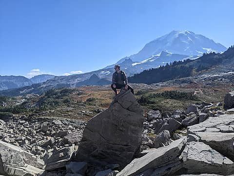
Views from the ridge
Originally I was going to camp at Tank Lakes but the water seemed a bit stagnate, and I really wanted some fresher water and to get an earlier start the next morning. Being tired, the path through the lose rocks down to the valley wasnt fun but I finally made it to a nice camp between Opal and Cloudy Lakes.
I slept pretty good that night and only saw a single gal near the cabin and a group of three guys at the south end of Jade lake on the way out. For the first time, since I started I could smell some smoke in the air and could see the haze of the smoke on the way out, but it wasnt too bad. The trail down to the river is rough and I have heard it called the death march on the way up. Even going down it felt good to cross the river at the bottom and take a break at the camp on the other side. I took my time for the last 5 miles, but was out in less than 2 hours. It usually seems like the trail gets longer on the way out, but since I didnt come in that way, it didnt seem so boring on the way out.
Emerald Lake
Cabin
Jade Lake
After 30 miles of hiking, seeing those cars at the trailhead sure felt good. I was really happy I decided to park here a few days ago and walk the road instead of having to walk another 2.5 miles at this time.
When I opened up the rear hatch, I knew something wasnt right. My car had been broken into and there was a little mess in the back. Luckily the culprit was probably a small furry animal and didnt take anything of value, just make a mess in the Kleenex box. This has happened a couple other times when leaving the car a couple days. I never leave any food or crumbs in the car, so the little critter was probably just scouting for some goodies instead of throwing a party with a bunch of his buddies.
Im glad I finally made the trip. I wish it had been a little cooler on Monday and that my leg hadnt given me problems, but thank god for Advil! Overall I hiked 3 days, went about 30 miles, and climbed almost 7000 feet with all the ups and downs.
Route
Elevation profile
If you are interested, here is the TrackLog.
Mark
|
| Back to top |
  
|
|
puzzlr
Mid Fork Rocks

Joined: 13 Feb 2007
Posts: 7220 | TRs | Pics
Location: Stuck in the middle |
|
puzzlr
Mid Fork Rocks
|
 Mon Sep 18, 2017 11:59 pm |
|
|
Great report. I have yet to visit Tank Lakes, but have been all over a lot of this area. Congrats for getting it done solo.
I know the classic view is lower down with the Chiefs and Chimney Rock looming over the lake, but I like this one a lot too.
|
| Back to top |
|
|
kitya
Fortune Cookie

Joined: 15 Mar 2010
Posts: 842 | TRs | Pics
Location: Duvall, WA |
|
kitya
Fortune Cookie
|
Tue Sep 19, 2017 6:54 am |
|
|
| MidLifeHiker wrote: | | Unknown green lake. |
I think people usually call it "Iron cap lake" because the mountain above it is called Iron Cap. On 2000s map it was still a glacier. I visited it last on September 25th 2011 and it was still almost completely ice, no green water at all.
|
| Back to top |
|
|
reststep
Member

Joined: 17 Dec 2001
Posts: 4757 | TRs | Pics
|
|
reststep
Member
|
Tue Sep 19, 2017 7:00 am |
|
|
Good job, thanks for the report. Glad the smoke stayed out of there for your hike.
I have been to Tank Lakes and to Big Heart and part way to Chetwoot Lake but have not connected them. Something to add to my list.
"The mountains are calling and I must go." - John Muir
"The mountains are calling and I must go." - John Muir
|
| Back to top |
|
|
Sculpin
Member

Joined: 23 Apr 2015
Posts: 1384 | TRs | Pics
|
|
Sculpin
Member
|
Tue Sep 19, 2017 7:58 am |
|
|
Well, there is a lower route yet from the Foss Lakes to Tank Lakes, and from your description, I'm not sure it is not better. We skirted Azurite and then followed meadows and open forest to a bootpath that ascended to the saddle east of Iron Cap. The crux move was getting around Azurite on the south side, which involved a little boulder scrambling. After that, mostly meadow walking and side-hilling.
Between every two pines is a doorway to the new world. - John Muir
Between every two pines is a doorway to the new world. - John Muir
|
| Back to top |
|
|
zimmertr
TJ Zimmerman
Joined: 24 Jun 2018
Posts: 1224 | TRs | Pics
Location: Issaquah |
|
zimmertr
TJ Zimmerman
|
Mon Jul 15, 2019 5:02 pm |
|
|
Hi, thanks for the report. Any chance you could share your GPS track?
|
| Back to top |
|
|
kitya
Fortune Cookie
Joined: 15 Mar 2010
Posts: 842 | TRs | Pics
Location: Duvall, WA |
|
kitya
Fortune Cookie
|
Mon Jul 15, 2019 5:28 pm |
|
|
|
| Back to top |
|
|
zimmertr
TJ Zimmerman
Joined: 24 Jun 2018
Posts: 1224 | TRs | Pics
Location: Issaquah |
|
zimmertr
TJ Zimmerman
|
Mon Jul 15, 2019 5:42 pm |
|
|
Thank you very much for sharing those tracks. I'm not not planning on following them, but rather consulting them when needed. Specifically when trying to determine the precise elevation to best cross over Iron Cap.
If I were to follow a GPS the whole time how could I find time to take in the beautiful views, anyway? 
|
| Back to top |
|
|
MidLifeHiker
Member
Joined: 21 Sep 2007
Posts: 193 | TRs | Pics
Location: Mukilteo |
Zimmertr,
Here's the Track from my 2017 trip.
FossNecklace17.gpx
The only critical point is to make sure you are at about 5600' when you round that point north of Iron Cap, east of Iron Cap Lake. It gets pretty brushy in there, but it doesn't last long. After that just traverse over to the ridge until you pick up the trail.
MidLifeHiker
|
| Back to top |
|
|
|
|
You cannot post new topics in this forum
You cannot reply to topics in this forum
You cannot edit your posts in this forum
You cannot delete your posts in this forum
You cannot vote in polls in this forum
|
Disclosure: As an Amazon Associate NWHikers.net earns from qualifying purchases when you use our link(s). |


