| Previous :: Next Topic |
| Author |
Message |
Jake Robinson
Member


Joined: 02 Aug 2016
Posts: 521 | TRs | Pics
|
Spent the afternoon climbing Chair Peak via the S Shoulder route. This route, while somewhat complicated, is a great way to get to the summit of Chair without any technical climbing. I took ice axe and microspikes but they only served as training weight.
b00 has two great TRs that describe this route. I used his older TR so I'll be referencing that one in this report. I can't thank him enough for the route description, there's no way I would have been able to figure out the route without it. Sorry that my phone photos are so crappy but I hope they are helpful.
b00's report is here: https://www.nwhikers.net/forums/viewtopic.php?t=7970611&highlight=chair
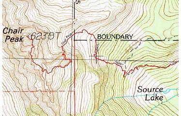 My GPS track 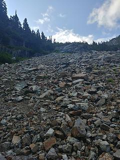 Looking up to the stream gully from the open talus slope 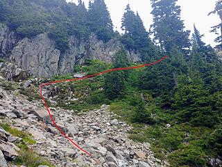 The ramp above the stream gully that leads to the upper basin 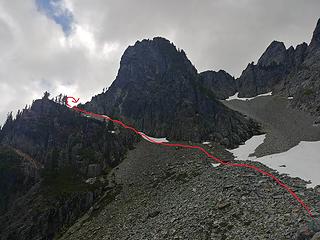 Exit ramp from thumbtack basin. 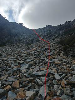 The final slope up to "not bryant" saddle 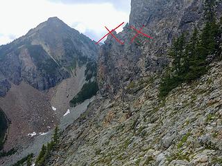 I thought this was the 'lone tree' and correct ramp but it's not the way. Don't try to go here. 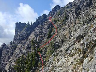 Here is the 'easy gully' seen from the traverse from "not bryant" saddle. The 'isolated tree' is actually a cluster of several trees...I think. 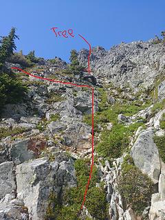 Looking up the easy gully from the base. Dead tree is marked along with where you want to exit. 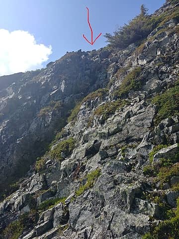 Exit the 'easy gully' here 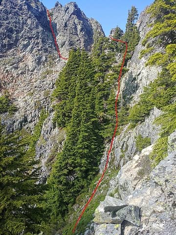 Taken from the exit to the easy gully. Game trail traverse on the right, 'not the summit gully but it's close' on the left. 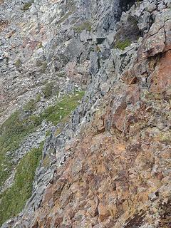 The crux traverse from the top. Looks really hard but it isn't. 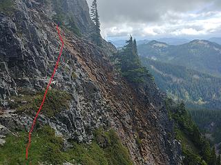 The class 3 downward traverse from the other side. It's easy but don't fall. 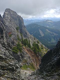 Looking down 'not summit gully but close' gully. Class 3 traverse and game trail visible at the bottom. 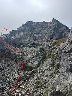 Final class 2 summit gully to the top. 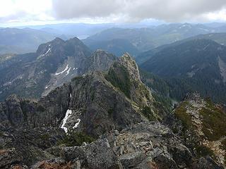 From the summit, looking to Denny Mountain with a lot of the route visible 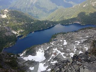 Snow Lake
|
| Back to top |
  
|
|
neek
Member

Joined: 12 Sep 2011
Posts: 2338 | TRs | Pics
Location: Seattle, WA |
|
neek
Member
|
 Fri Jul 19, 2019 9:49 pm |
|
|
Cool! Didn't realize this was possible.
|
| Back to top |
|
|
iron
Member

Joined: 10 Aug 2008
Posts: 6392 | TRs | Pics
Location: southeast kootenays |
|
iron
Member
|
Fri Jul 19, 2019 10:00 pm |
|
|
|
| Back to top |
|
|
Malachai Constant
Member

Joined: 13 Jan 2002
Posts: 16094 | TRs | Pics
Location: Back Again Like A Bad Penny |
Went up this at the end of a Denny to Chair traverse back in the late 70s there was a BM on the South shoulder of Chair that said Bryant Peak. The way is 3-4 choss very exposed. Much prefer the conventional routes if nobody is above you.
"You do not laugh when you look at the mountains, or when you look at the sea." Lafcadio Hearn
"You do not laugh when you look at the mountains, or when you look at the sea." Lafcadio Hearn
|
| Back to top |
|
|
Fletcher
Member

Joined: 29 Jul 2009
Posts: 1870 | TRs | Pics
Location: kirkland |
|
Fletcher
Member
|
Sat Jul 20, 2019 12:45 am |
|
|
This is some serious beta
|
| Back to top |
|
|
Brushbuffalo
Member

Joined: 17 Sep 2015
Posts: 1887 | TRs | Pics
Location: there earlier, here now, somewhere later... Bellingham in between |
| Jake Robinson wrote: | | found two cairns, which assured me I was on route. |
Have I ever been falsely reassured by finding cairns? Indeed. Occasionally folks who have strayed into weird terrain make cairns anyway.
More often than need be it is I who is off route and my bungle is corrected only by cairns that are correctly placed, contradicting my better guess.  So back on route I go, thanks to the initially 'improper' cairn.
This route seems like one of those. Fine job, Jake! So back on route I go, thanks to the initially 'improper' cairn.
This route seems like one of those. Fine job, Jake!
Passing rocks and trees like they were standing still
Passing rocks and trees like they were standing still
|
| Back to top |
|
|
awilsondc
Member

Joined: 03 Apr 2016
Posts: 1324 | TRs | Pics
|
Thanks for the through write up, I'll definitely use this in the future! 
|
| Back to top |
|
|
ozzy
The hard way

Joined: 30 Jul 2015
Posts: 476 | TRs | Pics
Location: University place, wa |
|
ozzy
The hard way
|
Mon Jul 22, 2019 7:38 pm |
|
|
Hell yea nice route Jake!! Thanks for the additional beta, that looks fun! 
I dont know whats gonna happen, but I wanna have my kicks before the whole shithouse goes up in flames-Mr Mojo Risin
I dont know whats gonna happen, but I wanna have my kicks before the whole shithouse goes up in flames-Mr Mojo Risin
|
| Back to top |
|
|
b00
Member

Joined: 29 Sep 2003
Posts: 1144 | TRs | Pics
|
|
b00
Member
|
Mon Jul 22, 2019 11:04 pm |
|
|
| Jake Robinson wrote: | | 7.5 miles, 3400' gain. Took me 4 hours 15 minutes RT. |
stats from my 2017 trip:
7.46mi 3406' gain
4:18 car to summit
0:55 summit stay
4:25 summit to car
9:38 car to car
at least you could have said you did it in 4hours and 20 minutes rt and then you would not have done the whole trip faster than we did half.
you are amazing and i am i'm crying :>)
ps - awesome beta - yours is the t/r i should have written!
|
| Back to top |
|
|
|
|
You cannot post new topics in this forum
You cannot reply to topics in this forum
You cannot edit your posts in this forum
You cannot delete your posts in this forum
You cannot vote in polls in this forum
|
Disclosure: As an Amazon Associate NWHikers.net earns from qualifying purchases when you use our link(s). |


