| Previous :: Next Topic |
| Author |
Message |
rubywrangler
Member


Joined: 04 Aug 2015
Posts: 511 | TRs | Pics
|
Switched out my usual high route guidebook (Routes & Rocks) for the OMCG. The general plan was to link Lillian Ridge with the Low-Lillian-Cameron traverse and then loop back to Obstruction Point by some nondirect route. All new territory for me! And despite some smoke mucking up the views, it was a gorgeous loop.
The Cameron moraine caught my interest in RAW-dad's report from last month, so my initial idea was to climb Mt Cameron via the west ridge, then backtrack to the false summit that connects with "cloudy pass", drop down to the moraine via the pass, then head out via Cedar lake and Deer Ridge. But as soon as I saw the false summit from the ridge, I knew I couldn't get to the pass that way, so Plan A was out.
Plan B was to go up and over Mt Cameron, down the ridge to Lost peak and pass, then loop around to Lost Basin and go out via Cameron basin and Grand Pass/valley. That would've worked according to my research, but I got sketched out about crossing a steep but shallow gully a little ways past the summit of Cameron.
So, impromptu Plan C: I bailed off the ridge a bit past the summit and scree-skiied down to the tarns in Lost basin. Climbed Lost peak the following day (Saturday) via Lost pass, then hiked up and over Cameron pass to Cameron basin, down Cameron Creek, and up to the tarn at 6000' south of Grand Pass. Hiked out early Sunday through Grand Valley. Home with time to spare before watching the Steelers get embarrassed by the Patriots  A little more route detail and photos:
Day 1: Followed bootpath (mostly) from Obstruction Point over Moose mountain to Low pass. From the pass, followed bootpath and cairns into the Lillian River valley. Once in the valley, I picked up the old trail (I assume, it was very well defined) which seems to be a bit higher up than the recommended route in previous reports and the OMCG. I'd like to see a map of this trail but haven't been able to find one. After awhile, the trail dead-ended in a talus field and I had to do a little shwacking to get on the low route, but didn't have any real trouble working my way to the outlet stream and then up to the lake. The one permit for Lillian was reserved so after a long break, I headed up and over the saddle and traversed on old trail to the tarn at ~5750 to camp.
A little more route detail and photos:
Day 1: Followed bootpath (mostly) from Obstruction Point over Moose mountain to Low pass. From the pass, followed bootpath and cairns into the Lillian River valley. Once in the valley, I picked up the old trail (I assume, it was very well defined) which seems to be a bit higher up than the recommended route in previous reports and the OMCG. I'd like to see a map of this trail but haven't been able to find one. After awhile, the trail dead-ended in a talus field and I had to do a little shwacking to get on the low route, but didn't have any real trouble working my way to the outlet stream and then up to the lake. The one permit for Lillian was reserved so after a long break, I headed up and over the saddle and traversed on old trail to the tarn at ~5750 to camp.
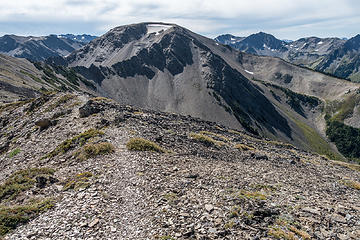 moose 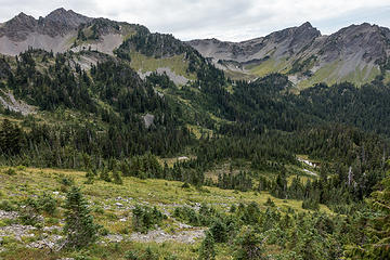 lillian river valley 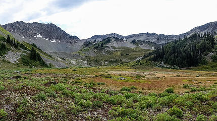 meadow beneath lake lillian 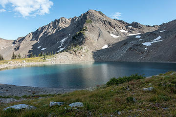 lillian & mccartney 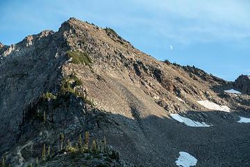 mccartney & moon 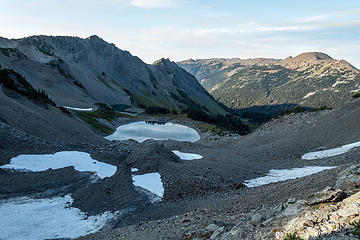 looking back to lillian 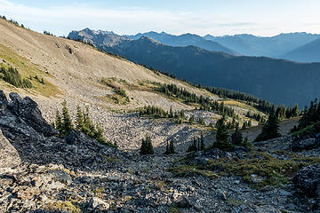 looking south from the saddle 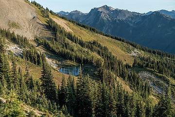 5750 tarn and mt claywood 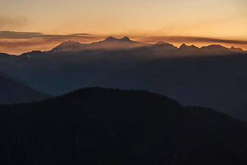 smoky olympus 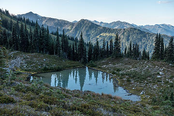 5750 tarn 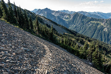 yay trail!  cameron from the notch north of pt 6450 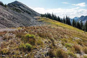 brief break from sidehilling 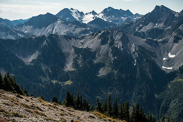 anderson 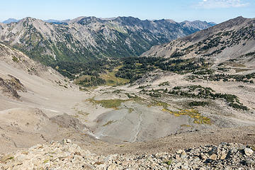 cameron basin 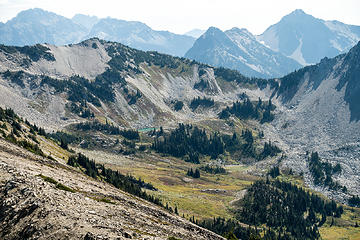 lost basin and smoky haze beyond 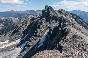 true summit center, behind false summit 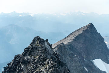 camera unable to focus due to smoky haze 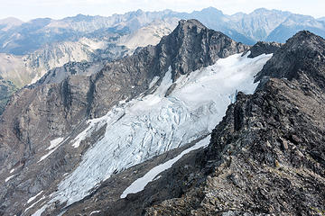 cameron glacier 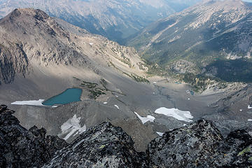 cameron moraine 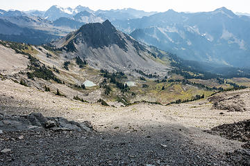 scree slopes to lost basin 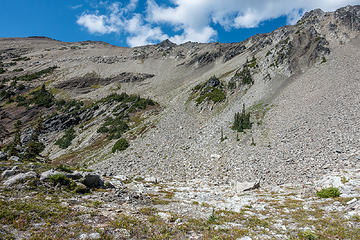 looking back up to cameron (false summit center, true summit just right of false summit) 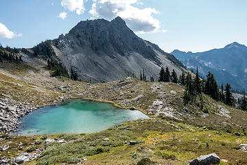 lost & tarn 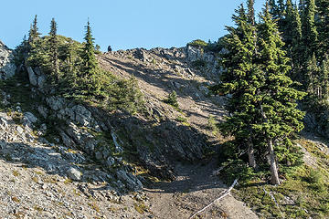 bear buddy on the ridge 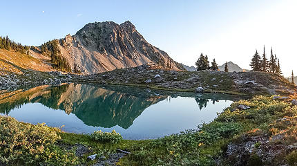 lost peak and tarn and camp 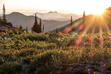 golden hour 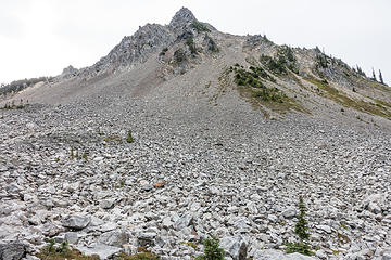 lost peak talus bonanza 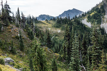 lost pass 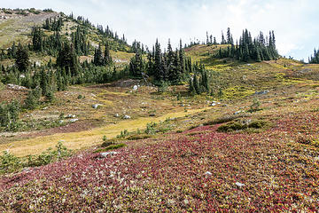 ridge to lost peak from the pass 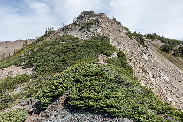 lost summit 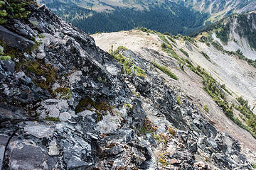 ridge from lost summit block 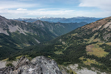 lost river valley 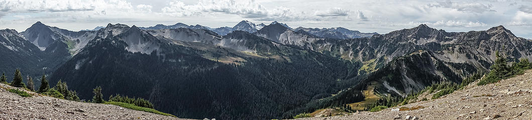 pano view across the dosewallips 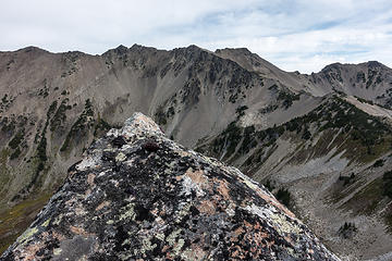 lost summit, cameron beyond 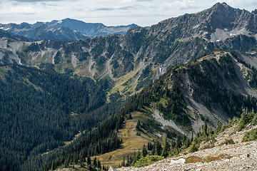 looking toward hayden pass 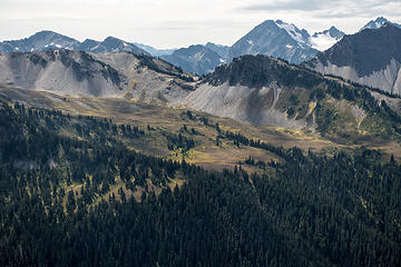 thousand acre meadow & anderson 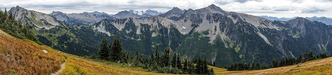 pano looking SW from below cam pass 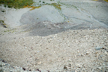 wiggly trail to cam basin 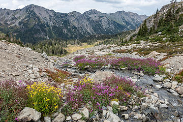 cam basin 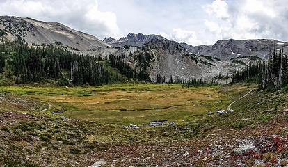 cam basin 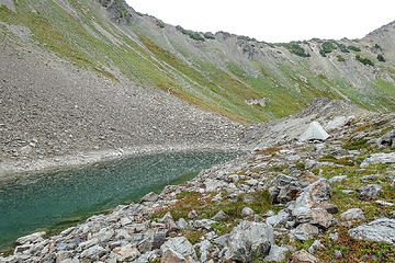 grand pass tarn camp 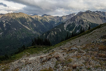 view across the cameron creek valley from camp 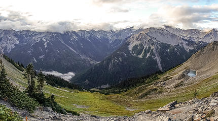 grand pass view 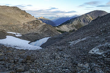 grand pass tarn 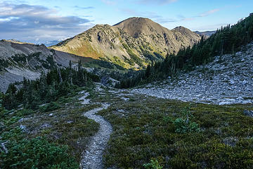 descending to grand valley, moose 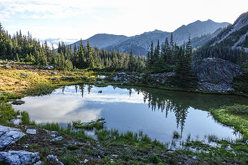 grand valley
|
| Back to top |
  
|
|
RAW-dad
Member

Joined: 07 Jul 2017
Posts: 119 | TRs | Pics
Location: Oregon |
|
RAW-dad
Member
|
 Wed Sep 11, 2019 6:47 am |
|
|
Nice TR.  Too bad plan A didn't work out - it's a fun traverse to Cedar Lake. Here's a pic looking up from the top of the moraine. Wouldn't want to come down that!
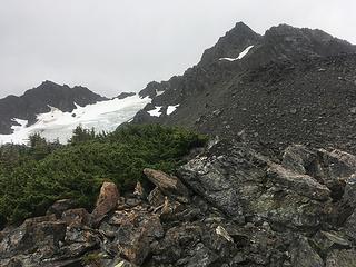 Looking up at Cameron
|
| Back to top |
|
|
IanB
Vegetable Belayer
Joined: 21 Jul 2010
Posts: 1062 | TRs | Pics
Location: gone whuljin' |
|
IanB
Vegetable Belayer
|
Wed Sep 11, 2019 7:59 am |
|
|
Your photos are absolutely amazing!
Darn nice trip for a "Plan C"!!
"Forget gaining a little knowledge about a lot and strive to learn a lot about a little." - Harvey Manning
"Forget gaining a little knowledge about a lot and strive to learn a lot about a little." - Harvey Manning
|
| Back to top |
|
|
cascadetraverser
Member

Joined: 16 Sep 2007
Posts: 1407 | TRs | Pics
|
Nice linkage of cool place to cool place!
|
| Back to top |
|
|
reststep
Member

Joined: 17 Dec 2001
Posts: 4757 | TRs | Pics
|
|
reststep
Member
|
Wed Sep 11, 2019 3:39 pm |
|
|
Thank you for the report and pictures to some of my favorite places in the Olympic Mountains.
How bad was the thunder storm where you were? Did you consider bailing out to a lower elevation campsite?
"The mountains are calling and I must go." - John Muir
"The mountains are calling and I must go." - John Muir
|
| Back to top |
|
|
rubywrangler
Member
Joined: 04 Aug 2015
Posts: 511 | TRs | Pics
|
| RAW-dad wrote: | | Too bad plan A didn't work out - it's a fun traverse to Cedar Lake |
I hope to do it sometime! But will probably go in the same direction you did.
| reststep wrote: | | How bad was the thunder storm where you were? Did you consider bailing out to a lower elevation campsite? |
The lighting was nearly continuous but there was no thunder and no rain and the lighting didn't seem to be striking the ground. I did consider moving but it was a long way down to flat ground in either direction, and since the storm didn't seem to actually be that close, I decided to stay put.
|
| Back to top |
|
|
RodF
Member

Joined: 01 Sep 2007
Posts: 2593 | TRs | Pics
Location: Sequim WA |
|
RodF
Member
|
Thu Sep 12, 2019 12:53 pm |
|
|
Yours was a great plan to bag the best views! Thanks for sharing your wonderful photos!
| rubywrangler wrote: | | But as soon as I saw the false summit from the ridge, I knew I couldn't get to the pass that way, so Plan A was out. |
me, too!
"of all the paths you take in life, make sure a few of them are dirt" - John Muir
"the wild is not the opposite of cultivated. It is the opposite of the captivated - Vandana Shiva
"of all the paths you take in life, make sure a few of them are dirt" - John Muir
"the wild is not the opposite of cultivated. It is the opposite of the captivated - Vandana Shiva
|
| Back to top |
|
|
boomheist
Member
Joined: 25 Jul 2009
Posts: 55 | TRs | Pics
Location: tacoma |
"Cloudy Pass" has now been referenced a couple of times by those wandering the Cameron traverse area, which is great. That's what we decided to call that place when Rod and I did that traverse a few years ago. Seems the name has stuck. I am thinking it's time to go back...
|
| Back to top |
|
|
raising3hikers
Member
Joined: 21 Sep 2007
Posts: 2344 | TRs | Pics
Location: Edmonds, Wa |
That really looks like a great trip! Thanks for sharing
|
| Back to top |
|
|
Brushbuffalo
Member

Joined: 17 Sep 2015
Posts: 1887 | TRs | Pics
Location: there earlier, here now, somewhere later... Bellingham in between |
Fabulous trip, Megan!
| rubywrangler wrote: | | The lighting was nearly continuous but there was no thunder and no rain and the lighting didn't seem to be striking the ground. I did consider moving but it was a long way down to flat ground in either direction, and since the storm didn't seem to actually be that close, |
Typically what is imprecisely called ' heat lightning' is where the source is about 15 or more miles from the observer. The flash is seen ( if within a cloud, called ' sheet lightning') but the sound (thunder) is not received.*
But that doesn't mean there is no hazard. It also doesn't necessarily warrant immediate remedial action, just continual observation.
*Many of you know this. The light from lightning gets to an observer essentially instantaneously, while sound takes about 5 seconds to travel one mile. So five seconds from 'flash to crash' means the source is only a mile away.
If you count 15 seconds from flash to crash, then soon after, ten seconds, and minutes later just 5 seconds, you'd better hope you are not on an exposed ridge, summit, open area, or even under a large sap- filled tree that could literally explode in a direct hit by lightning.
Here are some tips about staying safe with lightning around.
Passing rocks and trees like they were standing still
Passing rocks and trees like they were standing still
|
| Back to top |
|
|
|
|
You cannot post new topics in this forum
You cannot reply to topics in this forum
You cannot edit your posts in this forum
You cannot delete your posts in this forum
You cannot vote in polls in this forum
|
Disclosure: As an Amazon Associate NWHikers.net earns from qualifying purchases when you use our link(s). |


