| Previous :: Next Topic |
| Author |
Message |
kitya
Fortune Cookie


Joined: 15 Mar 2010
Posts: 842 | TRs | Pics
Location: Duvall, WA |
|
kitya
Fortune Cookie
|
 Sun Oct 06, 2019 11:28 am |
|
|
I couldn't find much information about Massie lake online, including I've not found any autumn photos of it, so i was not sure if it has larches or not, so I didn't know what to expect and thus Massie lake exceeded my expectations by a lot.
Me and Cookie arrived at 9:30am to shockingly completely empty Trinity parking lot. Road is at its usual bad, but hey, at least it is not the road up Phelps creek. Any car can make it. I don't remember ever seeing Trinity empty before and I thought this area is prime for autumn adventures.
It was raining on and off a little bit as we walked through beautiful wet forest along Chiwawa river trail.
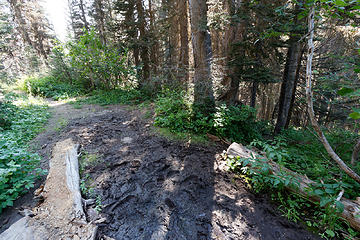
Forest service sign at the trailhead warned that Massie lake trail is not maintained for horses.This must be a joke. Who is it maintained for and by? Mountain goats? Maybe I'm blind, but I have not found any evidence of the trail. So instead i gave up searching and just forded Chiwawa river and scrambled steep wet and sometimes snowy brush up to Massie lake pretty much straight up. It is short, but steep (lots of veggie belays) and I was completely wet from fording the river and wet forest. It was cold.
Massie lake is surprisingly beautiful and does have an evidence of faint trail near to the shoreline. You couldn't see it from down below, but the basin is filled with larches. It is even prettier (and more snowy) heading up to the gap to join Massie Lake High route.
After miserable and wet climb up from Chiwawa river trail, high route is such a treat. The views to Buck mountain are amazing. Looks like Buck already accumulated significant snow. There are tons of blueberries still and pleasant open grassy slopes with ton of animal tracks (lots of deer too) that are just a pleasure to walk on.
Unfortunately what comes up must eventually come down. After a couple of miles high route hits cliffy area where a steep downclimb is necessary to cross. It started snowing again and was painfully slow and slippery. Eventually I had to choose to climb back up to the high route on the other side of the cliffs or just drop additional 0.3 miles to buck creek trail. I choose buck creek trail and we walked back to the car from there, making for an easy 20+ miles day loop.
 zimmertr zimmertr
zimmertr |
| Back to top |
  
|
|
Backpacker Joe
Blind Hiker

Joined: 16 Dec 2001
Posts: 23956 | TRs | Pics
Location: Cle Elum |
Beautiful pics, but where's the lake? There is intact a trail to the lake. You simply need to know where to turn left off the main trail. 
"If destruction be our lot we must ourselves be its author and finisher. As a nation of freemen we must live through all time or die by suicide."
Abraham Lincoln
"If destruction be our lot we must ourselves be its author and finisher. As a nation of freemen we must live through all time or die by suicide."
Abraham Lincoln
|
| Back to top |
|
|
kitya
Fortune Cookie
Joined: 15 Mar 2010
Posts: 842 | TRs | Pics
Location: Duvall, WA |
|
kitya
Fortune Cookie
|
Sun Oct 06, 2019 3:58 pm |
|
|
| Backpacker Joe wrote: | | Beautiful pics, but where's the lake? There is intact a trail to the lake. You simply need to know where to turn left off the main trail. |
The very first photo has a part of the lake!
Well, I never found that secret turn left! Is there any mark on it?
|
| Back to top |
|
|
Backpacker Joe
Blind Hiker
Joined: 16 Dec 2001
Posts: 23956 | TRs | Pics
Location: Cle Elum |
PM sent
"If destruction be our lot we must ourselves be its author and finisher. As a nation of freemen we must live through all time or die by suicide."
Abraham Lincoln
"If destruction be our lot we must ourselves be its author and finisher. As a nation of freemen we must live through all time or die by suicide."
Abraham Lincoln
|
| Back to top |
|
|
Randy
Cube Rat

Joined: 18 Dec 2001
Posts: 2910 | TRs | Pics
Location: Near the Siamangs |
|
Randy
Cube Rat
|
Sun Oct 06, 2019 5:01 pm |
|
|
Unless it has somehow been obscured in recent years, you must just not have gone far enough. It has always been a very obvious left turn. I'm sure BPJ will provide good directions.
|
| Back to top |
|
|
Damian
Member

Joined: 18 Dec 2001
Posts: 3260 | TRs | Pics
|
|
Damian
Member
|
Sun Oct 06, 2019 6:02 pm |
|
|
|
| Back to top |
|
|
kitya
Fortune Cookie
Joined: 15 Mar 2010
Posts: 842 | TRs | Pics
Location: Duvall, WA |
|
kitya
Fortune Cookie
|
Sun Oct 06, 2019 6:21 pm |
|
|
| Randy wrote: | | Unless it has somehow been obscured in recent years, you must just not have gone far enough. It has always been a very obvious left turn. I'm sure BPJ will provide good directions. |
Maybe! Maybe I'm just stupid. Perhaps I didn't expect to see it, so I wasn't really looking. The trip reports I looked at before, like this latest one on wta indicate other people seem to not be able to find it either - https://www.wta.org/go-hiking/trip-reports/trip_report.2019-07-13.0789180514
Looks like this trip report from summitpost indicates they followed the trail, but it is not clear from the report if following the trail is easier than just going up through the forest or not - https://www.summitpost.org/massie-lake/373477
Anyway, I turned left where it should have been based on map. It is unlikely I'll ever use this information, because I tend not to repeat the trips, but anyway here is my track: https://connect.garmin.com/modern/activity/4128948935 and maybe you can tell me where I went wrong? Personally, maybe I think I should have done it the other way, i.e. come to Massie High route first (really enjoyable) and than drop down to Massie lake. Going almost all the way in wet boots from Chiwawa ford was kind of stupid, I guess. I probably also should have taken my rain pants 
|
| Back to top |
|
|
Brushbuffalo
Member

Joined: 17 Sep 2015
Posts: 1887 | TRs | Pics
Location: there earlier, here now, somewhere later... Bellingham in between |
Beautiful. That's a good one this time of year esp with shorter days. Less ambitious folks are perhaps timid with the snowfall.
She's saying " come on, Mom!"
Passing rocks and trees like they were standing still
Passing rocks and trees like they were standing still
|
| Back to top |
|
|
rubywrangler
Member

Joined: 04 Aug 2015
Posts: 511 | TRs | Pics
|
I couldn't find the trail immediately after crossing the river either, so I just headed directly west and after about 500' (up) I ran into it. Once I was on the trail, it was easy to follow and not as steep as I had expected. It was definitely easier than bushwhacking!!
|
| Back to top |
|
|
kitya
Fortune Cookie
Joined: 15 Mar 2010
Posts: 842 | TRs | Pics
Location: Duvall, WA |
|
kitya
Fortune Cookie
|
Mon Oct 07, 2019 6:04 pm |
|
|
| rubywrangler wrote: | | I couldn't find the trail immediately after crossing the river either, so I just headed directly west and after about 500' (up) I ran into it. Once I was on the trail, it was easy to follow and not as steep as I had expected. It was definitely easier than bushwhacking!! |
Well, everyone makes me look stupid for bushwacking all the way up. Would be nice if someone put a cairn or something or gps coordinates of the trail. For future generations
|
| Back to top |
|
|
rubywrangler
Member
Joined: 04 Aug 2015
Posts: 511 | TRs | Pics
|
I'd call it determined, not stupid (I'm the opposite and will spend a lot of time looking for a trail or bootpath if I know one exists, because I'm lazy!)
|
| Back to top |
|
|
sooperfly
Member

Joined: 04 May 2003
Posts: 1234 | TRs | Pics
Location: North Central Wa. |
Here's the trail cut-off and the creek crossing. Sorry to hear you didn't hit the trail going up. Would have made an easier, if not as adventurous ascent.
 Massie-Cut-Off 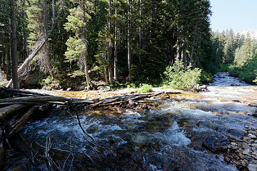 Creek-Crossing
|
| Back to top |
|
|
Leafguy
Member

Joined: 16 Sep 2003
Posts: 525 | TRs | Pics
Location: Wenatchee |
|
Leafguy
Member
|
Mon Oct 07, 2019 8:42 pm |
|
|
Last time I went up to Massie (5-6 years ago) the lower part of the trail was pretty much gone. We stayed to the right (west) to get around the mess and picked the trail up again as others have said. I don't recall having to bushwhack 500' of elevation but it was a b**** regardless. Steve has told me it was an old sheep run as evidenced by the old sheepherder camp above the lake. There were still parts of an old stove there (at the sheepherder camp)at one time.
A beautiful place for sure. Don't know if I can even get up there again. I sure hope so.
|
| Back to top |
|
|
|
|


