| Previous :: Next Topic |
| Author |
Message |
GaliWalker
Have camera will use


Joined: 10 Dec 2007
Posts: 4931 | TRs | Pics
Location: Pittsburgh |
|
GaliWalker
Have camera will use
|
 Fri Oct 04, 2019 10:34 am |
|
|
Adirondacks (Sep 28 - Oct 2, 2019)
The Adirondacks, in Upstate New York, are my favorite hiking destination on the east coast. Sparkling lakes nestle amidst the folds of a blanket of peaks. The views from the tops are sublime, although getting to experience them requires a bit of work, since the terrain is steep and rugged. The end of September through mid-October usually coincides with peak fall foliage; a riot of colors marches up and down the mountain slopes, enchanting one and all.
Sep 28: Arrival, Cascade Lakes; Split Rock Falls; Connery Pond
After leaving Pittsburgh around 3:00am I made the painstakingly long drive to upstate New York, to arrive in the pretty town of Lake Placid a little after noon. I checked into my motel, and home for the next four nights, and took stock. I didn't want to do anything too strenuous on this arrival day, wanting to conserve my strength for the days to come.
Even though the cloud deck was low and there was no prospect of views I decided to check out Connery Pond first, which has a great view of Whiteface Mountain. As expected, Whiteface Mountain was a no-show, but it was still cool to soak in the serenity.
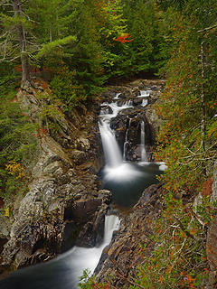
For me an overcast day usually means finding a waterfall to photograph. I decided to head over to Split Rock Falls. On the drive I stopped by Upper and Lower Cascade Lakes, which lay right beside the road.
After my photography stop at Cascade Lakes I continued onwards to the trailhead for Split Rock Falls. The waterfall was quite beautiful: a double drop into a large splash pool, and then a third drop down into an even larger pool.
 7 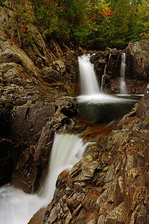 8 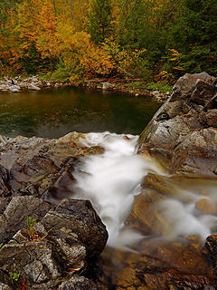 9 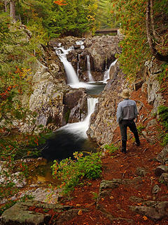 10- GaliWalker at Split Rock Falls (selfie) 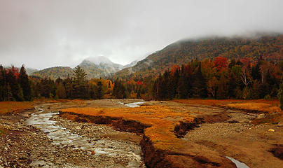 11- Site of Marcy Dam 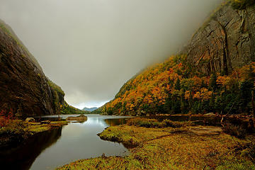 12 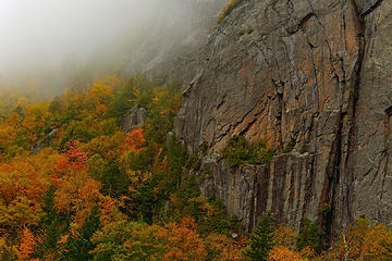 13 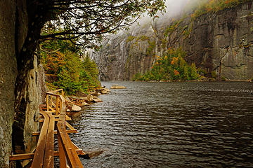 14- Hitch-up Matildas 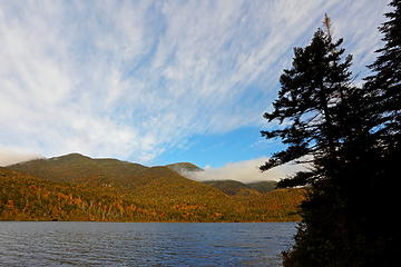 15 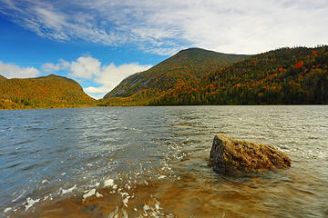 16 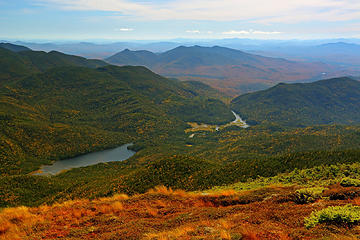 17- Lake Colden and the Flowed Lands 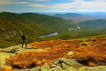 18- GaliWalker on Algonquin (selfie) 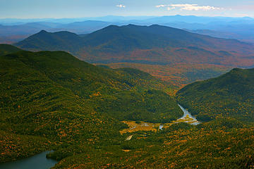 19 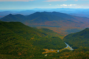 20- The Flowed Lands 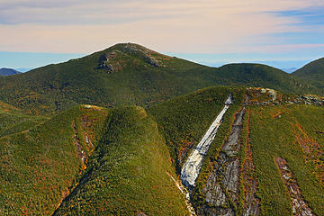 21- Mount Colden with slides, and Mount Marcy 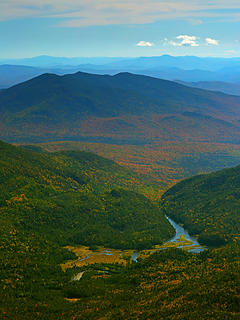 22 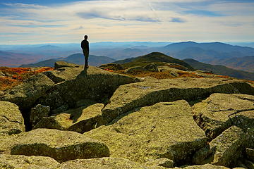 23- GaliWalker looking at Iroquois Peak (selfie) 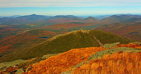 24 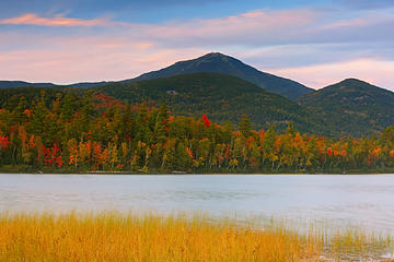 25 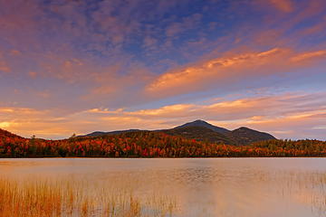 26
|
| Back to top |
  
|
|
GaliWalker
Have camera will use
Joined: 10 Dec 2007
Posts: 4931 | TRs | Pics
Location: Pittsburgh |
|
GaliWalker
Have camera will use
|
Fri Oct 04, 2019 10:34 am |
|
|
Sep 30: Mount Jo; Giant Mountain
I rolled out of bed, bleary eyed from a nearly sleepless night, and a mass of aches from the previous day's tough hiking. It was forecast to be the best weather day on my trip, so I decided to focus on photography rather than a more strenuous hike. I had a couple of must visit locations that I thought weren't going to require too much exertion, so I decided I would bookend them around a day of relative sloth.
Mount Jo
My first shooting location was Mount Jo, a perch which sports a fantastic view of the high peaks, particularly Algonquin Mountain, which I'd climbed the day before. The trailhead was located at the Adirondack Loj, and used the same parking lot as for my Algonquin Mountain hike. Thankfully, this was much less crowded compared to the previous day.
I began hiking by 6:30am. My plan was to head up to the summit by the Short Trail and take the Long Trail back down, making for a 2mi loop. The 0.8mi Short Trail was surprisingly steep, and I was rudely reminded of how rugged the Adirondacks are. There's nothing that doesn't require exertion.
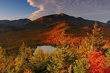
The summit block sported a small window on Heart Lake. Fog was gently lifting off the lake surface in the soft morning sunshine. Shadows rippled amongst the slopes marching up to Algonquin Mountain, which took center stage, and its neighbors. It was a sea of red and gold.
 27 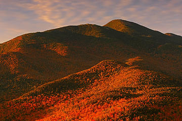 28- Algonquin Mountain 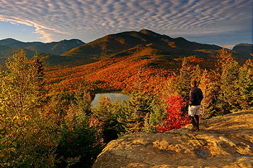 29- GaliWalker on Mount Jo (selfie) 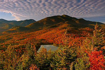 30 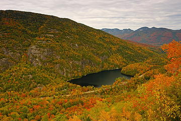 31 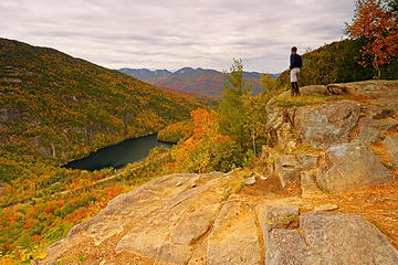 32 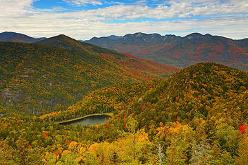 36- Giant's Washbowl 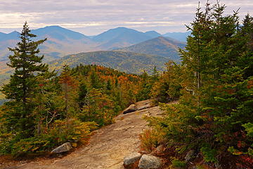 37- Ridge Trail slabs (taken on return) 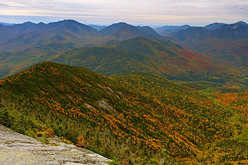 38 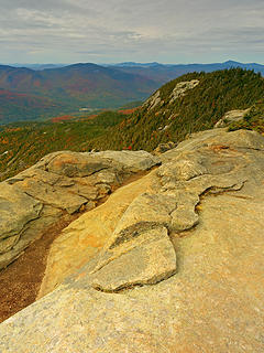 39 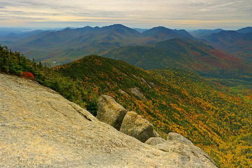 40 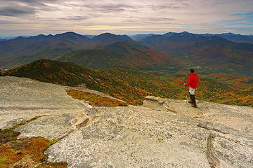 41- GaliWalker on Giant (selfie) 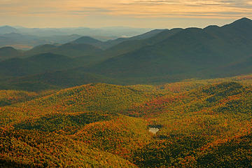 42- Round Pond 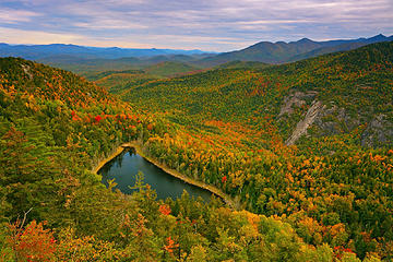 43
|
| Back to top |
|
|
GaliWalker
Have camera will use
Joined: 10 Dec 2007
Posts: 4931 | TRs | Pics
Location: Pittsburgh |
|
GaliWalker
Have camera will use
|
Fri Oct 04, 2019 10:34 am |
|
|
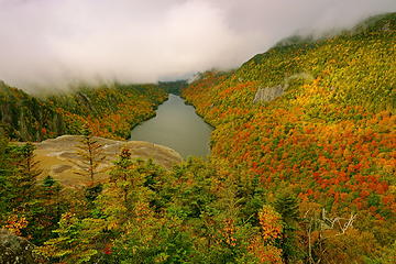
Oct 1: Indian Head and Fish Hawk Cliffs
After two days of relatively nice weather rain had moved in. The next two days were supposed to feature wall-to-wall precipitation. With this in mind, I decided to change my plan of climbing Mount Marcy, New York's highest point, and focus on more intimate views. Two years ago I'd done a loop hike to Indian Head, which sported expansive views of lakes and peaks. While a repeat trip there wouldn't cover any new ground, I would get to soak in those views in nearly prime fall foliage conditions.
The hike began from the parking lot for the Ausable Club. It was raining steadily so, as is my custom in these conditions, I traded my trekking pole for my umbrella. The umbrella is extremely useful in keeping the camera dry while taking pictures.
There are at least three routes to get to Indian Head, two of which I'd used in the past. This time I chose the third, the easiest one, because the conditions were so miserable and my legs were still fried from the previous days' exertions. This was a 4.5mi road walk to the mouth of Lower Ausable Lake, with a final 0.5mi section of trail. The latter was a typically steep Adirondacks trail, which ingeniously took me around or over rock outcrops, aided by three ladders, and one instance of wooden steps bolted into the face of a large rock slab.
As I approached the Indian Head vista - an expansive throne of rock overlooking Lower Ausable Lake - amazingly the rain stopped. I even began to get fleeting glimpses of blue sky as waves of clouds streamed up the valley. Indian Head was extremely windy. Initially, the only view was the one down to Ausable Lake. The longer I waited, the better it got though. Dramatic sunshine began to play on the mountainsides. Upper Ausable Lake would appear and disappear in the distance as the cloud deck heaved or settled. Eventually, the mist rose high enough that Mount Colvin, to one side, and the Great Range, to the other, were revealed in all their glory.
 44 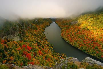 45 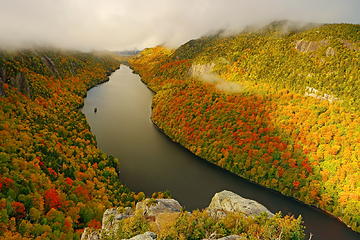 46 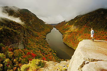 47- GaliWalker and clouds on Mount Colvin (selfie) 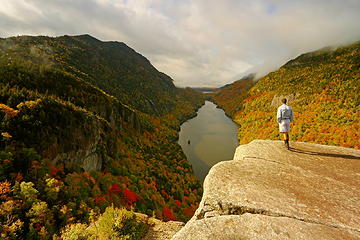 48- GaliWalker on Indian Head (selfie) 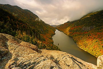 49 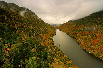 50 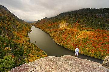 51- GaliWalker on Fish Hawk Cliffs (selfie) 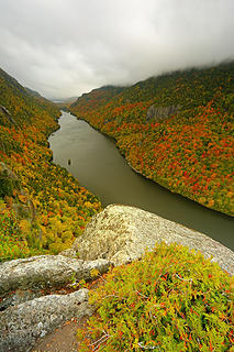 52 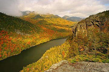 53- Indian Head and the Great Range 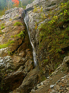 54 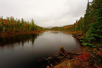 59 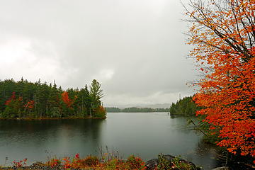 60
|
| Back to top |
|
|
Backpacker Joe
Blind Hiker

Joined: 16 Dec 2001
Posts: 23956 | TRs | Pics
Location: Cle Elum |
Great pics as usual GaliMeister. 
"If destruction be our lot we must ourselves be its author and finisher. As a nation of freemen we must live through all time or die by suicide."
Abraham Lincoln
"If destruction be our lot we must ourselves be its author and finisher. As a nation of freemen we must live through all time or die by suicide."
Abraham Lincoln
|
| Back to top |
|
|
Malachai Constant
Member

Joined: 13 Jan 2002
Posts: 16100 | TRs | Pics
Location: Back Again Like A Bad Penny |
This was our first hike in the Adirondacks when I was working in Ottawa. Arrogantly we thought it would not be much harder than Tiger Mountain. We hiked to Marcy Dam which was a pond then and beautiful, Next we hit Coldin camping near a lean to on the ridge of Wright. We then headed up a slide on Algonquin which was shown as a trail a bare granite slab for 2000. As you did we descended the main trail which was very rocky. After that we had a lot more respect for the Daks. We returned after Sandy and Marcy dam was a wasteland and the punching trail reduced to kindling. I posted a report here at the time. We hit most of the high peaks in the area for the next few years. The Daks are my favorite range on the East Coast much more rugged than the Presidential range. Beautiful pictures Gali.
"You do not laugh when you look at the mountains, or when you look at the sea." Lafcadio Hearn
"You do not laugh when you look at the mountains, or when you look at the sea." Lafcadio Hearn
|
| Back to top |
|
|
wildernessed
viewbagger

Joined: 31 Oct 2004
Posts: 9275 | TRs | Pics
Location: Wenatchee |
Spectacular as usual the High Peaks Wilderness is pretty rugged travel.
Living in the Anthropocene
Living in the Anthropocene
|
| Back to top |
|
|
meck
Member

Joined: 31 Dec 2010
Posts: 920 | TRs | Pics
|
|
meck
Member
|
Sat Oct 05, 2019 8:24 am |
|
|
Beautiful pictures as always GW! The terrain has quite a different feel from around here. You ever thought about turning any of your pictures into jigsaw puzzles?
*Just say NO to Rent-Seeking, don't give up the concept of "ownership"*
*Just say NO to Rent-Seeking, don't give up the concept of "ownership"*
|
| Back to top |
|
|
GaliWalker
Have camera will use
Joined: 10 Dec 2007
Posts: 4931 | TRs | Pics
Location: Pittsburgh |
|
GaliWalker
Have camera will use
|
Sat Oct 05, 2019 12:00 pm |
|
|
Thanks guys!
Part-II is now up.
|
| Back to top |
|
|
dacker
little black dots

Joined: 27 Sep 2006
Posts: 738 | TRs | Pics
Location: the end of my rope |
|
dacker
little black dots
|
Sat Oct 05, 2019 12:11 pm |
|
|
Home sweet home! Thanks for posting. 😎
We don't stop hiking because we grow old; we grow old because we stop hiking. --Finis Mitchell
We don't stop hiking because we grow old; we grow old because we stop hiking. --Finis Mitchell
|
| Back to top |
|
|
Bernardo
Member

Joined: 08 Feb 2010
Posts: 2174 | TRs | Pics
Location: out and about in the world |
|
Bernardo
Member
|
Sat Oct 05, 2019 7:05 pm |
|
|
It's called the Empire State for a reason! Very nice photos!
|
| Back to top |
|
|
Roly Poly
Member
Joined: 02 Jan 2013
Posts: 713 | TRs | Pics
|
Beautiful storytelling and of course your exquisite photography. Thanks for taking the time to write this up.
|
| Back to top |
|
|
GaliWalker
Have camera will use
Joined: 10 Dec 2007
Posts: 4931 | TRs | Pics
Location: Pittsburgh |
|
GaliWalker
Have camera will use
|
Sun Oct 06, 2019 8:02 am |
|
|
Thanks again guys.
Part-III is now up. All done. 
|
| Back to top |
|
|
Brucester
Member
Joined: 02 Jun 2013
Posts: 1102 | TRs | Pics
Location: Greenwood |
Brings me back towards home!
Beautiful pics!
The land looks so untouched!
|
| Back to top |
|
|
Roly Poly
Member
Joined: 02 Jan 2013
Posts: 713 | TRs | Pics
|
Part III-wow, just wow! Absolutely stunning.
|
| Back to top |
|
|
coldrain108
Thundering Herd

Joined: 05 Aug 2010
Posts: 1858 | TRs | Pics
Location: somewhere over the rainbow |
Sandy wiped out one of our favorite hang-outs - Duck Hole. Now it is a mud bog. Took the damn out and left the lean-to's high and dry.
I loved listening to the loons (the feathered ones - not my hiking partners).
My bachelor party was at Duck Hole in May 1990, just before the black fly bloom, we went back at the end of June and it was a relentless swarm. I still believe if one fell and hit their head causing unconsciousness the black flies would strip you to the bones - like piranhas. In high season there is no repellent that works as you are swarmed and they do the death dive into your hair attacking your scalp. Long before it became fashionable we would wear spandex leggings to keep them off of us.
My first Honeymoon climb was Algonquin, in a down pour. The slabs were a raging river. We came up from the Henderson Lake side, over "hell for sure" pass to Colden. 4th of July time frame - so plenty of blood sucking beasts in flight. We had to wear armor:
made smooching a tad more impersonal.
Since I have no expectations of forgiveness, I don't do it in the first place. That loop hole needs to be closed to everyone.
Since I have no expectations of forgiveness, I don't do it in the first place. That loop hole needs to be closed to everyone.
|
| Back to top |
|
|
|
|
You cannot post new topics in this forum
You cannot reply to topics in this forum
You cannot edit your posts in this forum
You cannot delete your posts in this forum
You cannot vote in polls in this forum
|
Disclosure: As an Amazon Associate NWHikers.net earns from qualifying purchases when you use our link(s). |


