| Previous :: Next Topic |
| Author |
Message |
Sculpin
Member


Joined: 23 Apr 2015
Posts: 1383 | TRs | Pics
|
|
Sculpin
Member
|
 Mon Aug 30, 2021 11:38 am |
|
|
The Caldor fire is blasting its way eastward towards South Lake Tahoe on red flag winds. Tomorrow is likely to be a historically bad day in wildfire history as the flames spot and back their way downhill into the heavily populated basin under continuing red flag conditions.  The fire is currently sweeping across Leek Springs summit and the drama is visible in the webcam:
http://www.alertwildfire.org/tahoe/index.html?camera=Axis-Leek&v=fd40740
I just ran it again and a troop of firefighters marched by in the last few minutes. Click the arrow in the upper left and set for 15 minutes. The camera got moved away from the flame an hour ago or so and now the video tends to hang up at that point if you try to run it longer.
The fire is currently sweeping across Leek Springs summit and the drama is visible in the webcam:
http://www.alertwildfire.org/tahoe/index.html?camera=Axis-Leek&v=fd40740
I just ran it again and a troop of firefighters marched by in the last few minutes. Click the arrow in the upper left and set for 15 minutes. The camera got moved away from the flame an hour ago or so and now the video tends to hang up at that point if you try to run it longer.
Between every two pines is a doorway to the new world. - John Muir
Between every two pines is a doorway to the new world. - John Muir
|
| Back to top |
  
|
|
Joey
verrry senior member

Joined: 05 Jun 2005
Posts: 2799 | TRs | Pics
Location: Redmond |
|
Joey
verrry senior member
|
Mon Aug 30, 2021 1:03 pm |
|
|
|
| Back to top |
|
|
altasnob
Member

Joined: 29 Aug 2007
Posts: 1408 | TRs | Pics
Location: Tacoma |
|
altasnob
Member
|
Mon Aug 30, 2021 2:24 pm |
|
|
The fire is right at the hydroglic crest right now. Has any fire from ever made it across the crest in history? Winds looks stiff from the SW for the rest of this week before humidity rises and there is a slight chance of precipitation. So if Lake Tahoe is going to burn, this is the week.
Sierra at Tahoe ski area (I read that the structures and lifts were all protected).
Lots of other good photos from this fire here
https://www.gettyimages.com/photos/josh-edelson?family=editorial&phrase=%22josh%20edelson%22&sort=newest
|
| Back to top |
|
|
Malachai Constant
Member

Joined: 13 Jan 2002
Posts: 16093 | TRs | Pics
Location: Back Again Like A Bad Penny |
The fire is on the south side of echo lake, the north side is filled with expensive cabins. A lodge at the end of echo lake provides a water taxi to upper echo lake and the Desolation Wilderness where is Aloha Lake a major resistor for Sacramento. There is a small ski area at echo summit. This is a tragedy.
"You do not laugh when you look at the mountains, or when you look at the sea." Lafcadio Hearn
"You do not laugh when you look at the mountains, or when you look at the sea." Lafcadio Hearn
|
| Back to top |
|
|
puzzlr
Mid Fork Rocks

Joined: 13 Feb 2007
Posts: 7220 | TRs | Pics
Location: Stuck in the middle |
|
puzzlr
Mid Fork Rocks
|
Mon Aug 30, 2021 3:17 pm |
|
|
We used to camp near Emerald Bay quite a bit while living in California in the 80s. We used that water taxi on Echo Lake that Malachai mentioned. There is lots of fuel for the fire lower down, but the high country in the Desolation Wilderness is mostly rock -- maybe that can be part of a fire break.
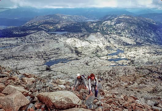 1985, Pyramid Peak, South Lake Tahoe in the distance
|
| Back to top |
|
|
gb
Member

Joined: 01 Jul 2010
Posts: 6310 | TRs | Pics
|
|
gb
Member
|
Mon Aug 30, 2021 3:50 pm |
|
|
The area of Fallen Leaf Lake to Dicks Peak to the Desolation Wilderness, Aloha Lakes, and Pyramid Peak is the best of what the Tahoe area has to offer, at least for outdoor folks.
|
| Back to top |
|
|
Malachai Constant
Member
Joined: 13 Jan 2002
Posts: 16093 | TRs | Pics
Location: Back Again Like A Bad Penny |
ALL CALIFORNIA NATIONAL FOREST CLOSED!
"You do not laugh when you look at the mountains, or when you look at the sea." Lafcadio Hearn
"You do not laugh when you look at the mountains, or when you look at the sea." Lafcadio Hearn
|
| Back to top |
|
|
altasnob
Member
Joined: 29 Aug 2007
Posts: 1408 | TRs | Pics
Location: Tacoma |
|
altasnob
Member
|
Mon Aug 30, 2021 5:20 pm |
|
|
Wow! Seems like a good call with no real rain in the forecast. This is really going to accelerate the CA exodus to the NW.
|
| Back to top |
|
|
moonspots
Happy Curmudgeon

Joined: 03 Feb 2007
Posts: 2456 | TRs | Pics
Location: North Dakota |
|
moonspots
Happy Curmudgeon
|
Mon Aug 30, 2021 5:48 pm |
|
|
| altasnob wrote: | | Wow! Seems like a good call with no real rain in the forecast. This is really going to accelerate the CA exodus to the NW. |
I can see the bumper stickers popping up again (as when I was a kid, ~55 years ago): "Don't Californicate Oregon".
"Out, OUT you demons of Stupidity"! - St Dogbert, patron Saint of Technology
"Out, OUT you demons of Stupidity"! - St Dogbert, patron Saint of Technology
|
| Back to top |
|
|
jinx'sboy
Member
Joined: 30 Jul 2008
Posts: 931 | TRs | Pics
Location: on a great circle route |
As of 7.30 this evening (8/30) additional Evacuations went out for the western parts of Douglas County, Nevada. Im not very familiar with the area there, but it looks like the area northwest of Heavenly Ski Area to US hwy 50 near Stateline.
These Evacuation Warnings will include areas from Highway 50 at Lake Parkway, East to
Elks Point Road (excluding Stateline Casinos) and State Route 207 (Kingsbury Grade) from Highway 50 to Tramway Drive, including all area roads North and South of Kingsbury Grade.
https://inciweb.nwcg.gov/photos/CAENF/2021-08-15-0910-Caldor-Fire/related_files/pict20210730-214908-0.pdf
|
| Back to top |
|
|
treeswarper
Alleged Sockpuppet!
Joined: 25 Dec 2006
Posts: 11279 | TRs | Pics
Location: Don't move here |
|
treeswarper
Alleged Sockpuppet!
|
Tue Aug 31, 2021 7:26 am |
|
|
The Tahoe area has tried to have an active fire prevention program. From the photos, it doesn't look like they had enough acres treated, but that's hard to guess. The drought and high temps have killed a lot of trees in CA making good fuel for fires. The fire will do a good thinning--gotta look on the bright side.
What's especially fun about sock puppets is that you can make each one unique and individual, so that they each have special characters. And they don't have to be humananimals and aliens are great possibilities
What's especially fun about sock puppets is that you can make each one unique and individual, so that they each have special characters. And they don't have to be humananimals and aliens are great possibilities
|
| Back to top |
|
|
altasnob
Member
Joined: 29 Aug 2007
Posts: 1408 | TRs | Pics
Location: Tacoma |
|
altasnob
Member
|
Tue Aug 31, 2021 7:40 am |
|
|
It's a devastating fire but the area at risk in South Lake Tahoe seems to be a prime example of exactly where human beings are not supposed to live. Glancing at the satellite images of the fire I see rows and rows of subdivisions in thick dry forests. Forests that historically burned, and forests that will once again burn. California is exactly what I don't want Washington to become. Hopefully, insurance companies stop offering home insurance for homes in these locations. That is the only way we stop sprawling housing developments through forests lands.
|
| Back to top |
|
|
Sculpin
Member
Joined: 23 Apr 2015
Posts: 1383 | TRs | Pics
|
|
Sculpin
Member
|
Tue Aug 31, 2021 8:11 am |
|
|
Fresh update this morning 8/31 from Zeke Lunder:
https://the-lookout.org/2021/08/31/caldor-fire-8-31-2021/
The fire backed down into the Lake Tahoe valley above Meyers, and jumped across to the Carson Range, where it burned extensively yesterday and overnight. The southern part of the South Lake Tahoe valley is now surrounded by active fire and hundreds of houses have fire out the back door. Red flag through at least tomorrow night.
Puzzlr, that is great shot of the Desolation Wilderness! It is amazing to me that you could pull out an image from 36 years ago. It would take me a week of going through slides. I did a few hikes in there circa 1990.
Your intuition is correct, according to Zeke Lunder. Despite the unprecedentedly bad conditions, wildfire will not burn over the top of the Desolation Wilderness and then down to Tahoe (although since it already flanked around that area and got into the valley, it hardly matters anymore). The Desolation Wilderness is mostly bare, glacier-polished granite. The rock is broken up by areas of loess, where Quercus vaccinifolia forms extensive mats of low brush. This brush is highly adapted to frequent fire because of summer lightning. While the fire has spotted up there and burned brush, there is just no way for the spot fires to spread very far before encountering bare rock.
Between every two pines is a doorway to the new world. - John Muir
Between every two pines is a doorway to the new world. - John Muir
|
| Back to top |
|
|
jinx'sboy
Member
Joined: 30 Jul 2008
Posts: 931 | TRs | Pics
Location: on a great circle route |
| altasnob wrote: | | Hopefully, insurance companies stop offering home insurance for homes in these locations. That is the only way we stop sprawling housing developments through forests lands. |
Agreed.
20 years ago i was at a conference with a couple of insurance industry upper management types.
I asked them, why do you continue to write insurance for people who build in the woods? they just laughed and said, we spend way more paying out claims for drunks and people who burn down their own homes doing stupid things like smoking in bed and leaving the oven on
..fire losses in the forest are a drop in the bucket.
I think things are slowly changing, however. I know people with poorly defensible homes who are being cancelled by their insurers, now. it is the only thing that is going to prompt Counties to change building and zoning codes.
|
| Back to top |
|
|
Malachai Constant
Member
Joined: 13 Jan 2002
Posts: 16093 | TRs | Pics
Location: Back Again Like A Bad Penny |
The Desolation Wilderness is not all bare rock and brush. The Western portion around Pyramid Peak is and down to Aloha Lake which is where the desolation comes from. The Eastern Portion contains many heavily wooded lakes extending down to Tahoe Lake. If the fire gets down to South Lake Tahoe as looks inevitable it will burn upslope to above the PCT. the area up to Baxter Pass is also wooded. We went thru on the PCT a couple years ago. Further north the Trail mostly passes the upper slopes of Ski areas which is pretty bare until you descend to Donner Pass.
"You do not laugh when you look at the mountains, or when you look at the sea." Lafcadio Hearn
"You do not laugh when you look at the mountains, or when you look at the sea." Lafcadio Hearn
|
| Back to top |
|
|
|
|


