| Previous :: Next Topic |
| Author |
Message |
rubywrangler
Member


Joined: 04 Aug 2015
Posts: 511 | TRs | Pics
|
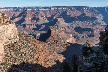
Slow week on the TR forum, so I'll throw in some hikes from the last leg of my road trip. Also if I don't post them here, no one will see the photos except me, my mom, and nancyann  I had seen many incredibly beautiful sights on my hikes through the Sierras, but without a doubt, the highlight of the whole road trip was my first visit to the Grand Canyon. It was mind-blowing. The scale, the colors, everything about it is just staggering! Not having hiked in the desert much (ok ever), I was a little nervous about the water situation, so decided to stick with the beaten path for my first visit. I arrived to the park in the afternoon and went to the Backcountry Info. Center to get a permit. The first few camps I requested were all booked, but I was able to get a permit for Cedar Spring the following night.
The morning was cold and it took me awhile to get out of my cozy CRV bed so I didn't hit the trail until about 9:30am. As I'm sure some of you know, the Bright Angel trail is basically a sidewalk. The good thing about it is, you can pay less attention to your feet and more attention to the views. I passed a bunch of people, though not as many as I was expecting, and made good time to Indian Garden camp. After a snack break I accidentally blew past the intersection with the Tonto trail and made an unplanned side trip to Plateau Point, thus adding another 1.5 miles to my day.
I had seen many incredibly beautiful sights on my hikes through the Sierras, but without a doubt, the highlight of the whole road trip was my first visit to the Grand Canyon. It was mind-blowing. The scale, the colors, everything about it is just staggering! Not having hiked in the desert much (ok ever), I was a little nervous about the water situation, so decided to stick with the beaten path for my first visit. I arrived to the park in the afternoon and went to the Backcountry Info. Center to get a permit. The first few camps I requested were all booked, but I was able to get a permit for Cedar Spring the following night.
The morning was cold and it took me awhile to get out of my cozy CRV bed so I didn't hit the trail until about 9:30am. As I'm sure some of you know, the Bright Angel trail is basically a sidewalk. The good thing about it is, you can pay less attention to your feet and more attention to the views. I passed a bunch of people, though not as many as I was expecting, and made good time to Indian Garden camp. After a snack break I accidentally blew past the intersection with the Tonto trail and made an unplanned side trip to Plateau Point, thus adding another 1.5 miles to my day.
 bright angel trail 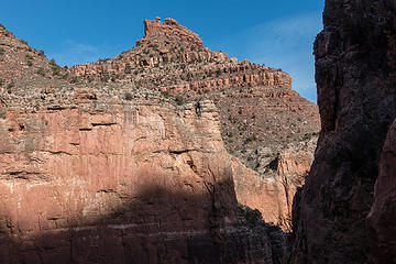 the battleship 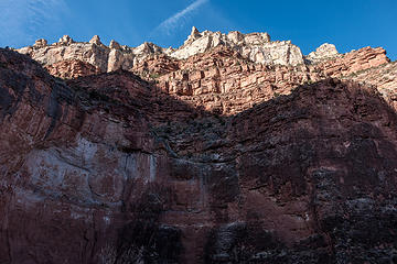 bright angel trail 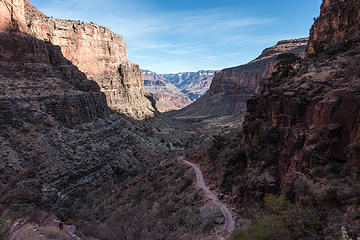 bright angel trail 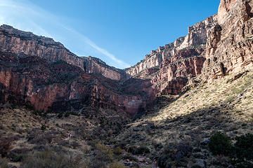 looking back toward the trailhead 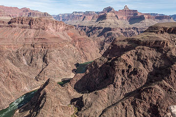 plateau point 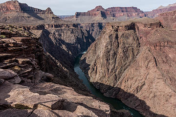 plateau point  ) on my way to Cedar Spring (not radioactive and safe for drinking!!). Although all of the camps I passed were apparently reserved, I only saw a handful of people. It had been overcast for most of the day but the sun peeked through for a bit before sunset. ) on my way to Cedar Spring (not radioactive and safe for drinking!!). Although all of the camps I passed were apparently reserved, I only saw a handful of people. It had been overcast for most of the day but the sun peeked through for a bit before sunset.
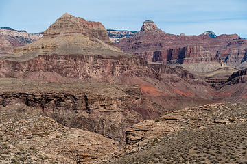 tonto trail 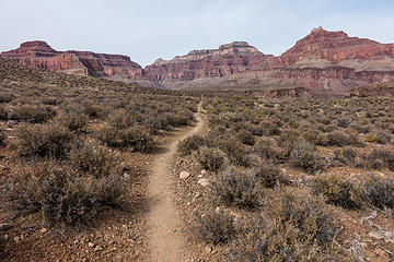 tonto trail 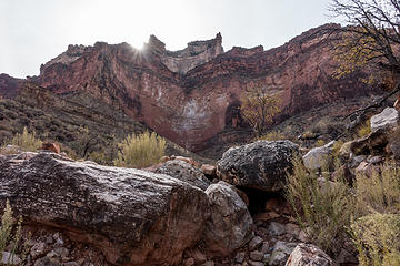 tonto trail 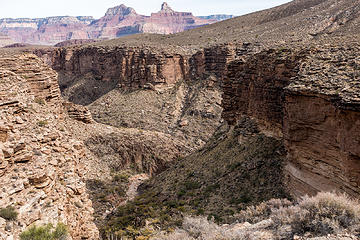 tonto trail 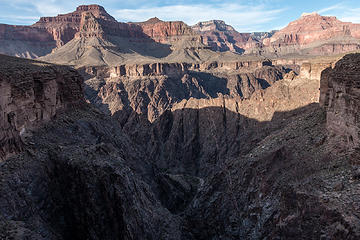 tonto trail  camp view  cedar spring  cedar spring outfall  tower of set 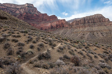 tonto trail 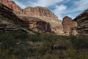 monument creek 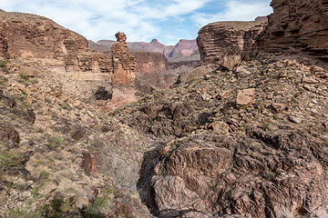 monument creek 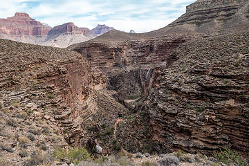 monument creek trail 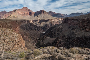 monument creek, granite rapids in the distance 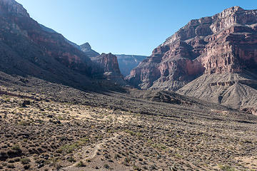 westward on the tonto trail from hermit trail jxn 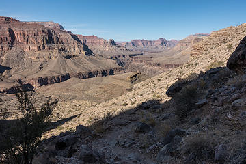 looking back from hermit trail 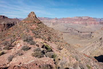 lookout point  hermit creek canyon  lookout point and beyond
|
| Back to top |
  
|
|
Malachai Constant
Member

Joined: 13 Jan 2002
Posts: 16092 | TRs | Pics
Location: Back Again Like A Bad Penny |
Did you visit the cave and cliff dwellings on Horshoe Mesa?
"You do not laugh when you look at the mountains, or when you look at the sea." Lafcadio Hearn
"You do not laugh when you look at the mountains, or when you look at the sea." Lafcadio Hearn
|
| Back to top |
|
|
Eric Hansen
Member

Joined: 23 Mar 2015
Posts: 866 | TRs | Pics
Location: Wisconsin |
Thanks for the TR, pics. Time on the Tonto is where it's at and November and February are prime time. I've done 45 backpack trips in the canyon, and yes it is addictive.
You may want to consider a Grandview to Kaibab trip on your next visit. It's a classic. Undesignated camping allows you to sleep on the rim of the Inner Gorge, enjoy long views and early and late sunlight. And avoid critter/rodent problems of designated and often used campsites.
Seasonal springs are pretty reliable. PM me if you want water notes.
|
| Back to top |
|
|
rubywrangler
Member
Joined: 04 Aug 2015
Posts: 511 | TRs | Pics
|
| Malachai Constant wrote: | | Did you visit the cave and cliff dwellings on Horshoe Mesa? |
No, I didn't know they existed until right now!
| Eric Hansen wrote: | | PM me if you want water notes. |
Thanks, I will!
|
| Back to top |
|
|
Nancyann
Member
Joined: 28 Jul 2013
Posts: 2318 | TRs | Pics
Location: Sultan Basin |
|
Nancyann
Member
|
 Wed Dec 18, 2019 11:24 pm |
|
|
What a great way to finish up your road trip. Glad you did another report on the pics Ive been enjoying.  I have never been in the Grand Canyon, but last April, our pilot flew right over it at sunset on the way back from AZ. My mind was completely blown and I have been conjuring up ideas of visiting it this coming spring!
|
| Back to top |
|
|
Eric Hansen
Member
Joined: 23 Mar 2015
Posts: 866 | TRs | Pics
Location: Wisconsin |
|
| Back to top |
|
|
Nancyann
Member
Joined: 28 Jul 2013
Posts: 2318 | TRs | Pics
Location: Sultan Basin |
|
Nancyann
Member
|
Thu Dec 19, 2019 10:45 am |
|
|
Thanks for the information, Eric. Much appreciated! 
|
| Back to top |
|
|
Malachai Constant
Member
Joined: 13 Jan 2002
Posts: 16092 | TRs | Pics
Location: Back Again Like A Bad Penny |
The cave is called the Cave of the Domes and the Park Service does not publicize it much but allows entry without a permit. Details are available by googling name but I will not put on public forum. The dwelling are kept secret but are also available on web.
"You do not laugh when you look at the mountains, or when you look at the sea." Lafcadio Hearn
"You do not laugh when you look at the mountains, or when you look at the sea." Lafcadio Hearn
|
| Back to top |
|
|
Eric Hansen
Member
Joined: 23 Mar 2015
Posts: 866 | TRs | Pics
Location: Wisconsin |
Edit. I didn't want to discourage if your thoughts were for a (for example) April trip. Just to offer a view of possible odds, flow of traffic and demand, on an early permit approval. And that would be true for the popular, somewhat easy to access trails. Many other areas of the park are difficult to access, and permit applications are easier to obtain for those areas.
During the slow season (mid November to end of February with the exception of holidays) permits for usually popular trails are often available on a walk up basis.
|
| Back to top |
|
|
Malachai Constant
Member
Joined: 13 Jan 2002
Posts: 16092 | TRs | Pics
Location: Back Again Like A Bad Penny |
There are many places on the North Rim which lead to interesting seldom visited areas. Access generally requires long drives on sketchy 4x4 roads which can become impassable if there is heavy rain. The timing is important because too early the roads are in deep snow and too late water is near unavailable.
"You do not laugh when you look at the mountains, or when you look at the sea." Lafcadio Hearn
"You do not laugh when you look at the mountains, or when you look at the sea." Lafcadio Hearn
|
| Back to top |
|
|
geyer
Member

Joined: 23 May 2017
Posts: 463 | TRs | Pics
Location: Seattle |
|
geyer
Member
|
Thu Dec 19, 2019 1:14 pm |
|
|
| rubywrangler wrote: | | Slow week on the TR forum |
Thanks for putting da team on your back
|
| Back to top |
|
|
Sculpin
Member

Joined: 23 Apr 2015
Posts: 1384 | TRs | Pics
|
|
Sculpin
Member
|
Fri Dec 20, 2019 10:14 am |
|
|
Excellent TR, more memories for me.
| Eric Hansen wrote: | | Time on the Tonto is where it's at and November and February are prime time. |
Weather happens of course, but the Tonto at +/-2200', protected from the wind by high canyon walls, can be sublime in the offseason. Unfortunately the upper trails from the south rim were in all-day shade and coated in ice when we did it.
"Horn creek (which I had been warned not to drink due to high uranium level) and Salt creek (which I had not been warned about and drank, but is apparently also radioactive"
I'm kind of a radiation toxicology geek, so this piqued my interest. I did a little sleuthing and came up with this:
https://radwatch.berkeley.edu/blog/grand-canyon-horn-creek
The short summary is the guy measured 23 ppb on the samples he took, which is within drinking water guidelines. The USGS measured levels above the limit up by the mine, but Radwatch puts that in perspective:
"The EPA regulatory limit for drinking water is 30 µg/L [3], or 30 ppb, so in terms of uranium content in this sample, you could drink this water for your entire life!
The concern about Horn Creek stems from samples that are above the EPA limit for drinking water. USGS has measured levels ranging from 18.9 µg/L to 67.8 µg/L, with other samples in the Orphan Mine vicinity as high as 202 µg/L [4]. These concentrations would be a concern if a person was drinking this water over a long period of time (months or years). In the short term, consuming water at any of these levels for 1-2 days would not be a significant risk."
It is more or less inconceivable that backcountry water would have so much radioactivity that drinking from it for a couple days would impact your total radiation budget.
Between every two pines is a doorway to the new world. - John Muir
Between every two pines is a doorway to the new world. - John Muir
|
| Back to top |
|
|
Eric Hansen
Member
Joined: 23 Mar 2015
Posts: 866 | TRs | Pics
Location: Wisconsin |
Sculpin, thanks for the radiation thoughts. I can't remember ever seeing Horn Cr. wet, but Salt Creek is typically flowing in the winter months when I'm there.
And, forgive me, but one correction - Tonto Plateau is not 2,200' but typically 3,700' to 4,000.
Also, thanks for mentioning the deep shade under the south rim (i.e. north slope) and typical winter snow and ice on upper trails, definitely part of the game there in winter. Microspikes and poles are a darn good idea for many trails, and there are some trails with notable exposure such as top of the Grandview and Dripping Springs across the Hermit headwall. Grandview I've done many times, just cautious to remain totally focused. I doubt I'd do Dripping Springs with snow or ice.
So, some challenges and nuance to winter in the Grand Canyon, but bottom line is it is an incredible venue with a wide variety of good choices for routes. And remarkably easy to access via public transportation. Shuttle from Flagstaff (Amtrak) or Phoenix. Check your duffle with the bellhop at the hotel, put on your pack and go.
Also, possible to do multi-week trips with mule resupply at Phantom Ranch (bottom of canyon). 30 pounds, about $70 (up or down). Note the fine print, drop-off at Ranch only.
|
| Back to top |
|
|
Brushbuffalo
Member

Joined: 17 Sep 2015
Posts: 1887 | TRs | Pics
Location: there earlier, here now, somewhere later... Bellingham in between |
| rubywrangler wrote: | | the highlight of the whole road trip was my first visit to the Grand Canyon. It was mind-blowing. |
Right-on thought!
The Grand is widely considered ( correctly I believe*) to be one of the geologic must- see places on Earth.
The scenery 'ain't too bad', either, as your excellent pictures prove!
*I have not seen all of the geologic 'musts' but a lot of them, and the G.C. is surely way up on the list!
Passing rocks and trees like they were standing still
Passing rocks and trees like they were standing still
|
| Back to top |
|
|
Sculpin
Member
Joined: 23 Apr 2015
Posts: 1384 | TRs | Pics
|
|
Sculpin
Member
|
Fri Dec 20, 2019 9:44 pm |
|
|
| Eric Hansen wrote: | | Tonto Plateau is not 2,200' but typically 3,700' to 4,000. |
Oops, that's right. The river is at 2200' but that is not the backpack elevation.
Between every two pines is a doorway to the new world. - John Muir
Between every two pines is a doorway to the new world. - John Muir
|
| Back to top |
|
|
|
|
You cannot post new topics in this forum
You cannot reply to topics in this forum
You cannot edit your posts in this forum
You cannot delete your posts in this forum
You cannot vote in polls in this forum
|
Disclosure: As an Amazon Associate NWHikers.net earns from qualifying purchases when you use our link(s). |


