| Previous :: Next Topic |
| Author |
Message |
Riverside Laker
Member


Joined: 12 Jan 2004
Posts: 2818 | TRs | Pics
|
| Backpacker Joe wrote: | | We don't have to worry about this kind of stuff on the "Best" side. LOL. |
One of the biggest new ditches I've seen was on the east side. A bit past Leroy Basin there was a tremendous event that scoured out a deep ravine on the route to Ice Lakes.
Also seen some giant water events in Death Valley, which gets less than a handful of inches of rain per year. The "road" to Panamint City is a good example. No longer a drive that can be done by buses and trailers, now it's a rugged hike. There's a bunch of vehicles stuck up there, probably for centuries until they fade to dust.
|
| Back to top |
  
|
|
Brushwork
Food truck

Joined: 18 Aug 2018
Posts: 508 | TRs | Pics
Location: Washington |
|
Brushwork
Food truck
|
 Sun Dec 22, 2019 10:22 pm |
|
|
| Riverside Laker wrote: | | One of the biggest new ditches I've seen was on the east side. A bit past Leroy Basin there was a tremendous event that scoured out a deep ravine on the route to Ice Lakes. |
I know the spot. The first time I did it, there wasnt much of a track and it was intimidating. I decided to cross at the upper end. Not a good choice.... next time there was a good enough track across. The rock is so loose and steep its narly without a track. Must have been quite water event to form that. Now it will just get steeper over time.
Oh and thank you HikerJohn and Puzzler. Nice to have some pictures!
When I grow up I wanna play.
When I grow up I wanna play.
|
| Back to top |
|
|
puzzlr
Mid Fork Rocks

Joined: 13 Feb 2007
Posts: 7220 | TRs | Pics
Location: Stuck in the middle |
|
puzzlr
Mid Fork Rocks
|
Mon Dec 23, 2019 10:19 am |
|
|
 Slump area, down another couple of inches
|
| Back to top |
|
|
JPH
Member

Joined: 14 Feb 2008
Posts: 808 | TRs | Pics
|
|
JPH
Member
|
Mon Dec 23, 2019 2:39 pm |
|
|
Do you know if it is allowed to park short of this spot and bike the road?
|
| Back to top |
|
|
bullfrog
Member

Joined: 07 Feb 2007
Posts: 83 | TRs | Pics
Location: Seattle |
|
bullfrog
Member
|
Mon Dec 23, 2019 3:22 pm |
|
|
Thanks HikerJon & puzzlr for the updates. After investing millions in rebuilding the road, it's sad to see this damage already. But since so much time and money has already been put into it, I can't believe that King County/US Forest Service won't fix it.
|
| Back to top |
|
|
Kim Brown
Member
Joined: 13 Jul 2009
Posts: 6899 | TRs | Pics
|
I just watched puzzlr's video.
Looks like the road design did a good job. Those culverts did what they're supposed to do, and kept most of the water off the road. It's not the road's fault the slope is coming down; it's what slopes do.
I wonder if what I see as a well-functioning road is correct, or if I'm full of baloney and the road work failed in some way. The pavement they used is impermeable, so the water rolled off it like it's supposed to, looks like.
"..living on the east side of the Sierra world be ideal - except for harsher winters and the chance of apocalyptic fires burning the whole area."
Bosterson, NWHiker's marketing expert
"..living on the east side of the Sierra world be ideal - except for harsher winters and the chance of apocalyptic fires burning the whole area."
Bosterson, NWHiker's marketing expert
|
| Back to top |
|
|
RichP
Member

Joined: 13 Jul 2006
Posts: 5634 | TRs | Pics
Location: here |
|
RichP
Member
|
Mon Dec 23, 2019 4:26 pm |
|
|
|
| Back to top |
|
|
Windstorm
Member
Joined: 16 Dec 2014
Posts: 288 | TRs | Pics
|
|
| Back to top |
|
|
Brucester
Member
Joined: 02 Jun 2013
Posts: 1102 | TRs | Pics
Location: Greenwood |
Wait, has that made it to the big time? "Stegosaurus Butte Trailhead"
|
| Back to top |
|
|
flatsqwerl
Member
Joined: 23 Feb 2010
Posts: 1049 | TRs | Pics
Location: tacoma |
definitely have some trails to check on now...
|
| Back to top |
|
|
Bluebird
suffering optional

Joined: 22 Jan 2014
Posts: 199 | TRs | Pics
Location: United States |
|
Bluebird
suffering optional
|
Mon Dec 23, 2019 9:43 pm |
|
|
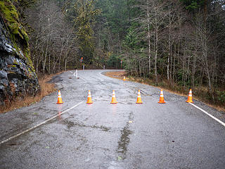
After hiking the mailbox, I decided to check out the road damage. There is plenty of space to park at the barrier, including the CCC road trailhead (the westbound portion), the eastbound portion appears to have been mostly taken out by the slide at the TH.
At first I thought the damage was just what was by the barriers. It looked bad, but not terrible, although some of the holes were pretty deep when I peered into them... but then I noticed trees leaning just around the bend and went for an additional ramble. I found the slide there, with water audibly seeping through and moving across the road and dripping towards the Mfork river. There are also some deep, although narrow, cracks in the road between the two main damage sites.
My take on it is that the water seepage means that the landslide may be moving slowly still. Until that stops, they won't be able to fully assess the road damage. The cracks and deep holes indicate that the whole road bed will need to be repaired.
I uploaded a 3 short videos to Youtube to share.
I also took several photos. Here they are.
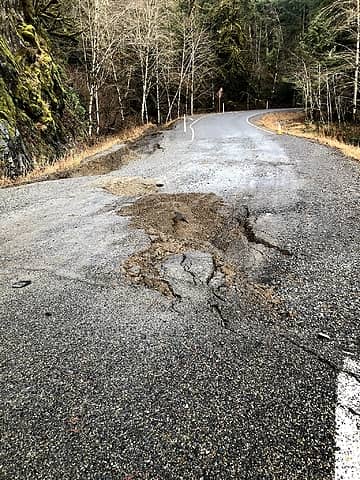 slump area 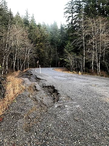 slump area 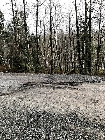 slump area 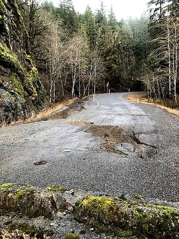 bigger view from the barrier 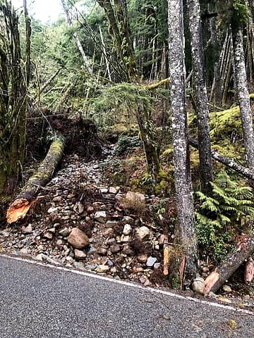 the eastbound CCC trailhead is right next to this...  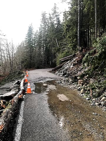 from beyond the slide 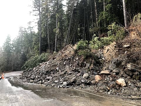 slide 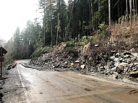 side view of the slide
|
| Back to top |
|
|
Secret Agent Man
Member
Joined: 24 Dec 2015
Posts: 164 | TRs | Pics
Location: Seattle |
| zephyr wrote: | | I reckon those folks (caretakers) at Goldmyer Hot Springs are marooned for the time being. I wonder if anyone else is on the other side of the landslide area. ~z
This is from their webpage--the current access report. Quote:
December 21, 2019:
The road to the Springs is CLOSED until further notice! The County has barricaded the road from 14 miles down from the Springs. There are landslides and trees down and deep water going down the road. Do not attempt trying to access! If you have a reservation for the upcoming week; it will be canceled. You will be called. Be safe!
. |
I cant remember where, but I recall seeing posted somewhere that King County got all the people at Goldmeyer out after the slide. Must have gotten some kind of vehicle up there to do the evacuation.
|
| Back to top |
|
|
BigBrunyon
Member
Joined: 19 Mar 2015
Posts: 1458 | TRs | Pics
Location: the fitness gyms!! |
These slopes are getting shorter with all these landslides these days
|
| Back to top |
|
|
Backpacker Joe
Blind Hiker

Joined: 16 Dec 2001
Posts: 23956 | TRs | Pics
Location: Cle Elum |
I questioned the idea of paving the road all the way to the Taylor bridge before they did it. Now it seems obvious to me it was a mistake. Its going to WAY more difficult to repair the road where needed now that its paved. Think how they will damage the pavement when they have to get all that stuff off the road bed.
"If destruction be our lot we must ourselves be its author and finisher. As a nation of freemen we must live through all time or die by suicide."
Abraham Lincoln
"If destruction be our lot we must ourselves be its author and finisher. As a nation of freemen we must live through all time or die by suicide."
Abraham Lincoln
|
| Back to top |
|
|
Randito
Snarky Member

Joined: 27 Jul 2008
Posts: 9513 | TRs | Pics
Location: Bellevue at the moment. |
|
Randito
Snarky Member
|
Tue Dec 24, 2019 9:24 am |
|
|
| Backpacker Joe wrote: | | I questioned the idea of paving the road all the way to the Taylor bridge before they did it. Now it seems obvious to me it was a mistake. Its going to WAY more difficult to repair the road where needed now that its paved. Think how they will damage the pavement when they have to get all that stuff off the road bed. |
How so? -- if the road hadn't been paved -- this rain event would have still washed out the road.
|
| Back to top |
|
|
|
|


