| Previous :: Next Topic |
| Author |
Message |
Mikey
Member


Joined: 04 Sep 2003
Posts: 737 | TRs | Pics
Location: SW Washington |
|
Mikey
Member
|
 Wed Dec 25, 2019 10:05 am |
|
|
I agree with Mtn Goat that road regulations could use a going over. It has been my experience (yes, I am an engineer and have a PE license but I do not design roads) that government street, road, highway regulations and design standards are politically influenced. In other words, the design is not completely based on good engineering design and construction practice. Once one of the U of W civil engineering graduates gave a talk about his experience working design and construction of I-90 from the floating bridge through Mercer Island. After this WSDOT civil engineer had finished working on the design phase, he was assigned as a WSDOT engineer supervising contractors building this I-90 section through Mercer Island. He said that the original I-90 design had more lanes through Mercer Island but the city of Mercer Island put political pressure resulting in fewer lanes, putting those lids over I-90, and installing special lanes for exit and entrance to Mercer Island. This WSDOT engineer said he repeatedly complained to himself about who was the idiot who did the design, referring to himself. He implied that having experience doing on-site highway construction is very important to a highway design engineer. He was and is a honest civil engineer.
Another example is the Wash. State government repaired the Granite Lakes road after the earthquake (I think that is on Wash. Dept of Nat. Resources land). I asked the contractors doing this project why this road was being repaired when it was rarely used. I was told it was being repaired to use the Federal Govt disaster $ and provide jobs. This road is now a trail. Take a look at the logging roads on private timber lands. I think these private logging roads are built to specifications different from USFS specifications.
|
| Back to top |
  
|
|
Randito
Snarky Member

Joined: 27 Jul 2008
Posts: 9513 | TRs | Pics
Location: Bellevue at the moment. |
|
Randito
Snarky Member
|
Wed Dec 25, 2019 10:24 am |
|
|
The same section of road has washed out a number of times previously. One time was in Feburary of 2006. The road was repaired by early April.
https://cascadeclimbers.com/forum/topic/40135-middle-fork-snoqualmie-washout/
The current washout sounds more severe than the 2006 damage. It will be interesting to see how long it takes for the road to be repaired.
Personally I find the changes (not just the paving) to the Middle fork in recent years to be most welcome. In the late 80's and early 90's the area was unattractive from the activities of gun enthusiasts. Nearly every turn out along the road upstream of the concrete bridge was a shooting gallery with shot up cars, TVs and various garbage used as targets. The sound of gun fire was ubiquitous.
Visiting the lower valley now is far more enjoyable now that target shooting has been banned and actually enforced.
|
| Back to top |
|
|
MtnGoat
Member

Joined: 17 Dec 2001
Posts: 11992 | TRs | Pics
Location: Lyle, WA |
|
MtnGoat
Member
|
Wed Dec 25, 2019 10:24 am |
|
|
| Cyclopath wrote: | | Are you telling us paving the road caused this rain fall? |
Nope. I'm saying that access is not a direct function of spending, because there are other variables such as maintenance levels.
Diplomacy is the art of saying 'Nice doggie' until you can find a rock. - Will Rogers
Diplomacy is the art of saying 'Nice doggie' until you can find a rock. - Will Rogers
|
| Back to top |
|
|
MtnGoat
Member
Joined: 17 Dec 2001
Posts: 11992 | TRs | Pics
Location: Lyle, WA |
|
MtnGoat
Member
|
Wed Dec 25, 2019 10:28 am |
|
|
| RandyHiker wrote: | | Are you a civil engineer? Do you have a PE License?
Or do you just have an expert opinion on everything? |
Not claiming it's an expert opinion.
Then, there's the fact that neither mere accreditation nor licensing is necessarily a standard for actual expertise. I determine expertise by results, not acclaim, accreditation, or proclamation. Those can be hints, but the proof is in the pudding.
The idea you cannot downgrade a road is likely an administrative/bureaucratic decision rather than a scientific one determined by experts.
I don't worship at the altar of credentialism. That religion, without empirical validation and common sense (available to all including the layman, but you have to *choose* to use it), results in all kinds of waste, mistakes, mayhem, and disasters.
Diplomacy is the art of saying 'Nice doggie' until you can find a rock. - Will Rogers
Diplomacy is the art of saying 'Nice doggie' until you can find a rock. - Will Rogers
|
| Back to top |
|
|
MtnGoat
Member
Joined: 17 Dec 2001
Posts: 11992 | TRs | Pics
Location: Lyle, WA |
|
MtnGoat
Member
|
Wed Dec 25, 2019 10:31 am |
|
|
| Kim Brown wrote: | | Access to few people. The Snoqualmie Corridor plan is for access to all. |
Access to anyone who wanted it and chose the means, just like so many other recreations.
In other words, for *all*, merely with the same constraints.
Otherwise, we'd have to conclude boat launches, public airstrips, fishing access, cross country skiing access, and so many other things in which the person chooses the tools to enjoy the resource, are somehow not 'for all' on the basis that not all chose the tools in question.
Diplomacy is the art of saying 'Nice doggie' until you can find a rock. - Will Rogers
Diplomacy is the art of saying 'Nice doggie' until you can find a rock. - Will Rogers
|
| Back to top |
|
|
lopper
off-route

Joined: 22 Jan 2002
Posts: 845 | TRs | Pics
|
|
lopper
off-route
|
Wed Dec 25, 2019 10:32 am |
|
|
The Middle Fk Snoqualmie: the gift that keeps on giving.
Rugged peaks, big waters, poor trails, worse roads.
For those who frequented the area in the 1970s, here is some nostalgia.
This was 2 years before the ever-popular RR flatcar bridge at the Taylor/MFK confluence.
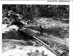 TaylorBridgeJan75 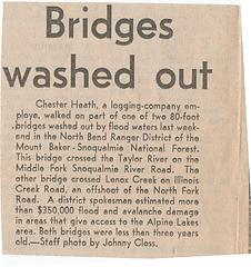 caption
|
| Back to top |
|
|
MtnGoat
Member
Joined: 17 Dec 2001
Posts: 11992 | TRs | Pics
Location: Lyle, WA |
|
MtnGoat
Member
|
Wed Dec 25, 2019 10:36 am |
|
|
So much rain doesn't help!
Diplomacy is the art of saying 'Nice doggie' until you can find a rock. - Will Rogers
Diplomacy is the art of saying 'Nice doggie' until you can find a rock. - Will Rogers
|
| Back to top |
|
|
rossb
Member

Joined: 23 Sep 2002
Posts: 1679 | TRs | Pics
|
|
rossb
Member
|
Wed Dec 25, 2019 10:50 am |
|
|
| Ski wrote: | | I was told that a USFS regulation prohibited them from "downgrading" a road by going from asphalt to gravel. |
So the small gravel section of the lower part of the Mountain Loop has always been gravel? For some reason I think it was pavement at one point. The road to Cascade Pass is a mix -- has it always had the same mix as today?
I think it may be OK to have a section be gravel (like on the Mountain Loop) but maybe you can't transition the entire road.
|
| Back to top |
|
|
MtnGoat
Member
Joined: 17 Dec 2001
Posts: 11992 | TRs | Pics
Location: Lyle, WA |
|
MtnGoat
Member
|
Wed Dec 25, 2019 12:20 pm |
|
|
fix the existing culvert if it's damaged
install new one for the new watercourse
grade and gravel the stretch
leave it gravel for a few years to see what else develops, if anything
keep it simple, cheap, fast, and restore access. Not years/decades of meetings, comments, commissions, studying the studies, etc. 13 years of no fix, and counting for a mile of road here.
Diplomacy is the art of saying 'Nice doggie' until you can find a rock. - Will Rogers
Diplomacy is the art of saying 'Nice doggie' until you can find a rock. - Will Rogers
|
| Back to top |
|
|
Ski
><((((°>

Joined: 28 May 2005
Posts: 12835 | TRs | Pics
Location: tacoma |
|
Ski
><((((°>
|
Wed Dec 25, 2019 2:08 pm |
|
|
| MtnGoat wrote: | | The idea you cannot downgrade a road is likely an administrative/bureaucratic decision rather than a scientific one determined by experts. |
First, to clarify my statement above: that was at least 20 years ago, as I recall. Again, I do not know if that's still an existing regulation or policy.
In the case of the #23 Road washout I mentioned above, the road ran right next to the river.
When the asphalt-surfaced road washed out, all that asphalt was dumped into the mainline Cispus River, which (before the hydroelectric dams were constructed downstream) was a tributary to one of the most productive Class I anadromous salmonid bearing streams in the State, the Cowlitz.
At that point in time, USFS and Tacoma Public Utilities had already spent a lot of money on efforts to restore native fish runs, so the idea of placing more asphalt along a stretch of road that could quite likely be washed out again in the future seemed (to me) like a poor idea at the time.
On that point, the project supervisor was not in disagreement with me, but stated that she had to follow the rule book, and that meant resurfacing that stretch with asphalt.
As things turned out, they installed man-made log structures under the roadbed, similar to what you can see along the Graves Creek Road on the East Fork of the Quinault River, and the last time I checked, the structures had held after a major high-water event.
(Not sure if you can find Jack Galloway's drawings from the Graves Creek planning documents online or not. That particular project was also years ago. I'm not sure if Brenda (project supervisor, Randle RD, GPNF) sent me documents on the Cispus project.)
Whether or not an impermeable asphalt-surfaced road is a better choice than a gravel road (which will be a source of sediment runoff into fish-bearing streams) is a question for highway engineers and fisheries biologists. It's all fine and well for laymen to speculate as to which might be more cost effective, or more expediently installed, but the reality is that they don't always see the larger picture.
"I shall wear white flannel trousers, and walk upon the beach.
I have heard the mermaids singing, each to each."
"I shall wear white flannel trousers, and walk upon the beach.
I have heard the mermaids singing, each to each."
|
| Back to top |
|
|
MtnGoat
Member
Joined: 17 Dec 2001
Posts: 11992 | TRs | Pics
Location: Lyle, WA |
|
MtnGoat
Member
|
Wed Dec 25, 2019 2:25 pm |
|
|
The reality is also that the larger picture is a function of the goals and values applied in determining it.
In this instance, it might involve simply leaving a short section as gravel following a repair.
Diplomacy is the art of saying 'Nice doggie' until you can find a rock. - Will Rogers
Diplomacy is the art of saying 'Nice doggie' until you can find a rock. - Will Rogers
|
| Back to top |
|
|
puzzlr
Mid Fork Rocks

Joined: 13 Feb 2007
Posts: 7220 | TRs | Pics
Location: Stuck in the middle |
|
puzzlr
Mid Fork Rocks
|
Wed Dec 25, 2019 3:23 pm |
|
|
This part of the road was deliberately NOT paved. It has a chip seal surface which is much easier to repair. The engineers knew this part was vulnerable and had a history of slumping. The recent creek diversion has accelerated the movement of the hillside, but there are obvious big slide scarps along the CCC trail that predate the paving. Also, a lot of core drilling was done in this area to learn about what's below and causing the perennial issues.
|
| Back to top |
|
|
Bernardo
Member

Joined: 08 Feb 2010
Posts: 2174 | TRs | Pics
Location: out and about in the world |
|
Bernardo
Member
|
Wed Dec 25, 2019 3:27 pm |
|
|
|
| Back to top |
|
|
MtnGoat
Member
Joined: 17 Dec 2001
Posts: 11992 | TRs | Pics
Location: Lyle, WA |
|
MtnGoat
Member
|
Wed Dec 25, 2019 5:39 pm |
|
|
Good, that should make the repairs faster and cheaper
Diplomacy is the art of saying 'Nice doggie' until you can find a rock. - Will Rogers
Diplomacy is the art of saying 'Nice doggie' until you can find a rock. - Will Rogers
|
| Back to top |
|
|
Kim Brown
Member
Joined: 13 Jul 2009
Posts: 6900 | TRs | Pics
|
| MtnGoat wrote: | | Kim Brown wrote: | | Access to few people. The Snoqualmie Corridor plan is for access to all. |
Access to anyone who wanted it and chose the means, just like so many other recreations.
In other words, for *all*, merely with the same constraints.
Otherwise, we'd have to conclude boat launches, public airstrips, fishing access, cross country skiing access, and so many other things in which the person chooses the tools to enjoy the resource, are somehow not 'for all' on the basis that not all chose the tools in question. |
No, not all uses. All people, regardless of thier abilities, and for all reasonable types of vehicles that are typically used for first visitation as envisioned by the Corridor Plan. A church or retirement community van, school buses for environmental education. Family picnics, hikers. Accessible by reasonable vehicles and reasonable driving skills.
"..living on the east side of the Sierra world be ideal - except for harsher winters and the chance of apocalyptic fires burning the whole area."
Bosterson, NWHiker's marketing expert
"..living on the east side of the Sierra world be ideal - except for harsher winters and the chance of apocalyptic fires burning the whole area."
Bosterson, NWHiker's marketing expert
|
| Back to top |
|
|
|
|
You cannot post new topics in this forum
You cannot reply to topics in this forum
You cannot edit your posts in this forum
You cannot delete your posts in this forum
You cannot vote in polls in this forum
|
Disclosure: As an Amazon Associate NWHikers.net earns from qualifying purchases when you use our link(s). |


