| Previous :: Next Topic |
| Author |
Message |
Man-inna-hillz
Member

Joined: 25 Aug 2005
Posts: 286 | TRs | Pics
Location: Berkeley, CA |
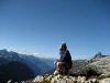
I am planning to once again try to bag Kyes Peak from Blanca Lake trail in late June. I tried this a few years back. I got started much too late. My plan this time is to climb up to Virgin Lake late on a Friday, camp up there, and then get an early start for the long slog.
When I tried it before, however, I had difficulties even with the late start. I found the boot path past Virgin Lake and followed it up for a while, but then got really bogged down in nasty brush. I thought I was doing right by staying to the east side of the crest. Has anyone done this peak bag? Any tips on finding he right route?
The God of language forgives all crimes.
-W.H. Auden
The God of language forgives all crimes.
-W.H. Auden
|
| Back to top |
  
|
|
Schroder
Member

Joined: 26 Oct 2007
Posts: 6722 | TRs | Pics
Location: on the beach |
|
Schroder
Member
|
 Fri Jan 17, 2020 4:18 pm |
|
|
|
| Back to top |
|
|
Bernardo
Member

Joined: 08 Feb 2010
Posts: 2174 | TRs | Pics
Location: out and about in the world |
|
Bernardo
Member
|
Fri Jan 17, 2020 5:32 pm |
|
|
Ask and sometimes ye receive!
|
| Back to top |
|
|
Riverside Laker
Member

Joined: 12 Jan 2004
Posts: 2818 | TRs | Pics
|
The route finding isn't all that bad... IF you don't go up to point 5845. At the saddle south of it, contour on climber's left (west side), then rejoin the ridge where it looks good again. The only semi tricky area is the summit block.
It's a pretty long day. Too bad Virgin Lake isn't much of a campsite.
|
| Back to top |
|
|
Mike Collins
Member

Joined: 18 Dec 2001
Posts: 3097 | TRs | Pics
|
I have day-climbed Kyes three times. My personal write-up says "Beckey's description of the route leads one to think the route is only on one side of the slope. It actually jumps back and forth but stays very close to the actual ridge line. If the way looks scarey back-track and review the path. It is actually a bootscarred route that leaves from the right side of Virgin Lake and is fairly easy to follow. Ice axe will be needed even late in season. The avalanche chute he [Beckey] talks about drops one off on the gentle slope which eventually gets to the true summit. It looks more difficult than it is. I left the car at 06:40 and returned at 15:35."
|
| Back to top |
|
|
MtnGoat
Member

Joined: 17 Dec 2001
Posts: 11992 | TRs | Pics
Location: Lyle, WA |
|
MtnGoat
Member
|
Fri Jan 17, 2020 6:29 pm |
|
|
Kye's is a great climb and yes, the route bounces around the ridge line, doesn't stay on one or the other.
We dodged left after the 1st minor bump before pt 5845, and took the 200'ish loss to use the top of the small basin shown on the map to bypass that point, then sidehilled it over to the gap at 5400'.
Stayed left from there on up, avoiding the chute to the right you can see on the topo (there were tracks from stuff coming down in the chute). The last bit is then just the snowfield slog to the summit. Awesome summit..poke around and you'll find a place which has enough room for one small tent. 
Diplomacy is the art of saying 'Nice doggie' until you can find a rock. - Will Rogers
Diplomacy is the art of saying 'Nice doggie' until you can find a rock. - Will Rogers
|
| Back to top |
|
|
ale_capone
Member
Joined: 22 Sep 2009
Posts: 720 | TRs | Pics
|
Another option in june is to ascend the west ridge from the Columbia glacier.
At this point I'd expect a good snow pack into june, maybe beyond. Lake can be cross able with care. The route is moderate, with some hazzard, but I dont recall it being any worse then the ridge route. Your obviously going to want no avi danger day for either.
Jim dockery posted photos of huge avis up there in the spring.
Blanca lake to Columbia glacier.. leave glacier at about 5400'. You start climbing a north northerly face before getting on the west ridge. Eventually you join the other route on the main ridge. Access depending. I've skinned the whole route to the summit before.
|
| Back to top |
|
|
gb
Member
Joined: 01 Jul 2010
Posts: 6310 | TRs | Pics
|
|
gb
Member
|
Sat Jan 18, 2020 9:58 am |
|
|
I've climbed the NE ridge twice, that is a great route with one unavoidable 80' section of 5.5.
I did the standard route once and found it not that fun because of a long section of pretty steep traversing on knee-high huckleberry bushes. We so much didn't like the south route that we decided to come down the way ale capone just described, and which is obvious from near the summit. You just work down to and across the glacier and then down along the west side of the lake - kind of a bit convoluted along the lake. But then we discovered why Troublesome Creek is so named. It is not crossable in high water and very dangerous. So we waded up to knee deep across about 200' of lake to bypass Troublesome Creek. Still this descent was not a bad route.
|
| Back to top |
|
|
Mike Collins
Member
Joined: 18 Dec 2001
Posts: 3097 | TRs | Pics
|
| ale_capone wrote: | | Lake can be cross able with care |
Thanks for that recommendation. Prudence would dictate a short rope and at least one partner if traversing a lake in late spring.
|
| Back to top |
|
|
ale_capone
Member
Joined: 22 Sep 2009
Posts: 720 | TRs | Pics
|
I also agree with you gb. I've done the s ridge twice as well. North East once and a half. but all moves where snow covered. Love that side, but I swore the first time I wouldn't go back south for the reasons you stated. Jim dockery shares the same view.
I found a photo from june 09. One of the few times I've been up pre july and did not cross the lake. This is probably the steepest section of the route, and viewing up from 5400 where you leave the columbia. Hard to see, but a bear belly slid the whole thing the prior day.
Both from may. You can see most of the route in the three combined.
View from main ridge down west face, turn right.
|
| Back to top |
|
|
Mike Collins
Member
Joined: 18 Dec 2001
Posts: 3097 | TRs | Pics
|
|
| Back to top |
|
|
ale_capone
Member
Joined: 22 Sep 2009
Posts: 720 | TRs | Pics
|
In the original report it said he was found near an inlet stream. Troublesome makes more sense.
|
| Back to top |
|
|
lopper
off-route

Joined: 22 Jan 2002
Posts: 845 | TRs | Pics
|
|
lopper
off-route
|
Sat Jan 18, 2020 1:53 pm |
|
|
I remember the side-hilling on the W side of the ridge was OK, once you get above the last of the brush.
It would be interesting to see how this "ice-walled sidewalk" part of the ridge just below the summit block looks now.
2 pics are from August of 1978.
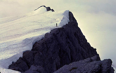 78KyesSouthRdge 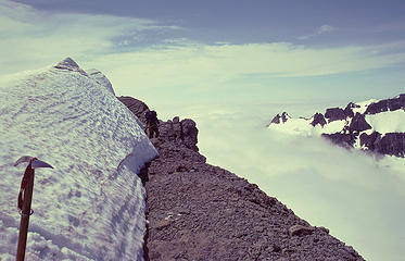 78KyesSidewalk
|
| Back to top |
|
|
Schroder
Member
Joined: 26 Oct 2007
Posts: 6722 | TRs | Pics
Location: on the beach |
|
Schroder
Member
|
Mon Jan 20, 2020 11:59 am |
|
|
A tip for doing any of the Monte Cristo peaks is to do them in May-June with good snow cover. It makes things much easier.
|
| Back to top |
|
|
|
|


