| Previous :: Next Topic |
| Author |
Message |
Jeff
Member


Joined: 18 Aug 2008
Posts: 202 | TRs | Pics
|
 |
Jeff
Member
|
 Tue Jan 21, 2020 3:08 pm |
|
|
|
| Back to top |
  
|
 |
thunderhead
Member


Joined: 14 Oct 2015
Posts: 1519 | TRs | Pics
|
Im pretty sure the winter/return trail to source lake is not included in the touring closure. Just dont skin up in the middle of the return trail. All the dogs wont like it 
|
| Back to top |
  
|
 |
Schroder
Member


Joined: 26 Oct 2007
Posts: 6720 | TRs | Pics
Location: on the beach |
 |
Schroder
Member
|
 Tue Jan 21, 2020 5:28 pm |
|
|
I've always followed the Snow Lake trail and traversed low when it heads up the switchbacks. They used to enforce the ski boundary pretty rigidly in the past.
|
| Back to top |
  
|
 |
gb
Member


Joined: 01 Jul 2010
Posts: 6308 | TRs | Pics
|
 |
gb
Member
|
 Tue Jan 21, 2020 5:31 pm |
|
|
Realize, I'm sure, that things will be deadly this week into Saturday. This should be the biggest avalanche cycle in 4-5 years or so. There will be mountains of debris.
|
| Back to top |
  
|
 |
Randito
Snarky Member


Joined: 27 Jul 2008
Posts: 9512 | TRs | Pics
Location: Bellevue at the moment. |
 |
Randito
Snarky Member
|
 Tue Jan 21, 2020 5:50 pm |
|
|
If you start at the summer trailhead and stay on North side of the creek, you'll completely avoid the Special Use Permit boundary and more importantly will be outside of the blast zone for any snow control operations-- at least under conditions where it would not be insane to head up the Alpental valley.
Under extreme conditions the Alpental ski patrol has bombarded the side of Snoqualmie Mtn with a howitzer. But this is very rare, e.g. 5 feet of snow in two days.
FWIW: There was a report of breakable crust up and over Snow Lake divide from yesterday, so keep expectations in check.
Also check what the NWAC has to say about the snow.
https://www.nwac.us/avalanche-forecast/current/cascade-west-snoqualmie-pass/
|
| Back to top |
  
|
 |
Randito
Snarky Member


Joined: 27 Jul 2008
Posts: 9512 | TRs | Pics
Location: Bellevue at the moment. |
 |
Randito
Snarky Member
|
 Tue Jan 21, 2020 5:56 pm |
|
|
Also Alpental's usual operation schedule is Tuesday through Saturday 8:30AM to 10:00PM Sunday 8:30AM to 5:00PM
|
| Back to top |
  
|
 |
Bedivere
Why Do Witches Burn?


Joined: 25 Jul 2008
Posts: 7464 | TRs | Pics
Location: The Hermitage |
 |
Bedivere
Why Do Witches Burn?
|
 Tue Jan 21, 2020 8:09 pm |
|
|
Hmmm... I can't seem to find a good map that shows the Alpental permit boundary.
Best I can find is this:
It shows the return trail, which is the winter trail to Source Lake, at the edge of the boundary. So is that trail technically inside the boundary and therefore subject to their uphill travel rules?
It's been several years since I've done any touring up there but back when I was going up there regularly, all kinds of people used that trail all the time and I never saw anyone from the resort saying anything about it. We always parked in lot 4 and no one ever said anything about that, either. Have things changed that much in the last 4 years or so?
|
| Back to top |
  
|
 |
Randito
Snarky Member


Joined: 27 Jul 2008
Posts: 9512 | TRs | Pics
Location: Bellevue at the moment. |
 |
Randito
Snarky Member
|
 Tue Jan 21, 2020 8:54 pm |
|
|
| Bedivere wrote: | | So is that trail technically inside the boundary and therefore subject to their uphill travel rules? |
Yes, the Alpental exit trail is within the SUP boundary. More importantly it is within the runout zone for explosive snow control operations conducted by the Alpental ski patrol.
|
| Back to top |
  
|
 |
cascadeclimber
Member


Joined: 04 Sep 2006
Posts: 1427 | TRs | Pics
|
They have repeatedly increased their grabbiness of the SUP and surrounding areas over the years, until The Access Fund or other entity with some clout stepped in.
A few years ago they announced that only people with lift passes could park in any of the lots in winter. This, combined with the Sahale Ski Club's stepped up grabbiness of the roadside near their property meant that there was no public parking anywhere north of I-90 in the winter.
That didn't last long.
I also don't suspect that any attempt to be dickish about who can park where and what side of the creek they can be on would last long either if they delved into heavy-handed enforcement.
|
| Back to top |
  
|
 |
NBSAR
Member


Joined: 06 Aug 2007
Posts: 43 | TRs | Pics
Location: North Bend |
 |
NBSAR
Member
|
 Thu Jan 23, 2020 2:30 pm |
|
|
The uphill travel policy is there, in part, because Patrol may trigger an avalanche that crosses the trail to Source Lake.
As others said, there isn't a safe way into Source lake this week.
Twin Lakes from Hyak might be a good alternative, if you avoid the open slopes above the lakes.
|
| Back to top |
  
|
 |
Bedivere
Why Do Witches Burn?


Joined: 25 Jul 2008
Posts: 7464 | TRs | Pics
Location: The Hermitage |
 |
Bedivere
Why Do Witches Burn?
|
 Thu Jan 23, 2020 5:02 pm |
|
|
| Jeff wrote: | | I guess I was looking for facts about the route and not anyone's opinion on this week's weather. Thanks to those that tried. I'll report back with what I find. |
Was your question not answered? Going by the above discussion - The winter route, which is the return trail, is inside Alpental's permit boundary, right at the edge of it according to the picture I posted. According to Alpental you're not supposed to be there when they aren't open. This is due to hazards associated with avalanche control work.
What exactly they can or will do if you decide to use the trail anyway is kind of anyone's guess at this point.
|
| Back to top |
  
|
 |
Randito
Snarky Member


Joined: 27 Jul 2008
Posts: 9512 | TRs | Pics
Location: Bellevue at the moment. |
 |
Randito
Snarky Member
|
 Thu Jan 23, 2020 5:24 pm |
|
|
The Alpental ski patrol folks have always be friendly and helpful to me -- I usually pop my head in to ski patrol office before heading up. They often provide more detailed snowpack information than what is available from NWAC. It's located in the basement of building on climbers right after you cross the footbridge.
FWIW: On busy weekend days, They request that non-ticket buyers park in the lower lot. https://goo.gl/maps/e975MuYj6SoatdA97 I've never observed any sort of "enforcement" of this request, but if I'm going to check in with ski patrol anyway -- it's not really a big inconvenience to park there and walk up vs parking in Lot 4 and walking down. Plus there are restrooms for disposing of processed coffee.
|
| Back to top |
  
|
 |
Gil
Member


Joined: 29 Sep 2004
Posts: 4062 | TRs | Pics
|
 |
Gil
Member
|
 Mon Jan 27, 2020 6:01 am |
|
|
Stay safe, everyone.
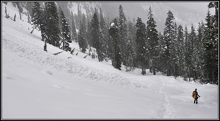
 2009 avalanche below Snow Lake, Washington
Friends help the miles go easier.
Klahini
Friends help the miles go easier.
Klahini
|
| Back to top |
  
|
 |
cascadeclimber
Member


Joined: 04 Sep 2006
Posts: 1427 | TRs | Pics
|
| Gil wrote: | Stay safe, everyone.
 2009 avalanche below Snow Lake, Washington |
That looks like where the summer trail exits the trees and is in an area avoided by using the traditional winter route on the other side of the creek.
However, that side also has two serious avalanche runout zones, one within ten minutes of the end of the cat track. People have died in these places.
The entire basin above Source Lake is dangerous and the ski out from Chair is often an exercise in dodging death cookies in that area.
On top of all of that, the biggest avalanche crown I've ever seen, in person or photographed, was in the Chair Peak basin. We came down the descent route after climbing the North Face and were stuck above the 15-20 foot overhanging crown about 2/3 the way up the basin. We had to traverse far skier's right to find a weakness in the crown to climb down.
In places like this it's important to consider what might be going on with the snowpack *and* people on it high above where you are; the snow in the trees might be stable, but something starting 1000-2000 feet above can easily run into and through the trees and nail a person.3
|
| Back to top |
  
|
 |
Malachai Constant
Member


Joined: 13 Jan 2002
Posts: 16092 | TRs | Pics
Location: Back Again Like A Bad Penny |
Went up there in the spring late 70’s when the two girls and their father were buried under 30’ of snow ice and rocks at the lake on the way to The Tooth. Never went back when snowy. Just too sad and there are so many great places to go.
"You do not laugh when you look at the mountains, or when you look at the sea." Lafcadio Hearn
"You do not laugh when you look at the mountains, or when you look at the sea." Lafcadio Hearn
|
| Back to top |
  
|
 |
|
|