| Previous :: Next Topic |
| Author |
Message |
zephyr
aka friendly hiker


Joined: 21 Jun 2009
Posts: 3370 | TRs | Pics
Location: West Seattle |
|
zephyr
aka friendly hiker
|
 Fri May 29, 2020 3:32 pm |
|
|
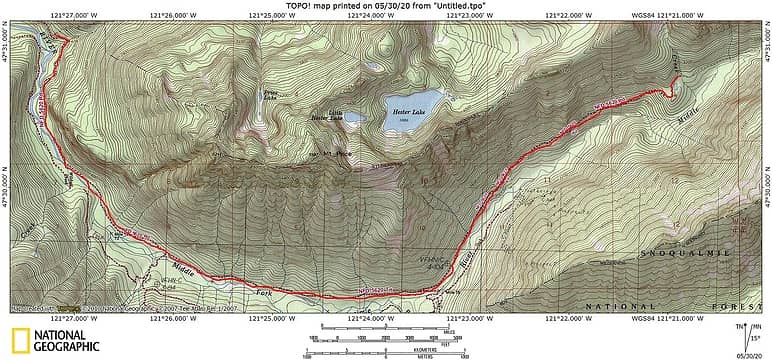
I have been trying to research this but finding incomplete or unclear answers. From the Dingford Creek TH, how far is it to the bridge that crosses Hardscrabble Creek (near the Horse Camp)? I am seeing numbers in the 7 mile range, but it seems much further than that. And this would be the distance along the old road--FS 5620 (also known as the DMG trail) heading to Williams Lake.
Also wondering if a particular website is good for determining distance. The WTA site seems to think that there's only one Hardscrabble Creek--the one in the Teanaways. Thanks, ~z
|
| Back to top |
  
|
|
freshout
Member

Joined: 05 May 2019
Posts: 9 | TRs | Pics
|
|
freshout
Member
|
Fri May 29, 2020 3:39 pm |
|
|
Check out caltopo.com You can measure the distance there.
Edit: I measured it as 7.5 miles if you walk the road from Dingford TH to Hardscrabble Horse Camp. Great swimming spot by there too.
|
| Back to top |
|
|
zephyr
aka friendly hiker
Joined: 21 Jun 2009
Posts: 3370 | TRs | Pics
Location: West Seattle |
|
zephyr
aka friendly hiker
|
Fri May 29, 2020 3:57 pm |
|
|
| freshout wrote: | | Check out caltopo.com You can measure the distance there.
Edit: I measured it as 7.5 miles if you walk the road from Dingford TH to Hardscrabble Horse Camp. Great swimming spot by there too. |
Awesome freshout. I use caltopo for maps, but hadn't tried measuring with it. I did do some "measuring" using Google Maps, but it was pretty tedious. I've give this a shot. Thanks! ~z
|
| Back to top |
|
|
Kim Brown
Member
Joined: 13 Jul 2009
Posts: 6899 | TRs | Pics
|
| zephyr wrote: | | The WTA site seems to think that there's only one Hardscrabble Creek |
Their database is comprised of trail names.
"..living on the east side of the Sierra world be ideal - except for harsher winters and the chance of apocalyptic fires burning the whole area."
Bosterson, NWHiker's marketing expert
"..living on the east side of the Sierra world be ideal - except for harsher winters and the chance of apocalyptic fires burning the whole area."
Bosterson, NWHiker's marketing expert
|
| Back to top |
|
|
zephyr
aka friendly hiker
Joined: 21 Jun 2009
Posts: 3370 | TRs | Pics
Location: West Seattle |
|
zephyr
aka friendly hiker
|
Fri May 29, 2020 9:50 pm |
|
|
| Kim Brown wrote: | | zephyr wrote: | | The WTA site seems to think that there's only one Hardscrabble Creek |
Their database is comprised of trail names. |
Okay. Thanks. That makes sense. ~z
|
| Back to top |
|
|
H. Hound
Member

Joined: 09 May 2003
Posts: 1205 | TRs | Pics
Location: Exit 32 |
|
H. Hound
Member
|
Sat May 30, 2020 5:51 am |
|
|
Tracing it out in TOPO! I got 7.42. So, 7 and a half sounds reasonable.
 DMG
|
| Back to top |
|
|
Brushwork
Food truck
Joined: 18 Aug 2018
Posts: 508 | TRs | Pics
Location: Washington |
|
Brushwork
Food truck
|
Sat May 30, 2020 8:40 am |
|
|
Might be 7 + going in, but per my experience its more coming out. Though it is a nice for a road hike.
When I grow up I wanna play.
When I grow up I wanna play.
|
| Back to top |
|
|
Malachai Constant
Member

Joined: 13 Jan 2002
Posts: 16092 | TRs | Pics
Location: Back Again Like A Bad Penny |
My memory from back in the day is one oil pan + gas tank + 2 flats 
"You do not laugh when you look at the mountains, or when you look at the sea." Lafcadio Hearn
"You do not laugh when you look at the mountains, or when you look at the sea." Lafcadio Hearn
|
| Back to top |
|
|
RatherBOutdoors
Member
Joined: 17 Jun 2017
Posts: 50 | TRs | Pics
|
The Gaia website is usually good for measuring trail distances, too...
|
| Back to top |
|
|
zephyr
aka friendly hiker
Joined: 21 Jun 2009
Posts: 3370 | TRs | Pics
Location: West Seattle |
|
zephyr
aka friendly hiker
|
Sat May 30, 2020 11:09 am |
|
|
Thanks for all the tips. It is a beautiful road with a moderate grade but much to rocky for me and my bike. I had to lock it to a tree after a mile in. I couldn't take the jarring of the cobblestones with a much too heavy day pack. Just below the horse camp I did run into two back country skiers coming down from an attempt on Overcoat. They had bigger bikes, fatter tires, and much younger legs. Then there was even another biker who had gone up to scout a route to a different peak. So it can be done. That detour around the river-filled road was something else--carved into the boggy forest. I even met the guy who does a lot of work on that road. He fixed that big blowout at Garfield Wash. It's currently cross-able at the moment.  ~z ~z
|
| Back to top |
|
|
Bramble_Scramble
Member
Joined: 28 Dec 2012
Posts: 312 | TRs | Pics
|
Zephyr was that you I met about a mile below the end of the road on Thursday? I was pushing my bike up the hill and have a white helmet.
|
| Back to top |
|
|
zephyr
aka friendly hiker
Joined: 21 Jun 2009
Posts: 3370 | TRs | Pics
Location: West Seattle |
|
zephyr
aka friendly hiker
|
Sat May 30, 2020 4:29 pm |
|
|
| Bramble_Scramble wrote: | | Zephyr was that you I met about a mile below the end of the road on Thursday? I was pushing my bike up the hill and have a white helmet. |
Wow. Yes, it would have to be I should think. You were coming uphill on a bike and I was heading down the road. We chatted briefly, then you headed back up and I continued my painful slog down. haha. Then you later passed me while I was talking with the guy in the quad. That's the guy who repaired FS 5620 with his crew. He fixed that section where it was "chest deep" and made it more passable.
We've been talking already across two other previous threads. Glad to have met you. I couldn't remember which mountain you were reconnoitering. I hope the info you got ahead of time was useful. ~z
|
| Back to top |
|
|
Bramble_Scramble
Member
Joined: 28 Dec 2012
Posts: 312 | TRs | Pics
|
Nice to meet you! I was checking out how long it took me to ride/push to the trailhead because I want to do Big Snow this summer. I missed the fisherman's trail because I was looking in the wrong spot. I did find out that it will definitely need to be an overnight if I want to go that way instead of the Myrtle Lake approach. I couldn't find the heavy machinery I was looking for but wasn't really sure where to look. Someone, maybe Puzzlr, had a picture of it in a thread on here.
I just got my bike in February so I'm a bit of a noob but I was able to ride the three miles from the road end to Goldmyer junction in about 20 minutes. I was on the brakes the whole time but made it without issue. I wanted to poke around a little more at the road end but I was afraid I wasn't going to have enough time to get back before dark. I wish I had looked around more because it only took 2hr 20 minutes to get back to car at the top of "Hell Hill" vs 4hr 30 minutes (with breaks) heading in.
I definitely could have driven in a ways farther or at least parked at the bottom of "Hell Hill" to make things a bit easier. My car has about as much ground clearance as the Toyota Matrix at the trailhead but the Matrix probably had four wheel drive so who knows.
I'm assuming the guy in the side by side is a crystal mine owner? I saw the trails to Purple Hope and the trail/supplies for the Spruce Mine. There was also the white van parked but I'm not sure what property he was there for. I didn't see any trails near it and the closest mine I could see near there is Crestview and I thought it was on the south side of the river.
Also I checked 100 Hikes and Dutch Miller Gap is about 15 miles rt from the road end so it would be a pretty tough day hike. If I could park at Dingford I might be able to do it but it would take a lot of time and effort. Probably better to overnight. Also if you have a bike it's probably more enjoyable from this side instead of the hot, dry Waptus side.
|
| Back to top |
|
|
zephyr
aka friendly hiker
Joined: 21 Jun 2009
Posts: 3370 | TRs | Pics
Location: West Seattle |
|
zephyr
aka friendly hiker
|
Sun May 31, 2020 2:06 pm |
|
|
| Bramble_Scramble wrote: | | I'm assuming the guy in the side by side is a crystal mine owner? I saw the trails to Purple Hope and the trail/supplies for the Spruce Mine. There was also the white van parked but I'm not sure what property he was there for. I didn't see any trails near it and the closest mine I could see near there is Crestview and I thought it was on the south side of the river. |
You made good time on that bike. I would definitely need a newer bike with better shocks and tires and not carry so much weight to try it again.
The guy I talked to may have been a property owner up there, but I didn't ask. He definitely knew a lot about the local history and had worked a lot on the road. I wanted to learn as much as I could, but I still was 2-3 miles from Dingford and I to retrieve my bike, get to my truck, and cross those washouts in daylight. While driving back toward Taylor River I kept an eye out for you. But hearing your times on the return, you would have been long gone. ~z
|
| Back to top |
|
|
Bramble_Scramble
Member
Joined: 28 Dec 2012
Posts: 312 | TRs | Pics
|
| zephyr wrote: | | You made good time on that bike. I would definitely need a newer bike with better shocks and tires and not carry so much weight to try it again.
The guy I talked to may have been a property owner up there, but I didn't ask. He definitely knew a lot about the local history and had worked a lot on the road. I wanted to learn as much as I could, but I still was 2-3 miles from Dingford and I to retrieve my bike, get to my truck, and cross those washouts in daylight. While driving back toward Taylor River I kept an eye out for you. But hearing your times on the return, you would have been long gone. ~z
.
. |
As far as I know the only people with keys are property owners. I would have enjoyed talking to one of the mine owners but I was really worried about getting back before dark. After I passed you I was sort of trying to race you to see if I could get back to my car and leave before you came by. It was faster but I still would rather drive to Dingleford than ride the extra 5.5 miles each way. I was being pretty cautious considering I went over the handlebars and cracked a rib a few weeks ago after I saw those bears on the Mountain Loop.
I'm thinking I might try to drive further down the road in the next couple days and maybe try to get to lower Hardscrabble Lake or hike up the Middle Fork from the end of the road. Either that or bike down Taylor River and hike up to Snoqualmie Lake. There's still quite a bit of snow up high. From satellite imagery it looks like snow on the Middle Fork trail starts after Crawford Creek.
I hope to run into you again sometime!
Edit: Here's the heavy machinery I was looking for https://www.nwhikers.net/forums/viewtopic.php?t=7993742
|
| Back to top |
|
|
|
|


