archer and i wanted to go on a hike and first selected Huckleberry Mtn off Suiattle River. I investigated more and learned that there were two routes and as a lakebagger, i pushed for the one with lakes on the way.
Tenas road is unsigned & ok for any car but the brush scraped the car. The trailhead for Boulder Lake is also unsigned but it was the only trail there, so off we went! The first mile had some significant mud that i recommend boots for. We passed a gorgeous set of waterfalls
and then topped into the upper valley near a lazy stream
before climbing again to contour around avalanche swaths that still had mounds of snow.
around 4600 the trail is harder to find among boulders slide alder snow and tenas creek.
we knew the basic route so continued up. with the creek running high and snow bridges across it, i decided we would just go up the outlet rather than try to cross as the trail route does.
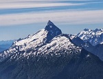
a short brush bash, mossy talus scramble and snowfield brought us to lake outlet 1 with stunning views of hurricane peak. and our first real obstacle: a steep snowfield with big melt holes that was the only way to continue towards the benchmark. i put on my mountaineering boots, the light aluminum crampons i didnt think id need and pulled out my axe. maybe today hadnt been the day to go hike in a miniskirt?
i offered to investigate and found a way up between the holes that was solid enough, although a couple short sections had 50 degree snow. archer had never climbed steep snow but i encouraged her to try, and soon we topped off.
we continued on continuous snow to the second lake outlet and then uphill again along the ridge. we found steep snow, moderate snow, scrambly forest connection bits and some rock. it was pretty adventurous in these conditions but the snow conditions were really quite good
Some of the sections had runout issues so we used extra care in them. The summit ridge had some big cornices to avoid. i wondered what wed find on the true summit.
Melted out grass! a gorgeous summit. We enjoyed intermittent views among the clouds for a long break. we had expended a lot of energy and time ascending5.5 hours from the trailhead with the route finding and photo breaks. it was 5:30 when we left the summit.
we carefully retraced our steps and i found ways around some of the the steep snow. There was evidence of a camp fire as well as recent footprints at the outlet where the trail ends. we considered going down that way but the plan was for handstand photos at the other outlet so we continued. at the top of the steep snow we paused but there definitely was no easier way to the outlet. i explained face in downclimb techniques and made sure to create a good ladder down. we enjoyed the outlet with some handstands and then bushwhacked to the tarn at tenas creek before the mosquitoes found us. ah, evening. the hike out was uneventful and we didnt need headlamps.
(sorry if this isnt the best formatted! i am using my phone!) total stats 3500 gain 7.5 miles rt
That must be a 'first' at Boulder Lake!
My son and I used to fish there and were shocked one time to see that someone had packed in a 14' canoe, possibly another first.
( the route is much easier in mid summer)
Passing rocks and trees like they were standing still
0
Passing rocks and trees like they were standing still
it is a short hike but a 14 foot canoe? wow! archer did handstands at each lake outlet and on the summit, suspect youre right that is a first time for each location 😂🏔😍😘
You cannot post new topics in this forum You cannot reply to topics in this forum You cannot edit your posts in this forum You cannot delete your posts in this forum You cannot vote in polls in this forum
Disclosure: As an Amazon Associate NWHikers.net earns from qualifying purchases when you use our link(s).