Forum Index > Trip Reports > Wyoming 13ers Slam 2020 Part 2 of 5 - Wind River and Francs Peaks July 15 & 18, 2020
 Reply to topic
Previous :: Next Topic
Author Message
Matt Lemke
High on the Outdoors


Joined: 15 Jul 2010
Posts: 2052 | TRs | Pics
Location: Grand Junction
Matt Lemke
High on the Outdoors
PostSun Aug 09, 2020 9:29 pm 
Wind River Peak - South Slopes - July 15, 2020 After a nice rest in Riverton at the motel, I decided to take a couple days and do some planning before moving on to Wind River Peak. I drove up to one of my favorite towns ever; Cody and stopped in at Sunlight Sports to buy some more gear in preparation for the big Wind River Trip. I got a new ultralight insulation coat as well as some Nuun hydration tablets and a new pair of shoes (that I didn't end up using but finding shoes big enough for me is extremely rare so I bought them anyways). I took my Lowa Renegade hiking boots to a cobbler across the street to have some stitches added where they were starting to come undone (these are the shoes I did the vast majority of the trip in). Unfortunately though the outdoor store in Cody did not have aluminum crampons, which I was going to need to ascend the many snowfields in the Winds when they would be super firm in the mornings. So I ordered a pair of Camp strap-on aluminum crampons from the Bozeman REI and had them rush shipped to my friends house in Cody, which I would pick up after hiking Wind River Peak. On the afternoon of the 14th, I drove back down to Lander and had a great burger at the Gannett Bar and Grill (Wyoming is so awesome, all the bars, resturants and breweries are all still open), and drove down to South Pass on Wyoming Highway 28. Just a few miles west of the pass itself, I turned right (northwest) onto the Lander Cutoff Road (AKA Big Sandy Road). This is the super long gravel road traversing to the southwest of the Winds, and provides access to the Big Sandy Trailhead (one of the main trailheads for the range). After something like 15 miles from the highway (estimate) I turned right onto the Sweetwater Gap Road. After a few miles there are two options for approaching Wind River Peak from the south. The main way is to drive past the Sweetwater Guard Station to the Sweetwater Trailhead at the end of FS 890. A nice trail leads to Little Sandy Lake from here, but requires an additional 1200 feet of elevation gain to hike over the divide through a pass, and then descends 800 feet to the lake...all overkill. I decided to take the road leading to Block and Tackle Hill on FS 889 slightly to the west, which is an unofficial trailhead (called Little Sandy Trailhead on Google Maps) that would not require me to ascend 2000 feet of additional gain round trip. The only downside of this route however is that the road becomes high clearance 4WD as soon as you cross the national forest boundary. I was able to drive my 2WD stationwagon to a spot about halfway between the NF boundary and the steepest part of the road up Block and Tackle Hill where I parked and gave up. I slept for a short night with the alarm set for 2:30am.
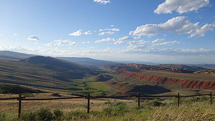
View on Highway 28 to South Pass
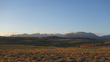
Sunset on the southern Winds
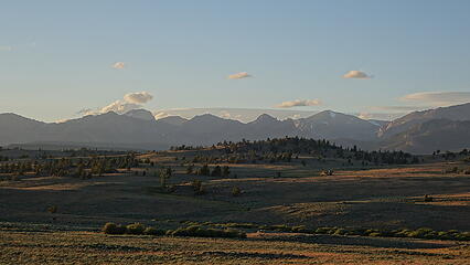
Evening light on a distant Wind River Peak
I awoke and was ready to go. In 10 minutes I started hiking up the road, and made quick work getting up the hill, which was indeed very rough, and only passable with real 4WD vehicles. To my dismay though, the entire rest of the road past the hill was 2WD compatible! I cut some of the road walking off by walking cross country to the north, and cutting off the long loop the road makes off to the west. Without too much energy spent, I made it to the end of the road shortly after 3am and started up the Little Sandy Trail which was in great condition. Old reports on Summitpost state this trail is abandoned but that is not true, and it was easy to follow even in the dark. It was easy going and soon enough I hit a rail junction, where the trail from the Sweetwater Trailhead coming down from the pass to the east intersected. This trail actually appeared to be the lesser used. A few minutes past that junction was another signed junction, with a sign indicating Little Sandy Lake pointing to the right. I continued left as the trail ascended some steeper more open terrain on the rocky slopes above and west of the lake. The main trail never actually got a good view of Little Sandy Lake. After some useless up and downs, the trail passed a smaller unnamed lake on the left at 9800 feet, then made a short descent into a big flat meadow upstream of Little Sandy Lake. Other than a couple small swampy sections this went super quick until the valley made a slight jog to the west. At 10,000 feet elevation I left the trail, crossed Little Sandy Creek (I made another log bridge) and started up the 800 foot ascent up steep boulders towards Coon Pass. When I was just a couple hundred feet above the creek the sun rose.
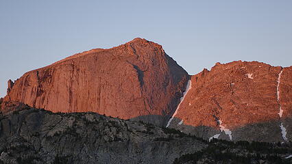
Sunrise on unnamed cliffs on the west side of the Little Sandy Gorge
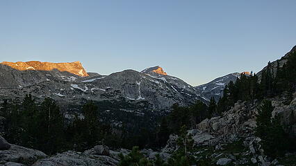
View looking north up Little Sandy Gorge from the route to Coon Pass
I eventually reached Coon Pass which ended up only having a couple short 3rd class spots and descended to Coon Lake, walking around its south side. The sunrise lighting and reflections from this lake were stunning. Instead of continuing on the trail which descended a long ways, I cut left and rounded the broad ridge that extends south from Tayo Lake. Just a short spot of easy schwacking through short trees and a little bit of boulder hopping and I was on my way to intersecting the trail heading up to Tayo Lake. Upon reaching this grand lake, my view opened up substantially. The gentle south slopes of Wind River Peak were visible to the right, with a beautiful serrated ridge of towers separating the Tayo Lake basin from the Little Sandy Gorge to the west. It was as I rounded the eastern shore of Tayo Lake I had my first mosquitos of the day so I Deeted up and started up the grassy gentle slopes towards Wind River Peak.
Coon Lake
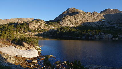
Coon Lake
Reflection in Coon Lake outflow
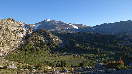
Wind River Peak and the stream draining Tayo Lake from the broad ridge
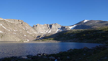
Tayo Lake
Tayo Lake
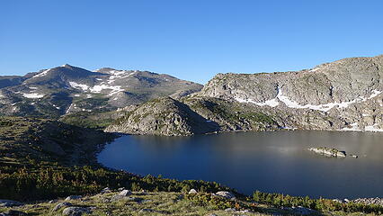
Ascending above Tayo Lake
All in all, it was an extremely easy walk to the summit of Wind River Peak, avoiding the only snowfield I saw to the left side and boulder hopping the upper 750 feet. The summit was a large flat plateau roughly the size of a football field with the highest point towards the north end, which terminated at a very steep 1000 foot drop on the north face. It's almost as if the peak was cut in half and I was reminded of Half Peak in Colorado that I had just hiked up in June. I had service on the summit and was able to chat with a few friends (I would go on to find 4G on every Wyoming 13er I did except for 2 of them). The view was spectacular. The Cirque of the Towers with Pingora and Wolfs Head, along with countless other beautiful sweeping granite faces surrounded me in every direction, all of which were substantially lower than the perch I stood on. A high 12er to the west caught my eye, which I looked on the map to find it was called Temple Peak, and is the third highest 12er in Wyoming at 12,972 feet (just 6 feet lower than Woosley that I described earlier).
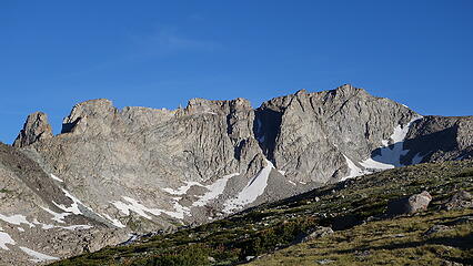
Rugged cliffs at the head of the valley above Tayo Lake
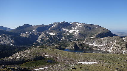
Looking down the gentle south slopes
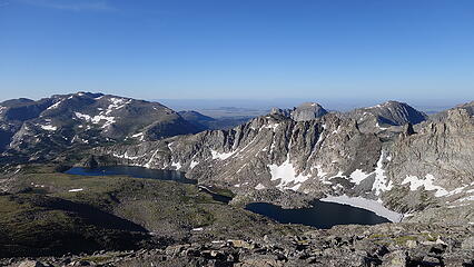
Tayo Lake below
Tayo Lake below
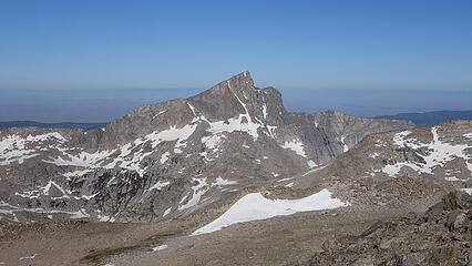
Temple Peak to the west
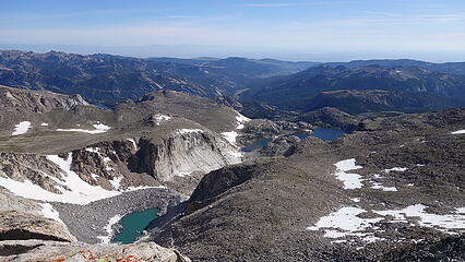
Deep Creek basin to the northeast from the summit
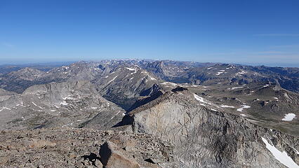
The cirque visible below looking north
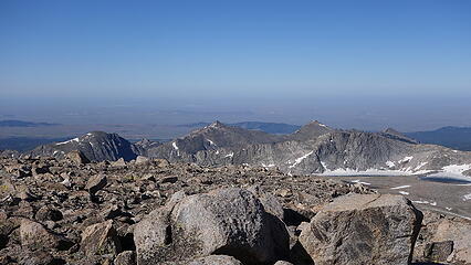
View south from the summit
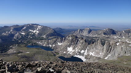
Tayo Lake from the summit
I had an uneventful hike back, retracing my steps and making the long walk back. On the return trip, I made a small detour on the little side trail that led right to Little Sandy Lake, and just before reaching the lake, I heard something big gallop into the water and make a huge splash. As I got to the lakeshore, I saw a bull moose swimming towards the center of the lake. I guess I spooked him, however I had no idea moose could even swim! That was a cool sight to see. The rest of the hike out was again hot and dry. This day was the 6th day in a row with no thunderstorms or even many clouds to speak of in all of Wyoming, and no end in sight to the clear, hot weather. I was wishing Eric and I could already be in the Winds since we would be able to knock so much out being able to utilize the full days, but I knew he really wanted to finish the Centennials and last I spoke with him, he was pulling all nighters continually bagging peaks for days on end with not much more than 1-2 hour naps between each one to try and finish by the 20th. Once back at my car, I went back to the cheap $50 motel in Riverton for another shower and a bed. This was a long day climb, and came out with a round trip total of about 28 miles!
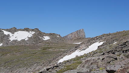
Temple Peak poking above the ridge as I descend
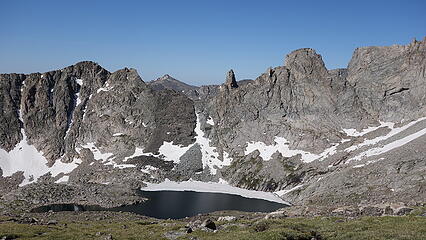
Steep tower above Tayo Lake
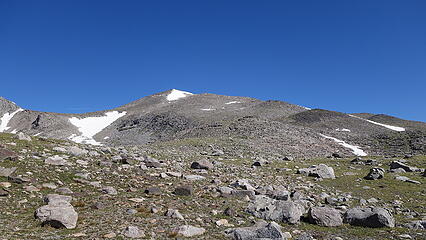
Looking back at Wind River Peak
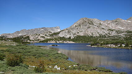
Coon Lake
Coon Lake
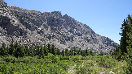
Back on the trail in Little Sandy Gorge
Francs Peak - Meadow Creek Route - July 18, 2020 I took a couple days off and rested in Cody, hanging out with a few old friends who still lived there who I hadn't seen in many years (dating back to the days I lived in Red Lodge and Bozeman!) I was thrilled to be able to catch up with them. Francs Peak is an easy peak in the Wyoming Absarokas, and the only 13er in the volcanic and non fault block mountains of Wyoming. Of all the 13ers, this one is the easiest, and shortest, only requiring a half day trip for fast hikers, or a full day for more leisuraly walkers. Without a 4WD high clearance vehicle, the shortest route is via the Meadow Creek Route, which starts at the Meadow Creek Trailhead on Wood River Road (FS 200). It's a long drive on gravel roads to this point, but from the town of Meeteetse, I turned southwest onto Pitchfork Road (Highway 290) and just before reaching the Lower Sunshine Reservoir, I turned south onto the Wood River Road and followed it for a long ways towards Kirwin. The Meadow Creek Trailhead is on the right at 8400 feet elevation a few mines before Kirwin. There are two stream crossings that you must drive through that will not be possible in 2WD cars before early July (the road fords Wood River twice in the last couple miles just before reaching the Meadow Creek Trailhead). When I was there on July 18th, I barely made it through them in my stationwagon (2WD with more clearance than the average car but not as much as an SUV). If you cannot cross these streams, it's only an additional 1.5 miles or so road walk each way. I started up the Meadow Creek trail shortly after sunrise to the sound of dozens of people along the Wood River with chain saws cutting up logs and thinning the forest. As I hiked up the initial 400 feet up and out of the Wood River Valley, the switchbacks on the trail were insanely obnoxious, but at 8800 feet the trail started a more straight path and followed the left side of Meadow Creek. Francs Peak is nutorious for grizzle bears, more so than any other 13er in Wyoming and it's not uncommon for people to see dozens of them. Because of this, I borrowed a can of bear speay from a friend in Cody, which was the only peak I even brought bear protection for (grizzlies have nearly completely evacuated both the Wind River and Bighorn Ranges for terrain further north in Montana and Canada). As I neared treeline, I entered a gorgeous meadow (big surprise!) and passed by a few people camping. I continued up the trail as it followed the left southern fork of the upper basin. I filled up water and left the trail just before it turned sharply south and made an ascending traverse northwestward to the very broad ridge. From there I went up and over a small hill and descended a couple hundred feet aiming for the base of the SE ridge of Francs Peak. The terrain through here was incredibly gentle and flat. I passed by a lone grizzly bear well off to my right who barely even noticed me. I did see a lot of evidence of grizzlys on the ridge, and even all the way up towards the summit as well! Both grizzly prints, and made holes and rocks overturned as they look to eat the moths and bugs that hide under them. Just as I was reaching the summit another solo hiker was coming down and he mentioned that he scared away 15 grizzly bears around the summit just before I arrived eek.gif I had heard what I thought was someone yellong above me but couldn't figure out what it was until he mentioned that. Given how calm and warm it was once again, I sat on the summit by myself for a half hour enjoying the view. All these Absaroka Peaks are all ones I have never seen or climbed before, but every one of them looked class 2. Certainly gentle giants. I was back at the car just a bit after noon after a quick descent for a nice half day stroll up Wyomings easiest 13er.
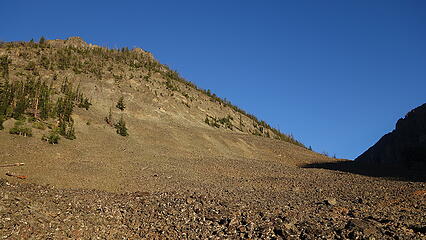
Bunch of talus just above the initial switchbacks
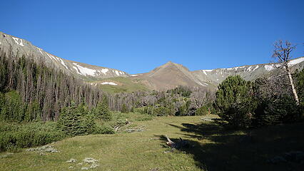
Nearing the Meadow Creek Meadow
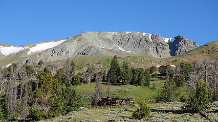
Looking up to the ridgecrest above
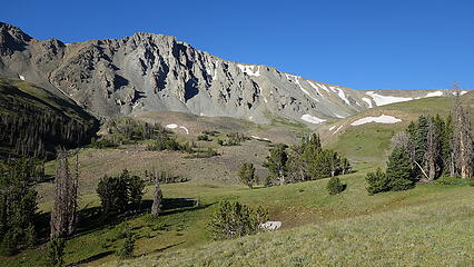
View up the southern fork where the trail continues above treeline
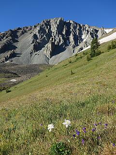
Lots of wildflowers out
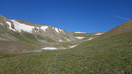
Easy walking to the ridge from here
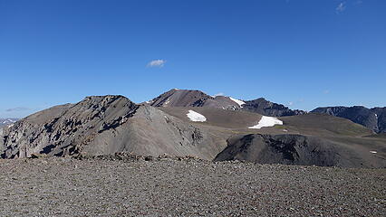
On the broad ridgecrest looking towards Francs
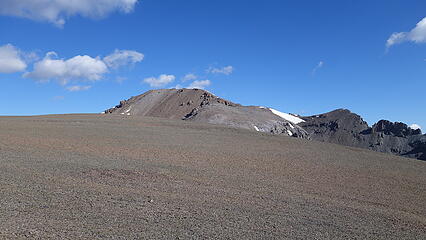
Moonscape
Moonscape
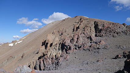
Ascending the SE ridge
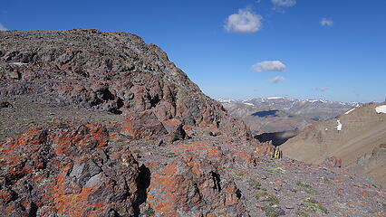
Weird volcanic formations
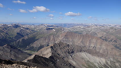
Summit view
Summit view
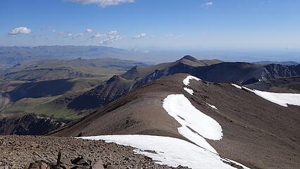
View down the NE ridge (with a 4WD you can ascend this ridge from a start elevation of 11,030 feet!)
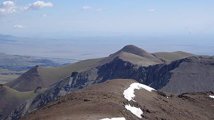
Point 12,520 on the NE Ridge
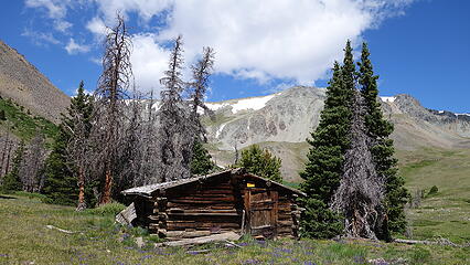
Old cabin at the Meadow Creek Meadow
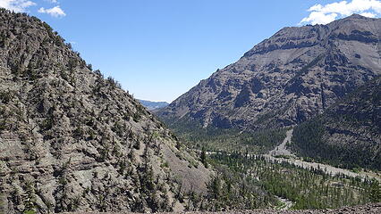
Descending the switchbacks back to Wood River
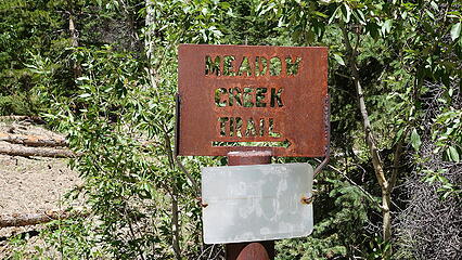
Meadow Creek TH sign
Next up, I'll begin describing the meat of the trip, and write about the first of 3 parts as we venture into the core Wind River Range for two weeks!

The Pacific coast to the Great Plains = my playground!!! SummitPost Profile See my website at: http://www.lemkeclimbs.com
Back to top Reply to topic Reply with quote Send private message
Songs2
Member
Member


Joined: 21 Mar 2016
Posts: 200 | TRs | Pics
Songs2
Member
PostMon Aug 10, 2020 5:59 am 
Thanks for this multipartite trip report. Although the adventures are way above my level, I hope to get some experience in the Winds and Absaroka Range on an upcoming first trip to Greater Yellowstone Ecosystem and surrounding areas. This is great info, and wonderful photos. Looks like you had a solid run of bluebird days!

Back to top Reply to topic Reply with quote Send private message
   All times are GMT - 8 Hours
 Reply to topic
Forum Index > Trip Reports > Wyoming 13ers Slam 2020 Part 2 of 5 - Wind River and Francs Peaks July 15 & 18, 2020
Jump to:   
Search this topic:

You cannot post new topics in this forum
You cannot reply to topics in this forum
You cannot edit your posts in this forum
You cannot delete your posts in this forum
You cannot vote in polls in this forum