| Previous :: Next Topic |
| Author |
Message |
Alden Ryno
Member

Joined: 04 Jun 2019
Posts: 150 | TRs | Pics
Location: Issaquah, WA |
Dome and Sinister Peaks, 08/13-15/2020
Stats: 48 miles, 14,000' gain.
Trailhead: Downey Creek.
Routes: Standard Dome Glacier for Dome, southern crossing of Dome to approach Sinister.
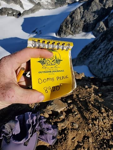
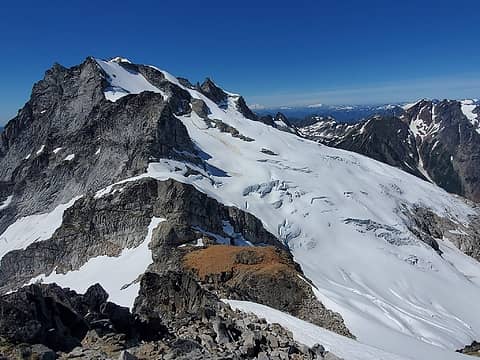 Dome from Sinister 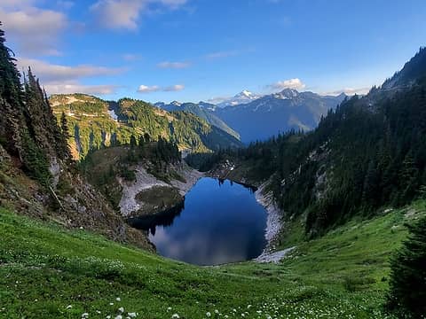 Nearly 14 miles in, according my my GPS. 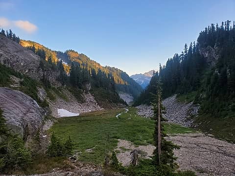 Over the direction of Itswoot Lake from Camp 1 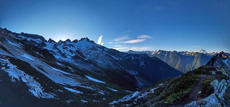 Itswoot Ridge Pano 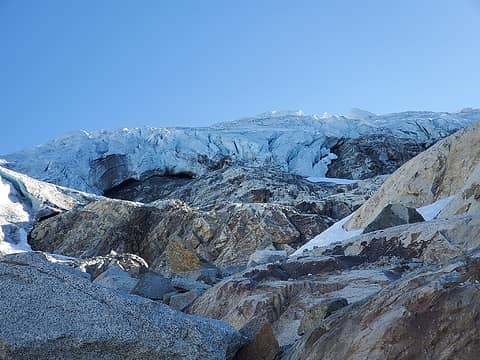 Beneath the Dome Glacier. According to maps, I was standing on it 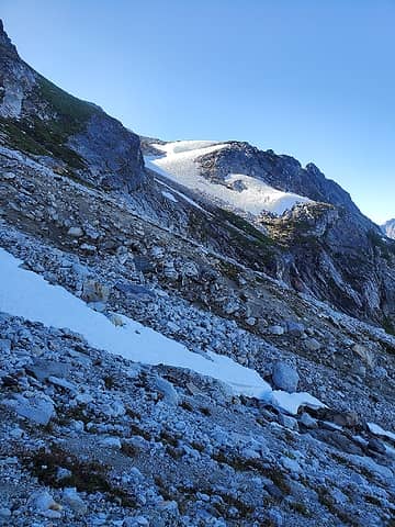 Ramp to get out of first basin beneath Dome Glacier 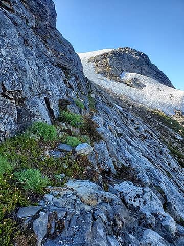 Grassy ledge 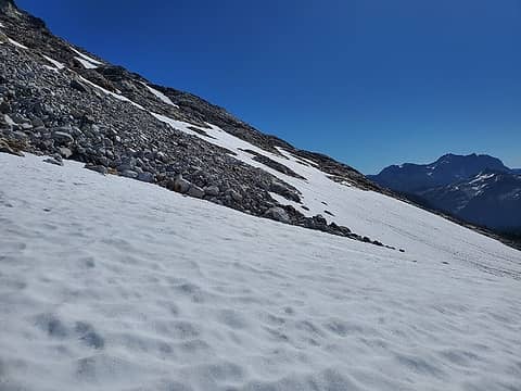 Easy traverse terrain in the second basin. En route along 7,000' contour 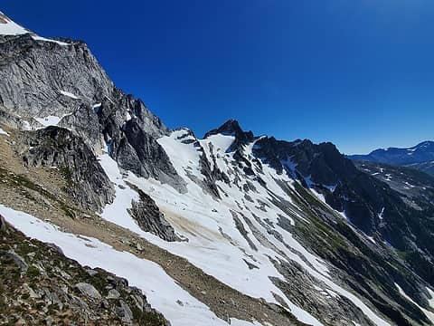 Sinister sighted 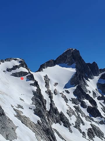 Snow finger I chose. Ledges provided easy access once gained. The finger above mine is the proper choice. 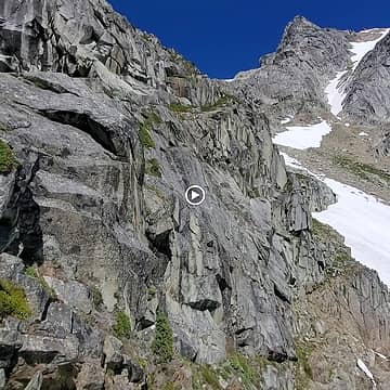 In the middle of "Z-shaped ramps" 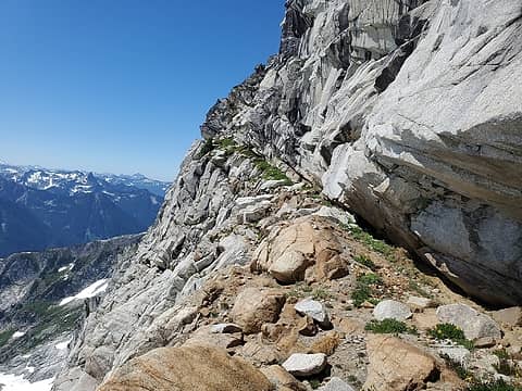 More ledgy ramps! This view is looking back (the return view) 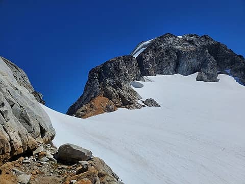 Popped out right at the col 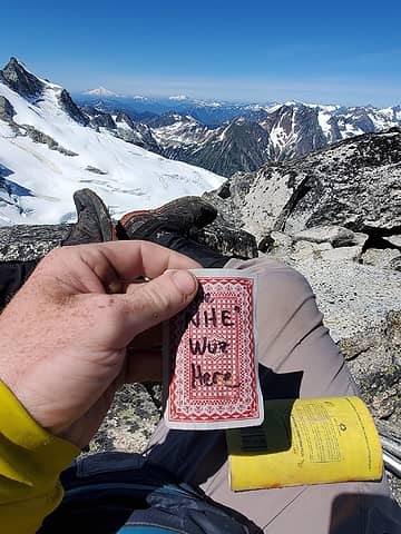 I've got a lead on the nudey card culprit!! 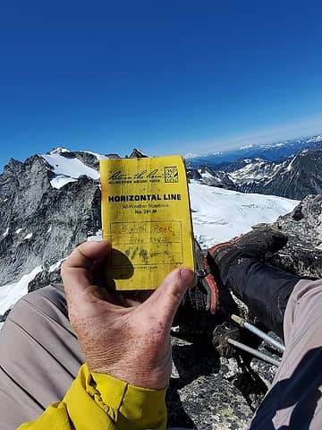 Yet another soaked summit booklet 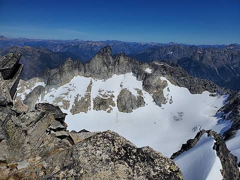 Gunsight from Sinister 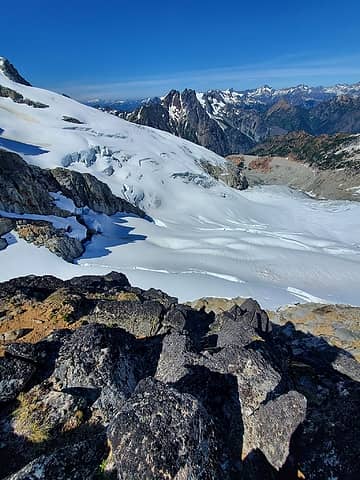 Bergie line 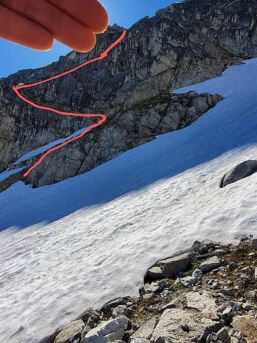 Z-shaped ramps on the return  Saturday:
Moving at 0615, I summitted Dome at 0800 via the mellow standard route and left the summit at 0845. When back to my pack at 1000, I melted snow, drank lots of water and electrolytes and headed out, knowing it was going to be another big day.
Saturday:
Moving at 0615, I summitted Dome at 0800 via the mellow standard route and left the summit at 0845. When back to my pack at 1000, I melted snow, drank lots of water and electrolytes and headed out, knowing it was going to be another big day.
 Dddooommmeee 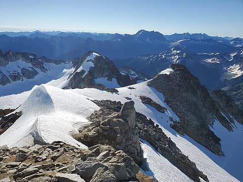 Slithering Sinister 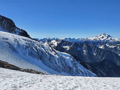 Dome Glacier terminus 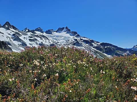 A truly alpine setting 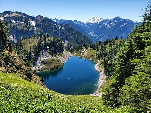 Bye, Cub 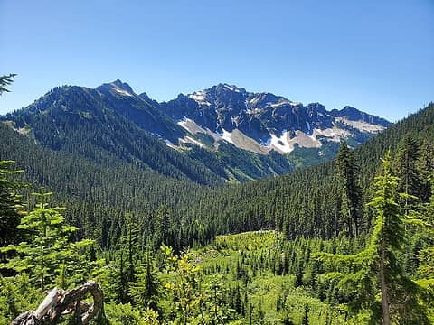 Bachelor Creek Valley 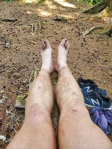 Fewer than Four. More. Miles. 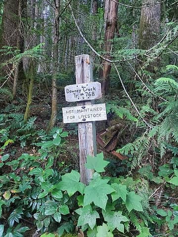 The End at 6:58 PM.
|
| Back to top |
  
|
|
Malachai Constant
Member

Joined: 13 Jan 2002
Posts: 16092 | TRs | Pics
Location: Back Again Like A Bad Penny |
How was Cub to Downey TH?
"You do not laugh when you look at the mountains, or when you look at the sea." Lafcadio Hearn
"You do not laugh when you look at the mountains, or when you look at the sea." Lafcadio Hearn
|
| Back to top |
|
|
Alden Ryno
Member
Joined: 04 Jun 2019
Posts: 150 | TRs | Pics
Location: Issaquah, WA |
Trails are in excellent condition!
|
| Back to top |
|
|
rbuzby
Attention Surplus

Joined: 24 Feb 2009
Posts: 1011 | TRs | Pics
|
|
rbuzby
Attention Surplus
|
 Mon Aug 17, 2020 7:58 am |
|
|
Any pics of the summit ridge of Dome? Beckey's famous boulder fell off decades ago; I wonder what it looks like now.
|
| Back to top |
|
|
Jonny V
Member

Joined: 20 Jul 2009
Posts: 63 | TRs | Pics
Location: Lake Stevens |
|
Jonny V
Member
|
Mon Aug 17, 2020 1:29 pm |
|
|
While the Dome area is out of this scramblers league, I have studied the area for years through books, maps and reports. Your description but especially your photography and choice of subject matter really enhanced my knowledge of what its truly like around there. Great photos.
There's time to conceive in
and time to expire
though the time twixt the two
tells the tale that transpires - "Time Waits For No One", Ambrosia
There's time to conceive in
and time to expire
though the time twixt the two
tells the tale that transpires - "Time Waits For No One", Ambrosia
|
| Back to top |
|
|
Alden Ryno
Member
Joined: 04 Jun 2019
Posts: 150 | TRs | Pics
Location: Issaquah, WA |
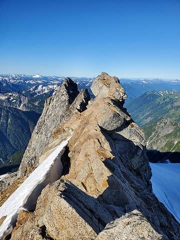 Looking toward the summit, along the ridge. 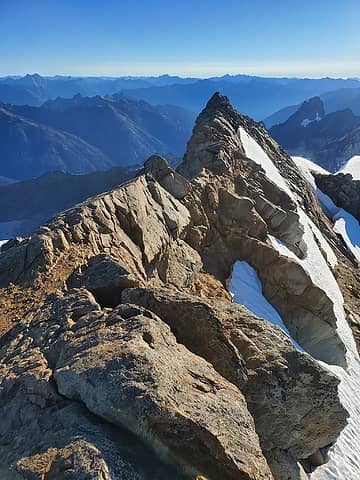 Looking back at the ridge from the summit.  Video along the ridge
|
| Back to top |
|
|
Alden Ryno
Member
Joined: 04 Jun 2019
Posts: 150 | TRs | Pics
Location: Issaquah, WA |
| Jonny V wrote: | | what its truly like around ther |
Thanks, Jonny.
I'm always amazed, perhaps flabbergasted, by how different areas area when compared with my visions of them through study.
|
| Back to top |
|
|
Doug_B
Member
Joined: 09 May 2018
Posts: 12 | TRs | Pics
|
|
Doug_B
Member
|
Mon Aug 17, 2020 1:51 pm |
|
|
Another awesome trip report. Interesting and creative approach! 7 hours from car to Cub Lake is impressive. The brush must have been tramped well this year since I don't see blood on your legs picture. I spent quality time in the brush on the way back last time!
|
| Back to top |
|
|
rbuzby
Attention Surplus
Joined: 24 Feb 2009
Posts: 1011 | TRs | Pics
|
|
rbuzby
Attention Surplus
|
Mon Aug 17, 2020 1:56 pm |
|
|
Nice pics, thanks Ryan. So clear.
|
| Back to top |
|
|
Alden Ryno
Member
Joined: 04 Jun 2019
Posts: 150 | TRs | Pics
Location: Issaquah, WA |
The brush wasn't too bad, plentiful though not impeding. I would NOT want to go through there when wet... Goodness.
It's impressive how clear the path is in the dirt yet looks like nothing when looking directly at all the brush.
Thankfully I was able to enjoy two days of barely a cloud in sight
|
| Back to top |
|
|
neek
Member

Joined: 12 Sep 2011
Posts: 2337 | TRs | Pics
Location: Seattle, WA |
|
neek
Member
|
Wed Aug 19, 2020 3:16 pm |
|
|
Very interesting report. We almost headed that way last weekend. Might have run into you on your way out.
I kind of liked the sideways avatar, seemed somehow appropriate.
|
| Back to top |
|
|
Alden Ryno
Member
Joined: 04 Jun 2019
Posts: 150 | TRs | Pics
Location: Issaquah, WA |
| neek wrote: | | seemed somehow appropriate |
I am slightly off-kilter...
|
| Back to top |
|
|
MangyMarmot
Member

Joined: 06 Apr 2012
Posts: 474 | TRs | Pics
|
Cool trip report. Nice photos. Congrats on two big peaks!
|
| Back to top |
|
|
Bob2005
Member
Joined: 20 Jan 2005
Posts: 52 | TRs | Pics
|
|
Bob2005
Member
|
Thu Aug 20, 2020 9:15 pm |
|
|
The next time you might throw your hands into the air out of disgust and toss one of your poles, you might consider instead putting on a sweater, looking in a mirror, and saying: I'm smart enough, I'm good enough, and doggonit, I deserve it!
Great TR!
|
| Back to top |
|
|
Bob2005
Member
Joined: 20 Jan 2005
Posts: 52 | TRs | Pics
|
|
Bob2005
Member
|
Thu Aug 20, 2020 9:15 pm |
|
|
The next time you might throw your hands into the air out of disgust and toss one of your poles, you might consider instead putting on a sweater, looking in a mirror, and saying: I'm smart enough, I'm good enough, and doggonit, I deserve it!  Great TR!
|
| Back to top |
|
|
|
|
You cannot post new topics in this forum
You cannot reply to topics in this forum
You cannot edit your posts in this forum
You cannot delete your posts in this forum
You cannot vote in polls in this forum
|
Disclosure: As an Amazon Associate NWHikers.net earns from qualifying purchases when you use our link(s). |


