| Previous :: Next Topic |
| Author |
Message |
ctripp
Member


Joined: 20 Feb 2019
Posts: 4 | TRs | Pics
Location: Seattle |
|
ctripp
Member
|
 Thu Aug 20, 2020 9:24 pm |
|
|
I have gleaned a lot of info from this forum over the past couple years, but don't normally post myself. I thought this outing might be of interest to some folks here, though.
I had a window for a half-ish day outing yesterdayI had to drop my wife off at work in Everett at 7:30 AM and pick her up at 5:30 PM, but that left plenty of time to head up to check out the Thornton Lakes/Trappers Peak area. I had never been to the area, but in reading a couple reports on here I was intrigued by comments from awilsondc and bootpathguy about the possibility of making a loop of it by connecting the Trappers-X ridge to the area between Lower and Middle Thornton Lakes.
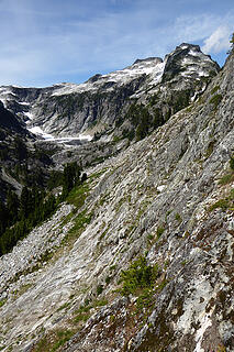
Looking at photos and the map, I assumed the crux would be making it through the obvious cliff band below the upper slopesat around 5200-5500 ft. I decided to try the loop counterclockwise, to ensure that I could enjoy the views from Trappers and X even if the loop didnt go. It helped that the expected crux was near the topno big deal if I had to turn around there. At any rate, I was pretty confident the crux cliff band would be doable by passing through a stand of trees then traversing a slab that looked to be lower-angle than the rest of the cliff. From the bottom of this, it would just be a matter of dropping down to the outlet stream through sections of talus and trees, with hopefully minimal route-finding around a couple cliff bands.
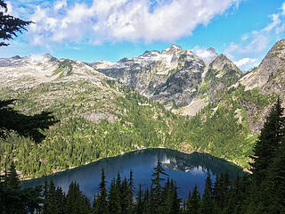 Lower Thornton Lake and Thornton Peak from the trail up Trappers Peak 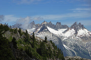 Southern Pickets from the shoulder of Trappers 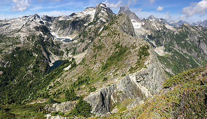 The excellent ridge walk from Trappers to X Mountain 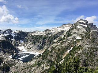 Upper Thornton Lake below Thornton Peak 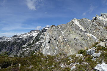 Obligatory Photo of X Mountain's namesake dikes 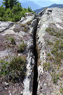 Interesting 6-10" wide fissure splitting X Mountain near its summit. Paging Brushbuffalo.  the route through the steeper upper section worked perfectlyI was pleasantly surprised as I reached the bottom of the slabs, thinking the hard part was over and turned out to be no trouble at all. the route through the steeper upper section worked perfectlyI was pleasantly surprised as I reached the bottom of the slabs, thinking the hard part was over and turned out to be no trouble at all.
 On the descent from the ridge to the lakes 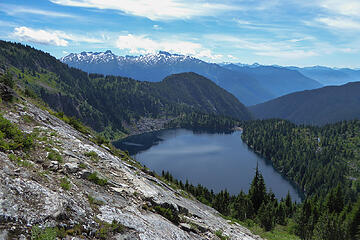 Lower Thornton Lake from the slabs on the descent 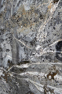 Neat banding on the smooth slabs 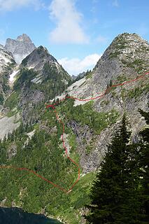 Approximate route in red 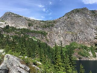 Another view of the route, from across the lake
|
| Back to top |
  
|
|
Bootpathguy
Member
Joined: 18 Jun 2015
Posts: 1787 | TRs | Pics
Location: United States |
Experience is what'cha get, when you get what'cha don't want
|
| Back to top |
|
|
ctripp
Member
Joined: 20 Feb 2019
Posts: 4 | TRs | Pics
Location: Seattle |
|
ctripp
Member
|
Thu Aug 20, 2020 11:07 pm |
|
|
|
| Back to top |
|
|
Brushbuffalo
Member

Joined: 17 Sep 2015
Posts: 1887 | TRs | Pics
Location: there earlier, here now, somewhere later... Bellingham in between |
| ctripp wrote: | Interesting 6-10" wide fissure splitting X Mountain near its summit. Paging Brushbuffalo. |
Pager just buzzed and happy to oblige!
These fractures are relatively common in the Cascades, are often dramatic and get one's pulse up when encountered if you have to cross the wider ones. I commented on a well-known one on the way to Snowking on Kindy Ridge (see below) and there is a famous gap on Cathedral Peak in the Pasayten that many have posted about and often photographed or video- recorded.
NWHiker Bluebird wrote [ reference from her Snowking climb in Fall 2019]:
"The last bit of gain to the point is really interesting with a slot canyon of significant depth."
I wrote:
"That gap is an interesting geologic feature. I think it is a large joint ( crack, like a fault but without differential movement on opposite sides). I was too preoccupied with the long ridge and its many ups and downs to give it a better examination, but it shows clearly on Google Earth. It is one of a pair of parallel twin cracks on that part of Kindy Ridge." #googleearth https://earth.app.goo.gl/vvjvkm
These gaps are not necessarily faults, which always involve differential slip of the two sides. More commonly when there is separation as in the one you picture, it is a joint ( crack), but similar to a fault, joints are caused by stress in rock to the point where the strength is exceeded such that the rock fractures. Cracking only= joint; slipping= fault.
There is a good crack on Rainbow Ridge on the east side of Mt. Baker that is a remnant of a spectacular landslide that dropped into Rainbow Gorge over 140 years ago. When I camped up on the ridge I was too chicken to sleep on the 'cliff-side' of the fracture since it is a detachment block.
Detachment blocks are what the name implies: blocks ( often huge by human standards) that are 'ready' to fall.
I have several stories about them related to civil engineering and bridges, but this response is too long already.
Passing rocks and trees like they were standing still
Passing rocks and trees like they were standing still
|
| Back to top |
|
|
Dr. T
Member
Joined: 03 Aug 2016
Posts: 80 | TRs | Pics
|
|
Dr. T
Member
|
Sat Aug 29, 2020 10:28 am |
|
|
I just did this loop on wednesday. How the hell did you make it back to pick your wife up in time?
I think i ran into the same trouble coming down from Peak X, where I found the talus field directly underneath the peak but then cut in to soon down the ramp and ran into another cliffed out section. I thought i could find my own route but realized i should just look at your pic and follow the same route. Once down the right way towards the lake before the last traverse to the middle lake outlet, i went down too far towards the lower lake. I got to an opening and realize i was too far down and would have to pull myself up through the jungle to get to a point where i could traverse, around 4800ft. Once i was able to get to the outlet i again went too far down closer to the lake and couldnt find the boot path around the West side of the lower lake and again had to climb back up, pulling myself over rocks and through trees eventually finding the boot path back to sanity. Hell of route find down from Peak X, especially with all the sections that are cliffed out and not being able to safely peer down and find the proper route. Your picture was very helpful. Aside from all that mess the view from Trapper and X are fantastic, great view into the Picket Range and mount triumph.
|
| Back to top |
|
|
|
|
You cannot post new topics in this forum
You cannot reply to topics in this forum
You cannot edit your posts in this forum
You cannot delete your posts in this forum
You cannot vote in polls in this forum
|
Disclosure: As an Amazon Associate NWHikers.net earns from qualifying purchases when you use our link(s). |


