| Previous :: Next Topic |
| Author |
Message |
Jake Robinson
Member


Joined: 02 Aug 2016
Posts: 521 | TRs | Pics
|
A few people have been pestering me to post this. I am hesitant, because if a tread were to form in the West Peak choss, it would really take away from the wilderness character of the place. These days you never know what's gonna be the next Mailbox. If that happens, my bad. But, you are welcome to tell me how awesome I am if you want.
Trip Report
I've wanted to try West Peak for a while now and Connor M and I finally made it happen this past weekend. We met up at the Dose trailhead after work on Friday night. It was overflowing with cars and I had to park a quarter mile down the road! I was also dismayed to learn that they bumped the closure another mile east since I was last here to climb Constance. Oh well, it's flat and we had bikes. We left the cars at 7PM and made camp just past Honeymoon Meadows at 11:30 PM.
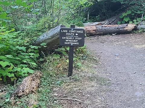 Lake Constance route got a new sign 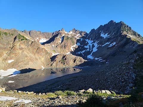 Anderson 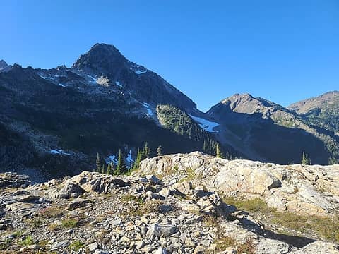 Route 2 goes up these slopes (taken on descent) 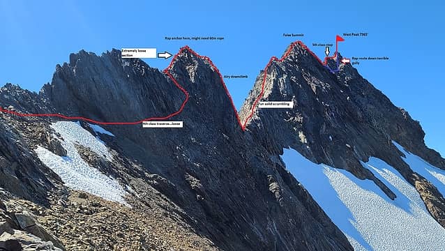 1 label Route sketch from 7100' notch. I notice one possible error with my redline, on the traverse section. It might actually go slightly lower than I marked but I can't remember at this point. 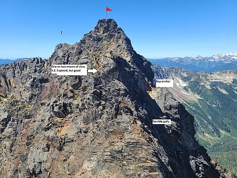 Annotated view of the true summit from the false summit with both routes shown 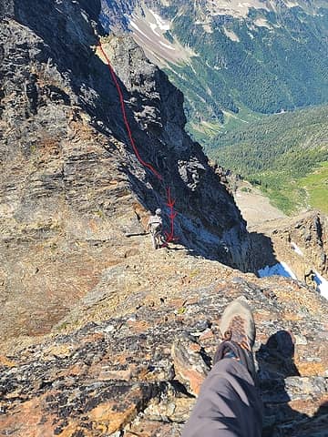 Rap gully and traverse 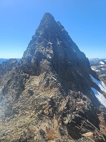 scrambling back to our gear 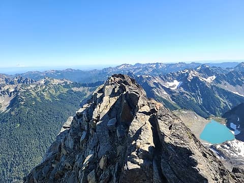 Connor enjoying Anderson summit 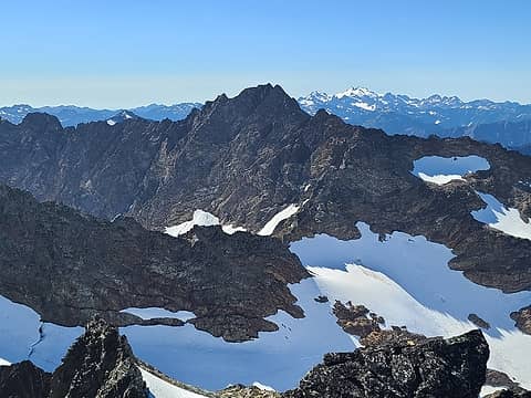 West Peak and Olympus
|
| Back to top |
  
|
|
Silas
Member
Joined: 14 Aug 2012
Posts: 77 | TRs | Pics
|
|
Silas
Member
|
 Fri Aug 21, 2020 8:47 pm |
|
|
|
| Back to top |
|
|
Brian R
Member
Joined: 10 Feb 2018
Posts: 501 | TRs | Pics
|
|
Brian R
Member
|
Fri Aug 21, 2020 9:14 pm |
|
|
One of the most elusive major summits in the Olympic Mountains. Congratulations!
How did the Eel Glacier look if one were to come up from the Silt Creek/terminus area and ascend East Peak?
|
| Back to top |
|
|
Jake Robinson
Member
Joined: 02 Aug 2016
Posts: 521 | TRs | Pics
|
Thanks for the compliments guys! I can feel the dopamine rushing through my veins...
| Brian R wrote: | | How did the Eel Glacier look if one were to come up from the Silt Creek/terminus area and ascend East Peak? |
I wish I had gotten more photos. I was too busy either trying to keep up with Connor, or too focused on the climbing to pull the camera out. But, I can tell you from memory that the Eel was looking pretty healthy. If you want to climb East Peak though, I'm sure there is a much easier way on the south side. This was originally discussed as an option, as well as Diamond, but West Peak was more than enough for us on this trip.
Another question I was pondering. So, there is the "Difficult 10" list which is Dallas Kloke's list of the 10 most difficult WA summits to attain via their easiest route. All are in the Cascades. If there was an Olympic "Difficult 10", what peaks might make that list? I know Point Harrah is class 5 by its easiest route. I can think of some pretty remote areas SE of Mt. Olympus and N of Enchanted Valley, but I'm not familiar with how difficult the peaks are.
|
| Back to top |
|
|
Silas
Member
Joined: 14 Aug 2012
Posts: 77 | TRs | Pics
|
|
Silas
Member
|
Fri Aug 21, 2020 9:54 pm |
|
|
Pics are great good. Always thought Mathias looked tough. May be the crux of the 6500 list. Not a lot of info though...
|
| Back to top |
|
|
Bluebird
suffering optional

Joined: 22 Jan 2014
Posts: 199 | TRs | Pics
Location: United States |
|
Bluebird
suffering optional
|
Fri Aug 21, 2020 10:42 pm |
|
|
count me as genuinely grateful you did not die on this mtn. 👍🏻
|
| Back to top |
|
|
cascadetraverser
Member

Joined: 16 Sep 2007
Posts: 1407 | TRs | Pics
|
Great trip Jake; looks chossy to me! Glad all went well...
|
| Back to top |
|
|
silence
Member

Joined: 25 Apr 2005
Posts: 4420 | TRs | Pics
|
|
silence
Member
|
Sat Aug 22, 2020 6:57 am |
|
|
PHOTOS
FILMS
Keep a good head and always carry a light bulb. Bob Dylan
|
| Back to top |
|
|
Malachai Constant
Member

Joined: 13 Jan 2002
Posts: 16093 | TRs | Pics
Location: Back Again Like A Bad Penny |
Most of the Olympics outside the Crescent Formation are choss piles. Glaciers are the only decent routes on them, that is why the loss of glaciers is such bad news aside from esthetics.
"You do not laugh when you look at the mountains, or when you look at the sea." Lafcadio Hearn
"You do not laugh when you look at the mountains, or when you look at the sea." Lafcadio Hearn
|
| Back to top |
|
|
IanB
Vegetable Belayer

Joined: 21 Jul 2010
Posts: 1062 | TRs | Pics
Location: gone whuljin' |
|
IanB
Vegetable Belayer
|
Sat Aug 22, 2020 1:40 pm |
|
|
Excellent trip report!  Convinced me completely that I will never attempt that summit.
"Forget gaining a little knowledge about a lot and strive to learn a lot about a little." - Harvey Manning
"Forget gaining a little knowledge about a lot and strive to learn a lot about a little." - Harvey Manning
|
| Back to top |
|
|
ozzy
The hard way

Joined: 30 Jul 2015
Posts: 476 | TRs | Pics
Location: University place, wa |
|
ozzy
The hard way
|
Sat Aug 22, 2020 3:32 pm |
|
|
I dont know whats gonna happen, but I wanna have my kicks before the whole shithouse goes up in flames-Mr Mojo Risin
|
| Back to top |
|
|
Fletcher
Member

Joined: 29 Jul 2009
Posts: 1870 | TRs | Pics
Location: kirkland |
|
Fletcher
Member
|
Sat Aug 22, 2020 3:53 pm |
|
|
|
| Back to top |
|
|
bobbi
stillaGUAMish

Joined: 13 Jul 2006
Posts: 8012 | TRs | Pics
Location: olympics! |
|
bobbi
stillaGUAMish
|
Sat Aug 22, 2020 5:57 pm |
|
|
congratulations!
impressive! thanks for sharing!
bobbi ૐ
"Today is your day! Your mountain is waiting. So
get on your way!" - Oh, the Places Youll Go! By Dr. Seuss
bobbi ૐ
"Today is your day! Your mountain is waiting. So
get on your way!" - Oh, the Places Youll Go! By Dr. Seuss
|
| Back to top |
|
|
puzzlr
Mid Fork Rocks

Joined: 13 Feb 2007
Posts: 7220 | TRs | Pics
Location: Stuck in the middle |
|
puzzlr
Mid Fork Rocks
|
Sat Aug 22, 2020 8:59 pm |
|
|
Wow! Love the summit ridge photo with annotation.
|
| Back to top |
|
|
JasonK806
Member
Joined: 15 Jul 2016
Posts: 64 | TRs | Pics
Location: Olympia, WA |
| Jake Robinson wrote: | Thanks for the compliments guys! I can feel the dopamine rushing through my veins...
| Brian R wrote: | | How did the Eel Glacier look if one were to come up from the Silt Creek/terminus area and ascend East Peak? |
I wish I had gotten more photos. I was too busy either trying to keep up with Connor, or too focused on the climbing to pull the camera out. But, I can tell you from memory that the Eel was looking pretty healthy. |
Hear's a close up of the lower Eel I took, if it helps.
Cool to see the details on the West peak, comfort in the thought I never need to attempt that one!
|
| Back to top |
|
|
|
|


 I don't think you need to worry about the Facebook crowds up there man!! Looks like some gnarly yet inviting terrain up there on the west pk!
  Thanks for the informative tr as always man. Oh and it's still hard for me to fathom the fact that you were tryin to just keep up with Connor!
  He must be pretty crazy too! Cheers and keep up the kick ass year!