| Previous :: Next Topic |
| Author |
Message |
jupsal
Member


Joined: 20 Aug 2017
Posts: 49 | TRs | Pics
|
|
jupsal
Member
|
 Wed Sep 23, 2020 8:54 pm |
|
|
| Brushbuffalo wrote: | | My Navy pilot friend says they sometimes go through passes inverted, the better to see the ground! |
The jet we saw flying over the Buck-Luahna pass flew over inverted. Quite a sight.
|
| Back to top |
  
|
|
triad
Member

Joined: 20 Jun 2020
Posts: 29 | TRs | Pics
|
|
triad
Member
|
Wed Sep 23, 2020 9:07 pm |
|
|
Thanks everyone!
| Brushbuffalo wrote: | | I once came close to setting a world record for the standing high jump when a jet came out of nowhere while I was in the headwaters of Milk Creek. The pilot in the following jet must have laughing hard before I even hit the ground. |
I've done the same. Last year going up the Napeequa valley, when a jet suddenly flew low overhead, I jumped and dove to the ground without even thinking.
| Shred wrote: | | I ran into you guys just below High Pass.
Some nice country you traveled.👌 |
Oh yeah, you were the first person we saw on the trip! Cool to run into some nwhikers in the wild haha
|
| Back to top |
|
|
Nancyann
Member
Joined: 28 Jul 2013
Posts: 2319 | TRs | Pics
Location: Sultan Basin |
|
Nancyann
Member
|
Wed Sep 23, 2020 9:52 pm |
|
|
Triad, re: your comment on my trip report about what the glacier would have looked like many years ago; there are some cool old photos you may have already seen on page 150 and 153 of Beckeys Cascade Alpine Guide for Stevens Pass to Rainy Pass. Its an aerial photograph of the area you covered from Clark down to Butterfly Butte.
|
| Back to top |
|
|
triad
Member
Joined: 20 Jun 2020
Posts: 29 | TRs | Pics
|
|
triad
Member
|
Thu Sep 24, 2020 3:54 pm |
|
|
| Nancyann wrote: | | Triad, re: your comment on my trip report about what the glacier would have looked like many years ago; there are some cool old photos you may have already seen on page 150 and 153 of Beckeys Cascade Alpine Guide for Stevens Pass to Rainy Pass. Its an aerial photograph of the area you covered from Clark down to Butterfly Butte. |
Oh cool! I'll have to track down a copy and check those out!
|
| Back to top |
|
|
GaliWalker
Have camera will use

Joined: 10 Dec 2007
Posts: 4930 | TRs | Pics
Location: Pittsburgh |
|
GaliWalker
Have camera will use
|
Thu Sep 24, 2020 4:28 pm |
|
|
 Wow, great report!
|
| Back to top |
|
|
Stuke Sowle
Member

Joined: 23 Sep 2016
Posts: 21 | TRs | Pics
Location: Issaquah, WA |
Incredible route, report and pictures! Thank you for sharing!
|
| Back to top |
|
|
Snuffy
Member

Joined: 28 Dec 2012
Posts: 315 | TRs | Pics
Location: Everett, WA |
|
Snuffy
Member
|
Sat Sep 26, 2020 5:09 pm |
|
|
What a beautiful trip! The Kennedy bridge looks about the same as when I was there in 2013, I was sure it wouldn't be there much longer then. That's one tenacious bridge!
You don't find yourself standing at the top of a mountain without having started out in the valley.
You don't find yourself standing at the top of a mountain without having started out in the valley.
|
| Back to top |
|
|
moonspots
Happy Curmudgeon

Joined: 03 Feb 2007
Posts: 2456 | TRs | Pics
Location: North Dakota |
|
moonspots
Happy Curmudgeon
|
Sun Sep 27, 2020 6:56 am |
|
|
| triad wrote: | 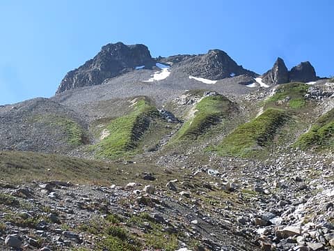 interesting contours |
A question to BrushBuffalo (or anyone who has an opinion on the appearance of the ground here): this appears to me to probably be contoured due to the melt of a long gone glacier, but it doesn't really look like the area was at the foot of a glacier though. So why the several "islands" instead of one stream do you suppose? Is this maybe the downhill side of a moraine and the glacier melted out along the sides as well as the foot? I *really* wish I were able to explore out there often enough to see more of the Cascades...
"Out, OUT you demons of Stupidity"! - St Dogbert, patron Saint of Technology
"Out, OUT you demons of Stupidity"! - St Dogbert, patron Saint of Technology
|
| Back to top |
|
|
Brushbuffalo
Member

Joined: 17 Sep 2015
Posts: 1887 | TRs | Pics
Location: there earlier, here now, somewhere later... Bellingham in between |
| moonspots wrote: | | question to BrushBuffalo (or anyone who has an opinion on the appearance of the ground here): |
You thinking in the right way, Moonspots.
There was a glacier there, long gone now, and in the latest stages it was a shelf glacier, wider than long. It would have had several meltwater streams originating from within and pouring out from its front. Each stream flowed down a relatively steep slope and eroded a slight, minor gorge, with an intervening minor
ridge between each two 'gorges'. Once the pattern formed it persists to this day....a runaway feedback process.
An important point is that these parallel ridges and gullies are in sediment rather than bedrock, the sediment being much more prone to rapid erosion.
That's my theory.
Passing rocks and trees like they were standing still
Passing rocks and trees like they were standing still
|
| Back to top |
|
|
moonspots
Happy Curmudgeon
Joined: 03 Feb 2007
Posts: 2456 | TRs | Pics
Location: North Dakota |
|
moonspots
Happy Curmudgeon
|
Sun Sep 27, 2020 9:04 am |
|
|
| Brushbuffalo wrote: | | ...and in the latest stages it was a shelf glacier, wider than long. |
Ok that explains it, I didn't even think of a "shelf" glacier. The only ones I've seen are long-ish, similar to a river.
Thanks.
"Out, OUT you demons of Stupidity"! - St Dogbert, patron Saint of Technology
"Out, OUT you demons of Stupidity"! - St Dogbert, patron Saint of Technology
|
| Back to top |
|
|
triad
Member
Joined: 20 Jun 2020
Posts: 29 | TRs | Pics
|
|
triad
Member
|
Sun Sep 27, 2020 3:55 pm |
|
|
| Snuffy wrote: | | What a beautiful trip! The Kennedy bridge looks about the same as when I was there in 2013, I was sure it wouldn't be there much longer then. That's one tenacious bridge! |
Wow, I can't believe that bridge has survived the early season snowmelt for so many years! The Canyon Creek bridge off of Highway 20 washed away after just one season of being like that.
| moonspots wrote: | | triad wrote: | interesting contours |
A question to BrushBuffalo (or anyone who has an opinion on the appearance of the ground here): this appears to me to probably be contoured due to the melt of a long gone glacier, but it doesn't really look like the area was at the foot of a glacier though. So why the several "islands" instead of one stream do you suppose? Is this maybe the downhill side of a moraine and the glacier melted out along the sides as well as the foot? I *really* wish I were able to explore out there often enough to see more of the Cascades... |
I was also wondering about these. Thanks for the explanation Brushbuffalo!
|
| Back to top |
|
|
Route Loser
Member
Joined: 24 Jul 2012
Posts: 199 | TRs | Pics
Location: Whidbey Island |
Nice trip! Way to bag Butterfly Butte the hard way. I've been meaning to get back in there when the larches turn. Good reminder and excellent photos.
|
| Back to top |
|
|
MidLifeHiker
Member

Joined: 21 Sep 2007
Posts: 193 | TRs | Pics
Location: Mukilteo |
Thanks for the great trip report and pictures. I was going to head up to Clark Mtn myself in a few days and was wondering just how brushy the White river trail is currently?
MLH
|
| Back to top |
|
|
triad
Member
Joined: 20 Jun 2020
Posts: 29 | TRs | Pics
|
|
triad
Member
|
Sat Oct 03, 2020 12:12 am |
|
|
| MidLifeHiker wrote: | | Thanks for the great trip report and pictures. I was going to head up to Clark Mtn myself in a few days and was wondering just how brushy the White river trail is currently?
MLH |
We only took the first four miles of the White River trail until you hit the turnoff for the trail towards Boulder Pass. Those first four miles of the White River trail were perfectly good though. Once we turned off onto the Boulder Creek trail it was maybe slightly brushier, but still fine trail all the way up into the Boulder Creek basin.
|
| Back to top |
|
|
|
|


