| Previous :: Next Topic |
| Author |
Message |
Zloi
Member


Joined: 30 Sep 2009
Posts: 129 | TRs | Pics
Location: Burien, haven for the helpless & homeless |
|
Zloi
Member
|
 Thu Oct 01, 2009 10:39 pm |
|
|
My third hike up Silver Creek--Aug. 29. This time I finally found the bus, which is a few minutes beyond the second intact bridge. I thought I might try to get all the way to Poodle Dog Pass this time, but I neglected to bring long pants, and the brush began to get to me beyond the Silver Ck crossing. I turned around probably a mile and a half or so past the bridge. ' ' I was curious whether the old cabin on the other side of the creek is still standing, but I don't think I hiked up far enough. I never saw it, but the slopes on the far side looked too avalanche-prone to be a likely site for a cabin. Without any maintenance, I don't think the trail beyond the still-in-use cabin's going to be very negotiable for too much longer. On passing that cabin on the way back, I heard a voice and some hammering. Someone was evidently working up in the woods, but as I didn't see a trail to the area of the sounds, I didn't bother further investigation.
Here's a link to some pix: http://picasaweb.google.com/zloi54/MinCity82910#
Below is the original trip report from Oct '09.
I drove over Jack Pass, parked near the Sky bridge, and biked from there to the rockslide across the old road up from Galena. The ride took about 45 min. Traversing the washout (which is pretty easy, actually), I proceeded up the trail/old road for maybe 40 min to the cabin (closed up this time). The first ravine after the slide has a plywood & 2x4 bridge over it which I gingerly ventured across on the way up, though preferring to downclimb & take the ladder on the return. The trail forks soon after the cabin. I took the left, uphill fork and soon ran into the deep ravine with missing bridge. This wasn't difficult to get around, but I was puzzled by why I could see no remnants over the old bridge. Hard to believe all the planks, logs, abutments-- everything apparently swept away. The trail on the other side was increasingly beset by blowdown and plant encroachment into the path, although someone had recently been hacking away at the lesser growth. Passing the engraved log, "Mineral City," I came to what must have been the site. I crossed the stream on the far side (which Beckey calls the "W. Fk" of Silver Ck and which evidently used to have a miner's trail up it, now overgrown). The trail beyond deteriorates further, reaching Silver Ck. in about another 15 min. The old road bridge over it has collapsed into the creek, except for a stout, nail-studded beam. This works fine to cross on, provided you watch your step. I hiked about 20 min farther, until a viewpoint opened onto Red Gulch and Silvertip Mt. To that point, the trail is still basically OK, though a stream has taken it over in spots. I didn't hike far enough to get to the waterfalls higher up or see the old miner's cabin across the creek valley (if it is still standing). There are some huge logs which have been left lying around, sometimes in stacks, at the Minderal City site, suggesting it may have been used as a staging area for later logging operations. Why they weren't removed as valuable timber is a bit of a mystery. ' I was curious whether the old cabin on the other side of the creek is still standing, but I don't think I hiked up far enough. I never saw it, but the slopes on the far side looked too avalanche-prone to be a likely site for a cabin. Without any maintenance, I don't think the trail beyond the still-in-use cabin's going to be very negotiable for too much longer. On passing that cabin on the way back, I heard a voice and some hammering. Someone was evidently working up in the woods, but as I didn't see a trail to the area of the sounds, I didn't bother further investigation.
Here's a link to some pix: http://picasaweb.google.com/zloi54/MinCity82910#
Below is the original trip report from Oct '09.
I drove over Jack Pass, parked near the Sky bridge, and biked from there to the rockslide across the old road up from Galena. The ride took about 45 min. Traversing the washout (which is pretty easy, actually), I proceeded up the trail/old road for maybe 40 min to the cabin (closed up this time). The first ravine after the slide has a plywood & 2x4 bridge over it which I gingerly ventured across on the way up, though preferring to downclimb & take the ladder on the return. The trail forks soon after the cabin. I took the left, uphill fork and soon ran into the deep ravine with missing bridge. This wasn't difficult to get around, but I was puzzled by why I could see no remnants over the old bridge. Hard to believe all the planks, logs, abutments-- everything apparently swept away. The trail on the other side was increasingly beset by blowdown and plant encroachment into the path, although someone had recently been hacking away at the lesser growth. Passing the engraved log, "Mineral City," I came to what must have been the site. I crossed the stream on the far side (which Beckey calls the "W. Fk" of Silver Ck and which evidently used to have a miner's trail up it, now overgrown). The trail beyond deteriorates further, reaching Silver Ck. in about another 15 min. The old road bridge over it has collapsed into the creek, except for a stout, nail-studded beam. This works fine to cross on, provided you watch your step. I hiked about 20 min farther, until a viewpoint opened onto Red Gulch and Silvertip Mt. To that point, the trail is still basically OK, though a stream has taken it over in spots. I didn't hike far enough to get to the waterfalls higher up or see the old miner's cabin across the creek valley (if it is still standing). There are some huge logs which have been left lying around, sometimes in stacks, at the Minderal City site, suggesting it may have been used as a staging area for later logging operations. Why they weren't removed as valuable timber is a bit of a mystery.
|
| Back to top |
  
|
|
blackrandy
Member

Joined: 23 Jul 2012
Posts: 7 | TRs | Pics
|
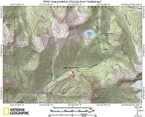
As of late July, 2012, the Silver Creek road is driveable to the first rock slide (see attached map). Of course, to get into the upper part of the North Fork of the Sky, you still have to drive over Jack Pass, since the direct road up from Index is still washed out at about mile 6. Once in the Silver Creeek Valley, beyond the first rock slide, you'll be walking up the old road bed, a very gental grade.
The Silver Creek road/trail is one of those areas that brings both a spookiness like a ghost town and a certain awe for lives of past inhabitants. The road cut into a very steep hillside above Silver Creek, the audits directly on the road, the fantastic log bridges made from local old growth, the bus, the Mineral City site....it all echoes of some distant past. Silver Creek itself is fantastically clear and lovely and the stands of old growth make this an interesting hike.
I'm surprised this trail doesn't get more traffic and the road/trail above the cabin gets overgrown enough that you'll want long pants and a dry day.
View larger size in new window 📎silver creek.gpx (52 KB)
|
| Back to top |
|
|
H. Hound
Member

Joined: 09 May 2003
Posts: 1205 | TRs | Pics
Location: Exit 32 |
|
H. Hound
Member
|
Mon Jul 30, 2012 4:30 pm |
|
|
I was up there a few weeks ago and was surprised how brushy the old road has gotten. On the inbound leg I blew right past the old bus without even noticing it. I was really happy I parked between the 2 old washouts about .33 miles from the old "trail head". Backing down the road from the rock slide to an area I could do a U turn would have sucked.
I have a hankering to see the Bonanza Mine up Molybdenum (Molly be dammed) gulch, but need to wait until the creek at Mineral City is a little more cross-able (Was running to high for me).
Some pix from July 11 for anyone interested.
|
| Back to top |
|
|
blackrandy
Member
Joined: 23 Jul 2012
Posts: 7 | TRs | Pics
|
Yeah, I would not want to back an auto down the road from the rock slide.
There's much better parking at the turnout just a few hundred meters from the slide.
I'm curious: where is the Bonanza Mine and which is Molybdenum Gulch?
|
| Back to top |
|
|
H. Hound
Member
Joined: 09 May 2003
Posts: 1205 | TRs | Pics
Location: Exit 32 |
|
H. Hound
Member
|
Tue Jul 31, 2012 4:09 pm |
|
|
Moly Gulch is past Mineral City.
 Mineral City
|
| Back to top |
|
|
Hikesume
Member

Joined: 18 May 2005
Posts: 67 | TRs | Pics
Location: Mineral City, WA |
|
Hikesume
Member
|
Sat Aug 11, 2012 7:09 am |
|
|
Hello All!
As many of you know, I usually like to pipe in whenever I see some postings on Silver Creek or Mineral City. Our Mining Explorations Group, "SUME", has been the self-proclaimed guardians of the area for a couple decades now... Me and my fellow SUME members collectively own 120 acres on the Silver Creek area, and are the owners of the old "Bus" and various other creations hidden within the trees...
Anyway, with access re-opened from the Jack's Pass side, we've seen a slight increase in foot traffic. I was just up to Mineral City a couple weeks ago, and the trail is still completely overgrown.
In regards to Mineral Center (The Bonanza Mine), the last time I made it up there was summer of 2010, and it was still standing. I've heard reports that some think the cabin collapsed, but I haven't been able to confirm this. I suspect that no one has actually been to the site for some time, and they are just assuming because they can't see it, it must be gone. If you ever have an opportunity to check this place out, it's worth the bush-beat to get there! The Mine is amazing - certainly the most complex and impressive mine up in the Silver Creek area (followed only by the elusive New York-Seattle Mine.
Anyway, I hope everyone has a safe summer of exploring! I'm heading up to Silver Creek Tomorrow-Wednesday!
See you on the Trail!
-----Skip-----
"May your Mines be Deep and Dark."
- Straight Up Mining Explorations
(Dedicated to the Research and Preservation of the Silver Creek/Mineral City areas)
"May your Mines be Deep and Dark."
- Straight Up Mining Explorations
(Dedicated to the Research and Preservation of the Silver Creek/Mineral City areas)
|
| Back to top |
|
|
Mine Explorer
Member

Joined: 19 Aug 2012
Posts: 175 | TRs | Pics
|
Was just up to Mineral City a few days ago. WOW has it gotten brushy...I ride my mountain bike ALL the way in back in...1992. Now you couldn't ride a bike for more than 10 feet, and maybe only once or twice within a mile of trail, its that brushy. That said, still very hikeable, only losing the trail once on the way back and it was only for a minute.
|
| Back to top |
|
|
Jimbo
Member

Joined: 14 Feb 2005
Posts: 1558 | TRs | Pics
Location: Arlington |
|
Jimbo
Member
|
Wed Oct 28, 2015 7:24 am |
|
|
M.E. did you all do some brushing ? What did you see ?
Guns only have two enemies; rust and politicians
Guns only have two enemies; rust and politicians
|
| Back to top |
|
|
Mine Explorer
Member
Joined: 19 Aug 2012
Posts: 175 | TRs | Pics
|
You can still go through the brush pretty easily all the way to Mineral City, but the difference from when I went up in 1992 is just mind blowing. 4 of the 5 bridges are GONE, the one remaining has a main 3 ft dia. support log dropped and may last another 5 years or so? Another has just one log remaining with a portion of planks on it, tilted - walkable but hooo boy risky...
Went up to the unnamed mine across and below the Rambler, and to the Rambler itself. Future exploration in a week or so will include more of the many, many, maaany, mines that have been found up there
|
| Back to top |
|
|
Nancyann
Member
Joined: 28 Jul 2013
Posts: 2316 | TRs | Pics
Location: Sultan Basin |
|
Nancyann
Member
|
Wed Oct 28, 2015 9:42 am |
|
|
Mine Explorer, one of my friends and I went up to the first landslide crossing last February but had to turn around due to time. We would really appreciate more info on getting around those rotten bridges. Can you drop down to Silver Creek instead?
Also, last summer I had an interesting conversation with a kid working at the Sultan Subway whose friends just got back from Mineral City via (surreptiously) Silver Lake. Apparently it was quite an expedition.
|
| Back to top |
|
|
Mine Explorer
Member
Joined: 19 Aug 2012
Posts: 175 | TRs | Pics
|
First of all.....so important...this 'hike' is definitely NOT for kids, dogs, or those inexperienced with treacherous hiking situations....
This bridge is super hairy - the picture below is heading south/returning fro the direction of Mineral City. Someone nailed boards on the downslope side for support, so with a hiking pole I felt more confident.
You tilt down to the upstream side ... thankfully you do because to the other side, if you fall, you WILL NOT SURVIVE. To the right you would fall about 10 ft and be seriously hurt:
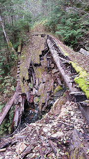 Silvercreekbridge1
|
| Back to top |
|
|
Mine Explorer
Member
Joined: 19 Aug 2012
Posts: 175 | TRs | Pics
|
The bridge above isn't as bad as the picture indicates. But not by much.
This bridge looks complete, but the log on the left - a 60 footer of old growth, at least 3ft across, has fallen.
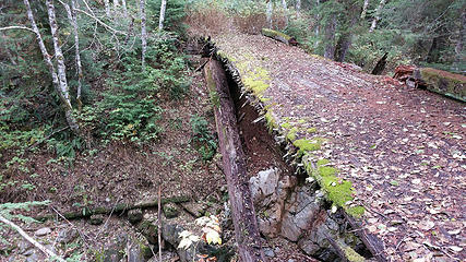 Silvercreekbridge2
|
| Back to top |
|
|
Mine Explorer
Member
Joined: 19 Aug 2012
Posts: 175 | TRs | Pics
|
The reward:
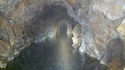 SilvercreekRamblermine
|
| Back to top |
|
|
Mine Explorer
Member
Joined: 19 Aug 2012
Posts: 175 | TRs | Pics
|
The other missing bridges: We just followed a trail down and across, no problem without a ton of water
|
| Back to top |
|
|
Mine Explorer
Member
Joined: 19 Aug 2012
Posts: 175 | TRs | Pics
|
Compare this picture with the first picture. Same bridge!
|
| Back to top |
|
|
|
|
You cannot post new topics in this forum
You cannot reply to topics in this forum
You cannot edit your posts in this forum
You cannot delete your posts in this forum
You cannot vote in polls in this forum
|
Disclosure: As an Amazon Associate NWHikers.net earns from qualifying purchases when you use our link(s). |


