| Previous :: Next Topic |
| Author |
Message |
achildinthesehills
Member


Joined: 02 Jun 2021
Posts: 16 | TRs | Pics
Location: Tukwila, WA |
Hi, I'm Peter and I'm a peakbagger. After struggling with this condition for the past year, I've decided that the best way to cope is to talk about it. While I've been putting up trip reports on the WTA site for some time, the decreasing amount of actual trail involved in my excursions means at least a partial change of venue. Plus I'm not finding the girls over there, as I had hoped. But I digress.
I would describe my peakbagging tendencies as areal. No, not aerial. And definitely not Ariel. Areal, as in picking a cluster of dots on the map and going to turn them all green in as few trips as possible, no matter how insignificant any particular summit in that group is. Perhaps surprisingly given my nearly lifelong residency in the greater Seattle area, Mount Si was still a red dot. And after tagging Little Si and Teneriffe, etc., last year, it was a red dot in a sea of green. But not the only one. The Great Buttress and the North Peak beckoned, as did what I'm calling "Middle Si", an intermediate spot elevation that had somehow escaped the Peakbagger treatment heretofore. It seemed natural, albeit somewhat unusual, to link the four up in a single trip.
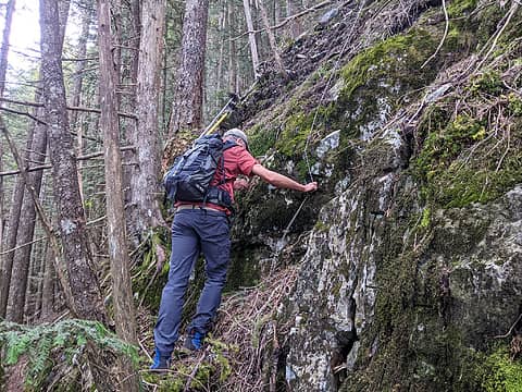
But how to go about such a thing? Common mountain sense dictates a scramble ascent and a trail descent, but "if Will Thomas can do it, I can do it" are probably not words many people can/should live by. Still, I had an idea that the route could go and I'd been researching it here and there for a few weeks. What gave me the most pause was a large amount of purple (=steep) on the map to get up to the Great Buttress. Most of my experience thus far has been trying to find ways around the purple, so this would be new. Also, the topo-satellite-LIDAR agreement is rather poor in the area due to the steep and intricate rock. At a certain point there was no further available method of research than just going up there and figuring it out.
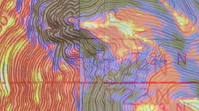 Great Buttress and environs, per several maps. The scramble route ascends the least-purple/black areas. 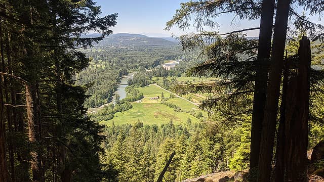 Snacktime view. 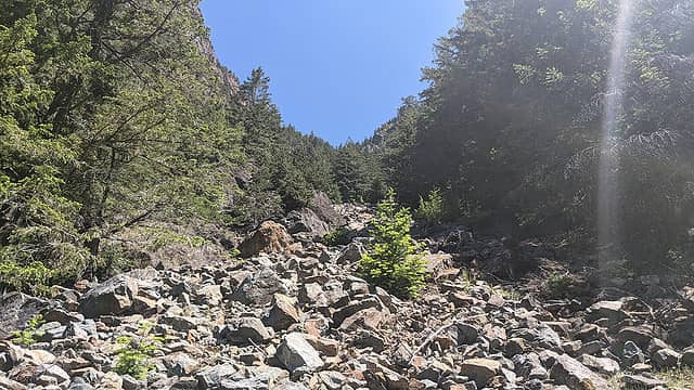 Looking up the chute. 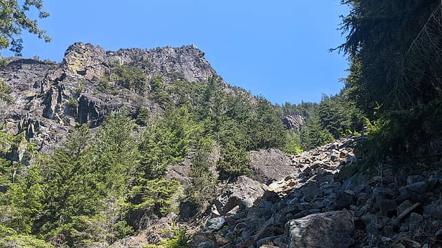 Great Buttress from the chute. 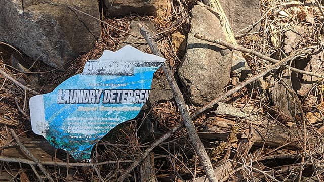 I can only imagine how and when this got there, but I know how it departed. 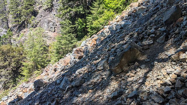 Fairly steep, but not too exposed. (Not in the purple section yet.) 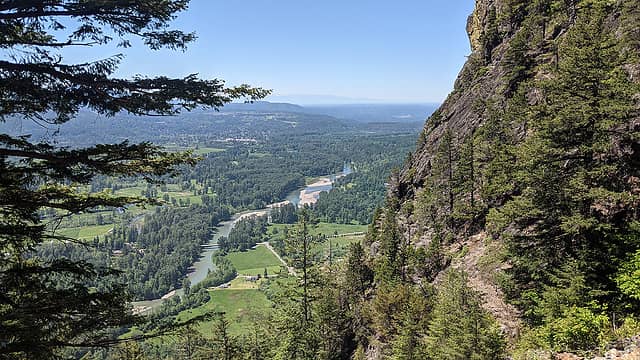 View from midway up the chute. 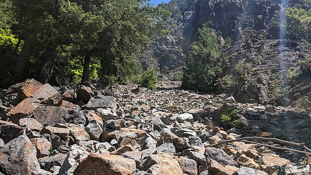 Looking up the right branch. Easy line to the left. 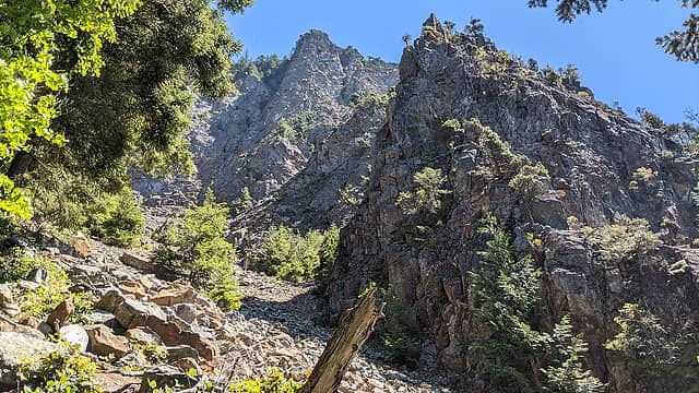 Middle Si above the chute. 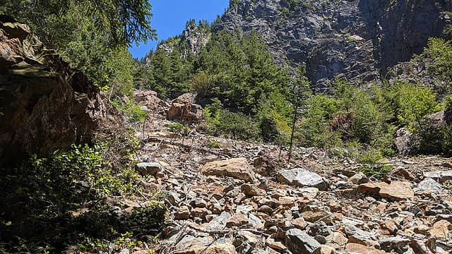 Approaching the top of the chute. 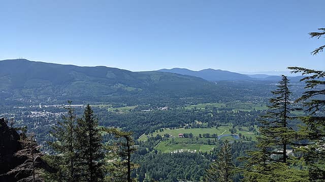 View from the top of the upper talus field. 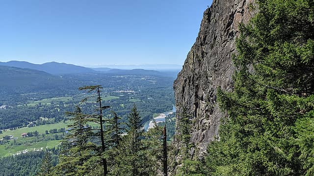 Sheer wall of the Great Buttress from the upper talus field. 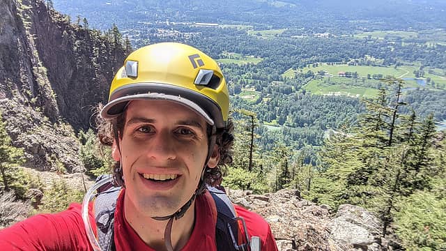 Happy to be through what I thought would be the crux of the trip. It was not. 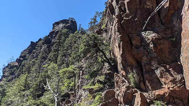 Looking up at the pinnacle. 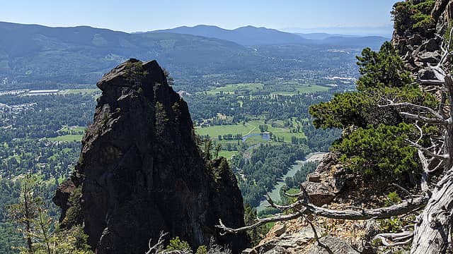 Looking down at the pinnacle. Unclimbed? 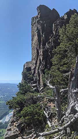 The Great Buttress summit block. Actually looks less intimidating in person, but not not-intimidating enough. 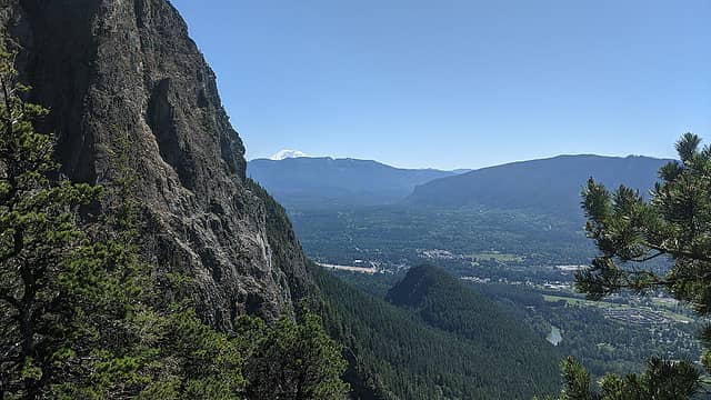 View from the base of the summit block. 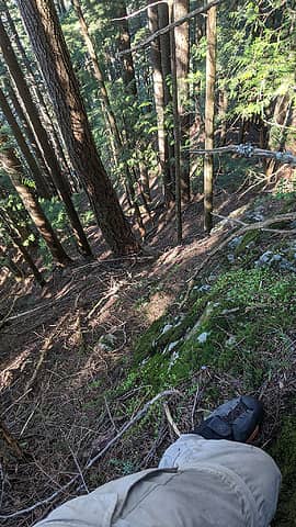 Steep. 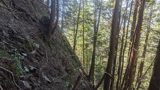 No, really. STEEP. 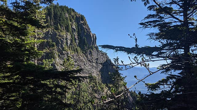 Middle Si from the top of the steep section. 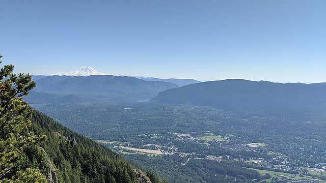 View from Middle Si. 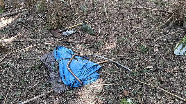 Creepy stuff on the back of the North Peak. 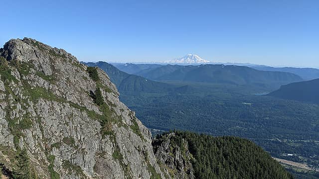 Haystack and Rainier, etc., from the North Peak. 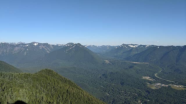 Mailbox, etc., from the Haystack. 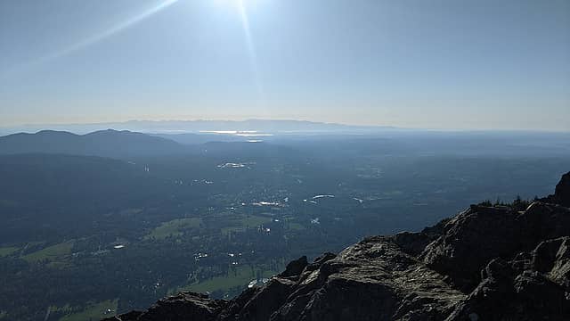 Seattle, etc., from the Haystack. 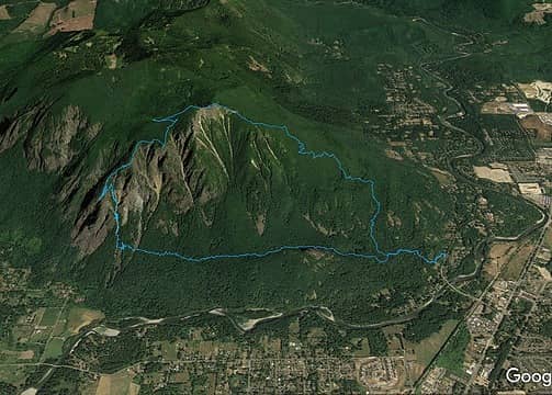 The route. - Obviously, I need to manage water better. Not difficult, but more awareness of my needs with respect to conditions is helpful.
- All the research you could possibly do to prepare only goes so far. Certain things you can only evaluate once you're there.
- I only know Will Thomas by reputation (not sure if he's on here), but he's playing an entirely different game. It took me nine hours what took him three. But without knowing the route had been completed at least once I might not have attempted it.
- Mount Si is actually a rather spectacular mountain. Sure, the crowds have pretty much ruined the character of its most accessible spots, but there are some really neat things to explore if you have the ambition.
- With that, ambition is a huge part of the mountaineering equation. Or maybe it's just an appetite for suffering. Either way, the reason this kind of thing is not done more often is because people don't want to, not because they can't. And honestly, that's okay.
"But [you] can't slow down now / As the earth has presented / A new crest to reach / Without barely a rest / From the last one"
 zimmertr, Pef, Navy salad, Mesahchie Mark, reststep zimmertr, Pef, Navy salad, Mesahchie Mark, reststep
"But [you] can't slow down now / As the earth has presented / A new crest to reach / Without barely a rest / From the last one"
zimmertr, Pef, Navy salad, Mesahchie Mark, reststep
|
| Back to top |
  
|
|
awilsondc
Member

Joined: 03 Apr 2016
Posts: 1324 | TRs | Pics
|
Creative, character building route! I'm glad you took the time to write it up, looks like a good adventure. 
|
| Back to top |
|
|
Malachai Constant
Member

Joined: 13 Jan 2002
Posts: 16092 | TRs | Pics
Location: Back Again Like A Bad Penny |
Looks like something from my younger days.
"You do not laugh when you look at the mountains, or when you look at the sea." Lafcadio Hearn
"You do not laugh when you look at the mountains, or when you look at the sea." Lafcadio Hearn
|
| Back to top |
|
|
neek
Member

Joined: 12 Sep 2011
Posts: 2336 | TRs | Pics
Location: Seattle, WA |
|
neek
Member
|
 Wed Jun 02, 2021 6:22 pm |
|
|
Excellent report. Is the glacier still pretty filled in?
|
| Back to top |
|
|
achildinthesehills
Member
Joined: 02 Jun 2021
Posts: 16 | TRs | Pics
Location: Tukwila, WA |
| neek wrote: | | Is the glacier still pretty filled in? |
Yes, definitely, but it is getting a bit late in the season. Jeez, wish I'd thought of that when I was out of water...
"But [you] can't slow down now / As the earth has presented / A new crest to reach / Without barely a rest / From the last one"
"But [you] can't slow down now / As the earth has presented / A new crest to reach / Without barely a rest / From the last one"
|
| Back to top |
|
|
Malachai Constant
Member
Joined: 13 Jan 2002
Posts: 16092 | TRs | Pics
Location: Back Again Like A Bad Penny |
By the way did you see any evidence of the paraglide who disappeared there a few years ago.?
"You do not laugh when you look at the mountains, or when you look at the sea." Lafcadio Hearn
"You do not laugh when you look at the mountains, or when you look at the sea." Lafcadio Hearn
|
| Back to top |
|
|
achildinthesehills
Member
Joined: 02 Jun 2021
Posts: 16 | TRs | Pics
Location: Tukwila, WA |
| Malachai Constant wrote: | | Did you see any evidence of the paraglider who disappeared there a few years ago? |
Unless he had a shovel and some tarps with him, nope. Actually, the thought of coming across that scene had me more nervous at times than did any steep slope.
"But [you] can't slow down now / As the earth has presented / A new crest to reach / Without barely a rest / From the last one"
"But [you] can't slow down now / As the earth has presented / A new crest to reach / Without barely a rest / From the last one"
|
| Back to top |
|
|
puzzlr
Mid Fork Rocks

Joined: 13 Feb 2007
Posts: 7220 | TRs | Pics
Location: Stuck in the middle |
|
puzzlr
Mid Fork Rocks
|
Wed Jun 02, 2021 9:08 pm |
|
|
When it rains it pours! Three of us happened to do that same traverse on April 21 this year.
The crux for us was at about the 3100' level on the ridge above the Great Buttress. We used a hand line for safety on the slabby mossy rocks because the consequences of a fall were potentially serious. After looking back at the lidar-based contour map and with some time to explore and we might have been able to find an easier way through that section. But I agree -- there is a lot of steep terrain in there and then you get to the 3400' plateau and it's like a different world -- gentle slopes in an open forest.
 Crux | Quote: | | Mount Si is actually a rather spectacular mountain. |
So true. Mount Si is much more than just the Si trail.
|
| Back to top |
|
|
achildinthesehills
Member
Joined: 02 Jun 2021
Posts: 16 | TRs | Pics
Location: Tukwila, WA |
Hi puzzlr! Another stalwart I know by reputation only. Somehow I missed that recent album in my preparations, but it all looks familiar now, of course.
I agree about the crux thereI think it was just luck to find a way that was more dirt/roots than rock, so I never felt particularly unprotected. But it was relentless.
Your moving time was about what mine would have been without the lower traverse. Would have been faster still without the heat/dehydration.
I actually picked up an inReach just a couple weeks ago; probably should have done that sooner. Definitely makes my mother less nervous!
"But [you] can't slow down now / As the earth has presented / A new crest to reach / Without barely a rest / From the last one"
"But [you] can't slow down now / As the earth has presented / A new crest to reach / Without barely a rest / From the last one"
|
| Back to top |
|
|
puzzlr
Mid Fork Rocks
Joined: 13 Feb 2007
Posts: 7220 | TRs | Pics
Location: Stuck in the middle |
|
puzzlr
Mid Fork Rocks
|
Wed Jun 02, 2021 9:51 pm |
|
|
It's hard to get the results you're looking for when googling "Mount Si"!
|
| Back to top |
|
|
mosey
Member

Joined: 18 Dec 2018
Posts: 163 | TRs | Pics
|
|
mosey
Member
|
Wed Jun 02, 2021 10:08 pm |
|
|
Ive enjoyed your trip reports. Nice effort.
zimmertr
zimmertr |
| Back to top |
|
|
KascadeFlat
Member
Joined: 06 Jul 2020
Posts: 314 | TRs | Pics
Location: Eating peanut M&Ms under my blue tarp |
For a good time call: 1-800-SLD-ALDR.
|
| Back to top |
|
|
Navy salad
Member

Joined: 09 Sep 2008
Posts: 1865 | TRs | Pics
Location: Woodinville |
EXCELLENT and entertaining trip report!
|
| Back to top |
|
|
willtheskifreak
Member
Joined: 25 Oct 2014
Posts: 1 | TRs | Pics
Location: North Bend |
Congrats on completing such a fun loop. It sure is fun to see Mt. Si from a different perspective. Keep inspiring with the great adventures.
|
| Back to top |
|
|
achildinthesehills
Member
Joined: 02 Jun 2021
Posts: 16 | TRs | Pics
Location: Tukwila, WA |
| willtheskifreak wrote: | | Congrats on completing such a fun loop. It sure is fun to see Mt. Si from a different perspective. Keep inspiring with the great adventures. |
Thanks, Will! Means a lot coming from you.
"But [you] can't slow down now / As the earth has presented / A new crest to reach / Without barely a rest / From the last one"
"But [you] can't slow down now / As the earth has presented / A new crest to reach / Without barely a rest / From the last one"
|
| Back to top |
|
|
|
|
You cannot post new topics in this forum
You cannot reply to topics in this forum
You cannot edit your posts in this forum
You cannot delete your posts in this forum
You cannot vote in polls in this forum
|
Disclosure: As an Amazon Associate NWHikers.net earns from qualifying purchases when you use our link(s). |


