| Previous :: Next Topic |
| Author |
Message |
DIYSteve
seeking hygge


Joined: 06 Mar 2007
Posts: 12655 | TRs | Pics
Location: here now |
|
DIYSteve
seeking hygge
|
 Sun Feb 06, 2011 10:49 am |
|
|
Notes from August 2010. Conditions: overcast, showers, rain
The Berdeen Lake Route (BLR) ascends the ridge between Bacon Creek and the N Fork of Bacon Creek, then high across a series of cirques to the 5595' saddle E of Lake Berdeen. This post includes notes of the route from the end of FS Road 1060 to the N end of Lake Berdeen. One may continue a high country traverse by exiting over Bacon Peak/Mt. Watson or over the Hagan Mtn. massif and down the Blum Access. For info re these exits, see the very popular TR Intro to the North Cascades with Mike and Tom 9-8/14-07.
The BLR starts in lowland terrain at the end of FS Road 1060. Beyond there, the old roadbed has been badly eroded and overtaken by the forest.
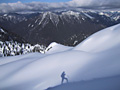
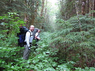 day1.1 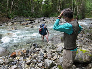 day1.2 crossing E fork bacon creek 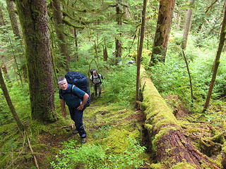 day1.3 low on berdeen HR 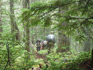 day1.5 mark & shawn working up BHR 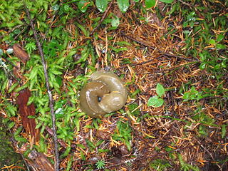 day1.4 slug ying yang 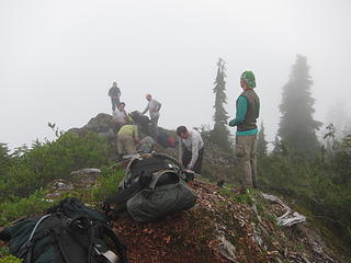 day1.8 break at pt4940 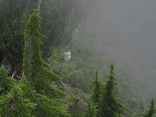 day2.1 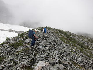 day2.7 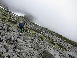 day2.8 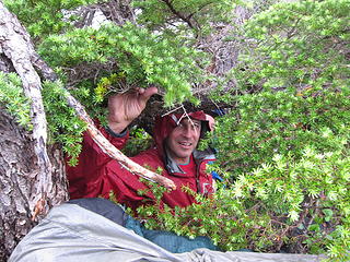 day2.9 andy taking cover at 5995 saddle 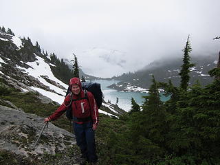 day2.10 kevin above berdeen lake 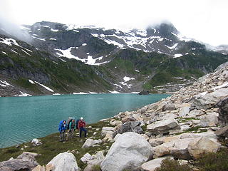 day2.11 berdeen lake 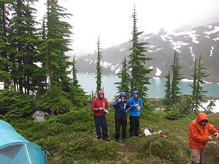 day2.12 soggy camp2 | Quote: | | It is hard to describe the feeling of standing on the shores of Berdeen, other than to say it evoked emotions deep from within. |
|
| Back to top |
  
|
|
Schroder
Member

Joined: 26 Oct 2007
Posts: 6722 | TRs | Pics
Location: on the beach |
|
Schroder
Member
|
Sun Feb 06, 2011 10:59 am |
|
|
Thanks very much for this report, Steve. It'll come in handy if I ever make it there.
|
| Back to top |
|
|
iron
Member

Joined: 10 Aug 2008
Posts: 6392 | TRs | Pics
Location: southeast kootenays |
|
iron
Member
|
Sun Feb 06, 2011 11:02 am |
|
|
|
| Back to top |
|
|
Tom
Admin
Joined: 15 Dec 2001
Posts: 17853 | TRs | Pics
|
|
Tom
Admin
|
Sun Feb 06, 2011 11:39 am |
|
|
Nice writeup. Actually, that quote of mine was from a different TR (the first trip with Ed). On the trip with SA someone had a campfire going when we arrived at Berdeen. That evoked some emotions too. 
|
| Back to top |
|
|
DIYSteve
seeking hygge
Joined: 06 Mar 2007
Posts: 12655 | TRs | Pics
Location: here now |
|
DIYSteve
seeking hygge
|
Sun Feb 06, 2011 11:42 am |
|
|
|
| Back to top |
|
|
RichP
Member

Joined: 13 Jul 2006
Posts: 5634 | TRs | Pics
Location: here |
|
RichP
Member
|
Sun Feb 06, 2011 12:00 pm |
|
|
This is a trip that's definitely on my wish list for this year.
|
| Back to top |
|
|
Jason Hummel
Member

Joined: 31 Aug 2006
Posts: 1209 | TRs | Pics
Location: Tacoma Washington |
Awesome.
When I was there, I sat on the shores of the upper lake and watched a bear graze and meander. It was a special moment in a very special place. I especially love the waterfalls seen on the way there from Watson.
Thanks for the report on your adventure!
|
| Back to top |
|
|
Dayhike Mike
Bad MFKer
Joined: 02 Mar 2003
Posts: 10958 | TRs | Pics
Location: Going to Tukwila |
"There is only one basic human right, the right to do as you damn well please. And with it comes the only basic human duty, the duty to take the consequences." -P.J. O'Rourke
"Ignorance is natural. Stupidity takes commitment." -Solomon Short
|
| Back to top |
|
|
Matt Lemke
High on the Outdoors

Joined: 15 Jul 2010
Posts: 2052 | TRs | Pics
Location: Grand Junction |
|
Matt Lemke
High on the Outdoors
|
Sun Feb 06, 2011 8:39 pm |
|
|
That would be a great trip I'd hope to do this summer!
Thank you for posting
|
| Back to top |
|
|
DIYSteve
seeking hygge
Joined: 06 Mar 2007
Posts: 12655 | TRs | Pics
Location: here now |
|
DIYSteve
seeking hygge
|
Mon Feb 07, 2011 8:43 am |
|
|
| Jason Hummel wrote: | | Thanks for the report on your adventure! |
| Dayhike Mike wrote: | | Beautiful TR! |
Thanks for the thanks, but this was not intended as a trip report. I wanted to post route notes on a portion of a longer trip.  Things got really adventurous the day after we arrived at camp at Berdeen, but for several reasons I've elected to not post about the remainder of the trip.
Mike, there is no water on the ridge between Bacon Creek and the pothole micro-tarn SE of Pt. 4940. Thanks for mentioning that. For anyone attempting this route, bring lots of water! Note that most of the route below Pt. 4940 is forested and shady, but one could get parched scrambling up the numerous scrub cedar-choked cliff bands. We had cool damp weather and the routefinding went smoothly so we had water to spare when we topped out. Things got really adventurous the day after we arrived at camp at Berdeen, but for several reasons I've elected to not post about the remainder of the trip.
Mike, there is no water on the ridge between Bacon Creek and the pothole micro-tarn SE of Pt. 4940. Thanks for mentioning that. For anyone attempting this route, bring lots of water! Note that most of the route below Pt. 4940 is forested and shady, but one could get parched scrambling up the numerous scrub cedar-choked cliff bands. We had cool damp weather and the routefinding went smoothly so we had water to spare when we topped out.
|
| Back to top |
|
|
fffej50
Member
Joined: 13 Oct 2007
Posts: 65 | TRs | Pics
Location: poulsbo |
|
fffej50
Member
|
Mon Feb 07, 2011 3:01 pm |
|
|
it really is a spectacular pristine place. when we did it it took us the better part of 2 and a half days from Bacon to Berdeen and Becky indicated that it could be done in 9 hours........we went out via Blum.......
|
| Back to top |
|
|
Backpacker Joe
Blind Hiker

Joined: 16 Dec 2001
Posts: 23956 | TRs | Pics
Location: Cle Elum |
Thanks Steve. Great story. Any chance someone had a GPS along the way?
"If destruction be our lot we must ourselves be its author and finisher. As a nation of freemen we must live through all time or die by suicide."
Abraham Lincoln
"If destruction be our lot we must ourselves be its author and finisher. As a nation of freemen we must live through all time or die by suicide."
Abraham Lincoln
|
| Back to top |
|
|
DICE
Member
Joined: 12 Jun 2010
Posts: 12 | TRs | Pics
|
|
DICE
Member
|
Mon Feb 07, 2011 8:25 pm |
|
|
Thanks for sharing!! Our group was there mid August the under blue skies. We came into Berdeen from Green Lake.
I like the pics from the North/East side of the lake, we were on the opposite side. Wish we would have camped there, we ended up camping high on Hagan instead. The next time I am in this country, I will take the extra day(or 2) to camp and explore the area.
|
| Back to top |
|
|
DIYSteve
seeking hygge
Joined: 06 Mar 2007
Posts: 12655 | TRs | Pics
Location: here now |
|
DIYSteve
seeking hygge
|
Tue Feb 08, 2011 8:33 am |
|
|
| Backpacker Joe wrote: | | Any chance someone had a GPS along the way? |
Andy and I had GPS units, but they were of little use on the ridge where routefinding through and around cliffs was the issue, not navigation. The units did come in handy in the pea soup conditions en route to the saddle.
|
| Back to top |
|
|
Backpacker Joe
Blind Hiker
Joined: 16 Dec 2001
Posts: 23956 | TRs | Pics
Location: Cle Elum |
Mostly I was hoping to see a mapped version of your route. Its fun to look at those.
"If destruction be our lot we must ourselves be its author and finisher. As a nation of freemen we must live through all time or die by suicide."
Abraham Lincoln
"If destruction be our lot we must ourselves be its author and finisher. As a nation of freemen we must live through all time or die by suicide."
Abraham Lincoln
|
| Back to top |
|
|
|
|


