Curious if anyone knows the condition of the Coal Creek Road (near Devils Peak, MLH) and whether it is walkable or very overgrown. I recall snowshoeing by it a couple years ago on the way to Kalcema Lake and don't remember a lot of brush but maybe someone else has been there more recently.
Deer Creek Road (FR 4052) to Lake Kelcema is maintained and drivable in the summer. The road branch up the Coal Creek side shown as FR 4054 on Forest Service maps was decommissioned back around 1970. That's the route that gets you back to Devils Peak and Lake.
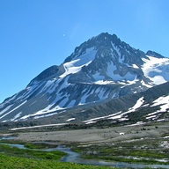
It's a decent snowshoe route, although pretty brushy, but not too hard to follow. If the gate on Deer Creek road is closed, it is 0.8 mile to the trail start, you will see a branch to the right, just where the road curves left. When we did it we saw a marten running off in the snow which was pretty cool. About a mile in there will be a steep slope on your left that could have some avy risk, at that point on a clear day you can see Big 4 to the south. https://www.nwhikers.net/forums/viewtopic.php?t=7995533
Go placidly amid the noise and waste, and remember what comfort there may be in owning a piece thereof.
0
Go placidly amid the noise and waste, and remember what comfort there may be in owning a piece thereof.
It's a decent snowshoe route, although pretty brushy, but not too hard to follow. If the gate on Deer Creek road is closed, it is 0.8 mile to the trail start, you will see a branch to the right, just where the road curves left. When we did it we saw a marten running off in the snow which was pretty cool. About a mile in there will be a steep slope on your left that could have some avy risk, at that point on a clear day you can see Big 4 to the south. https://www.nwhikers.net/forums/viewtopic.php?t=7995533
Thanks for sending along the report. Looks like this is an ok route with sufficient snow, though it seems like there may not be a huge amount to cover the brush along the road at the moment. If I head that way this weekend I'll be sure to report back.
Not sure snow is going to help much on this one, the brush is tall. It is not too thick though, until you get around the bend and closer to Devil's Peak. There is a good chance that your trip will end when you tire of the brush, and that may very well happen before you get a view.
Between every two pines is a doorway to the new world. - John Muir
0
Between every two pines is a doorway to the new world. - John Muir
You cannot post new topics in this forum You cannot reply to topics in this forum You cannot edit your posts in this forum You cannot delete your posts in this forum You cannot vote in polls in this forum
Disclosure: As an Amazon Associate NWHikers.net earns from qualifying purchases when you use our link(s).