| Previous :: Next Topic |
| Author |
Message |
Matt
Tea, Earl Grey, Hot


Joined: 30 Jan 2007
Posts: 4307 | TRs | Pics
Location: Shoreline |
|
Matt
Tea, Earl Grey, Hot
|
 Fri Jan 29, 2021 12:00 am |
|
|
Date: 1/23/2021
Destination: Galleon Mtn 5283 (USGS Snoqualmie Lake)
Party: Matt, Carla, Elle
Short Version: We hiked up the Green Ridge trail to Green Ridge and Hi Low Lakes, then went up steep forest to the col just left of the sharp outcrop south of the summit, and followed the crest to the top. Firm crusty snow made for straightforward cramponing, with no rope needed. We followed excellent directions from Monty's trip report.
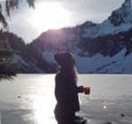
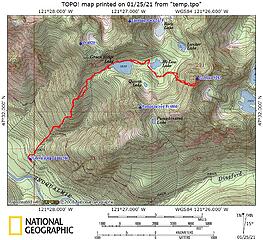 Galleon GPS Track 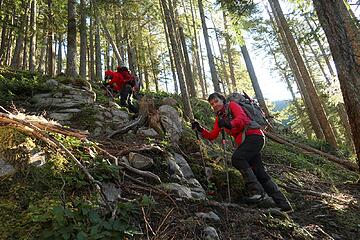 steep trail 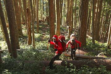 a very green forested ridge 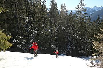 Hiking up toward Green Ridge Lake 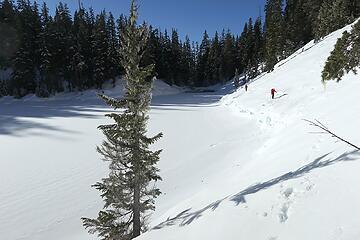 Traversing along the edge of Green Ridge Lake 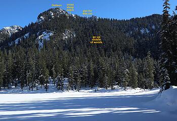 Route from Green Ridge Lake to Galleon 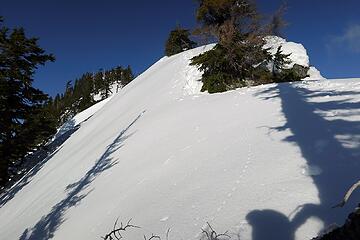 Steep traverse along the crest toward the summit 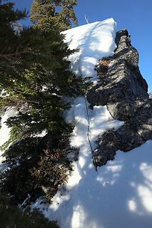 Notch with Gabriel's old rope buried in snow 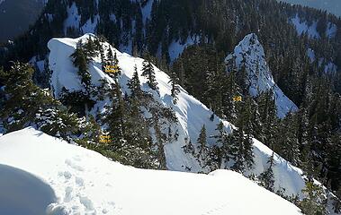 Looking back from the summit to the notch and col 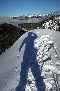 I made it to the top 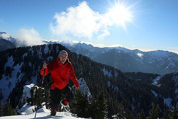 Me walking around near the summit 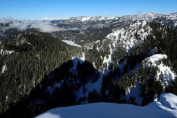 Looking northeast to Snoqualmie Lake and Glacier Peak 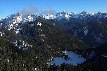 Looking east to Horseshoe Lake, Big Snow, and the Snoqualmie Crest 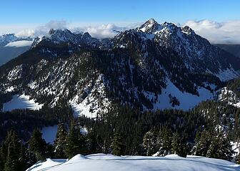 Looking northwest to Garfield and Treen, plus Green Ridge and Hi-Low Lakes 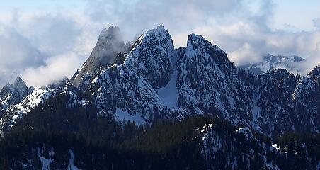 Closer view of Garfield and East Garfield 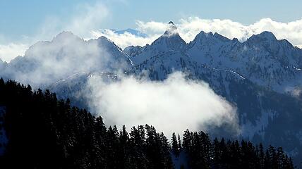 Looking south to Chair & Kaleetan (and the top of Rainier) 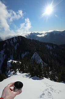 Tea, tracks, and sunshine 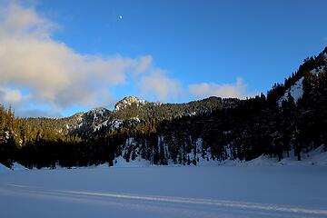 Last light and rising moon on the way out.
As beacons mountains burned at evening. J.R.R. Tolkien
As beacons mountains burned at evening. J.R.R. Tolkien
|
| Back to top |
  
|
|
RichP
Member

Joined: 13 Jul 2006
Posts: 5634 | TRs | Pics
Location: here |
|
RichP
Member
|
Fri Jan 29, 2021 9:40 am |
|
|
That took determination to make it up there in winter. I don't suppose you found Monty's register under the snow?
|
| Back to top |
|
|
Stefan
Member

Joined: 17 Dec 2001
Posts: 5091 | TRs | Pics
|
|
Stefan
Member
|
Fri Jan 29, 2021 9:48 am |
|
|
beautiful shots...as usual!
|
| Back to top |
|
|
Randy
Cube Rat

Joined: 18 Dec 2001
Posts: 2910 | TRs | Pics
Location: Near the Siamangs |
|
Randy
Cube Rat
|
Fri Jan 29, 2021 11:42 am |
|
|
Love that summit. I think I did that trip with Stefan. I think...
|
| Back to top |
|
|
dicey
custom title

Joined: 11 May 2004
Posts: 2870 | TRs | Pics
Location: giving cornices a wider berth |
|
dicey
custom title
|
Fri Jan 29, 2021 5:44 pm |
|
|
You did! And me, and Cartman and the Beave and several others. We had terrible weather and no views!
|
| Back to top |
|
|
Randy
Cube Rat
Joined: 18 Dec 2001
Posts: 2910 | TRs | Pics
Location: Near the Siamangs |
|
Randy
Cube Rat
|
Fri Jan 29, 2021 6:46 pm |
|
|
|
| Back to top |
|
|
KascadeFlat
Member
Joined: 06 Jul 2020
Posts: 316 | TRs | Pics
Location: Eating peanut M&Ms under my blue tarp |
That trail from the road to Green Ridge lake is no joke. I attempted Galleon in 2019 and I think I need a couple more years of rest before tackling that one again.  Good for you guys for getting out there in January! I am inspired. Good for you guys for getting out there in January! I am inspired.
For a good time call: 1-800-SLD-ALDR.
For a good time call: 1-800-SLD-ALDR.
|
| Back to top |
|
|
puzzlr
Mid Fork Rocks

Joined: 13 Feb 2007
Posts: 7220 | TRs | Pics
Location: Stuck in the middle |
|
puzzlr
Mid Fork Rocks
|
Sun Jan 31, 2021 1:16 am |
|
|
Matt, I think you're right that the summit ridge is easier with a solid snow pack. It's fun how Gabriel's stuck rope lives on in TRs.
| Matt wrote: | Closer view of Garfield and East Garfield |
What's up with the main Garfield peak being snow free and East Garfield ridge being plastered and corniced?
|
| Back to top |
|
|
Brushbuffalo
Member

Joined: 17 Sep 2015
Posts: 1887 | TRs | Pics
Location: there earlier, here now, somewhere later... Bellingham in between |
| Matt wrote: | a very green forested ridge Me walking around near the summit |
Excellent trip in stellar midwinter conditions by Team Red.
Passing rocks and trees like they were standing still
Passing rocks and trees like they were standing still
|
| Back to top |
|
|
Brushbuffalo
Member
Joined: 17 Sep 2015
Posts: 1887 | TRs | Pics
Location: there earlier, here now, somewhere later... Bellingham in between |
| puzzlr wrote: | | What's up with the main Garfield peak being snow free and East Garfield ridge being plastered and corniced? |
Maybe just that the snow can't stick to the steep slabs but can adhere when held by veg. and broken rock. I haven't climbed either peak, so this is just a wild hypothesis based only on the picture.
Passing rocks and trees like they were standing still
Passing rocks and trees like they were standing still
|
| Back to top |
|
|
Mike Collins
Member

Joined: 18 Dec 2001
Posts: 3096 | TRs | Pics
|
| puzzlr wrote: | What's up with the main Garfield peak being snow free and East Garfield ridge being plastered and corniced?
Closer view of Garfield and East Garfield |
A number of years ago I climbed the main summit of Garfield on Feb 19. The approach was from the north via the North Pass. You will definitely be kicking steps in the high-angled snow to reach the summit from the north in the winter.
|
| Back to top |
|
|
iron
Member

Joined: 10 Aug 2008
Posts: 6392 | TRs | Pics
Location: southeast kootenays |
|
iron
Member
|
Sun Jan 31, 2021 11:50 pm |
|
|
this TR is like the who's who list of yesteryear. even a dicey post. just need quark, DHM, geohiker, and a few others and it'll be like 2008 all over again.
|
| Back to top |
|
|
Type E
Member

Joined: 19 Aug 2006
Posts: 1381 | TRs | Pics
|
|
Type E
Member
|
Mon Feb 01, 2021 12:07 am |
|
|
Thanks for the reminder, didnt quite make this one. I think tomorrows the day I retire and revisit climbing
|
| Back to top |
|
|
Mike Collins
Member
Joined: 18 Dec 2001
Posts: 3096 | TRs | Pics
|
| iron wrote: | | this TR is like the who's who list of yesteryear. |
Yesteryear...Ouch... I was so upset the tennis balls flew off my walker.
|
| Back to top |
|
|
Quark
Niece of Alvy Moore

Joined: 15 May 2003
Posts: 14152 | TRs | Pics
|
|
Quark
Niece of Alvy Moore
|
Mon Feb 15, 2021 9:44 am |
|
|
| Mike Collins wrote: | | iron wrote: | | this TR is like the who's who list of yesteryear. |
Yesteryear...Ouch... I was so upset the tennis balls flew off my walker. |
Mine too. But first, I had to pick up my teeth after they fell out of my mouth when I shouted outrage and other endearing expletives after reading this. darn whippersnappers.
"...Other than that, the post was more or less accurate."
Bernardo, NW Hikers' Bureau Chief of Reporting
"...Other than that, the post was more or less accurate."
Bernardo, NW Hikers' Bureau Chief of Reporting
|
| Back to top |
|
|
|
|


