| Previous :: Next Topic |
| Author |
Message |
thuja
Member


Joined: 13 Sep 2018
Posts: 67 | TRs | Pics
|
|
thuja
Member
|
 Fri Apr 02, 2021 8:02 pm |
|
|
Anyone know the scoop on the Bessemer road?
I was up there today and there is a DNR sign in front of the blue gate saying the road is closed because of construction. We made it to the top of the ridge and I can assure you there were no signs of construction work ongoing or planned (survey stakes, materials staging, etc). The big washout is still a huge gash in the hillside. Snow covers the road above 2200'.
|
| Back to top |
  
|
|
Navy salad
Member

Joined: 09 Sep 2008
Posts: 1865 | TRs | Pics
Location: Woodinville |
Sorry, I don't know the status regarding road construction, but I am wondering how the trail is. I had thought it was badly overgrown and for that reason haven't been up there.
|
| Back to top |
|
|
hatchetation
Member
Joined: 11 Jun 2017
Posts: 37 | TRs | Pics
Location: Seattle |
Vaguely remember seeing some planning docs for a project to construct an actual trailhead further up Bessemer Rd, at that old salvage timber area. Included was a new trail just East of the road from the TH to the CCC, IIRC.
I think they were looking to start work this year. WA DNR has a healthy handful of trail work queued up for the area, including relocations, bridge construction west on the CCC, and retiring the Sitka Spruce trail. Not sure how I feel about that last one.
|
| Back to top |
|
|
puzzlr
Mid Fork Rocks

Joined: 13 Feb 2007
Posts: 7220 | TRs | Pics
Location: Stuck in the middle |
|
puzzlr
Mid Fork Rocks
|
Thu Apr 15, 2021 9:20 pm |
|
|
| hatchetation wrote: | | planning docs for a project to construct an actual trailhead further up Bessemer Rd |
That would be the "East Snoqualmie Corridor Recreaction Plan - Phase II" on this page. There's a lot more in there too, including a new trail to Absolute Last Promontory and new trail bridges along the CCC trail.
|
| Back to top |
|
|
mosey
Member

Joined: 18 Dec 2018
Posts: 163 | TRs | Pics
|
|
mosey
Member
|
Sun Apr 25, 2021 10:33 pm |
|
|
| puzzlr wrote: | | hatchetation wrote: | | planning docs for a project to construct an actual trailhead further up Bessemer Rd |
That would be the "East Snoqualmie Corridor Recreaction Plan - Phase II" on this page. There's a lot more in there too, including a new trail to Absolute Last Promontory and new trail bridges along the CCC trail. |
Yikes, I hope they don't decommission the sitka spruce trail. Those 5 miles on the CCC aren't much fun without a bike. As I understand, a primary concern is treading on old growth roots? erosion?
|
| Back to top |
|
|
Roly Poly
Member
Joined: 02 Jan 2013
Posts: 713 | TRs | Pics
|
How deep is that gash and can you easily get around it?
|
| Back to top |
|
|
chiwakum
not credible

Joined: 29 Jun 2009
Posts: 980 | TRs | Pics
Location: Ballard |
|
chiwakum
not credible
|
Wed Apr 28, 2021 2:47 pm |
|
|
| Roly Poly wrote: | | How deep is that gash and can you easily get around it? |
As of two weeks ago there weren't any issues hiking up to South Bessemer pk. Snowshoes recommended for now.
|
| Back to top |
|
|
hatchetation
Member
Joined: 11 Jun 2017
Posts: 37 | TRs | Pics
Location: Seattle |
From: https://www.dnr.wa.gov/publications/amp_sepa_other_eastsnocortrail_check.pdf
| Quote: | | Decommissioning the nondesignated Spruce Trail (1.2 mi) will protect resources, as hikers are currently required to travel through several wet stream crossings in order to complete this route. In addition, formal parking is unavailable and not possible (environmentally constrained) to develop directly adjacent to the Middle Fork Road in order to access the bottom of the Spruce Trail, and the trail passes through and along unstable terrain (predominantly with clay soil type) that will need to be decommissioned and restored. After careful evaluation of the existing Spruce Trail alignment and considering possible re-routes and feasibility of new trail bridge installations to avoid unsuitable areas, it was determined that a sustainable trail, serving the same function and in the same general vicinity of the Spruce Trail was not feasible. |
There is one particularly deep slippery clay-bank crossing. I suspect the Sitka spruce trail gets a bit of usage - I'm always bumping into people on that thing. Lots of dogs and tots.
I had vague recollections of hearing about soil compaction concerns with the spruces, but never really understood them, and am glad to not see them cited in the SEPA doc.
|
| Back to top |
|
|
puzzlr
Mid Fork Rocks
Joined: 13 Feb 2007
Posts: 7220 | TRs | Pics
Location: Stuck in the middle |
|
puzzlr
Mid Fork Rocks
|
Wed Jul 14, 2021 1:00 pm |
|
|
FYI, the DNR's Notice Of Final Determination is out for the East Snoqualmie Corridor Recreaction Plan - Phase II plan. I'm quoting extensively from the document because these things don't stay on that site indefinitely. I'm not going to comment here -- I responded to the original plan and made an argument for keeping the Sitka Spruce trail but it sounds like that is a goner. The full document has responses to comments in general. AFAIK, there's no appeal process beyond this. The breakdown of this overall Phase II plan into Phase 1 & 2, each of which is divided into an "a" and "b" is a little bit confusing. Phases within Phases :-)
I'd love to see the Teneriffe trailhead to CCC trail connector built, but this plan only proposes a developing a concept for that, as I read it.
| Quote: | | 1) The proposed Connector Trail (0.5 mi) trail segment, connecting the proposed C.C.C. Trailhead renovation project to the existing C.C.C. Trail, is removed from the proposals new trail development concept plan. Alternatively, to reduce overall project impact and trail density, an existing managed gate-access forest road segment will be utilized to complete the nonmotorized recreation connection between the C.C.C. Trailhead and C.C.C. Trail. Although the segment of forest road above the C.C.C.
Trailhead renovation project will be gated and has limited leaseholder managed vehicle access, it may be necessary to temporarily close public recreation access depending on leaseholder management activities, when activities generate significant vehicle trips and for public safety. When feasible, the department will potentially convert this section of forest road to a recreation trail, if vehicle access to properties and for managing leased activities becomes unnecessary. This modified strategy, reducing the overall projects proposed new trail construction from 8.5 to 8.0 total miles, is depicted on Attachment A, updated Project Implementation and Completed Project maps.
2. Implementation of the proposed New Ridge Trail (1.8 mi) Green Mtn Loop Trail, segment will be postponed and potentially not developed, with future implementation dependent on the success of Phase 1(a), Phase 1(b), and Phase 2(a) project implementation sequencing described below. DNR will work with project partners and interested entities to further identify future desired resource and social conditions and to assist development and implementation of a low-impact public use monitoring process to help inform this potential future management action. DNR will seek input to help develop and carry out this monitoring process towards a vision of preserving a healthy balance between people and nature, where such low impact public uses do not adversely affect the resource values the area was intended to protect.
3. Sequencing of proposed project implementation is more clearly communicated below (implementation of each project component is heavily dependent on securing funding):
Phase 1(a)
Renovate existing 2 mi to Viewpoint Green Mtn Loop Trail and install proposed trail bridge.
Decommission and restore West Green Mtn Summit (1.2 mi), Main Green Mtn Summit (1 mi), and Spruce Trail (1.2 mi), totaling 3.4 miles of non-designated trail decommission efforts. Continue field monitoring of decommission and restoration efforts, allocate resources and leverage partnerships for assistance with labor, signage, education and enforcement, and external communications and messaging with partner organizations, to ensure success of closure efforts over time.
Renovate the C.C.C. Trailhead.
Complete all of Phase 1(a) proposed implementation elements, then sign and open to the public.
Phase 1(b)
Install two out of nine proposed trail bridges, with current funding, on the existing C.C.C. Trail.
Develop Mine Creek Loop (0.3), and Champion Beach Connector (1 mi), with current funding.
Phase 2(a)
Install remaining trail bridges on the existing C.C.C. Trail, as project funding is secured.
Develop Teneriffe TH to C.C.C. Connection Concept (4.6 mi). Project funding is tentatively secured.
Renovate Middle Si Teneriffe Connector (0.3 mi), and install trail bridge. Project funding is tentatively secured.
Develop Mailbox to Granite Connection (0.25 mi). Project funding is tentatively secured.
Phase 2(b)
Reconsider development of the New Ridge Trail (1.8 mi) Green Mtn Loop Trail, after conducting a
monitoring process to help inform determination if constructing the trail is necessary. |
|
| Back to top |
|
|
neek
Member

Joined: 12 Sep 2011
Posts: 2337 | TRs | Pics
Location: Seattle, WA |
|
neek
Member
|
Wed Jul 14, 2021 1:17 pm |
|
|
| puzzlr wrote: | | Decommission and restore West Green Mtn Summit (1.2 mi), Main Green Mtn Summit (1 mi), and Spruce Trail (1.2 mi), |
They plan to make Green inaccessible? That's unacceptable!
|
| Back to top |
|
|
philfort
Member
Joined: 02 Sep 2003
Posts: 443 | TRs | Pics
Location: seattle |
|
philfort
Member
|
Wed Jul 14, 2021 1:24 pm |
|
|
I wonder why there's no mention of the blazed trail that leaves the road a half mile west of the Bessemer trailhead (west of Wise Creek), which I presume connects to the CCC trail (never followed it to its end).
|
| Back to top |
|
|
Hutch
Member
Joined: 18 Jun 2009
Posts: 638 | TRs | Pics
|
|
Hutch
Member
|
Wed Jul 14, 2021 3:02 pm |
|
|
What is the rationale for decommissioning Sitka-Spruce/Green Mountain? Lack of feasible parking near the bridge? Habitat impacts near the river? That's been one of my favorite default hikes and I'm unclear on what problem is being solved here and why public resources are being used to take access away from people.
*Edit: Saw the explanation above and I guess that makes sense as a reason not to formalize the trail, but using public resources to make it in accessible still feels like overkill. Is trail erosion in that one creek crossing really having that big of an impact?
 philfort, neek philfort, neek
philfort, neek |
| Back to top |
|
|
neek
Member
Joined: 12 Sep 2011
Posts: 2337 | TRs | Pics
Location: Seattle, WA |
|
neek
Member
|
Wed Jul 14, 2021 3:42 pm |
|
|
| Kim Brown wrote: | | It's one of those "This is Not a Trail" trails. Bootleg-built in a wet area with substandard material and ill-placed location, at least in the beginning of the trail. It would have to be rebuilt, if absorbed into the trail system. It is likely a bona-fide wetland, highly protected, which always generates either a big NOPE or a big expense to get the route out of the protected wetland. |
I understand that wrt sitka-spruce, but what about the summit trail? It's clearly not in a wetlands area, and will be impossible to block access to. The start of it isn't obvious or tempting. Why put resources into messing with it?
|
| Back to top |
|
|
puzzlr
Mid Fork Rocks
Joined: 13 Feb 2007
Posts: 7220 | TRs | Pics
Location: Stuck in the middle |
|
puzzlr
Mid Fork Rocks
|
Fri Jul 16, 2021 8:42 pm |
|
|
| neek wrote: | | what about the summit trail? It's clearly not in a wetlands area, and will be impossible to block access to. The start of it isn't obvious or tempting. Why put resources into messing with it? |
This was my comment to say they shouldn't waste their time trying to decommission the Green Mountain summit trail.
Main Green Mtn Summit. This is not a trail in any normal sense of the word. From Absolute Last Promontory, the first section of the ascent is a steep and difficult talus field that would dissuade casual hikers from attempting to go higher. Decommissioning the boot trail will not dissuade the few parties each year who attempt a summit climb, most of whom do it in the winter anyway. Claiming that this area is "sensitive alpine terrain" ignores that it was clear cut via logging roads coming in from the north that reach nearly to the main Green Mountain summit. Over time, the trees at the top of Green Mountain will continue to grow and much of the view will be obscured. This will make the climb less attractive, resulting in even fewer summit attempts. There is no need to waste effort decommissioning the boot trail
|
| Back to top |
|
|
puzzlr
Mid Fork Rocks
Joined: 13 Feb 2007
Posts: 7220 | TRs | Pics
Location: Stuck in the middle |
|
puzzlr
Mid Fork Rocks
|
Fri Jul 16, 2021 8:56 pm |
|
|
| philfort wrote: | | I wonder why there's no mention of the blazed trail that leaves the road a half mile west of the Bessemer trailhead (west of Wise Creek), which I presume connects to the CCC trail (never followed it to its end). |
It does connect via old logging roads and I believe most of this is a route that Harvey Manning wrote about in Footsore. Someone did do trail work recently to connect to the old logging roads but for quite a ways they go through some very swampy ponds that i think are due to beavers doing what beavers do. It's really not a viable place for a trail and why not just walk up the Bessemer road which roughly parallels it just a little farther up the valley?
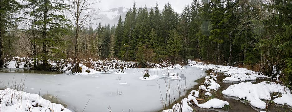 Here a marshy area with beaver dams has ponded and has a skim of thin ice in the cold weather. I had to clamber along downed trees below the road bed to get past all the wetness.
|
| Back to top |
|
|
|
|


