| Previous :: Next Topic |
| Author |
Message |
puzzlr
Mid Fork Rocks


Joined: 13 Feb 2007
Posts: 7220 | TRs | Pics
Location: Stuck in the middle |
|
puzzlr
Mid Fork Rocks
|
 Thu Apr 08, 2021 8:22 pm |
|
|
Most of the time the Duke of Kent is attempted in the winter via a steep gully just north of the summit. But a significant number of those are unsuccessful. Last October (2020) Bryan and I unsuccessfully attempted to climb it in fall conditions with no snow. At that time we attempted the usual south gully, but it got too steep for us. We backed off and made it up the next gully to the north but not without some tense moments near the top. The short story is we got to a high point but were still separated from the summit by the gap of the next gully and what looked like a steep rock scramble. Others have done the gully route without snow, but it looked too hard for us so we descended and exited via the pass at the head of the Alice Creek basin.
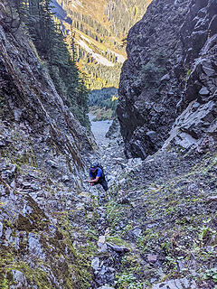 Oct 2020, climbing the gully 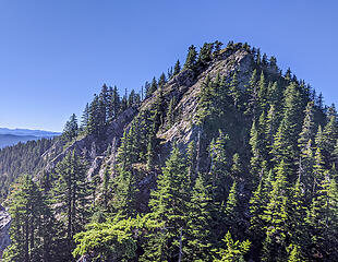 Oct 2020, view of summit from our turn around point 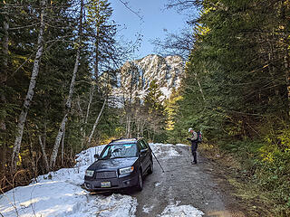 Starting out at the upper McClellan Butte trailhead on FR 9020 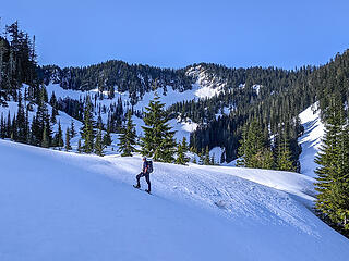 At the big log landing at 3400' and near the end of FR 9020-110. We started early and used snowshoes on the hard crust almost all the way from the car and switched to crampons here. 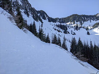 The head of the Alice Creek basin. This bench is the end of FR 9020-110 and in the summer it's a thicket of tall alder. We happily walked right over the top of that mess today. 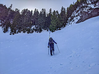 Approaching the ridge at the head of the Alice Creek basin. As usual it's steeper than it looks, but it went easily with the good snow conditions and crampons. 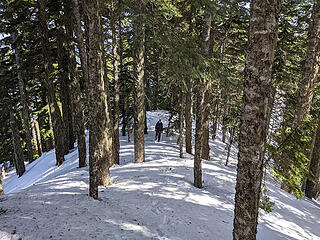 The ridge line back to the Duke started out easy 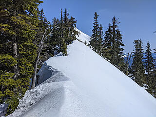 Soon we encountered a gendarme. There was good snow leading up to it on this side, but a 15' drop on the other. We used a hand line to get past that using a convenient small tree growing on top as an anchor. 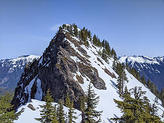 From the top of the gendarme we got a good look at the last part of the route. 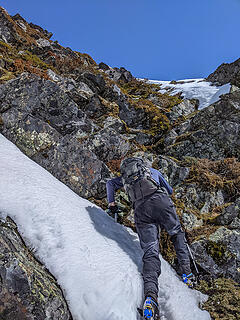 The first part of the ridge was the steepest, with a short 3rd class scramble up these rocks. 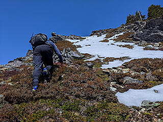 Farther up it was still 3rd class but not nearly as steep and no danger of falling. 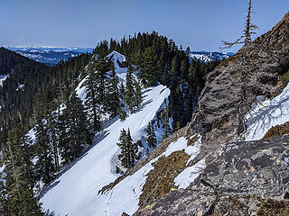 View back to the gendarme on the ridge. On the way down we used a hand line from the tree at right to get down safely. 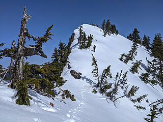 The final 100' to the summit was on easy low angle snow 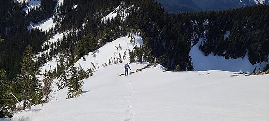 Final steps. Photo by Bryan 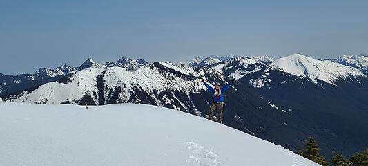 On top. Photo by Bryan 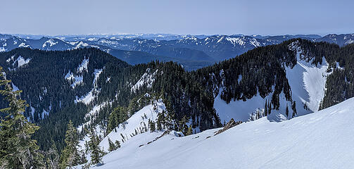 View back along the ridge we climbed 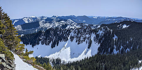 Rock Creek Crags to the east. 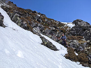 We used a hand line to descent the steep section at the start of the summit block 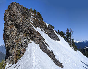 Bryan descending the steep start of the summit block 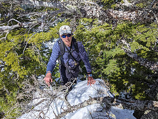 Climbing back up the gendarme using veggie belays 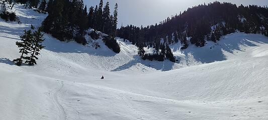 A long snow slide. Photo by Bryan 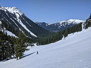 We traversed back to FR 9020. The snow here was still firm enough to walk on without snowshoes -- a good thing because we had left them at the end of the road. 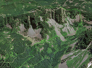 Google Earth view of our route. Ignore the line descending at the summit -- that's a GE elevation model inaccuracy.
|
| Back to top |
  
|
|
awilsondc
Member

Joined: 03 Apr 2016
Posts: 1324 | TRs | Pics
|
Yeahhhh!! Nicely done! 
|
| Back to top |
|
|
Now I Fly
Member
Joined: 07 Jun 2018
Posts: 465 | TRs | Pics
|
Wonderful TR, Monty! Looks like a neat route, and you two timed it perfectly!
|
| Back to top |
|
|
RichP
Member

Joined: 13 Jul 2006
Posts: 5634 | TRs | Pics
Location: here |
|
RichP
Member
|
Thu Apr 08, 2021 9:32 pm |
|
|
Congratulations. I know you've been jonesing for that one for a while. I didn't know about that first attempt. That gully sure looks steep!
|
| Back to top |
|
|
Matt
Tea, Earl Grey, Hot

Joined: 30 Jan 2007
Posts: 4307 | TRs | Pics
Location: Shoreline |
|
Matt
Tea, Earl Grey, Hot
|
Thu Apr 08, 2021 11:52 pm |
|
|
Wish I could have gone with you for this one. Thank you for the route info.
As beacons mountains burned at evening. J.R.R. Tolkien
As beacons mountains burned at evening. J.R.R. Tolkien
|
| Back to top |
|
|
mosey
Member

Joined: 18 Dec 2018
Posts: 163 | TRs | Pics
|
|
mosey
Member
|
Fri Apr 09, 2021 2:04 pm |
|
|
Great trip and nice pics. That area's pretty sweet.
|
| Back to top |
|
|
Justus S.
Member

Joined: 17 Nov 2004
Posts: 1298 | TRs | Pics
Location: WA |
Nice, One of my I90 favorites. I've done the gully twice in February. I would definitely do it again in winter. I still need to get Duchess.
|
| Back to top |
|
|
Snowdog
Member

Joined: 21 Jul 2006
Posts: 1028 | TRs | Pics
Location: on (& off) the beaten path |
|
Snowdog
Member
|
Sat Apr 10, 2021 8:34 am |
|
|
Nice work boyz! 
'we don't have time for a shortcut'
'we don't have time for a shortcut'
|
| Back to top |
|
|
Legionnaire
Member

Joined: 11 Dec 2020
Posts: 7 | TRs | Pics
Location: Seattle |
Hey do you have a GPS route for this a buddy and I just went and attempted this today and I just used screenshots of this thread to try and guide me. I just never really knew if I was in the right part of the basin or what.
Would love to see your exact route to see where we messed up. The weather at the beginning of the day was insane but once we got above 3000 ft it was blue sky's so beautiful!
Thanks! Your trip looks amazing it's crazy to think we went just a few days after but my photos look like it's Feb so much more snow than in your shots.
|
| Back to top |
|
|
neek
Member

Joined: 12 Sep 2011
Posts: 2337 | TRs | Pics
Location: Seattle, WA |
|
neek
Member
|
Sun Apr 11, 2021 3:59 pm |
|
|
Well that looks cooler than I expected. Thanks for the excellent report.
|
| Back to top |
|
|
some names
Member

Joined: 08 Jan 2012
Posts: 244 | TRs | Pics
|
Congratulations on getting to the Duke! Great trip report and photos! The route information is really helpful. Our interest remains high. Being able to attempt has been delayed by an impending knee replacement. Thanks for the great info!
somesignaturehere and somesignaturethere
somesignaturehere and somesignaturethere
|
| Back to top |
|
|
puzzlr
Mid Fork Rocks
Joined: 13 Feb 2007
Posts: 7220 | TRs | Pics
Location: Stuck in the middle |
|
puzzlr
Mid Fork Rocks
|
Mon Apr 12, 2021 10:47 am |
|
|
| Legionnaire wrote: | | do you have a GPS route for this |
I just added a GPS track on peakbagger. Were you having trouble following the roads or farther up in the basin? And, yes, we seem to be getting a steady diet of late season snow higher up.
|
| Back to top |
|
|
BensonM
Member

Joined: 23 Mar 2021
Posts: 22 | TRs | Pics
Location: seattle, wa |
|
BensonM
Member
|
Mon Apr 12, 2021 12:18 pm |
|
|
Well done. That gendarme looks like it added a little spice on the ascent. Were you able to determine whether it was corniced at a glance -- or only after you secured the hand-line for a closer inspection?
|
| Back to top |
|
|
puzzlr
Mid Fork Rocks
Joined: 13 Feb 2007
Posts: 7220 | TRs | Pics
Location: Stuck in the middle |
|
puzzlr
Mid Fork Rocks
|
Mon Apr 12, 2021 1:56 pm |
|
|
On the side we approached from there was melted out rock that led to the top (~ 20'). We went up there to see what was ahead. Just beyond it's back to a normal rounded ridge in the trees. It's not that big, but the slope falls off too quickly in one spot to arrest so we used a hand line for security.
|
| Back to top |
|
|
BarbE
Member

Joined: 28 Jul 2006
Posts: 1153 | TRs | Pics
|
|
BarbE
Member
|
Mon Apr 12, 2021 7:31 pm |
|
|
| puzzlr wrote: | Bryan descending the steep start of the summit block |
The gnarly less hospitable side of the royal house. 😁
|
| Back to top |
|
|
|
|


