| Previous :: Next Topic |
| Author |
Message |
Boondocker
Member


Joined: 07 Jun 2021
Posts: 4 | TRs | Pics
Location: Greater Portland |
Where: Mt St Helens - Loowit Trail from Marble Mountain Sno Park
When: Memorial Weekend - Friday, May 28 thru Monday, May 31 2021
Distance: 32.9 mi - loop
Conditions: Misty and damp morning of first day, sunny with minimal clouds rest of the trip with highs in the 60s-80s and lows in the 30s-40s
Lighterpack: https://lighterpack.com/r/1rzjq1 Initial pack weight was about 24 lb (5'6" 130 lb F) & 29 lb (6' 175 lb M) with all our food, water and snowshoes.
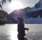
Overview: It was pretty evident no one had used much of the trail before us in the past week+ other than mountain goats and therefore required quite a bit of route finding much of the trail. The south half of the trail was about 85% snow covered above 4k ft between South Toutle River and Windy Pass - much of this section we gave up trying to follow the trail and just followed its general direction. Snow was pretty consolidated with a light layer of slush on top though post holing was an issue when we hit the rocky areas. Water was plentiful on the east (fill up at trailhead/June Lake, gullies, then the creek just south of Windy Pass) and north parts of the trail (lots of running water here) but on the southwest side Toutle and Blue Lake Wash (very silty) were the only sources of running water until we got to the Wormflow Winter Climbing Route. Hiking sticks are a must, additional traction (we used snowshoes) highly recommended. Sun protection is also a must if it's sunny - we got pretty sun burned even with ample sunscreen, sun gaiters, sunglasses and hats. I also swear my finger tips, which weren't covered, are now at least 5 shades darker than any other part of me. Also highly recommend going CCW so you can slide down most of the gullies while there's still enough snow. Finally, prepare to snow camp on the south side unless you plan on heading below 4k ft to camp.
All in all it was a fun challenge that I felt we were well equipped for (no ice axe needed!). Mostly it was more mentally challenging than physically but we did take our time since we had 4 whole days to burn and took ample pictures and videos (that is until the GoPro decided to corrupt the SD card -_- ugh). I'd be interested in seeing what the trail looks like in the summer/fall without all the snow but not sure I'd be able to convince Mr. SureFoot to do it with me again...maybe if I bring it up after a few months...
The Report:
Day 1 - 7.84 mi, 2,600 ft to 4,194 ft - Parking Lot to Ape Canyon
Had a bit of a late start waiting for the weather to clear up even though we'd gotten there the night before. Took the Wormflow Winter Climbing Route up then veered right on Pika to June Lake. Scrambling through the bolder field was a bit difficult with our heavy packs and limited visibility with the mist. We probably didn't follow the path but made it to June Lake no issues. Above June Lake, there's a portion of the trail that's heavily damaged by a very large partially rotted tree. Not too difficult to get past but did require extra scrambling and the trail looked to be in sad shape. Said hello to a pika while trying to follow old footprints in the snow for Loowit trail until we got out of the forest, then there were no footprints to follow and we strapped on our snowshoes and went the general direction of the trail. Lots of gullies butt sliding down the south and scrambling up the snow-less north sides. Only one was of note with terrible traction. Hopefully later in the season when it's been more heavily trafficked it won't be so bad but we had a heck of a time trying to get up this one. Even on all fours we were still slipping and sliding with plenty of cuts and bruises to take home as souvenirs. Needless to say, Mr. SureFoot was not pleased with this one and questioned our ability to complete the loop after this scramble. Thankfully a warm meal and good nights rest raised moral enough for us to continue. The alternative would have been to take Ape Canyon down and walk the road back to the parking lot. There were a few snow free spots near the Ape Canyon junction there were completely unprotected but we opted for a snowy site sheltered by trees instead.
Day 2 - 11.18 mi, 4,194 ft to 3,187 ft - Ape Canyon to South Fork Toutle River
Woke up to a beautiful clear blue sky and a herd of goats grazing on Pumice Butte. Packed up the tent, strapped on the snowshoes, and headed north. Only tracks to the Plains of Abraham were a few left by goats but we decided to take a more direct route with less climbing. Once at the plains it was quite evident no one had passed through the area since the last snowfall though there were plenty of old ski tracks about. Filled up on water just south of Windy Pass. Climbed up the pass in snowshoes then packed them away once we hit the trail. Once at the top, we could see the trail down the pass was sprinkled intermittently with patches of steep snow which didn't suite our fancy so we decided to slide down the pass instead and intersect it at the bottom. This proved to be the right choice. Minimal snow the rest of the day though it was quite the long slog with the full sun. Also encountered our first humans of the trip aside from the trailhead when we got to the Loowit Falls area. Plenty of running water this part of the trail though had to to watch out for snow bridges.
Past the lava flows we followed a set of old tracks to just above the massive switchback above South Fork Toutle. Probably the most grueling part of the whole trip due to the sun with only one scramble of note, not as bad as the first day but we had to take it slow and be careful with our footing in the loose red clay. Once at Castle Ridge, the footprints we were following took the ridge down instead of the switchback. Not sure what happened to them as we never saw those same prints again. Instead, we followed the switchback down - super sandy in spots but not too terrible. We were definitely ready for dinner though once we got to the river.
Day 3 - 7.28 mi, 3,187 ft to , 4,812 ft - South Fork Toutle River to Butte Camp Trail
Man have I forgotten what camping on bare ground feels like. It was quite warm and I was fine with just my CCF pad. In the morning we washed up at the river before packing up and heading out. We continued on the Loowit and put snowshoes back on once we got about ~4k ft until we came back down again at Blue Lake Wash (it all made sense why there was a massive jut in the trail after seeing this section). Used the provided ropes to get down then back up again, then snowshoes back on for the most part until we found a nice sheltered area near the Butte Camp intersection. It was also at this point that we started passively melting snow. In hindsight we should have filled up more at Blue Lake Wash even though the water was a bit silty. It was also at this point that we discovered that the Smartwater bottle that we'd filled at the wash had gone missing. Oops. Must have fallen out of my bag during one of our many butt slides of the day. We did pickup a bottle on the second day so I guess it evens out...
Day 4 - 6.6 mi, 4,812 ft to 2,600 ft -Butte Camp Trail to Parking Lot
Lots of route finding through the snow and butt sliding down gullies. Saw our first marmot of the season sunning itself, flat as a pancake. Almost mistook it for a martin it looked that skinny. Just past Swift Creek Flow we bumped into another couple attempting to backpack Loowit CW but hadn't been anticipating so much snow and were looking to bail down Butte Camp instead. Hopefully they made it alright. Per their recommendation though, we decided to stay above tree line where navigation was easier and hit straight across to the Wormflow Winter Climbing Route instead of taking the forested switchback down on Loowit. Turned out pretty well though we did startle a climber as we butt slid our way down to the route and both of us ended up with a few additional holes in the bum area. I'll need to make sure to add extra reinforcements to our rears next time.  All in all a successful trip and I'm more than antsy to get out again but it probably won't be until the end of the month. Anyone got recommendations for 2 nighters within 4 hours of Portland? Snow isn't really an issue for us though preference would be nothing so steep that ice axes would be required.
 cryptobrian, KascadeFlat cryptobrian, KascadeFlat
cryptobrian, KascadeFlat |
| Back to top |
  
|
|
KascadeFlat
Member
Joined: 06 Jul 2020
Posts: 320 | TRs | Pics
Location: Eating peanut M&Ms under my blue tarp |
Great write up, Boondocker!  I hear the Loowit trail is a dry and dusty adventure in the summer/fall and it's interesting that you ran into water challenges even in the spring. I don't think I have seen a spring trip report yet so I appreciate the insight into the conditions. I hear the Loowit trail is a dry and dusty adventure in the summer/fall and it's interesting that you ran into water challenges even in the spring. I don't think I have seen a spring trip report yet so I appreciate the insight into the conditions. 
For a good time call: 1-800-SLD-ALDR.
For a good time call: 1-800-SLD-ALDR.
|
| Back to top |
|
|
Boondocker
Member
Joined: 07 Jun 2021
Posts: 4 | TRs | Pics
Location: Greater Portland |
Thanks! I didn't find many winter/spring reports for Loowit when research this trip either, aside from back in 2015 when they had an unusually low snow pack. I guess it's understandable seeing how adverse most are to snow camping.
The ranger also noted that they don't get around to cleaning up Loowit until July/August when we had called about conditions before the trip.
Also, it took a while, but here are pictures:
http://imgur.com/gallery/LaifdFK
|
| Back to top |
|
|
General ****
Member
Joined: 26 May 2014
Posts: 167 | TRs | Pics
Location: Clark County, SW WA |
Thank you for your report, looks like a great trip! ... and nice photos on the other site.... thanks.
The General primarily backpacks solo.
The General primarily backpacks solo.
|
| Back to top |
|
|
|
|
You cannot post new topics in this forum
You cannot reply to topics in this forum
You cannot edit your posts in this forum
You cannot delete your posts in this forum
You cannot vote in polls in this forum
|
Disclosure: As an Amazon Associate NWHikers.net earns from qualifying purchases when you use our link(s). |


