Forum Index > Trip Reports > Horseshoe & Buckner - 7/25/21
 Reply to topic
Previous :: Next Topic
Author Message
vk
Member
Member


Joined: 28 Jul 2021
Posts: 9 | TRs | Pics
Location: Washington
vk
Member
PostWed Jul 28, 2021 11:25 pm 
When I was preparing for this trip I wasn't able to find too much beta on later season (low snow cover) ascents of Horseshoe or Buckner, so I thought I'd write up some beta. With the heat dome this year, current conditions probably resembled even later season conditions than usual years. I found Eric G and Fletcher's posts to be most helpful in terms of understanding and navigating the route. We utilized a handful of GPS tracks on Peakbagger as well. As we headed from Sahale Glacier Camp towards Horsehoe basin we had to get from rock/slabs onto the terminus of the Sahale Glacier. Getting from the rock to snow in this section was luckily pretty easy. There was some undercut snow but overall, it was easy to transition. There was a huge waterfall flowing underneath this section of snow, but the there was plenty of coverage to safely cross over the waterfall.
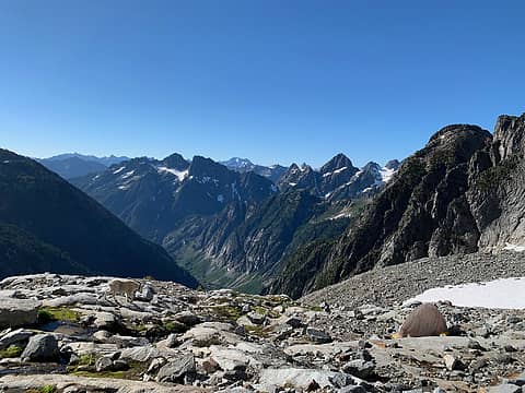
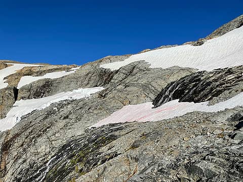
Taken from the rock rib, looking up at the upper snowfield, which we descended. Sahale Glacier Camp is beyond the top of the rock in the middle of the photo.
We reached the rock rib and began the descent. It was easy to pick our way down as there was a semi-obvious boot path. Fletcher's report clearly describes this rock rib and we found it really helpful. We reached the snow tongue and found it had broken up a bit, but it was still easy to get on top of it to downclimb. The snow was relatively hard at 8:30am and required a few extra kicks (for me) to get some secure steps in. As we descended down the snow tongue we noticed another party's previous tracks higher up near the top lip of the moat. It appeared they avoided the top of the snow tongue by descending the scree in the gully, then climbed up over the moat onto the snow.
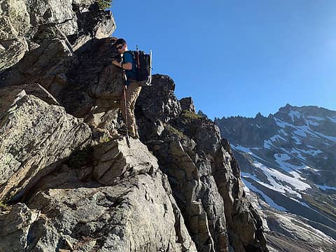
An exposed move coming down the rock rib
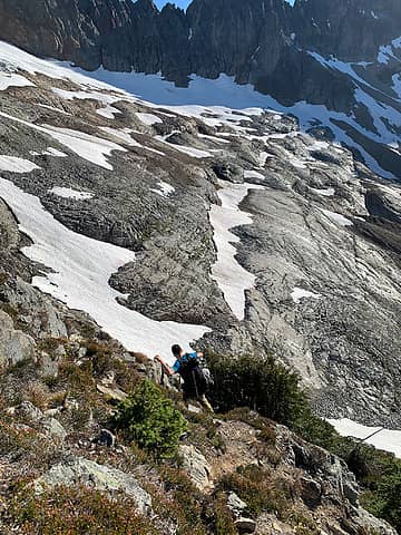
A look into the upper basin while descending the rock rib
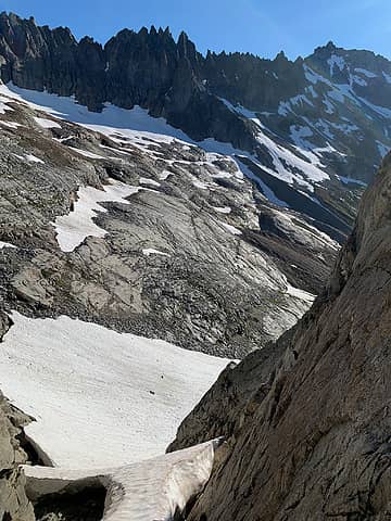
Snow finger
Snow finger
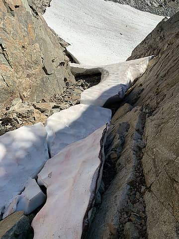
Top of snow finger a bit broken up
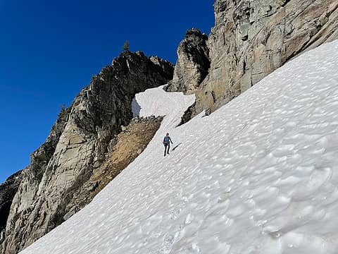
Looking back at the snow finger
Once we reached the basin we were able to clearly see just how melted out it was. Luckily the slabs in the basin were really easy and quick to navigate. There were some sections where the snow melt coming from above caused heavy enough of a flow that it felt slightly unsafe to cross given some rocks were slippery and it was hard to see what we would've been stepping on, and the fall could take us over the edge of the slabs onto more slabs. We were able to traverse across snow instead when the flow of water was a bit too strong, but there is potential that some of those snow patches would turn into precarious snow bridges. If the flow of water wasn't too strong we opted to just cross through the water. I was afraid some of the rock would be really slippery but found that only some parts of the rock/slab were slippery; most were still grippy despite water flowing right over.
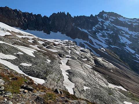
Looking into the upper basin towards Buckner. We traversed on the lower slabs in the middle/right of the photo.
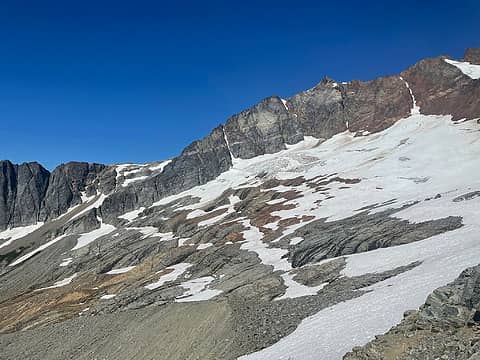
Looking back towards Sahale. We traversed the lower slabs in the middle/left of the photo. You can also see the snow tongue
Travel up to the old mine was pretty easy going, but after the mine we had to traverse across more snow and more scree. The scree on the traverse really wasn't too bad. When we were pretty much due south of Horseshoe we began to ascend up pretty annoying scree. There was no more snow at this point so scree was the only option. It reminded me a bit of ascending Saska. Eventually we reached the snowfield below Horsehose Peak (marked on the USFS). We hopped onto the snow and up to the rock where we'd be met with a bit more scree. We scrambled up the scree onto more solid rock and followed an obvious ledge heading left. Following this ledge, we wrapped around a corner into a dirt-filled gully, and scrambled to the base of the climb.
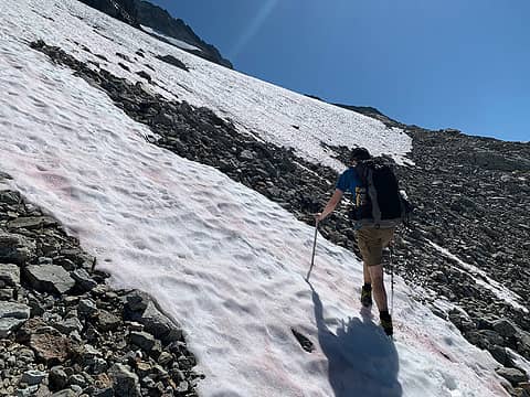
Some of the snow/talus after the mine
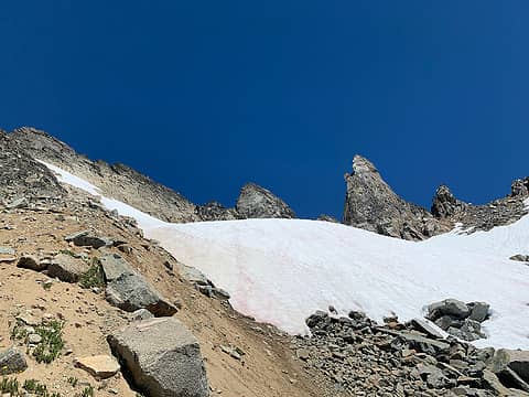
Snowfield below Horseshoe. We ascended the scree-y rib up to this snowfield shown on the left side of the photo
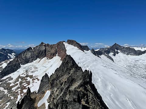
Looking towards Sahale from the summit
I didn't find much beta on what pro people brought so thought I'd share. I read one report on Peakbaggers that they used a .3 and .4, so we brought cams from .2-.5 just to be safe, and were able to find placements for all. The pitch follows a pretty easy ledge and feels class 4 (maybe?) until you are right at the summit and need to pull the one class 5.something move. I found there are thin feet but good hands (look for the smooth, light gray rock right in the notch that you climb through). After an awkward move we reached the summit! There is a ton of tat to rappel off of. We found one that we trusted (yellow with black? stripes) and put our rope through that one and the rest for good measure. Getting off the summit was awkward and I was glad to have a PA. We brought a 30m rope and our "rappel" was more of a backwards walk down the ledge back to the start of the climb. A 60m rope would get you down to the dirt-filled gully. We were glad to have saved the weight with our 30m as the downclimb down the gully was pretty simple, especially by leveraging the rock wall on the skier's left.
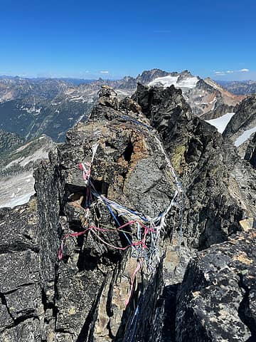
CF of tat on the summit
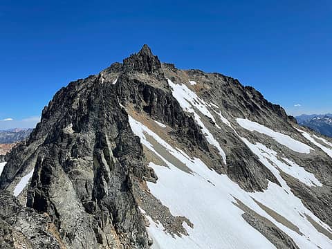
Looking towards Buckner. We traversed the large snow field shown over to the rock to the right of the snow finger (just right of the middle of the photo)
We descended back to the snowfield below Horsehoe and traversed the snow towards Buckner. We reached the base of a snow finger but rather than ascending snow, we ascended the rock just on the right of the snow finger. It was pretty solid, but once atop the rock, we were met with more annoying scree and talus. We then had to ascend a small bit of snow. Eventually we made it to the summit block of Buckner and found an easy and solid route up to the summit.
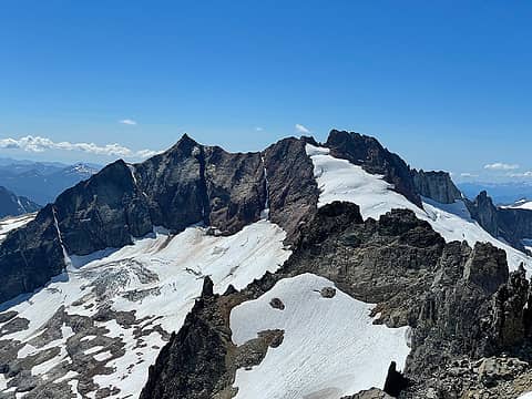
Looking towards Horseshoe from Buckner. We traversed the snow patch shown in the foreground
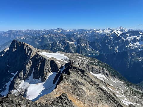
Looking towards Booker
We initially descended the scree/talus coming off Buckner but eventually got tired of it and decided to hop onto the snow for the remainder. It was pretty steep and getting soft in the heat, and our topo showed it was 35-46* which felt about right. We made it back to the scree we ascended earlier and traversed back over the slabs to the snow tongue. The snow tongue was still surprisingly hard by the evening, we suspect it was because of some cold winds coming through and the shade that had set over the snow tongue a while before we reached it. We initially began kick steps to ascend, but then decided to try and hop over the lip of the moat into the gully to avoid the very top portion of the snow tongue. The moat was a bit tricky and required a full-on straddle plus a stem of the foot to the rock, but it went. If there had been more space between the snow and the rock, it would've been a trickier move. The rest of the route back to Sahale Glacier Camp was uneventful. We were happy to have been able to camp at the Glacier Camp (on the outer edge close to the rock rib - to avoid the crowds). For those who don't want to C2C these peaks but can't get a Sahale Glacier Camp permit, there are plenty of flat spots to bivy down in the upper basin where/if the slabs are melted out. The first bivy spot we found was right after the snow tongue. We saw other bivy spots along the way as well, before reaching the 6900' rock promontory. While it may have been nicer to avoid the scree by having more snow coverage on the route, the scree and talus wasn't any worse than other cascadian choss I've experienced, particularly on bulgers. I saw posts on Facebook and other sources discouraging a late season choss fest, which may be true for those who are scree-adverse, but I personally didn’t mind too much. Plus, the upper basin area is stunning with less snow winksmile.gif We also saw one lone goat in Horseshoe basin! It looked at us curiously, as if it wasn't used to seeing humans. We saw him hanging around this tent on the way in, and saw it again at the tent on the way out, observing the humans by the tent eating dinner. As we ascended the snow tongue to get out of the basin, we turned around and were surprised to see the goat following us!! It came up to rock rib and scrambled around some rocks, as if trying to appear busy while secretly spying on us. It eventually turned around and left as we ascended higher up the rib. It was also wearing a collar, which we assumed was for research...but that's the first time we ever saw a collar on a goat.
You can hardly make out the collar in the photo

Bluebird, ozzy, zimmertr, Dave Weyrick, Tom, reststep, flatsqwerl, RichP  ngie, awilsondc
Back to top Reply to topic Reply with quote Send private message
rbuzby
Attention Surplus


Joined: 24 Feb 2009
Posts: 1011 | TRs | Pics
rbuzby
Attention Surplus
PostThu Jul 29, 2021 9:58 am 
Nice pics, looks like a cool trip. I wonder if the goat with the collar was relocated from the Olys.

Back to top Reply to topic Reply with quote Send private message
   All times are GMT - 8 Hours
 Reply to topic
Forum Index > Trip Reports > Horseshoe & Buckner - 7/25/21
  Happy Birthday Traildad!
Jump to:   
Search this topic:

You cannot post new topics in this forum
You cannot reply to topics in this forum
You cannot edit your posts in this forum
You cannot delete your posts in this forum
You cannot vote in polls in this forum