| Previous :: Next Topic |
| Author |
Message |
jupsal
Member


Joined: 20 Aug 2017
Posts: 49 | TRs | Pics
|
|
jupsal
Member
|
 Fri Aug 20, 2021 12:25 pm |
|
|
This post is now 1 month overdue, as this trip took place on July 20-23. My friend @Triad (of which many [all?] of these pics are due to him and his fancy newer iPhone than mine) and I went out to do an overnight at Price and Easy, with a drive between the trailheads. Admittedly I don't have a lot to add to previous reports, but I really wanted to use this title that I came up with. At least I'll have something to say about finding water (at that time, which should say something about water now!).
Price
We got a bit of a late start (left TH at 5:30). Crossing the North Fork Nooksack (the later crossing, not at the TH) was fun, the water was running high (I am 5'6" for comparison).
The crossing was a lot warmer at 7pm going in than at 12:30pm going out the next day. Go figure, a few hours really warms up that cold cold creek. Finding the flagging towards the Price trail was nontrivial after crossing at the most obvious spot (the old log crossing is long gone). We had to romp SE a bit to get to the flagged route. It begins on the SW side of the river right where the trail changes from flowing NW to straight N. The walking up the flagged route was pretty straightforward, the flagging is mostly very good. Still plenty of bushwhacking. Plenty of good water along the way. The lake was fantastic and kept getting better as we walked up the moraine. We found an.... interesting place to camp on the edge of the trees N of the moraine.
The next morning we walked up the moraine more and went down towards the lake to explore the ice, but not before stopping on some slab to snack and stare.
We traced our steps back out, drove to the next trailhead, and began hiking around 2:30.
Easy
The hike to the turnoff is straightforward. After crossing the Chilliwack which was low (and lived up to its chilly name, brr), we had to hike W a bit to the cairned route up towards the ridge. The route was easy to follow, but brushier than I expected. No wasps. The main piece of beta here is that many of the tarns on the ridge are dried out. We were following TRs from September of previous years and it seems like many of the tarns that were wet then were dry in July this year. Yikes. Higher up there were good tarns (including at some of the very popular camping spots), but certainly fewer than I expected. We camped at one of these popular spots, after watching fire come through the clouds at night.
The next morning we liesurely explored the ridge and went down to Easy lake.
We decided to work our way towards perfect pass.
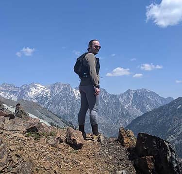
After getting to the Impasse we decided we'd had enough and better head back to camp, sad to not make it to Perfect but happy with our perfect views of the pickets and beyond  There was plenty of boulder-field-traversing to be had on the way back. Typically I love this stuff. This time I put my hand on a small little rock above, which triggered a big rock, about the size of my torso, to slide down right at me. I was able to push against it, sliding for a bit with it, and eventually push it and myself in opposite directions. There was plenty of boulder-field-traversing to be had on the way back. Typically I love this stuff. This time I put my hand on a small little rock above, which triggered a big rock, about the size of my torso, to slide down right at me. I was able to push against it, sliding for a bit with it, and eventually push it and myself in opposite directions.  that was a close one. We both had quite a lot of adrenaline pumping after that and needed a minute to cool down before continuing on.
We spent lots of time sitting and gazing on the ridge before heading back down to our campsite below.
The next day we walked out, retracing our steps from before, without any difficulties. Overall we ran into ~9 rangers, not 1 asked to see our permits! that was a close one. We both had quite a lot of adrenaline pumping after that and needed a minute to cool down before continuing on.
We spent lots of time sitting and gazing on the ridge before heading back down to our campsite below.
The next day we walked out, retracing our steps from before, without any difficulties. Overall we ran into ~9 rangers, not 1 asked to see our permits!
 hapemask, zimmertr, raising3hikers, fourteen410, jaysway, olderthanIusedtobe, awilsondc, RichP, reststep, Tom hapemask, zimmertr, raising3hikers, fourteen410, jaysway, olderthanIusedtobe, awilsondc, RichP, reststep, Tom
hapemask, zimmertr, raising3hikers, fourteen410, jaysway, olderthanIusedtobe, awilsondc, RichP, reststep, Tom |
| Back to top |
  
|
|
jaysway
Member

Joined: 16 Jul 2020
Posts: 347 | TRs | Pics
|
|
jaysway
Member
|
Fri Aug 20, 2021 4:32 pm |
|
|
I knew exactly which lake you were going to when I saw Price in the title  this has been on my list for a long time, even since "discovering" it on maps and wondering why more people did not visit it. Then, after doing my research I realized how it is difficult to access, but still I do not think that many outside of this kind of community know it exists. Your pictures are beautiful and make me want to move this closer to the top of my list this has been on my list for a long time, even since "discovering" it on maps and wondering why more people did not visit it. Then, after doing my research I realized how it is difficult to access, but still I do not think that many outside of this kind of community know it exists. Your pictures are beautiful and make me want to move this closer to the top of my list  . .
|
| Back to top |
|
|
Malachai Constant
Member

Joined: 13 Jan 2002
Posts: 16092 | TRs | Pics
Location: Back Again Like A Bad Penny |
Went up to Whatcom pass Wednesday Challenger GLACIER is trashed schrund gone. Couple headed to climb Whatcom peak route largely talus and scree. Ruth route closed.
"You do not laugh when you look at the mountains, or when you look at the sea." Lafcadio Hearn
"You do not laugh when you look at the mountains, or when you look at the sea." Lafcadio Hearn
|
| Back to top |
|
|
jupsal
Member
Joined: 20 Aug 2017
Posts: 49 | TRs | Pics
|
|
jupsal
Member
|
Fri Aug 20, 2021 5:33 pm |
|
|
valleyjo |
| Back to top |
|
|
jupsal
Member
Joined: 20 Aug 2017
Posts: 49 | TRs | Pics
|
|
jupsal
Member
|
Fri Aug 20, 2021 5:35 pm |
|
|
| Malachai Constant wrote: | | Went up to Whatcom pass Wednesday Challenger GLACIER is trashed schrund gone. Couple headed to climb Whatcom peak route largely talus and scree. Ruth route closed. |
Largely Talus and Scree from which direction? I thought it always was from Perfect Pass.
|
| Back to top |
|
|
zimmertr
TJ Zimmerman
Joined: 24 Jun 2018
Posts: 1224 | TRs | Pics
Location: Issaquah |
|
zimmertr
TJ Zimmerman
|
Sat Aug 21, 2021 7:15 am |
|
|
Price has been on my to do list for two years! Thanks for the beta. Maybe I'll check it out in the last week of August.
|
| Back to top |
|
|
carlb328
Member
Joined: 28 May 2007
Posts: 327 | TRs | Pics
Location: Yakima, WA |
|
carlb328
Member
|
Sat Aug 21, 2021 8:48 am |
|
|
I may have to try that hike and scout the river for fishing. I doubt there's any in the lake.
|
| Back to top |
|
|
hapemask
Member

Joined: 17 May 2021
Posts: 29 | TRs | Pics
|
|
hapemask
Member
|
Sat Aug 21, 2021 10:28 pm |
|
|
Thank you for sharing this, particularly the photo of you crossing the river and including your height! Ive tried (and failed) twice to get to that lake this season. The first time was during the heat dome when river flow was abnormally high, and there was no chance of crossing. I came back a second time a few weeks later and it was lower, but I still didnt feel comfortable crossing it alone. Ill definitely be back though, thats far less deep than I was expecting it to be looking down from the bank. 3rd times the charm
|
| Back to top |
|
|
D. Inscho
Not bored yet...

Joined: 28 Feb 2010
Posts: 973 | TRs | Pics
Location: Bellingham,WA |
|
D. Inscho
Not bored yet...
|
Tue Aug 24, 2021 7:47 am |
|
|
Very nice. Fond memories of Easy. Well done trip to Price.
http://david-inscho.smugmug.com/
The key to a successful trip is to do the planning during work hours. -- John Muir
My most memorable hikes can be classified as 'Shortcuts that Backfired'. --Ed Abbey
http://david-inscho.smugmug.com/
The key to a successful trip is to do the planning during work hours. -- John Muir
My most memorable hikes can be classified as 'Shortcuts that Backfired'. --Ed Abbey
|
| Back to top |
|
|
brewermd
Member
Joined: 02 Jun 2008
Posts: 159 | TRs | Pics
|
|
brewermd
Member
|
Tue Aug 24, 2021 6:47 pm |
|
|
I like Price, I try to visit each year. I found crossing at where the flagging for the trail across the river is is for me the best spot.
Know I want to go check out Perfect!
|
| Back to top |
|
|
|
|
You cannot post new topics in this forum
You cannot reply to topics in this forum
You cannot edit your posts in this forum
You cannot delete your posts in this forum
You cannot vote in polls in this forum
|
Disclosure: As an Amazon Associate NWHikers.net earns from qualifying purchases when you use our link(s). |


