Forum Index > Trip Reports > Steel Creek bushwhack (Olympics), 8/21/21
 Reply to topic
Previous :: Next Topic
Author Message
ForbinsAscent
Member
Member


Joined: 29 Jun 2018
Posts: 26 | TRs | Pics
Location: WA
ForbinsAscent
Member
PostSun Aug 22, 2021 5:52 pm 
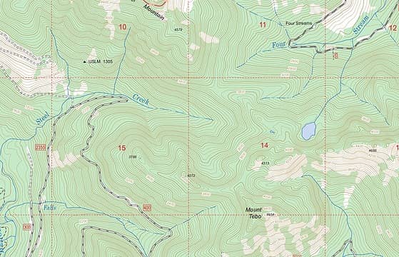
In need of an obscure, old-growth bushwhack, I decided to follow Steel Creek in the SE Olympics, up to the lake you can see on the map below. I drove to the highest point I could, following FS 2355 up the S. Fork Skok, past Lebar Horse Camp. It keeps going up the river for miles until it finally makes a switchback by Steel Creek. I almost made it to that switchback, but a Honda Accord was stuck in one of the deep water bars (and temporarily abandoned) blocking the road. I parked off of the road just below it. The last mile or two of that road before the switchback requires high clearance due to water bars, but otherwise it's in great shape. And by the time you get to the switchback, it's all old growth.
map
map
From the switchback, I started up stream left for maybe a quarter mile or more. Little evidence of any path there except for a few shards of very old, brittle red flagging on the ground in a couple of places. But that soon ended; maybe they just gave up? There was a fair amount of blowdown, which was the only real obstacle at that point, but not nearly as much as I observed on the other side of the creek. After some time, I noticed Steel Creek was dry for a stretch and so I just walked up the streambed for the next quarter mile or so. I should note there was a good amount of devil's club the whole way.
Then a little further, the stream valley narrowed and there was a clear elk trail on stream right. I've learned the elk always know how to get there. If you are on an elk trail and it deviates from where you think you want to go, just trust it. They've been doing it for years. Steel Creek then entered a narrow gorge, with the elk trail well above it. Then, the stream emerged from the gorge at a headwall. Probably at least a hundred feet high, with several cascading waterfalls. Very hard to capture it all in one photo. You could certainly scramble down to the base, but I didn't.
After the headwall, my route got steeper and I lost the elk trail, so just bushwhacked up eventually coming to mossy cliffs and boulders. Soon there were some rocky areas where there would presumably be some great views if one was not inside a cloud.
On one of these exposed rocks I found the only sign of humans (other than the few bits of old flagging) that I found between the road and the lake.
A little further I got to two small ponds.
Then up and over a ridge and down to the lake:
It was not fishing weather. I tried a few casts, but luckily fishing was not my motivation for the hike. The clouds did clear for a minute before I left the lake.
On the way out I discovered the best way is to head due west to the little pond on the map, then head NW along a good elk trail that follows the ridge. After a bit, you can drop down to rejoin the other good elk trail all the way back to Steel Creek. I did notice an unusual tree on the way.
Except for a couple of yellow jacket stings on the way down, it was a great day. And the Accord was gone when I got back to my car. This route presents an interesting connection between the S. Fork and N. Fork of the Skokomish, without having to gain a ton of elevation, like you would if you went through Wonder Mountain. From where I ended my hike at the lake, you can "easily" get down to Road 2451 (out of Lake Cushman). That road is currently closed (Road Closed sign) due to a landslide, although a FS ranger said I was welcome to drive up as far as I could. I would say about 3 hours bushwhack one-way (maybe 2.5 if you are fast and knew the route) from road 2355 to 2451. But then again, there is some cool stuff to see, so why hurry?

silence, Walkin' Fool, meck, Dave Weyrick, KascadeFlat, reststep, RichP, awilsondc
Back to top Reply to topic Reply with quote Send private message
Silas
Member
Member


Joined: 14 Aug 2012
Posts: 77 | TRs | Pics
Silas
Member
PostSun Aug 22, 2021 7:09 pm 
This is a great report. Thanks!

Back to top Reply to topic Reply with quote Send private message
RAW-dad
Member
Member


Joined: 07 Jul 2017
Posts: 119 | TRs | Pics
Location: Oregon
RAW-dad
Member
PostSun Aug 22, 2021 8:04 pm 
What's Old Growth without some Devil's Club? Thanks for sharing!

Back to top Reply to topic Reply with quote Send private message
RodF
Member
Member


Joined: 01 Sep 2007
Posts: 2593 | TRs | Pics
Location: Sequim WA
RodF
Member
PostSun Aug 22, 2021 11:31 pm 
Neat adventure! Especially appreciate your photo of Steel Creek Falls. Thanks for sharing up.gif

"of all the paths you take in life, make sure a few of them are dirt" - John Muir "the wild is not the opposite of cultivated. It is the opposite of the captivated” - Vandana Shiva
Back to top Reply to topic Reply with quote Send private message
meck
Member
Member


Joined: 31 Dec 2010
Posts: 920 | TRs | Pics
meck
Member
PostMon Aug 23, 2021 6:04 pm 
Very cool adventure. I'd been there via the "easy way" a few years back and wondered what it was like over that shoulder to the west. Thank you for posting this.

*Just say NO to Rent-Seeking, don't give up the concept of "ownership"*
Back to top Reply to topic Reply with quote Send private message
   All times are GMT - 8 Hours
 Reply to topic
Forum Index > Trip Reports > Steel Creek bushwhack (Olympics), 8/21/21
  Happy Birthday Crazyforthetrail, Exposed!
Jump to:   
Search this topic:

You cannot post new topics in this forum
You cannot reply to topics in this forum
You cannot edit your posts in this forum
You cannot delete your posts in this forum
You cannot vote in polls in this forum