| Previous :: Next Topic |
| Author |
Message |
CS
Member


Joined: 04 Apr 2022
Posts: 176 | TRs | Pics
|
|
CS
Member
|
 Fri May 20, 2022 4:02 pm |
|
|
Anyone know good places to go to hike or camp where it's not going to be a sh## show of traffic? 
|
| Back to top |
  
|
|
Seattle_Wayne
Member
Joined: 12 Nov 2019
Posts: 104 | TRs | Pics
Location: Greater Snohomish County |
Nope. Best bet is to stay home.
|
| Back to top |
|
|
Bootpathguy
Member
Joined: 18 Jun 2015
Posts: 1788 | TRs | Pics
Location: United States |
A many folks here would answer "yes" but they are not going to tell you.
Edit your request asking for a response / suggestion via "private message"
Experience is what'cha get, when you get what'cha don't want
 zimmertr zimmertr
Experience is what'cha get, when you get what'cha don't want
zimmertr
|
| Back to top |
|
|
Randito
Snarky Member

Joined: 27 Jul 2008
Posts: 9512 | TRs | Pics
Location: Bellevue at the moment. |
|
Randito
Snarky Member
|
Fri May 20, 2022 7:58 pm |
|
|
Bathtub Lakes obviously.
Also it's going to rain -- as it always does on Memorial Day weekend in Washington.
 zimmertr zimmertr
zimmertr |
| Back to top |
|
|
zimmertr
TJ Zimmerman
Joined: 24 Jun 2018
Posts: 1224 | TRs | Pics
Location: Issaquah |
|
zimmertr
TJ Zimmerman
|
Fri May 20, 2022 9:19 pm |
|
|
I've got the whole week off. Kinda bummed about the snow conditions right now. Would have loved to do a big loop in the Teanaway or something.
What should I do with all that time? Fly somewhere else?
|
| Back to top |
|
|
CS
Member
Joined: 04 Apr 2022
Posts: 176 | TRs | Pics
|
|
CS
Member
|
Sat May 21, 2022 12:56 am |
|
|
Re: PM, Yeah Im not expecting anyone to share their secrets, was just thinking there might be some general areas Memorial Day crowds skip.
Re: Bathtub no doubt will have someone up there I bet. I saw some video where a guy mount biked for like 8mi, then hiked for some pretty painful distance up to very isolated fire look out. And of course there was a couple in the look out. So after all that, just like being in a youth hostel.
Re: weather, last weekend the whole state was covered in clouds pretty much. On a long shot, I tried just looking at the sat images for where clouds were evaporating and then went there. Amazingly it worked out perfectly, despite the imagery being a few hours behind. Had a little sunny valley pretty much to my self to explore and hang out in.
|
| Back to top |
|
|
neek
Member

Joined: 12 Sep 2011
Posts: 2336 | TRs | Pics
Location: Seattle, WA |
|
neek
Member
|
Sat May 21, 2022 5:16 am |
|
|
| zimmertr wrote: | | What should I do with all that time? Fly somewhere else? |
Get a bike!
Cyclopath
Cyclopath |
| Back to top |
|
|
RichP
Member

Joined: 13 Jul 2006
Posts: 5633 | TRs | Pics
Location: here |
|
RichP
Member
|
Sat May 21, 2022 5:22 am |
|
|
Wildlife areas and off-the-beaten track DNR lands will likely be less crowded than NF. Roads with gates are the key to finding these places and a bike really is handy. I've been exploring some roads in Snohomish County and rarely if ever see anybody else. Non-motorized restrictions help with that. It's not wilderness but just as quiet.
CS, KascadeFlat
CS, KascadeFlat |
| Back to top |
|
|
KascadeFlat
Member
Joined: 06 Jul 2020
Posts: 314 | TRs | Pics
Location: Eating peanut M&Ms under my blue tarp |
I second the gated road exploration suggestion. I have found cool spots by poking around off forest service roads, including fantastic camping at secluded lakes. It takes time but what better use of a cold, rainy, Memorial Day weekend?
I like to use the motor vehicle use maps from the forest service and then compare with satellite images to narrow down drivable/probably gated or overgrown roads for jumping off points.
https://www.fs.fed.us/recreation/programs/ohv/ohv_maps.shtml
Happy hunting!
For a good time call: 1-800-SLD-ALDR.
CS
For a good time call: 1-800-SLD-ALDR.
CS
|
| Back to top |
|
|
Joey
verrry senior member

Joined: 05 Jun 2005
Posts: 2797 | TRs | Pics
Location: Redmond |
|
Joey
verrry senior member
|
Sat May 21, 2022 7:07 am |
|
|
Speaking of closed roads, recently I stumbled over a DNR GIS layer that purports to show open/closed roads. I have no idea if this data is kept current. Maybe this will help people get some ideas on where to wander. Later this year you will be able to use this data to make your own custom offline map. Stay tuned...
Edit: I added a layer that shows DNR gates. If you zoom out that layer disappears. The zoom levels at which the data appears is defined on the GIS server - nothing I can do about that.
View larger size in new window
thunderhead, KascadeFlat, RichP, CS
thunderhead, KascadeFlat, RichP, CS |
| Back to top |
|
|
cdestroyer
Member
Joined: 14 Sep 2015
Posts: 1250 | TRs | Pics
Location: montana |
is north cascade highway open? not many side roads but a few pull over spots. county line creek camp spot on bench explore old road bridge etc..milepost 141 old cabin small non developed camp spots canyon creek trail old way station to explore across creek....
CS
CS |
| Back to top |
|
|
Brucester
Member
Joined: 02 Jun 2013
Posts: 1102 | TRs | Pics
Location: Greenwood |
Between the snow levels and trail head break-in's where could a person go?
Off trail? Any ideas? PM me.
|
| Back to top |
|
|
CS
Member
Joined: 04 Apr 2022
Posts: 176 | TRs | Pics
|
|
CS
Member
|
Sat May 21, 2022 10:00 am |
|
|
The metoblue app also has a where to go feature. Its a pretty good starting point.
You can see in the sat images too its really nice to the East into the mountains around Packwood. I should have brought sun screen.
|
| Back to top |
|
|
HitTheTrail
Member

Joined: 30 Oct 2007
Posts: 5455 | TRs | Pics
Location: 509 |
We camped at the Lake Creek CG this week in the Entiat to hike south Tommy Creek. There was only one other party there and the Fox Creek CG just down river only had one party. I am sure it will be different on Memorial Day weekend.
The trail has been logged out to about the 4000' level were you hit snow and lots of downfall and snow slide debris. Then we got rained on all night. But...good trip.
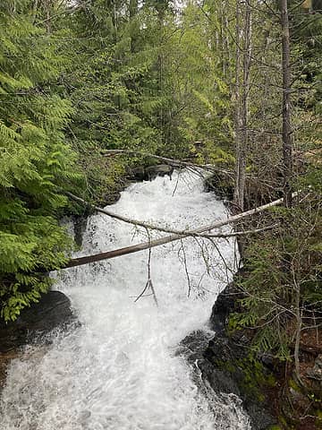 Tommy Creek. 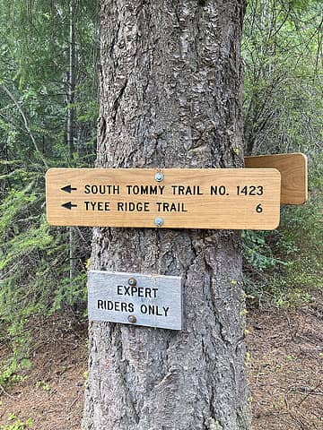 Start of South Tommy. 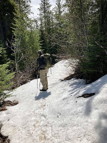 Around the 4000" level.
Cyclopath, RichP
Cyclopath, RichP |
| Back to top |
|
|
KascadeFlat
Member
Joined: 06 Jul 2020
Posts: 314 | TRs | Pics
Location: Eating peanut M&Ms under my blue tarp |
| Joey wrote: | | Speaking of closed roads, recently I stumbled over a DNR GIS layer that purports to show open/closed roads. I have no idea if this data is kept current. Maybe this will help people get some ideas on where to wander. Later this year you will be able to use this data to make your own custom offline map. Stay tuned...
Edit: I added a layer that shows DNR gates. If you zoom out that layer disappears. The zoom levels at which the data appears is defined on the GIS server - nothing I can do about that.
|
Whoa, this is really cool. Thanks for posting, Joey!
For a good time call: 1-800-SLD-ALDR.
Joey
For a good time call: 1-800-SLD-ALDR.
Joey
|
| Back to top |
|
|
|
|


