| Previous :: Next Topic |
| Author |
Message |
Bryan K
Shameless Peakbagger


Joined: 29 Sep 2005
Posts: 5129 | TRs | Pics
Location: Alaska |
|
Bryan K
Shameless Peakbagger
|
 Wed Dec 20, 2006 6:50 pm |
|
|
Does anyone have a route that they could post for this snowshoe trail. I thought someone had posted a pic of their route from their GPS but I can't find it.
|
| Back to top |
  
|
|
Elvis
Shuffl'n

Joined: 09 Jun 2004
Posts: 1804 | TRs | Pics
Location: del Boca Vista |
|
Elvis
Shuffl'n
|
Wed Dec 20, 2006 8:55 pm |
|
|
I'm pretty sure you are recalling the trip report from JimK last winter.
I'll PM you.
~E
"Ill habits gather unseen degrees, as brooks make rivers, rivers run to seas." ~John Dryden
My Trip List
"Ill habits gather unseen degrees, as brooks make rivers, rivers run to seas." ~John Dryden
My Trip List
|
| Back to top |
|
|
moosefish
I am the fish

Joined: 02 Jul 2004
Posts: 1209 | TRs | Pics
Location: monkey herder |
|
moosefish
I am the fish
|
Wed Dec 20, 2006 9:12 pm |
|
|
In spite of losing the trail after the metal power lines it's really pretty easy to follow the diamonds on the trees all the way to Nordic Pass. From Nordic Pass it's just a romp up the ridge to Mt. Catherine. It seemed like there was a trail on the south side of the ridge, but that might have been the tracks that were already there...
|
| Back to top |
|
|
JimK
Member

Joined: 07 Feb 2002
Posts: 5606 | TRs | Pics
Location: Ballard |
|
JimK
Member
|
Wed Dec 20, 2006 10:15 pm |
|
|
Ask and ye shall receive.
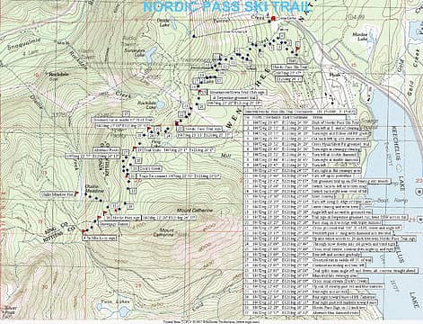 GPS map of the Nordic Pass Trail near Snoqualmie Pass.
|
| Back to top |
|
|
JimK
Member
Joined: 07 Feb 2002
Posts: 5606 | TRs | Pics
Location: Ballard |
|
JimK
Member
|
Wed Dec 20, 2006 10:21 pm |
|
|
Moosefish, in case you did not know, the Nordic Pass trail continues on down to Windy Pass. There are diamonds all the way to the road. It drops quite steeply beyond Nordic Pass.
|
| Back to top |
|
|
moosefish
I am the fish
Joined: 02 Jul 2004
Posts: 1209 | TRs | Pics
Location: monkey herder |
|
moosefish
I am the fish
|
Wed Dec 20, 2006 10:28 pm |
|
|
I figured it must continue, but we didn't follow beyond the snow gauge. There were snowshoe tracks coming up from that side. How high can you drive toward Windy Pass at this time of year?
|
| Back to top |
|
|
Malachai Constant
Member

Joined: 13 Jan 2002
Posts: 16107 | TRs | Pics
Location: Back Again Like A Bad Penny |
It continues to the hut in Olahlee Meadows and continues down the common corridor then down to the Iron Horse.
"You do not laugh when you look at the mountains, or when you look at the sea." Lafcadio Hearn
"You do not laugh when you look at the mountains, or when you look at the sea." Lafcadio Hearn
|
| Back to top |
|
|
dicey
custom title

Joined: 11 May 2004
Posts: 2869 | TRs | Pics
Location: giving cornices a wider berth |
|
dicey
custom title
|
Wed Dec 20, 2006 11:29 pm |
|
|
| moosefish wrote: | | I figured it must continue, but we didn't follow beyond the snow gauge. There were snowshoe tracks coming up from that side. How high can you drive toward Windy Pass at this time of year? |
About as far as Hyak
|
| Back to top |
|
|
dicey
custom title
Joined: 11 May 2004
Posts: 2869 | TRs | Pics
Location: giving cornices a wider berth |
|
dicey
custom title
|
Wed Dec 20, 2006 11:33 pm |
|
|
| JimK wrote: | | It drops quite steeply beyond Nordic Pass. |
 And this was the part that made skinning all the way there worth it!
  Olallie Meadows was nice too, and great views. Olallie Meadows was nice too, and great views.
|
| Back to top |
|
|
Magellan
Brutally Handsome

Joined: 26 Jul 2006
Posts: 13116 | TRs | Pics
Location: Inexorable descent |
|
Magellan
Brutally Handsome
|
Wed Dec 20, 2006 11:47 pm |
|
|
What kind of hut are we talking about? Open to the public? Overnight?
|
| Back to top |
|
|
JimK
Member
Joined: 07 Feb 2002
Posts: 5606 | TRs | Pics
Location: Ballard |
|
JimK
Member
|
Thu Dec 21, 2006 12:26 am |
|
|
Warming hut with fireplace for those who purchase groomed trail passes.
|
| Back to top |
|
|
daugman
Member

Joined: 26 Feb 2017
Posts: 22 | TRs | Pics
Location: Bellevue |
|
daugman
Member
|
Sat Jul 23, 2022 11:46 am |
|
|
Here's my summer route, that only follows the summer trail; parts of it vary slightly from the blue diamond winter route.Caltop map
 Elvis Elvis
Elvis |
| Back to top |
|
|
|
|


