| Previous :: Next Topic |
| Author |
Message |
Gimpilator
infinity/21M


Joined: 12 Oct 2006
Posts: 1684 | TRs | Pics
Location: Edmonds, WA |
The following 3 part report is a collection of impressions, photos and video from a month long trip starting in the beginning of 2017. The decision was made to climb Cotopaxi and Chimborazo in Ecuador. There was only one problem with that plan. Cotopaxi erupted recently and now the whole area is closed to climbing.  I suggested the Guatemalan volcanoes as an alternative. Around the core Guatemalan part of the trip, John Stolk proposed he and I go to Mexico prior, while Greg Slayden offered to finish the trip with me in Costa Rica. Note that Greg Slayden was not present for the Mexico leg and John Stolk went home after Guatemala.
The list of what we did including some distinctions:
Part 1 - MEXICO
Volcán La Malinche - 14,501' (38th highest in North America)
Cofre de Perote - 13,780'
Pico de Orizaba - 18,491' (country highpoint, 3rd highest in North America, 7th most prominent on earth)
Volcán Iztaccíhuatl - 17,126' (14th highest in North America, previously my biggest failed attempt)
Pico de Aguila 15,157
Nevado de Toluca - 15,354' (28th highest in North America)
Cerro de Ombugo - 14,173' (a lava dome similar to the one inside Saint Helens)
Pico de Humboldt - 14,698' (a previously unlisted/unknown 14er)
Nevado de Colima - 13,976' (sub peak Volcán de Colima multiple eruptions)
Cerro Tancitaro - 12,598'
Part 2 - GUATEMALA
Volcán Pacaya - 8373' (active magma and lava bombs visible)
Volcán Tajumulco - 13,845' (country highpoint, 24th most prominent peak on earth)
Volcán Concepción 13,287
Volcán Tacaná - 13,343' (2nd highest in Central America)
Cerro Chemal "La Torre" - 12,559'
Cerro Chemal "Cerro los Cuervos" - 12,589'
Montañas Peña Blanca - 11,549'
Volcán Santa María - 12,375' (sub peak Santiaguito eruption)
Volcán Atitlán - 11,604'
Volcán Acatenango - 13,041' (sub peak Volcán de Fuego eruption)
Part 3 - COSTA RICA
Volcán Poás - 8871'
Volcán Barva - 9534' (the most intense bushwhack Greg and I have ever done)
Volcán Irazú - 11,260'
Cerro Chirripó - 12,530' (country highpoint, 36th most prominent on earth)
Cerro Piramide - 12,490' (2nd highest in Costa Rica)
Cerro Terbi - 12,352'
Cerro Buenavista - 11,453'
January 7 - Volcán La Malinche - 14,501'
John and I started with Malinche which is a very nice acclimatization peak. We stayed for several days at the cabins near the trailhead before attempting the summit. The park among the cabins can be a bit wild on the weekend. Its the first time Ive heard karaoke amplified in Spanish. I suggested the Guatemalan volcanoes as an alternative. Around the core Guatemalan part of the trip, John Stolk proposed he and I go to Mexico prior, while Greg Slayden offered to finish the trip with me in Costa Rica. Note that Greg Slayden was not present for the Mexico leg and John Stolk went home after Guatemala.
The list of what we did including some distinctions:
Part 1 - MEXICO
Volcán La Malinche - 14,501' (38th highest in North America)
Cofre de Perote - 13,780'
Pico de Orizaba - 18,491' (country highpoint, 3rd highest in North America, 7th most prominent on earth)
Volcán Iztaccíhuatl - 17,126' (14th highest in North America, previously my biggest failed attempt)
Pico de Aguila 15,157
Nevado de Toluca - 15,354' (28th highest in North America)
Cerro de Ombugo - 14,173' (a lava dome similar to the one inside Saint Helens)
Pico de Humboldt - 14,698' (a previously unlisted/unknown 14er)
Nevado de Colima - 13,976' (sub peak Volcán de Colima multiple eruptions)
Cerro Tancitaro - 12,598'
Part 2 - GUATEMALA
Volcán Pacaya - 8373' (active magma and lava bombs visible)
Volcán Tajumulco - 13,845' (country highpoint, 24th most prominent peak on earth)
Volcán Concepción 13,287
Volcán Tacaná - 13,343' (2nd highest in Central America)
Cerro Chemal "La Torre" - 12,559'
Cerro Chemal "Cerro los Cuervos" - 12,589'
Montañas Peña Blanca - 11,549'
Volcán Santa María - 12,375' (sub peak Santiaguito eruption)
Volcán Atitlán - 11,604'
Volcán Acatenango - 13,041' (sub peak Volcán de Fuego eruption)
Part 3 - COSTA RICA
Volcán Poás - 8871'
Volcán Barva - 9534' (the most intense bushwhack Greg and I have ever done)
Volcán Irazú - 11,260'
Cerro Chirripó - 12,530' (country highpoint, 36th most prominent on earth)
Cerro Piramide - 12,490' (2nd highest in Costa Rica)
Cerro Terbi - 12,352'
Cerro Buenavista - 11,453'
January 7 - Volcán La Malinche - 14,501'
John and I started with Malinche which is a very nice acclimatization peak. We stayed for several days at the cabins near the trailhead before attempting the summit. The park among the cabins can be a bit wild on the weekend. Its the first time Ive heard karaoke amplified in Spanish.
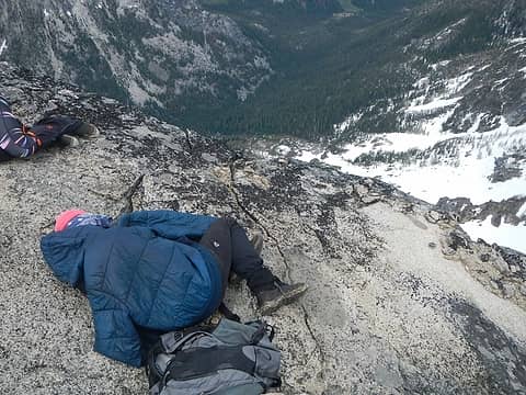
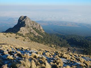 Cerro Tlachichihuatzi below 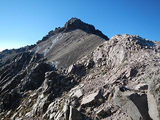 John on the summit 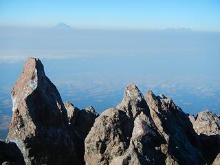 Popocatépetl and Iztaccíhuatl 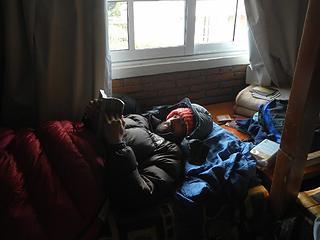 in the Malinche cabins 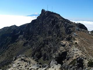 the south peak with Orizaba behind  stairway 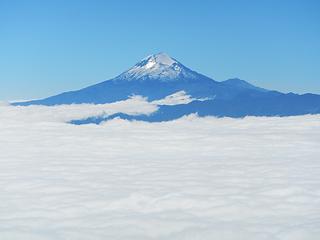 Orizaba viewed from the south peak 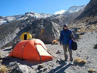 camping 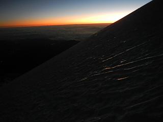 Jampa Glacier 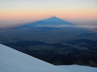 mountain shadow 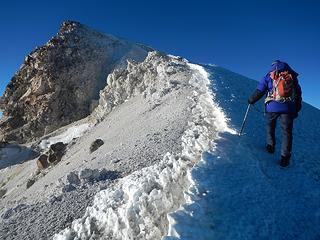 crater rim 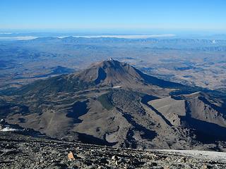 Sierra Negra below 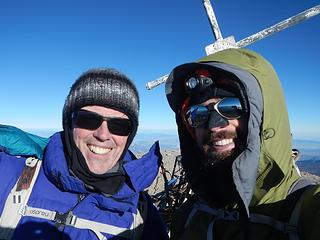 Stoked! 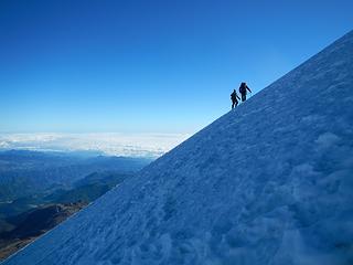 18,000 feet 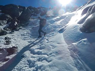 the canaleta 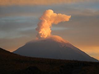 Popocatépetl 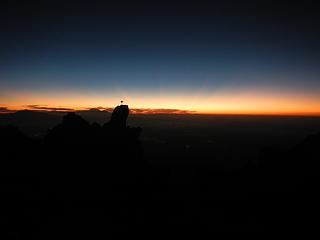 predawn 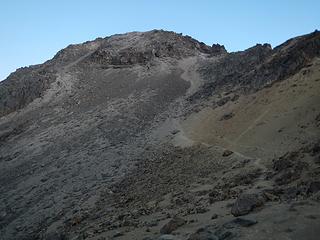 "the knees" above 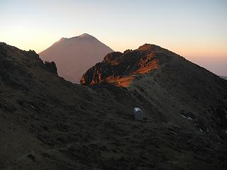 Grupo de los Cien 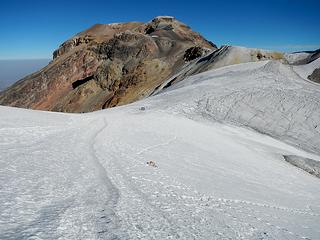 on the first glacier 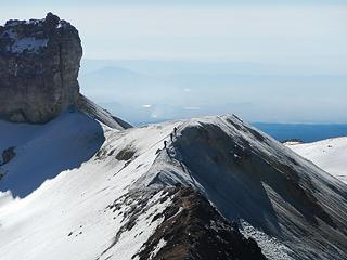 3 climbers 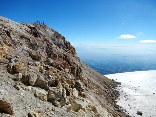 people calling it good at the south summit 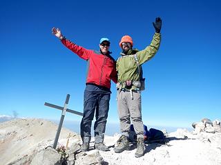 north summit 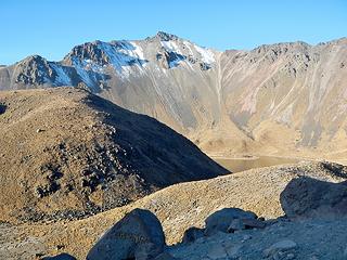 first view of Toluca main peak 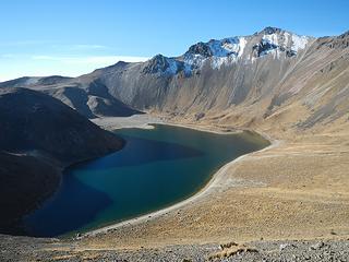 the larger of two lakes 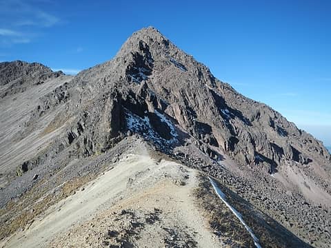 nearing Aguila 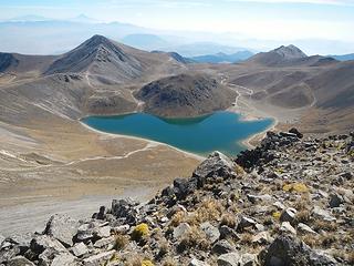 Humboldt and Ombugo below 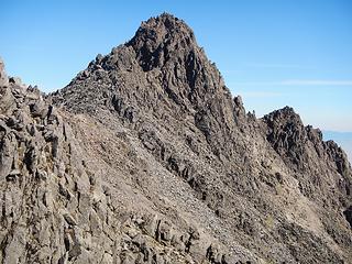 looking back at Aguila 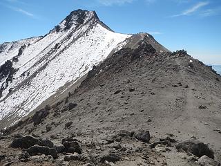 Fraile the main peak 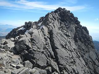 last bit 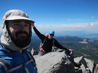 Toluca main summit 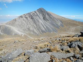 Humboldt seen from Ombugo 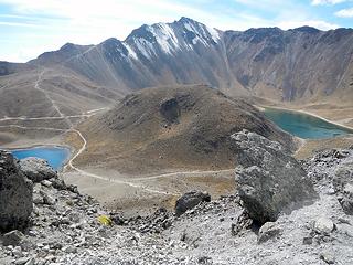 looking back at the main peak and Ombugo 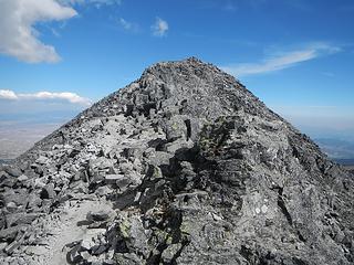 Humbolt, the secret 14er 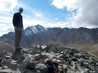 John on the summit of Humboldt 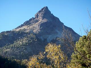 false summit seen from approach road 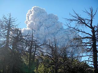 Apocalypse 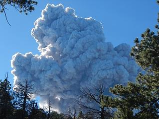 Run for your life! 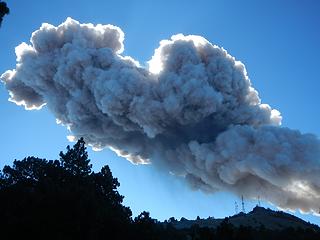 the main plume passing to the northeast fortunately 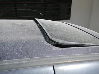 ash on a car near the building we took shelter at 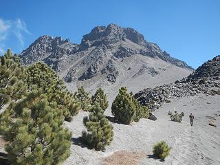 Nevado de Colima 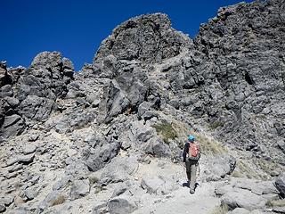 on the south side  in the couloir 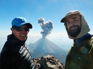 eruption #2 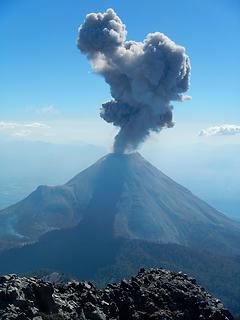 pretty sweet 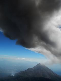 here it comes again 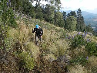 the start of the tussocks 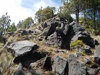 near the summit 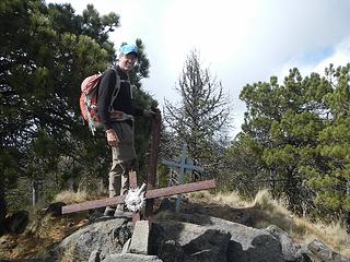 summit
|
| Back to top |
  
|
|
Magellan
Brutally Handsome

Joined: 26 Jul 2006
Posts: 13116 | TRs | Pics
Location: Inexorable descent |
|
Magellan
Brutally Handsome
|
 Wed Feb 08, 2017 1:41 pm |
|
|
Wonderful stories! 
|
| Back to top |
|
|
Jim Dockery
Member

Joined: 12 Sep 2007
Posts: 3092 | TRs | Pics
Location: Lake Stevens |
Great TR and congrats on so many successful summits!
|
| Back to top |
|
|
Fletcher
Member

Joined: 29 Jul 2009
Posts: 1870 | TRs | Pics
Location: kirkland |
|
Fletcher
Member
|
Wed Feb 08, 2017 2:02 pm |
|
|
Dude.. this is amazing. Well done.
|
| Back to top |
|
|
RichP
Member

Joined: 13 Jul 2006
Posts: 5634 | TRs | Pics
Location: here |
|
RichP
Member
|
Wed Feb 08, 2017 3:18 pm |
|
|
Excelente, amigo.
|
| Back to top |
|
|
Brushbuffalo
Member

Joined: 17 Sep 2015
Posts: 1887 | TRs | Pics
Location: there earlier, here now, somewhere later... Bellingham in between |
Wow, another one of your adventures. How exciting to experience at rather close range one of Colima's eruption episodes during its ongoing activity. The first one that startled and dusted you and John looks like an energetic Strombolian-type eruption or a relatively mild vulcanian type. The one you linked a video to looks to be a classic vulcanian-style. Eruption styles grade into one another, with Strombolian ( moderate eruption plume with airborne "blebs" of moderately-viscous lava) grading up from Hawaiian (mostly basaltic lava flows) to vulcanian (more explosive ejection of blocks, cinder, ash, and dust into the air). There are other styles. Interested? Try here
quote="Gimpilator"]What are the chances of two eruptions in one day? [/quote]
With Colima right now, the chances are pretty good.
| Gimpilator wrote: | | started with Malinche which is a very nice acclimatization peak. We stayed for several days at the cabins near the trailhead before attempting the summit. The park among the cabins can be a bit wild on the weekend |
We had a group of young ones partying loudly right outside our cabin there, too.
Sleep's over-rated. 
Passing rocks and trees like they were standing still
Passing rocks and trees like they were standing still
|
| Back to top |
|
|
contour5
Member

Joined: 16 Jul 2003
Posts: 2963 | TRs | Pics
|
|
contour5
Member
|
Wed Feb 08, 2017 7:47 pm |
|
|
Great stuff! You really managed to hit a lot of high points!
|
| Back to top |
|
|
awilsondc
Member

Joined: 03 Apr 2016
Posts: 1324 | TRs | Pics
|
|
| Back to top |
|
|
John Morrow
Member

Joined: 03 Apr 2007
Posts: 1526 | TRs | Pics
Location: Roslyn |
Wow, so amazing, every moment of it!
Tell me, what is it you plan to do with your one wild and precious life?-Mary Oliver
A nation that continues year after year to spend more money on military defense than on programs of social uplift is approaching spiritual doom.
― MLK Jr.
Tell me, what is it you plan to do with your one wild and precious life?-Mary Oliver
A nation that continues year after year to spend more money on military defense than on programs of social uplift is approaching spiritual doom.
― MLK Jr.
|
| Back to top |
|
|
mike
Member
Joined: 09 Jul 2004
Posts: 6397 | TRs | Pics
Location: SJIsl |
|
mike
Member
|
Wed Feb 08, 2017 11:11 pm |
|
|
| Gimpilator wrote: | Sierra Negra below |
interesting to see this photo. Not what it used to be. My wife and I visited many years ago. No roads, no telescopes. We hired horses and arriero guide in San Juan because there was no water and we had to pack it all in. We basically followed trails approximately where the road now goes. There are caves next to the lava flow in the pass between the peaks but we didn't camp there as there was garbage all over and we wanted to be more discrete so we went a ways away. Next day we climbed Sierra La Negra to acclimatize and the following day went up to the refugio and a little farther but bagged it. 4000+' of steep scree and blowing dirt. Explored around until the water ran out and walked out.
|
| Back to top |
|
|
FiresideChats
Member

Joined: 20 Jan 2014
Posts: 365 | TRs | Pics
Location: San Juan Islands |
Lots of fun to read. Dodging eruptions puts you solidly in the muy loco category.
|
| Back to top |
|
|
Michael Lewis
Taking a nap
Joined: 27 Apr 2009
Posts: 629 | TRs | Pics
Location: Lynnwood, WA (for now) |
This is one of the coolest trip reports I've ever read!
|
| Back to top |
|
|
Nancyann
Member
Joined: 28 Jul 2013
Posts: 2318 | TRs | Pics
Location: Sultan Basin |
|
Nancyann
Member
|
Thu Feb 09, 2017 12:45 pm |
|
|
Michael Lewis wrote: "This is one of the coolest trip reports I've ever read."
 Thanks for taking the time to write this up, Gimpilator, what a memorable adventure, and glad your beard didn't get singed, or worse.
|
| Back to top |
|
|
Bryan K
Shameless Peakbagger

Joined: 29 Sep 2005
Posts: 5129 | TRs | Pics
Location: Alaska |
|
Bryan K
Shameless Peakbagger
|
Fri Feb 10, 2017 10:25 pm |
|
|
First of all, digging the beard buddy! Second, if we weren't already close friends, I'd think you were the most awesome guy alive, instead I'm just glad you didn't get burned alive by ash fall  Great stuff buddy, keep it up! Can't wait to peruse part 2 sometime tomorrow.
|
| Back to top |
|
|
Gimpilator
infinity/21M
Joined: 12 Oct 2006
Posts: 1684 | TRs | Pics
Location: Edmonds, WA |
I'd like to apologize to everyone who took the time to comment on this series of trip reports. Basically I posted this report and then jumped right into research for the next trip. Very sorry for being self-absorbed and inconsiderate. I'm going to go back now and reply to some comments even though it's late in the game.
| Brushbuffalo wrote: | | Eruption styles grade into one another, with Strombolian ( moderate eruption plume with airborne "blebs" of moderately-viscous lava) grading up from Hawaiian (mostly basaltic lava flows) to vulcanian (more explosive ejection of blocks, cinder, ash, and dust into the air). |
Doug, thanks for the details. I figured you would know. 
| mike wrote: | | Gimpilator wrote: | Sierra Negra below |
interesting to see this photo. Not what it used to be. My wife and I visited many years ago. No roads, no telescopes. We hired horses and arriero guide in San Juan because there was no water and we had to pack it all in. We basically followed trails approximately where the road now goes. There are caves next to the lava flow in the pass between the peaks but we didn't camp there as there was garbage all over and we wanted to be more discrete so we went a ways away. Next day we climbed Sierra La Negra to acclimatize and the following day went up to the refugio and a little farther but bagged it. 4000+' of steep scree and blowing dirt. Explored around until the water ran out and walked out. |
That's an amazing story. I wish it was still possible to get the peak in that fashion. I had no idea there were caves up there. Fortunately it's still possible to go up there for the time being, but the new regulations make it a hassle.
| Bryan K wrote: | | First of all, digging the beard buddy! Second, if we weren't already close friends, I'd think you were the most awesome guy alive, instead I'm just glad you didn't get burned alive by ash fall |
Thanks! I'm really looking forward to hiking together again soon. Seriously excited about that!
Thanks everyone else. This trip was a wonderful experience for me and it's cool that I can share it with the local hiking community and know that future generations might be able to use it for beta.
|
| Back to top |
|
|
|
|
You cannot post new topics in this forum
You cannot reply to topics in this forum
You cannot edit your posts in this forum
You cannot delete your posts in this forum
You cannot vote in polls in this forum
|
Disclosure: As an Amazon Associate NWHikers.net earns from qualifying purchases when you use our link(s). |


