| Previous :: Next Topic |
| Author |
Message |
Matt Lemke
High on the Outdoors


Joined: 15 Jul 2010
Posts: 2052 | TRs | Pics
Location: Grand Junction |
|
Matt Lemke
High on the Outdoors
|
 Wed Aug 30, 2017 3:31 pm |
|
|
Since the Wind Rivers trip Josh and I had planned after the eclipse didn't quite pan out due to car issues I was having, we drove back to WA, and I bought a 2015 Ford Transit 350 cargo van. I then had one more day before I had to drive back to Edmonton, so Josh and I agreed to do Clark and Luahna since neither of us had done those yet. Since I was helping my dad build their new deck Friday afternoon, I went to pick up Josh late in my new supersized van (which Elaine and I will be converting into our home over the next year or so) and we drove partway out towards Stevens Pass until we found a good place to crash. We both could easily sleep inside the van, with a ton of room to spare!
We planned to wake up at 5:30 but like always, that didn't happen. By 7am we started driving and didn't start hiking until around 8. Unfortunately the final 2 miles of the White River Road were closed! We briefly contemplated whether to do something else or not but agreed it was Clark and Luahna or bust at this point. So we parked and started walking up the road. After 30 minutes or so we reached the trailhead and made our first of a few time consuming mistakes of the day. We started hiking the trail on the west side of White River. We continued all the way until I noticed the trail curve sharply left away from White River and we consulted the map. Low and behold, we were on the wrong side of the river!!
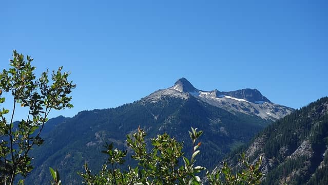 Mount David 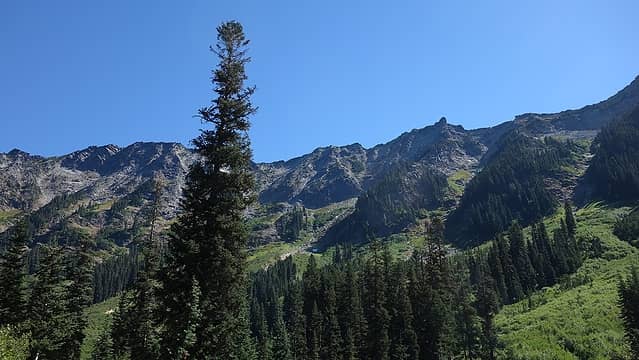 Hiking up Boulder Pass Trail 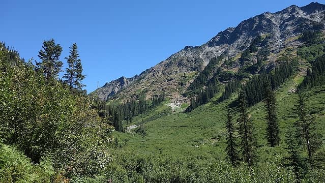 This would really suck without a trail 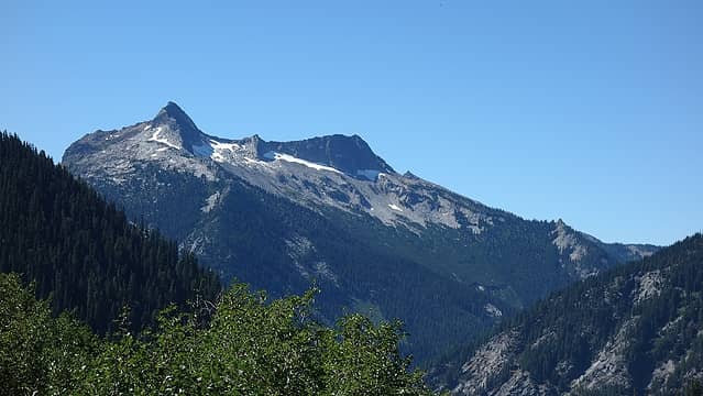 Mount David Again 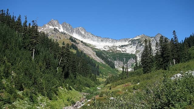 Entering the upper basin 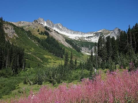 OMG These flowers made the perfect photo 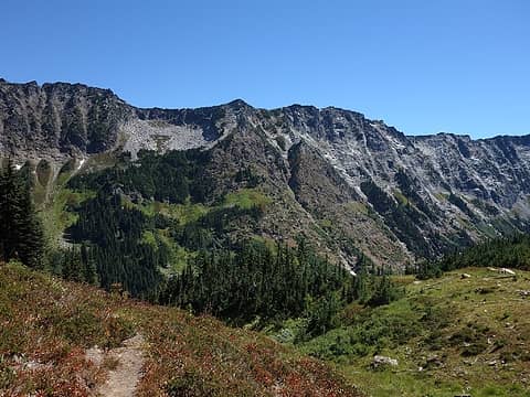 Hiking up the Shepherds Trail 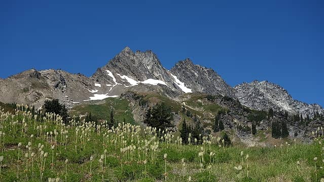 Ascending to the crossover ridge 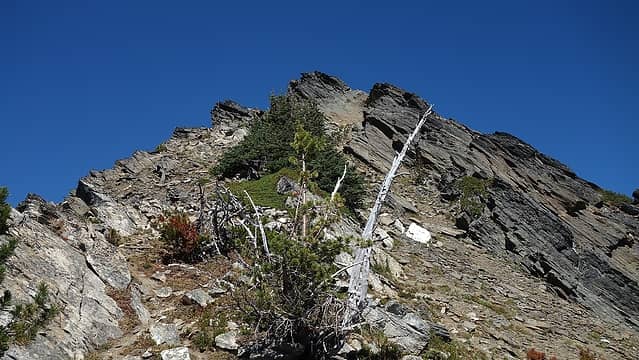 At the ridge 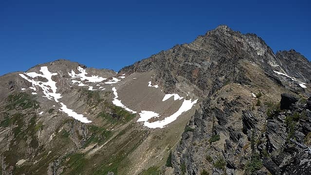 First views of the summit of Clark to the left 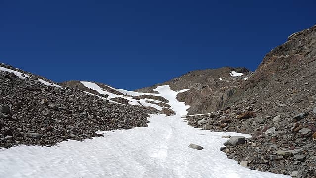 The snow finger we ascended 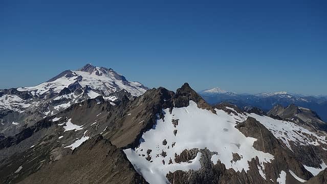 Luahna and Glacier Peak 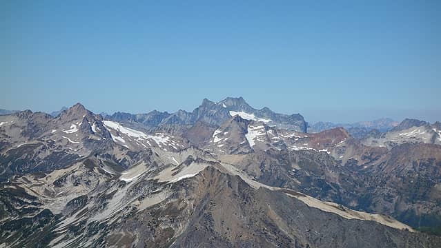 Fernow Group 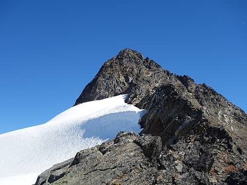 Looking back at Clark 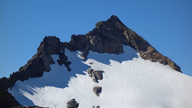 Luahna 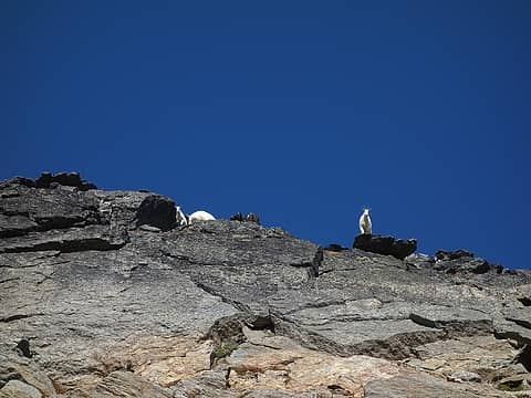 The goats! 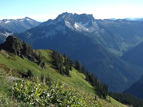 This stuff was slippery! 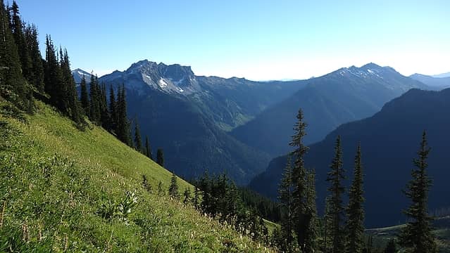 More slippery 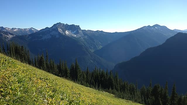 Slippery again... 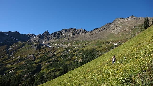 Josh giving up
|
| Back to top |
  
|
|
zephyr
aka friendly hiker

Joined: 21 Jun 2009
Posts: 3370 | TRs | Pics
Location: West Seattle |
|
zephyr
aka friendly hiker
|
Wed Aug 30, 2017 7:05 pm |
|
|
Looks like y'all had an awesome day up there. Great weather and sky. So many others have been getting smoke. Excellent report and photos. ~z
|
| Back to top |
|
|
ozzy
The hard way

Joined: 30 Jul 2015
Posts: 476 | TRs | Pics
Location: University place, wa |
|
ozzy
The hard way
|
Thu Aug 31, 2017 5:46 am |
|
|
Sick day trip dudes! Been wanting to step foot up there for a long time now, thanks for the good TR, cheers!
I dont know whats gonna happen, but I wanna have my kicks before the whole shithouse goes up in flames-Mr Mojo Risin
I dont know whats gonna happen, but I wanna have my kicks before the whole shithouse goes up in flames-Mr Mojo Risin
|
| Back to top |
|
|
ozzy
The hard way
Joined: 30 Jul 2015
Posts: 476 | TRs | Pics
Location: University place, wa |
|
ozzy
The hard way
|
Thu Aug 31, 2017 5:47 am |
|
|
Oh yeah whay was the time, distance, and elev. If you dont mind?!
I dont know whats gonna happen, but I wanna have my kicks before the whole shithouse goes up in flames-Mr Mojo Risin
I dont know whats gonna happen, but I wanna have my kicks before the whole shithouse goes up in flames-Mr Mojo Risin
|
| Back to top |
|
|
BBB
Member

Joined: 28 Oct 2011
Posts: 11 | TRs | Pics
|
|
BBB
Member
|
Thu Aug 31, 2017 8:12 am |
|
|
You guys had to get Ripped up going thru the bottom in the dark , got any pics of your shins ?
|
| Back to top |
|
|
Brushbuffalo
Member

Joined: 17 Sep 2015
Posts: 1887 | TRs | Pics
Location: there earlier, here now, somewhere later... Bellingham in between |
Ambitious plan, and you did it despite various obstacles. Good work!
| BBB wrote: | | You guys had to get Ripped up going thru the bottom in the dark , got any pics of your shins ? |
How about pictures of bites? That area has a reputation for very hungry black flies, and looks like you gave them lots of flesh to hit!
Passing rocks and trees like they were standing still
Passing rocks and trees like they were standing still
|
| Back to top |
|
|
Matt Lemke
High on the Outdoors
Joined: 15 Jul 2010
Posts: 2052 | TRs | Pics
Location: Grand Junction |
|
Matt Lemke
High on the Outdoors
|
Thu Aug 31, 2017 8:48 am |
|
|
Luckily there were no bugs. Unfortunately I didn't get any shin photos but I can assure the first layer of skin was completely gone!
I'll add a map to this TR today, but the RT distance I think was about 24 miles and elev gain about 7200 feet
|
| Back to top |
|
|
reststep
Member
Joined: 17 Dec 2001
Posts: 4757 | TRs | Pics
|
|
reststep
Member
|
Thu Aug 31, 2017 1:23 pm |
|
|
Thanks for the report and pictures.
No pictures of the van?
"The mountains are calling and I must go." - John Muir
"The mountains are calling and I must go." - John Muir
|
| Back to top |
|
|
Matt Lemke
High on the Outdoors
Joined: 15 Jul 2010
Posts: 2052 | TRs | Pics
Location: Grand Junction |
|
Matt Lemke
High on the Outdoors
|
Thu Aug 31, 2017 2:07 pm |
|
|
| reststep wrote: | | Thanks for the report and pictures.
No pictures of the van? |
I actually meant to include one but forgot haha. Here is the photo the sales woman took of me when I bought it!
Can't wait to start the conversion 
|
| Back to top |
|
|
Brushbuffalo
Member
Joined: 17 Sep 2015
Posts: 1887 | TRs | Pics
Location: there earlier, here now, somewhere later... Bellingham in between |
Cool, but if it's going to be home, where you going to put the training room? (Suggestion: just glue plastic holds all over the outside  )
Seriously, with no windows on left side, why not?
Or you could play soccer inside that massive cave! )
Seriously, with no windows on left side, why not?
Or you could play soccer inside that massive cave!
Passing rocks and trees like they were standing still
Passing rocks and trees like they were standing still
|
| Back to top |
|
|
Opus
Wannabe

Joined: 04 Mar 2006
Posts: 3700 | TRs | Pics
Location: The big rock candy mountain |
|
Opus
Wannabe
|
Fri Sep 01, 2017 4:13 pm |
|
|
Nice! Your first "navigation error" is actually quite helpful. I just finished along loop going in Indian Creek and returning White River and was wondering how hard it would be to cross straight over via either a ford or log in that exact spot. Now I know for a future trip!
Also a contractor is currently fixing the road. They said they'd be finished by the end of next week but it's up to the FS when the road reopens.
|
| Back to top |
|
|
Matt Lemke
High on the Outdoors
Joined: 15 Jul 2010
Posts: 2052 | TRs | Pics
Location: Grand Junction |
|
Matt Lemke
High on the Outdoors
|
Sat Sep 02, 2017 11:56 am |
|
|
| Brushbuffalo wrote: | | Cool, but if it's going to be home, where you going to put the training room? (Suggestion: just glue plastic holds all over the outside )
Seriously, with no windows on left side, why not?
Or you could play soccer inside that massive cave! |
OMG we should do that! haha that is awesome 
|
| Back to top |
|
|
|
|


