| Previous :: Next Topic |
| Author |
Message |
Ski
><((((°>


Joined: 28 May 2005
Posts: 12830 | TRs | Pics
Location: tacoma |
|
Ski
><((((°>
|
 Fri Sep 08, 2017 1:18 am |
|
|
Queets 59th Anniversary (reprise) 09-04-17 - 09-06-17
USGS 12040500 090417 @ 05:30 PDT 550 CFS
Central Park 090417 @ 08:30 PDT 65° F
Amanda Park 090417 @ 09:35 PDT 80° F
Left home at 7:10 am, arrived at trailhead 10:40 am. Weather clear warm sunny and fabulous the entire way.
Met nwhikers member sams_rapids at trailhead, who had driven up to say hello. His car and my truck made for no fewer than fifteen (15) vehicles at trailhead. There was one couple loading up gear in their car leaving as we were arriving.
No permits in box at trailhead kiosk (again - same as last month.)
We walked down out onto the gravel bar and talked for a bit. Ford about 50 yards downstream from the mouth of the Sams was barely knee deep. I crossed, and sams_rapids waved goodbye, on his way down to enjoy the beach at Kalaloch.
Met Eric from Quilcene just shy of Old Joe Creek (less than half a mile up the trail) and we talked for a bit. He had come up to do a little fishing and was on his way out. He asked about a couple of destinations in the area. (Eric if you're reading this contact me via PM and I'll send you links to the reports.)
As Eric and I were talking, another couple passed us on their way out.
Ran into Ernie at the west end of Andrews Field with his party. They had been up for a few days doing a little work on the trail and were on their way out. He said they'd cut a bit of a bypass around the section that had washed out between (approx.) mile 3.0 and (approx.) mile 4.0. Ernie said he'd be back up next week (presumably in the same place as usual.)
The little footbridge just past Andrews Field (that Don Gores built, as I recall) has a loose plank. A couple big nails and a hammer (or big rock) would quickly remedy the problem. Best to fix it before somebody (or some critter) gets tripped up on it.
Met another couple just past Andrews Field on their way out. They said there were a lot of people camped upstream. As we were talking another couple passed by us on their way out.
A little farther on met another party, Barry and son Conner, who had been up to do a little fishing. Barry said he'd tied into a steelhead and a chinook up above. As we were talking a party of four passed by us on their way out.
The water in Coal Creek was pretty much dried up. There was a trickle down there somewhere under the rocks, but you'd have to stop and hold your breath to hear it. I cannot recall when Coal Creek didnt have running water in it.
Just above Coal Creek met two young men packing rods. They said they'd just come up for the weekend and they were on their way out.
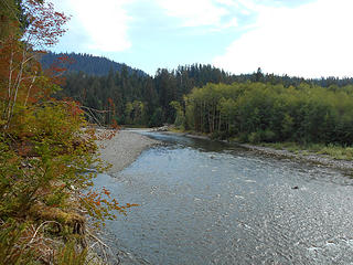 Queets River Trail (approx) mile 3.0 090417 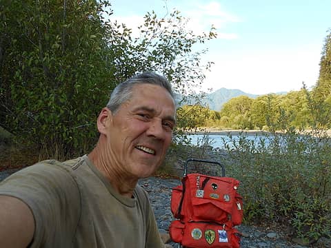 bk below Tshletshy 090417 01 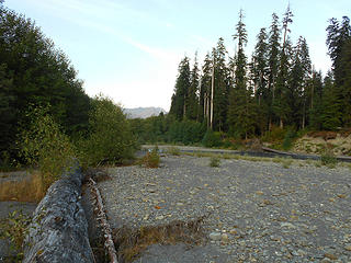 Queets River below Tshletshy 090417 01 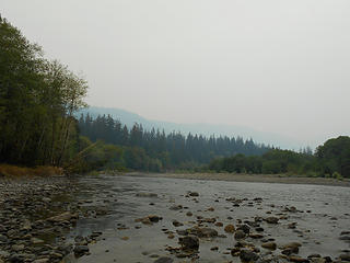 Queets River below Tshletshy 090517 0900 PDT 01 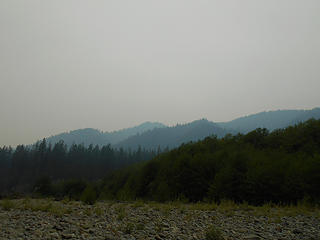 Queets River below Tshletshy 090517 0900 PDT 02 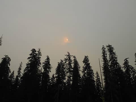 Queets River below Tshletshy 090517 1115 PDT 03  Queets River below Tshletshy 090517 1355 PDT 04 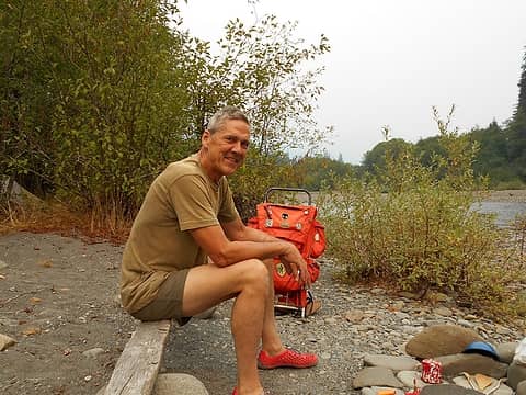 bk below Tshletshy 090517 01 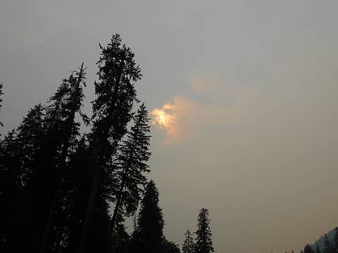 Queets River below Tshletshy 090517 1600 PDT 05 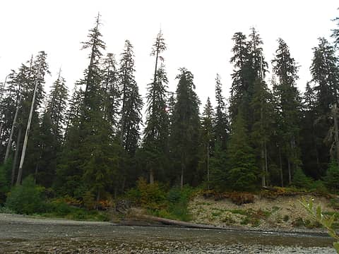 Queets River below Tshletshy 090617 0900 PDT 01 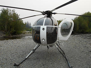 Hughes 500 at Tshletshy 090617 1040 PDT 01
"I shall wear white flannel trousers, and walk upon the beach.
I have heard the mermaids singing, each to each."
"I shall wear white flannel trousers, and walk upon the beach.
I have heard the mermaids singing, each to each."
|
| Back to top |
  
|
|
Sallie4jo
Member

Joined: 24 Jun 2009
Posts: 220 | TRs | Pics
Location: Seattle |
Love your write up...time for me to go back out there. Been close to 30 years..so it's time. Way more people by your account! Happy 59 then.
I choose to live in a landscape of hope.
Terry Tempest Williams
I choose to live in a landscape of hope.
Terry Tempest Williams
|
| Back to top |
|
|
meck
Member
Joined: 31 Dec 2010
Posts: 920 | TRs | Pics
|
|
meck
Member
|
Fri Sep 08, 2017 5:23 pm |
|
|
Really enjoyed your descriptions of this area Ski! This is getting much higher on my list of places to to go visit in the ONP. You mentioned only knee deep fording, in a typical late summer is it more mid-thigh to waist deep (knowing that it can vary a lot during the day and temp)?
*Just say NO to Rent-Seeking, don't give up the concept of "ownership"*
*Just say NO to Rent-Seeking, don't give up the concept of "ownership"*
|
| Back to top |
|
|
AlpineRose
Member
Joined: 08 May 2012
Posts: 1953 | TRs | Pics
|
Mmmm. Your meals look really tasty, prompting me to ask - do you eat when you hike, or hike when you eat? Rad coffee cup, too.
|
| Back to top |
|
|
Ski
><((((°>
Joined: 28 May 2005
Posts: 12830 | TRs | Pics
Location: tacoma |
|
Ski
><((((°>
|
Fri Sep 08, 2017 8:19 pm |
|
|
| meck wrote: | | You mentioned only knee deep fording, in a typical late summer is it more mid-thigh to waist deep (knowing that it can vary a lot during the day and temp)? |
Well, the river's running pretty low right now - 550 CFS the other day when I went in, and it's flattened out at 422 CFS for the last three days. (USGS gaging station site)
You won't see significant variations in streamflow this late in the season when the water is as low as it is right now (unless a big rain comes in off the coast) - most of the ice and snowpack that's going to melt has already melted.
Generally the daily fluctuations in streamflow occur earlier in the season - June and July - when you'll see it jump up a little after a really warm day.
Another thing that happened is that the streambed at that particular point has changed somewhat during the last few years, making the ford at that location more shallow. For the last 20+ years I've been fording about 50 yards upstream from the mouth of the Sams (just above the first big snag that's hanging out over the bank) even though the water there was a bit deeper, because it runs slower up there at the bottom end of that big pool.
There hasn't been anything "typical" for over a decade; the river's been running at record lows for quite a while because of lower snowpacks and receding glaciers up above.
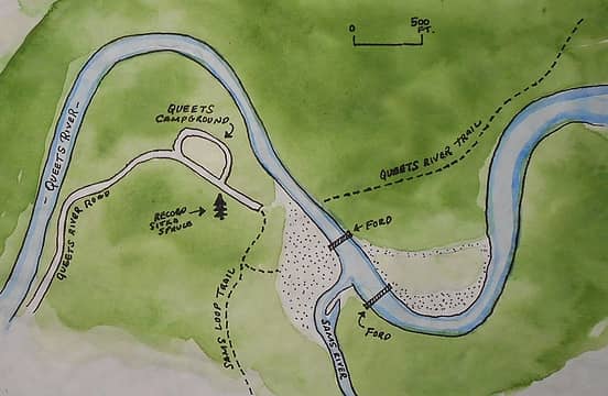
Here's a graphic for you. The lower ford location marked is the one I used this season - it was barely knee-deep on Monday.
The upper ford location marked is the one I was using for the last couple decades. The water depth is considerably deeper, but the water runs pretty slow there because it's at the bottom end of a big pool. Again, look for a big snag hanging out over the bank there and cross just upstream from it.
For now, however, use the easier, shallower, lower ford just below the mouth of the Sams River.
When you get to the end of the road, start walking down the Sams Loop Trail a little ways, and you'll find a trail branching off to the left, which will drop you down onto the gravel bar.
Walk across the gravel bar and ford.
The Queets River Trail begins on the other side of the river.
(Disclaimer: Locations of some items may not be entirely accurate. Location of stream channel is based on 2017 Google Earth image. Stream channel location, fording locations, streambed level, and gravel bars change from year to year.)
 ===================================================================================================================== | sams_rapids wrote: | | After seeing you off, I spent a couple hours on the first beach bluff watching grey whales. They were just past the breakers. Maybe 4 or 5. Think they were having lunch. Some one said whales were visible all the way to the main campground. |
I spent an hour or so one day watching a mother whale and her baby lolling about in the surf down at South Beach several years ago while I was doing some trail work, but never a group of four or five.
Just an FYI if you're headed that direction this week. 
"I shall wear white flannel trousers, and walk upon the beach.
I have heard the mermaids singing, each to each."
"I shall wear white flannel trousers, and walk upon the beach.
I have heard the mermaids singing, each to each."
|
| Back to top |
|
|
meck
Member
Joined: 31 Dec 2010
Posts: 920 | TRs | Pics
|
|
meck
Member
|
Sat Sep 09, 2017 2:29 pm |
|
|
Thanks Ski! Aside from trying to travel through feet of powder snow, and being stuck in torrential rains w/o shelter, the only other thing that really concerns me when traveling in the Olys is having to ford rivers! Its nice to hear that it quite passable this time of year.
Do you think it is still possible to follow the trail to its end at Pelton Creek Camp?
*Just say NO to Rent-Seeking, don't give up the concept of "ownership"*
*Just say NO to Rent-Seeking, don't give up the concept of "ownership"*
|
| Back to top |
|
|
Ski
><((((°>
Joined: 28 May 2005
Posts: 12830 | TRs | Pics
Location: tacoma |
|
Ski
><((((°>
|
Sat Sep 09, 2017 3:37 pm |
|
|
| meck wrote: | | Do you think it is still possible to follow the trail to its end at Pelton Creek Camp? |
 I suppose the answer to that question depends upon who you're asking.
If you read through the posts in my last trip report on the Queets you'll find a post by nwhikers member tomlike (here) in which he said they had difficulty finding the trail between Pelton and Paradise.
A year ago Gary Patton sent me an email and some photos that I posted (here) of the burn area just above Bob Creek. He didn't mention having any difficulty finding the trail. I first met Gary up there in 1989. He and his family have been hiking the Queets longer than I have.
Ernie went up there in the fall of 2015 with a photographer so that some photo images could be captured of the burned area. That was right after the fire was completely out. Ernie certainly didn't have any trouble finding the trail, but like Gary's family, Ernie's probably been hiking that trail longer than I have.
Last summer nwhikers member javman and Sam (an acquaintance of mine I first met on the Queets in 1992) both went up above the burn area, and I don't recall either of them reporting that they had any difficulty finding the trail up above Bob Creek. (See javman's photos here.) (Sam's photo is a couple of posts below.) But again, both of them are fairly familiar with the area and are quite adept at off-trail cross-country travel.
Coincidentally I just got an email from Sam saying he was thinking about venturing up at least to Kilkelly:
I suppose the answer to that question depends upon who you're asking.
If you read through the posts in my last trip report on the Queets you'll find a post by nwhikers member tomlike (here) in which he said they had difficulty finding the trail between Pelton and Paradise.
A year ago Gary Patton sent me an email and some photos that I posted (here) of the burn area just above Bob Creek. He didn't mention having any difficulty finding the trail. I first met Gary up there in 1989. He and his family have been hiking the Queets longer than I have.
Ernie went up there in the fall of 2015 with a photographer so that some photo images could be captured of the burned area. That was right after the fire was completely out. Ernie certainly didn't have any trouble finding the trail, but like Gary's family, Ernie's probably been hiking that trail longer than I have.
Last summer nwhikers member javman and Sam (an acquaintance of mine I first met on the Queets in 1992) both went up above the burn area, and I don't recall either of them reporting that they had any difficulty finding the trail up above Bob Creek. (See javman's photos here.) (Sam's photo is a couple of posts below.) But again, both of them are fairly familiar with the area and are quite adept at off-trail cross-country travel.
Coincidentally I just got an email from Sam saying he was thinking about venturing up at least to Kilkelly:
| Sam, in an email on 09/08/17 @ 11:18 PDT wrote: | | yes, I was planning on climbing up to Hoh peak from s. fork hoh, but on tuesday the haze was so thick the peak was just a silhouette, so no point going up for views.
Want to get back to Queets for another look above Kilkelly rapids this year. |
When I met Ernie on the trail Monday, I mentioned to him that I had seen a couple reports of people having difficulty finding the trail above Bob Creek, to which he responded "Well, they just don't know where the goddam trail is!"
Which pretty much sums it up: if you know where the trail is, you probably won't have much trouble finding it. If you don't know where the trail is, you might have to hunt for it.
I would highly recommend the USGS 7.5 topographical maps for the "Kloochman Rock", "Bob Creek", and "Kimta Peak" quandrangles if you're thinking of venturing up there.
"I shall wear white flannel trousers, and walk upon the beach.
I have heard the mermaids singing, each to each."
"I shall wear white flannel trousers, and walk upon the beach.
I have heard the mermaids singing, each to each."
|
| Back to top |
|
|
Ski
><((((°>
Joined: 28 May 2005
Posts: 12830 | TRs | Pics
Location: tacoma |
|
Ski
><((((°>
|
Sun Sep 10, 2017 10:20 am |
|
|
meck:
| Sam, in an email on 09/10/17 @ 10:05 PDT wrote: | | As far as the trail above bob, I recall dropping down into some alder flats at the first point you can see the fire zone on the upper benches, maybe a half mile or mile above bob creek. But for the most part I kept to the river, fording to best side once the fire reached the river. It's a tangle of weeds, downed limbs, and snags. Wouldn't waste time trying to navigate it. |
addendum 09/10/17 11:10 PDT:
doing some back-and-forth here via email with Sam right now. considering possibility of going up again later in the month - higher up. looking for a good weather window, which isn't in the immediate forecast. bk.
addendum 09/10/17 18:45 PDT:
After re-reading all that blather I just posted above, I suppose I should point out that the "trail" has always been difficult to find once you get up about 8 or 9 miles - the trail meanders through several meadows, and one can spend a good amount of time wandering back and forth trying to pick up the trail again.
Standard rule of thumb up there: the trail isn't going to go halfway across a meadow and then make a 90-degree turn - generally it's going to go straight through. When you come into an open meadow area, stop. Look around. Look straight ahead for an orange tag nailed to a tree or a swatch of tape. Look for cut wood. Remember that the elk traces can lead you off into never-never land.
The "trail" for the last couple of miles (below Pelton) was never much of a "trail" to begin with - at least not during the times I've been up there. It's more "route" than trail, running parallel to the river up on the bench through the alders and maples.
Unless you can suss out GPS coordinates from the 7.5 "Bob Creek" topo, you're not going to find the exact location of where the Pelton Creek Shelter once stood; Ernie confirmed two years ago that the remains of the structure were consumed in the Paradise Fire. The shelter was far back up away from the river just below the toe of the slope.
There's a decent camp site down near the river in the grass below where the shelter stood, but a better site for an overnight is about half a mile upstream opposite the mouth of Alta; the trail used to be fairly well established just past the shelter, but I would imagine it's most likely non-existent now.
As Sam mentioned just above: travel on the south bank between Paradise and Alta might well be easier than trying to negotiate your way through that burn area on the north bank. Originally the trail was on the south bank through that area.
Years ago, camped up at Alta, I watched a couple walking along the south bank through the alder flats, and it didn't look like they were having any trouble - it looked like they were making pretty good time.
And as tomlike mentioned in his post a month ago, once you're into the late summer, early fall, the water's not that deep - the river gets much smaller up above there - and sometimes the fastest way is to just go up the river.
"I shall wear white flannel trousers, and walk upon the beach.
I have heard the mermaids singing, each to each."
"I shall wear white flannel trousers, and walk upon the beach.
I have heard the mermaids singing, each to each."
|
| Back to top |
|
|
meck
Member
Joined: 31 Dec 2010
Posts: 920 | TRs | Pics
|
|
meck
Member
|
Sun Sep 10, 2017 10:56 pm |
|
|
Thank you for all of the info Ski! From your TR, and previous TR, it looks like a great place to visit. I was hoping to follow the trail mainly for the sake of having "hiked all of the trail", but yeah, if it was not much of a trail to begin with past Bob, then just heading east until I reach Alta creek should meet my purposes.
Did you ever explore any of the Tshletshy trail? Do you know if it ever really existed or if anything remains of it? [EDIT] Nevermind, I found the previous info you provided to me in another TR regarding this from the Paradise valley side of the old trail. Good stuff.
*Just say NO to Rent-Seeking, don't give up the concept of "ownership"*
*Just say NO to Rent-Seeking, don't give up the concept of "ownership"*
|
| Back to top |
|
|
Ski
><((((°>
Joined: 28 May 2005
Posts: 12830 | TRs | Pics
Location: tacoma |
|
Ski
><((((°>
|
Sun Sep 10, 2017 11:27 pm |
|
|
| meck wrote: | | "...mainly for the sake of having "hiked all of the trail"..." |
Okay. You'd just want to follow the trail as far as you can and then (if necessary) cut out to the river and go from there, which is what a lot of people have been doing for years now since the bank slid into the river just below the mouth of Paradise Creek - that was amost 20 years ago. (I don't think I've been up to Pelton/Alta since 2002, now that I think of it... and I had to crawl on fingers and toes across that bank with a pack to get past it... kind of a sketchy proposition.)
You've got maybe 6 to 8 weeks left of the season at most right now; the big rains will come in and then it's all over until next summer. Once that river goes up when the big rains start in the fall it won't come down again this year.
It's a dicey proposition - you've got the lowest water of the season right now, but if a big system blows in and it starts pouring down rain, that river will swell up in a big hurry. Here's how it played out last year:
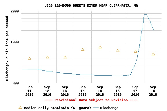 USGS 12040500 09/18/16 12:30 PDT 1320 CFS 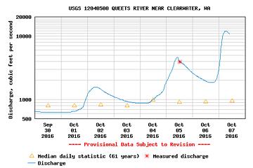 USGS 12040500 10/07/16 09:30 PDT 10800 CFS  ====================================================================================================================
On the Tshletshy Creek Trail:
Farthest up I've ever been was right up the creek with my older brother all the way to the bottom of the canyon, the same day Neil Armstrong landed on the moon.
Use the search function and dig through the other threads on that one:
here
here
here
here
If you pick through all of those carefully you'll find some interesting narratives.
During the first week of October 2012, Gay H., Mike D., and a friend did it:
====================================================================================================================
On the Tshletshy Creek Trail:
Farthest up I've ever been was right up the creek with my older brother all the way to the bottom of the canyon, the same day Neil Armstrong landed on the moon.
Use the search function and dig through the other threads on that one:
here
here
here
here
If you pick through all of those carefully you'll find some interesting narratives.
During the first week of October 2012, Gay H., Mike D., and a friend did it:
| Ski, in a previous trip report wrote: | | Get up another mile and a half and meet two NPS staffers and their friend, returning from an adventure down Tshletshy from the Quinault side. They say route finding was fairly straightforward above 2500, but once they got below that it turned into an unplanned-for extra day's journey- something which Mike's forelegs attested to vividly. |
It took them four days to get from the top of the Queets/Quinault divide down to the Queets trailhead.
"I shall wear white flannel trousers, and walk upon the beach.
I have heard the mermaids singing, each to each."
"I shall wear white flannel trousers, and walk upon the beach.
I have heard the mermaids singing, each to each."
|
| Back to top |
|
|
JustJoe
Member
Joined: 09 Apr 2006
Posts: 32 | TRs | Pics
|
|
JustJoe
Member
|
Tue Sep 12, 2017 9:50 am |
|
|
Hey Ski I really enjoyed your TR. Especially your "down by the river" video clip. I was able to enjoy the sweet sounds of the creek while following your report. With the words, images and audio it was almost like being there! Brilliant!
|
| Back to top |
|
|
Ski
><((((°>
Joined: 28 May 2005
Posts: 12830 | TRs | Pics
Location: tacoma |
|
Ski
><((((°>
|
Tue Sep 12, 2017 8:16 pm |
|
|
Wow! Thank you.
I ordered a new tripod ... same model as the one I broke last week .... Slik 450G ... gotta love Ebay ... $23 including shipping! Next video won't be so shaky, hopefully.
I'm hoping we'll get another decent weather window. Looks like the week of the 24th - 30th might well be what we're hoping for. Stoked after that email from Sam... maybe I can post a video of up above .... chinooks should be up there by then if we get a little bit of rain.
"I shall wear white flannel trousers, and walk upon the beach.
I have heard the mermaids singing, each to each."
"I shall wear white flannel trousers, and walk upon the beach.
I have heard the mermaids singing, each to each."
|
| Back to top |
|
|
|
|
You cannot post new topics in this forum
You cannot reply to topics in this forum
You cannot edit your posts in this forum
You cannot delete your posts in this forum
You cannot vote in polls in this forum
|
Disclosure: As an Amazon Associate NWHikers.net earns from qualifying purchases when you use our link(s). |


