| Previous :: Next Topic |
| Author |
Message |
Dante
Member


Joined: 16 Dec 2001
Posts: 2815 | TRs | Pics
|
|
Dante
Member
|
 Mon Jul 14, 2014 11:05 am |
|
|
My son and I drove up to the Dingford Creek trailhead on Sunday planning to climb to Horseshoe and Goat lakes, and then visit Le Fay, Nimue, Merlin and Myrtle Lakes on the way back to the trail.
Based on my prior experience with the Middle Fork Road, I thought it was in great shape. Up to the Taylor River junction, the construction has made it wide and flat, with a few rough or narrow spots. Past Taylor River, there are more pot holes and a few rough, rocky spots in the usual places, but still better than usual in my experience. None of it kept me from getting my car to the Dingford Creek trailhead, and I saw a couple sedans (Passat, Camry) there.
The Dingford Creek Trail is also in great shape. Up to Goat Creek, there were no obstacles (no blow-downs, mud, etc.).
My son and I didn't achieve our objectives for a couple reasons. First, we got a late start. Second, we didn't spend enough time looking for the fisherman's trail at Goat Creek. We found a pretty promising trail on the left side of Goat Creek where the Dingford Creek Trail first crosses Goat Creek. Unfortunately, it petered out, leaving us busting brush. We finally crossed Goat Creek and found the trail we later descended on. It hits the Dingford Creek Trail a little way up hill from Goat Creek on the Dingford Trail.
We finally got to Horseshoe around 2:00 pm, and took a long break at the outlet. From the outlet, it looks like you can easily traverse around the lake to the right, so we headed that way. There's a fisherman's trail around the lake on that side. We followed it past a couple pretty campsites until we hit a cliff that drops into the lake (which was not visible from the outlet). It looks like a fisherman's trail climbed above the cliff, but we decided to try the other side of the outlet. That was another mistake--we didn't find any obvious route around that side of the lake, and the brush was much thicker. By that time it was after 3:30, so we decided to call it a day and come back later with pack rafts and get an earlier start or do the trip as an overnight.
We got a good look at the trail between Horseshoe Lake and the Dingford Creek Trail on the way down. The trail doesn't look like it has seen much use recently. I only saw two other human footprints. It is difficult to follow in many places, and I wouldn't recommend it to those who don't have experience following faint trails. We lost it in a few places and had to back track. The trail is steep, brushy and there are lots of blow-downs across the trail. On the plus side, it's not muddy right now, and is well shaded all the way to the lake.
Sorry, no photos. I only took one panoramic photo of the lake from the outlet, and it didn't turn out well enough to post (I'm also too lazy  )
Edited to correct lake name (Horseshoe, not Hatchet )
Edited to correct lake name (Horseshoe, not Hatchet  ) )
|
| Back to top |
  
|
|
Backpacker Joe
Blind Hiker

Joined: 16 Dec 2001
Posts: 23956 | TRs | Pics
Location: Cle Elum |
Dante, I was up there two years ago. Its difficult to find that route from the Dingford trail, but it is there. It stays all the way to the talus at the outlet of Horseshoe.
"If destruction be our lot we must ourselves be its author and finisher. As a nation of freemen we must live through all time or die by suicide."
Abraham Lincoln
"If destruction be our lot we must ourselves be its author and finisher. As a nation of freemen we must live through all time or die by suicide."
Abraham Lincoln
|
| Back to top |
|
|
Dante
Member
Joined: 16 Dec 2001
Posts: 2815 | TRs | Pics
|
|
Dante
Member
|
Mon Jul 14, 2014 1:40 pm |
|
|
Yea, once we got on the fisherman's trail, It wasn't too hard to follow to the outlet of Horseshoe. The portion nearest the lake is the easiest to follow. It wasn't too hard to follow the fisherman's trail down from Horseshoe, although we did lose it a couple times and had to backtrack to get back on the right path.
|
| Back to top |
|
|
puzzlr
Mid Fork Rocks

Joined: 13 Feb 2007
Posts: 7220 | TRs | Pics
Location: Stuck in the middle |
|
puzzlr
Mid Fork Rocks
|
Tue Jul 15, 2014 2:46 am |
|
|
I agree that the trail is hard to find, even after you know generally where it is! Was a raft still stashed under a rock by one of the campsites? This photo was taken in Oct, 2013
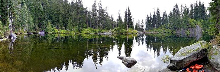 Horseshoe Lake. Someone left a rubber raft under the rock at right
|
| Back to top |
|
|
Dante
Member
Joined: 16 Dec 2001
Posts: 2815 | TRs | Pics
|
|
Dante
Member
|
Tue Jul 15, 2014 2:16 pm |
|
|
I don't think so. I think we visited every campsite on the right side of the lake from the outlet and we didn't see anything that didn't belong there except some Pistachio shells and remains of helium baloons...
|
| Back to top |
|
|
Am0ngTh3Pin3s
Hannah

Joined: 02 Oct 2021
Posts: 11 | TRs | Pics
Location: Seattle, WA |
Dante,
I know it's been years since you posted this, but my husband and I went up Dingford Creek Trail to Horseshoe Lake and on the way, we also found a balloon. Quite a coincidence, huh? 
|
| Back to top |
|
|
|
|
You cannot post new topics in this forum
You cannot reply to topics in this forum
You cannot edit your posts in this forum
You cannot delete your posts in this forum
You cannot vote in polls in this forum
|
Disclosure: As an Amazon Associate NWHikers.net earns from qualifying purchases when you use our link(s). |


