| Previous :: Next Topic |
| Author |
Message |
Justus S.
Member


Joined: 17 Nov 2004
Posts: 1298 | TRs | Pics
Location: WA |
Peak 5003 (Relic Trail, north of Curry Gap)
Did an easier hike today. Drove over Jack Pass and up to the North Fork Sky trailhead. Had a nice pleasant walk up to Curry Gap. Managed to stay pretty dry until after the pass where the brush was hanging over the trail a bit more. The brush was wet from the previous days rain. It's dry now. Anyways, at a convenient point I left the trail to head toward the saddle south of the summit. I hit the ridgeline a bit south of the saddle. I then headed up the ridge to the treed summit. You have to battle some minor brush/trees and cobwebs. As it opens up near the summit stay to the west side since its a bit easier travel. Some open areas around the summit give nice views of the major surrounding peaks. Mosquitoes pretty hungry up at the summit area as well. Anyway, not the most exciting trip but good for exercise.
 Curry Gap Flowers 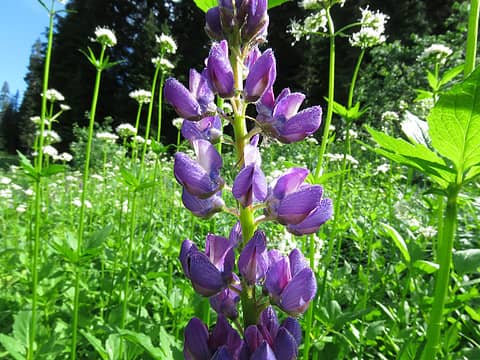 Curry Gap flowers 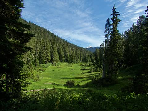 Saddle Meadows with view out to Glacier Peak 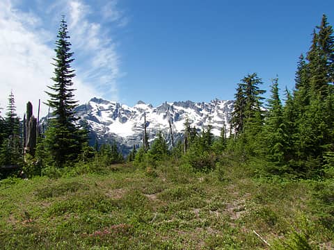 Views approaching summit  Black and Glacier Peak 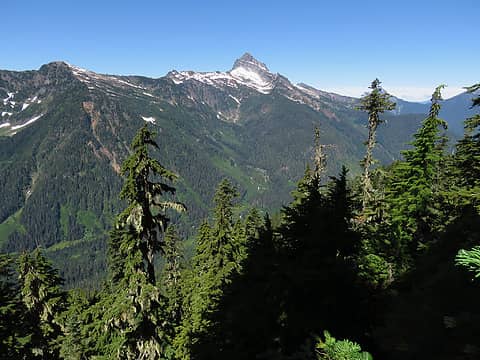 Sloan 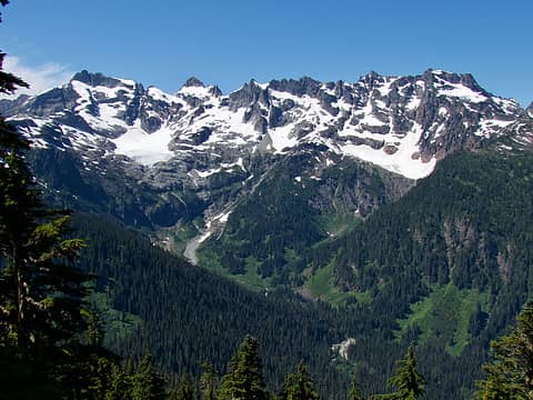 Cristos 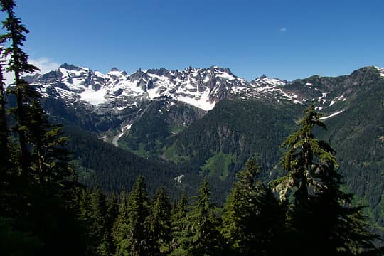 Kyes, Monte Cristo, Cadet, Foggy 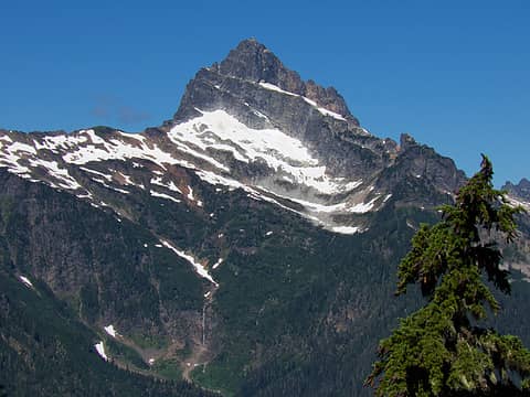 Sloan 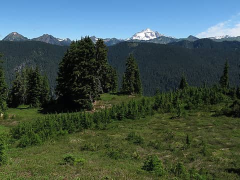 Red to Glacier to Portal 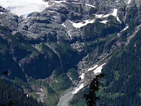 Pride Basin 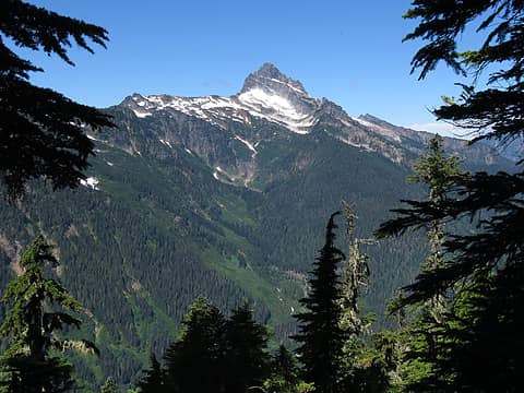 Sloan through the Trees
 contour5, Slim, ONELUV1, jaysway, JimK, ozzy, hikerbiker, RichP, Schroder, awilsondc, Nancyann, shane w, raising3hikers, olderthanIusedtobe contour5, Slim, ONELUV1, jaysway, JimK, ozzy, hikerbiker, RichP, Schroder, awilsondc, Nancyann, shane w, raising3hikers, olderthanIusedtobe
contour5, Slim, ONELUV1, jaysway, JimK, ozzy, hikerbiker, RichP, Schroder, awilsondc, Nancyann, shane w, raising3hikers, olderthanIusedtobe |
| Back to top |
  
|
|
Chief Joseph
Member

Joined: 10 Nov 2007
Posts: 7709 | TRs | Pics
Location: Verlot-Priest Lake |
Really nice photos!
Go placidly amid the noise and waste, and remember what comfort there may be in owning a piece thereof.
Justus S.
Go placidly amid the noise and waste, and remember what comfort there may be in owning a piece thereof.
Justus S.
|
| Back to top |
|
|
Schroder
Member

Joined: 26 Oct 2007
Posts: 6722 | TRs | Pics
Location: on the beach |
|
Schroder
Member
|
 Sun Aug 07, 2022 10:59 am |
|
|
I spent quite a bit of time around Curry Gap in the late 80's & early 90's after they punched a new road up Cadet Creek to within a mile of Curry Gap. I never knew there would be views like that from this peak & I'm sorry I missed it.
Justus S.
Justus S. |
| Back to top |
|
|
RichP
Member

Joined: 13 Jul 2006
Posts: 5634 | TRs | Pics
Location: here |
|
RichP
Member
|
Sun Aug 07, 2022 11:37 am |
|
|
Speaking of Curry Gap, The USGS map shows "ruins" there. Anybody know the history behind them?
|
| Back to top |
|
|
Justus S.
Member
Joined: 17 Nov 2004
Posts: 1298 | TRs | Pics
Location: WA |
Glad folks enjoyed the photos. Rich, I haven't looked closely for any ruins near the gap. Maybe an old cabin/ shelter might have been there?
RichP
RichP |
| Back to top |
|
|
Schroder
Member
Joined: 26 Oct 2007
Posts: 6722 | TRs | Pics
Location: on the beach |
|
Schroder
Member
|
Sun Aug 07, 2022 5:23 pm |
|
|
| RichP wrote: | | The USGS map shows "ruins" there. Anybody know the history behind them? |
I've tried to find out the history of that and found nothing. There was nothing when I first went up there.
RichP
RichP |
| Back to top |
|
|
Bruce Albert
Member
Joined: 01 Sep 2007
Posts: 160 | TRs | Pics
|
My 1902 Skykomish quad, which does show structures, shows nothing at or near Curry Gap and no trail either from north or south. The name has been ascribed to a miner in the Monte Cristo district who would pass through there on visits to a lady friend in Skykomish.
|
| Back to top |
|
|
Dusty Trale
Member
Joined: 24 Nov 2014
Posts: 49 | TRs | Pics
Location: East of Redmond |
My 1975 issue of Green Trails Map "Monte Cristo-No 143" does show "Ruins" at Curry Gap in the NW corner of the junction of the Quartz Creek Trail and the Curry Gap Trail. I checked my copy of the book, Discovering Washington's Historical Mines, Vol. 1 and it did not show any mines in the Curry Gap area. Maybe the "Ruins" were a former Forest Service Guard Station?
The map also shows "Ruins" at Glacier Basin near Monte Cristo, but that was from the old mining days.
|
| Back to top |
|
|
Bruce Albert
Member
Joined: 01 Sep 2007
Posts: 160 | TRs | Pics
|
The point marked on current maps coincides with a patch of bare ground and downed log where Ive eaten lunch many many times. Because its flat and because its relatively barren in an otherwise lush area its not hard to imagine there was once a cabin there. But, in visits going back forty plus years I dont recall an actual structure or debris from one.
The majority of the trail up Quartz Creek was relocated from one side of the drainage to the other around 1980 or so. The beginning of the old trail may still be easily located in the alder grove immediately below the Quartz Creek Bridge on Road 63(?).
|
| Back to top |
|
|
Kim Brown
Member
Joined: 13 Jul 2009
Posts: 6899 | TRs | Pics
|
Bruce, thanks for the info on the relocation of the Quartz Cr trail. I had looked for the original trailhead and didn't find it, but I was looking closer to the current trail. I actually just posted about it not long ago! I will check it out next time I go! Another mystery solved.
"..living on the east side of the Sierra world be ideal - except for harsher winters and the chance of apocalyptic fires burning the whole area."
Bosterson, NWHiker's marketing expert
"..living on the east side of the Sierra world be ideal - except for harsher winters and the chance of apocalyptic fires burning the whole area."
Bosterson, NWHiker's marketing expert
|
| Back to top |
|
|
Bruce Albert
Member
Joined: 01 Sep 2007
Posts: 160 | TRs | Pics
|
The old trail ran on the W side of the creek to a point perhaps a mile below Curry Gap.
The tread on those old trails in timber remains visibly prominent for decades, subject of course to brushy patches and blowdowns. Every few years I like to take the old West Cady Ridge trail across the way there from Quartz Creek, which is easily followed if you know where it departs from the new trail.
Brushbuffalo
Brushbuffalo |
| Back to top |
|
|
Brushbuffalo
Member

Joined: 17 Sep 2015
Posts: 1887 | TRs | Pics
Location: there earlier, here now, somewhere later... Bellingham in between |
Bruce, you seem to be one to ask. I plan on a loop trip in two weeks starting up West Cady Ridge and ending at Curry Gap, then south to our start.. Is the Quartz Creek trail in reasonable shape this year?
Passing rocks and trees like they were standing still
Passing rocks and trees like they were standing still
|
| Back to top |
|
|
Bruce Albert
Member
Joined: 01 Sep 2007
Posts: 160 | TRs | Pics
|
I have not been on it this year, but I wouldnt hesitate to go that way to complete that loop. There are a few sections where the annuals get a bit thick but Ive always blasted right through, and it was just fine last summer.
That is a wonderful and consistently scenic loop, doable in a long day but deserving of several
one of my favorite places on earth. This time of this year a couple of multi mile long stretches will be waterless.
chiwakum
chiwakum |
| Back to top |
|
|
Kim Brown
Member
Joined: 13 Jul 2009
Posts: 6899 | TRs | Pics
|
It's usually in good condition. Glacier Peak Institute kids did some work on it earlier this year. What a fantastic loop you have planned!
"..living on the east side of the Sierra world be ideal - except for harsher winters and the chance of apocalyptic fires burning the whole area."
Bosterson, NWHiker's marketing expert
"..living on the east side of the Sierra world be ideal - except for harsher winters and the chance of apocalyptic fires burning the whole area."
Bosterson, NWHiker's marketing expert
|
| Back to top |
|
|
|
|


