| Previous :: Next Topic |
| Author |
Message |
Now I Fly
Member

Joined: 07 Jun 2018
Posts: 465 | TRs | Pics
|
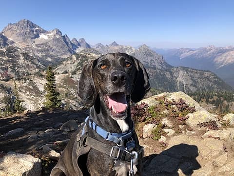
Big changes. I would love to know more.
Brian
|
| Back to top |
  
|
|
Joey
verrry senior member

Joined: 05 Jun 2005
Posts: 2797 | TRs | Pics
Location: Redmond |
|
Joey
verrry senior member
|
 Tue Aug 09, 2022 4:25 pm |
|
|
 JeremyJ JeremyJ |
| Back to top |
|
|
philfort
Member

Joined: 02 Sep 2003
Posts: 443 | TRs | Pics
Location: seattle |
|
philfort
Member
|
Tue Aug 09, 2022 5:02 pm |
|
|
|
| Back to top |
|
|
philfort
Member
Joined: 02 Sep 2003
Posts: 443 | TRs | Pics
Location: seattle |
|
philfort
Member
|
Tue Aug 09, 2022 5:07 pm |
|
|
Hmm, I just looked at the sentinelhub satellite photos, and it does look like they've done a bunch of clearcutting not related to road building.... 
|
| Back to top |
|
|
Joey
verrry senior member
Joined: 05 Jun 2005
Posts: 2797 | TRs | Pics
Location: Redmond |
|
Joey
verrry senior member
|
Tue Aug 09, 2022 5:16 pm |
|
|
When we did the hike earlier this year we met another couple on the trail who had encountered a USFS person. The couple said that asked about the various signs/flagging and were told it was a "selective" cut and some trees would be removed by air so there will be less damage to the ground.
When the work is done we will learn the new reality - whatever it turns out to be.
|
| Back to top |
|
|
puzzlr
Mid Fork Rocks

Joined: 13 Feb 2007
Posts: 7220 | TRs | Pics
Location: Stuck in the middle |
|
puzzlr
Mid Fork Rocks
|
Tue Aug 09, 2022 9:08 pm |
|
|
Now I Fly - Thanks for following the new road and posting photos. This is an implementation of part of the Hansen Creek Vegetation Project for which an EA was published in 2015. An initial decision for Alternative 3 was made in June 2015, and as I read it, the push back from the hiking community (including WTA and probably others) forced them to scale back logging surrounding the Granite/Pratt Lake trailhead. A second decision for a modified Alternative 4 was made in August, 2015.
I have mixed feeling about this activity. Forest thinning is a proven way to reduce the possibility of devastating fires by removing some of the fuel. But the "thinning" always seems to come with new roads pushed into areas to be thinned. There was an earlier round of thinning just west of this area not too many years ago -- I'm sure some of you saw those new roads branching off 9031. At least the ALW boundary keeps these logging areas close to I90.
All the project documents are here. Download now if you want to keep them -- they don't leave these project files up forever.
| Quote: | | The Decision Notice and Finding of No Significant Impact (DN-FONSI) for the Hansen Creek Vegetation Project Environmental Assessment (EA) are presented here. The following pages summarize my rationale for choosing Alternative 4 as modified in this decision, as the selected alternative.
An open and inclusive approach was used to make this decision. My intent is to continue with this approach as we implement the project. I recognize the importance the general public places on recreational and scenic opportunities in the I-90 corridor, and the project area. I expect any needed adjustments will be made during implementation by emphasizing monitoring, ongoing involvement, and consultation with the interdisciplinary team. My decision is based on the best available science and most reliable information currently on hand. I feel this decision represents a balance of the social and natural resource management needs in the project area.
Throughout the development of this EA, I considered public input and analysis completed by resource specialists. Some examples include: numerous mitigation measures designed to buffer aquatic resources in the project area to ensure their protection; visual screens of 75 to 150 feet are planned for the trails in the project area; and temporary trail closures will be limited in number and season. By modifying Alternative 4 for this decision, I am responding to public concerns raised over treating vegetation near the Pratt Lake Trail (unit 18.1), use of the Ira Spring Trail (end of Forest Service Road 9031) for harvest activities, and treating vegetation in units 18.1 and 18.2 (this stand is older than others in the project area). In addition, I am adding an early-season timing restriction to several harvest units within the Talapus Lake historical spotted owl estimated core range. In my judgement, this decision will responsibly protect and manage natural resources, and provide opportunities for the public to enjoy the National Forest. |
Re the new road -- it is one that was proposed as a new road in the original document
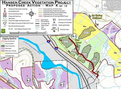 Marked up / selective section of EA map for the Ira Spring area. 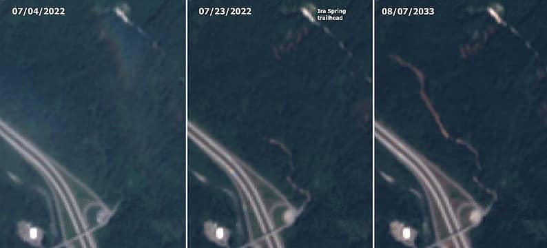 Sentinal hub aerials showing progress of new road being built in the last month
|
| Back to top |
|
|
Malachai Constant
Member

Joined: 13 Jan 2002
Posts: 16092 | TRs | Pics
Location: Back Again Like A Bad Penny |
Well it WAS a nice way to avoid the parking problems at the Ira Spring TH and get a nice walk in the woods. So it goes. 
"You do not laugh when you look at the mountains, or when you look at the sea." Lafcadio Hearn
dixon
"You do not laugh when you look at the mountains, or when you look at the sea." Lafcadio Hearn
dixon
|
| Back to top |
|
|
solohiker
Member
Joined: 23 Jan 2004
Posts: 1081 | TRs | Pics
Location: issaquah |
I parked at 42 today and did Mt Defiance. Noticed the same construction, but the trail through the woods to Ira Spring Parking lot was same as I remembered- sort of. Turned out 9031 was open today (heard from someone in the parking lot that only 9030 to Talapus TH closed), but honestly I like exit 42 access better for Ira Spring anyway.
I have never been lost, but I'll admit to being confused for several weeks. - Daniel Boone
I have never been lost, but I'll admit to being confused for several weeks. - Daniel Boone
|
| Back to top |
|
|
solohiker
Member
Joined: 23 Jan 2004
Posts: 1081 | TRs | Pics
Location: issaquah |
On thinning away tinder - There was a small fire presumably from lightning strike last night at the base of a tree with noticeable lightning strike damage. It was located on the Mt defiance trail about a mile after the rainbow lake intersection. A hiker coming down had noticed it and did a great job dousing it with what water he had and stirred up the surrounding ground.
I have never been lost, but I'll admit to being confused for several weeks. - Daniel Boone
gb, thunderhead, Cyclopath
I have never been lost, but I'll admit to being confused for several weeks. - Daniel Boone
gb, thunderhead, Cyclopath
|
| Back to top |
|
|
Now I Fly
Member
Joined: 07 Jun 2018
Posts: 465 | TRs | Pics
|
That was me. :-)
thunderhead, solohiker, Cyclopath, Malachai Constant, HikingBex, SpookyKite89, Joey, ChinookPass, mosey, zimmertr
thunderhead, solohiker, Cyclopath, Malachai Constant, HikingBex, SpookyKite89, Joey, ChinookPass, mosey, zimmertr |
| Back to top |
|
|
Now I Fly
Member
Joined: 07 Jun 2018
Posts: 465 | TRs | Pics
|
Joey |
| Back to top |
|
|
Kim Brown
Member
Joined: 13 Jul 2009
Posts: 6899 | TRs | Pics
|
With the exception of the "s" on the end of "Ira Spring," in the document, which drives me crazy, I personally don't see an issue, but haven't paid much attention to this since it was developed years ago.
As already pointed out, it's been planned. It's legal. And within the USFS' jurisdiction and DNR as contractor, and the logging co. The USFS has always been a resource agency; so they're allowed to do some logging.
Along with thinning, restoration includes some clearing to promote meadows and more sunlight hitting the forest.
I would love to have old growth forest all over the place, and I hate to think about the critters terrified by any management activities like this, but it's not reasonable to expect old growth forest all over the place because it isn't. Managing the forest helps it gain that status sooner than later. Unmanaged logging won't get there anytime soon (see the Pratt River trail for instance. ugh)
Aside from temporarily not being accessible by hikers, what do folks object to?
"..living on the east side of the Sierra world be ideal - except for harsher winters and the chance of apocalyptic fires burning the whole area."
Bosterson, NWHiker's marketing expert
Now I Fly, thunderhead, ChanceShowers
"..living on the east side of the Sierra world be ideal - except for harsher winters and the chance of apocalyptic fires burning the whole area."
Bosterson, NWHiker's marketing expert
Now I Fly, thunderhead, ChanceShowers
|
| Back to top |
|
|
philfort
Member
Joined: 02 Sep 2003
Posts: 443 | TRs | Pics
Location: seattle |
|
philfort
Member
|
Wed Aug 10, 2022 9:19 am |
|
|
It's kind of scrappy/unhealthy-looking forest there anyway, but the way it's being marketed as a "vegetation project" seems really deceptive. Like lying on your resume. The fact that it's named after a creek nowhere near the site doesn't help either 
|
| Back to top |
|
|
Kim Brown
Member
Joined: 13 Jul 2009
Posts: 6899 | TRs | Pics
|
A small section of it is at Hansen Creek though. I wonder if the Hansen Creek project was already underway and they expanded it, keeping the name. I suppose Snoqualmie Vegetation Management Plan is too ambiguous, given the multiple other management operations that go on.
Or they didn't want to re-do all the paperwork for a separate project. !
"..living on the east side of the Sierra world be ideal - except for harsher winters and the chance of apocalyptic fires burning the whole area."
Bosterson, NWHiker's marketing expert
"..living on the east side of the Sierra world be ideal - except for harsher winters and the chance of apocalyptic fires burning the whole area."
Bosterson, NWHiker's marketing expert
|
| Back to top |
|
|
bccarlso
Member
Joined: 05 Aug 2011
Posts: 174 | TRs | Pics
Location: Tacoma |
|
bccarlso
Member
|
Wed Aug 10, 2022 12:45 pm |
|
|
Can someone give me the rundown on how to use the Sentinel HUB satellites to get imagery like what's in this post? Just checking it out for the first time.
|
| Back to top |
|
|
|
|


