Forum Index > Trip Reports > The Skagit Sufferfest: Coal, Little Deer, Lumberjack, and Iron (9/12/22)
 Reply to topic
Previous :: Next Topic
Author Message
wyattmullen
Wyatt


Joined: 22 Oct 2021
Posts: 41 | TRs | Pics
Location: Skagit County
wyattmullen
Wyatt
PostTue Sep 13, 2022 4:45 pm 
Most of you will never had heard of any of these peaks before and those that have may simply ask, why? I’m not sure I can give a satisfying answer to that question, but I can at least provide a little beta for the masochists out there that are looking to climb these obscure, but prominent peaks. I was studying the Skagit 1k prominence list earlier this year and I noticed a cluster of peaks near the Finney Cumberland Road (FS 17) in the Logger’s Island. All of these peaks are 4-5,000 ft, forested, have limited beta, and offer poor to nonexistent views. As an avid trail runner who’s always interested in exploring new places, I wondered if I could connect these five peaks (Coal Mountain, Little Deer Peak, Lumberjack Mountain, Lumber Mill Mountain, and Iron Mountain) into some sort of run/bushwhacking adventure. In the spring I came up with a 37 mile route with about 10,000’ of gain that utilized forest roads and a few Summitpost tracks. The real question was, when to do this route. I debated doing it in the spring to avoid some of the brush (for such a low elevation this place gets an amazing amount of snow that lasts usually into July), but I figured 30+ miles would be even more tiring in the snow. I obviously didn’t want to do it on a good weather day when there were other objectives that were much more beautiful and pleasant. And with extensive bushwhacking expected, doing it on a wet day (or even one with dew) would make the experience so much worse. Fortunately, the arrival of the smoke this past weekend provided the perfect opportunity with limited rain or dew and obscured views throughout the state. I was going to run it on Saturday or Sunday, but both days featured AQI in the 200 range which is beyond my comfortable limit for exercising outside. But Monday was right about 100, so still bad enough to not want other objective, but good enough I wouldn’t be taking years off my life by spending all day out in it. I was originally planning to start around 7 a.m., but I woke up a bit late and had a leisurely breakfast so I didn’t actually hit the forest road until 8:30. I parked at the intersection of FS 1775 (Claims Road) and FS 17 and began the gradual climb up to the 3,300’ Cumberland Pass (I’m not sure it actually has a name). The pass is actually kind of a nice meadow area and fortunately there were a ton of huckleberries and blueberries. The constant berries throughout the day definitely made this adventure more manageable. Shortly after the pass you can turn right (west) on a spur road that supposedly goes all the way up to the saddle between the north and south summits of Coal Mountain. This road was as recently as last spring blocked by a boulder right after the turnoff of NF 17, but that has been cleared and the road is in great shape for just over a mile up to 3,500’. And then the bushwhacking began for the day.
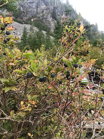
Huckleberries at Cumberland Pass
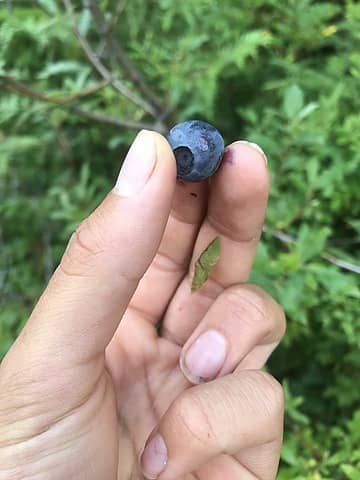
Some of them were quite sizeable
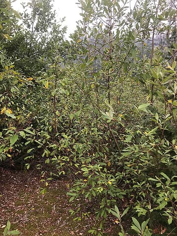
The start of the bushwhacking
It started out benign. There’s an old road choked with slide alder that continues along the northwest slope of the northern peak of Coal Mountain. It almost appears someone has hacked a path through sections of the alder, but that may just be my imagination. Anyways, I followed this road for about 2 miles. At times the slide alder got bad enough that travel through the forest was easier and I cut a couple switchbacks (although the heavy brush here may have negated any time savings), but in general I stuck to the road. Between the two summits of Coal, the road ended and I then bushwhacked up the northwest ridge to the summit (some bushy sections, some sections with steep duff) where I was greeted with 360º views of trees. The summit is a raised dirt bump with a couple trees growing out of it just to the northeast of the spot marked on maps. Unless you’re really into prominence (and this peak doesn’t even have 1,000’ of clean prominence) I wouldn’t recommend this to anyone.
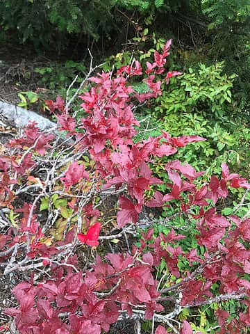
We're getting close to fall colors
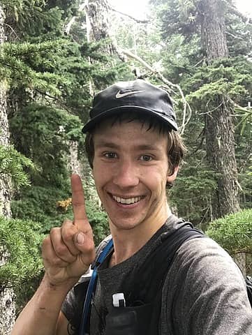
First summit of the day
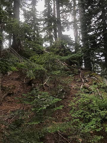
The top of Coal Mountain is really not much to look at
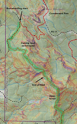
I've included CalTopo maps for any masochists out there. This is for Coal and green represents bushwhack
There is an old forest road visible on maps that cuts from the south slopes of Coal to the north slopes of Little Deer Peak. Based on satellite images it looked brushy and there is absolutely no information on Little Deer Peak (Peakbagger has only one ascent from the ubiquitous Grant Myers) so I figured this would be the most difficult leg of my journey. The descent off the south ridge of Coal was pleasant. The slope is moderate and the forest is mostly open although it gets denser as you descend. At 3,900’ I dropped east through brushy forest to what remains of the "road". I don’t know when this road was last used, but considering there were 40’ tall trees growing in the middle of it, it must have been decades ago. This was truly slide alder hell. About 5% of the road was actually open, the rest of it featured extremely dense thickets of alder with a little devil’s club and salmonberries thrown in. My progress slowed to less than 1 mile an hour and I spent just as much time with my feet on the alder branches as on the road. At times I headed into the forest and made decent progress, but steep slopes and brush would eventually force me back. I kept expecting the brush to eventually get better, but as I approached Little Deer Peak it only got thicker. Three miles of this was enough to drive anyone insane. Eventually I reached the steep northern slope of Little Deer. After stopping for a quick bite to eat I made my way up between thin strands of forest and extremely brushy avalanche gullies. The vegetation was essential to help me gain any elevation and the veggie belays on the way down were even more helpful. At about 3,800’ you reach a boulder field which provided some of the nicest off-trail travel all day. I imagine this would offer decent views to the north, but by this point the smoke had thickened further and I couldn’t see any of the nearby hills. To avoid cliff bands at 4,100’ I cut left over a couple of brushy benches (the route is relatively clear if you look at slope angles) and then ascended steep forest and performed a little bit of class 3 climbing to ascend some dry mossy slabs. You can avoid the slabs if you stay far enough to the right, but this whole area would be a slip and slide if at all wet. Once I reached the southwest ridge it was easy travel to the summit which had pretty good views to the north, but not much else. Little Deer Peak with its slabs and boulder field was the most alpine feeling peak of the day, but probably still not worthy of a visit (especially considering the horrible bushwhacking to get out there).
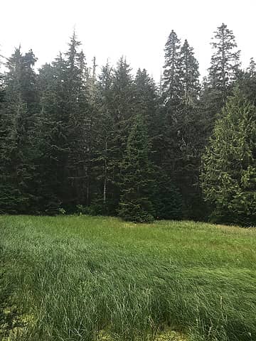
Kind of a cool meadow on the way to Little Deer
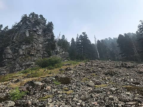
Little Deer's boulder field
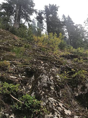
Some mossy slabs on Little Deer which would be unpleasant when wet
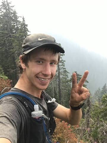
Second summit of the day
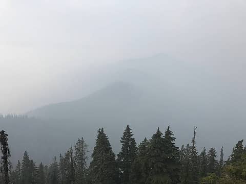
So much for saving my lungs from the smoke
Little Deer Peak was about 1.5 hours roundtrip from the road and I fell numerous times on the descent getting some nice scratches on my arms and legs. At least I had a short reprieve from the slide alder which resumed as I followed the road to the north. At first the slide alder was improbably even thicker than I had dealt with earlier, but within a half mile it began to thin and 3/4 of a mile after my Little Deer detour (where an easterly branching spur rejoins the road) a narrow trail opened up in the branches. Travel became even easier a half mile later when I passed another spur and all I had to do to avoid the alder was duck slightly. I was carrying 3 liters of water capacity with me because I wasn’t sure how much I would encounter on the day, but there was a big stream that drains off of Little Deer and a crumbling bridge where I stopped to fill up water. After that the road continued to improve and I was able to run most of the next five miles to the base of Lumberjack. I thought briefly about bailing when I passed the intersection with FS 17 since I’d been out for 8 hours and covered less than half my distance, but I figured the worst was behind me.
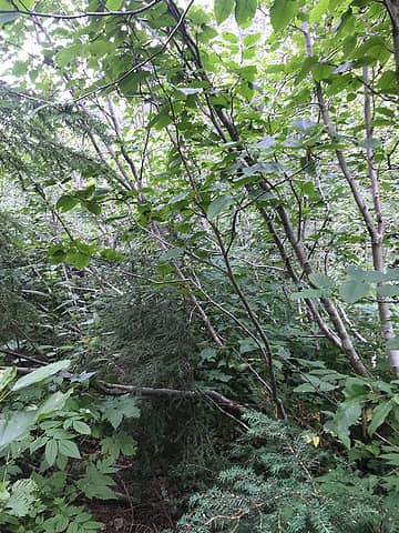
A slightly better section of the road near Little Deer
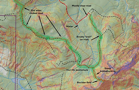
Little Deer Peak featuring the worst bushwhacking of the day
Summitpost lists two possible routes up Lumberjack. I decided to ascend one and descend the other to give me access to Lumber Mill and Iron. I left FS 17 at 2,700’ and climbed through a small clear cut before entering mostly open forest. There are a couple steep sections as you ascend, but nothing too bad. However, the brush got progressively worse as I climbed. It was not particularly bad compared to earlier in the day, but there was a surprising amount of Devil’s Club on the slopes which was hard to avoid. The climb up is about 2,000’ in a mile and once I got to the western summit ridge it was easy enough to follow to the top. This was the only summit of the day I saw a summit register on, although unfortunately the pillbox used had not stood up to the elements and had gotten a sizeable hole in the bottom that had dissolved any register inside. Some peek-a-boo views to the north at the summit, but everything else was pretty restricted. Considering its relatively easy access from the road, this was the first peak of the day that I could give a tentative recommendation. Not that it’s good or anything, it’s just less bad than than the others.
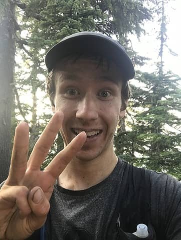
A little crazed on the third summit of the day
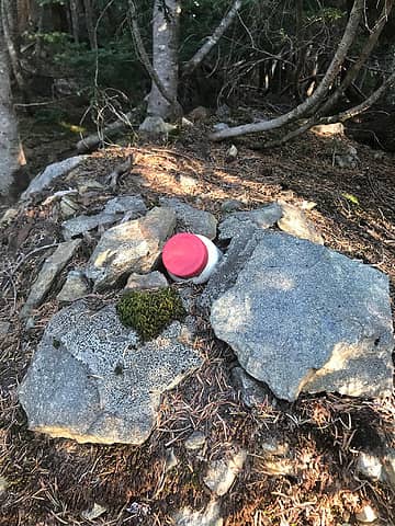
The only summit register of the day which had completely dissolved
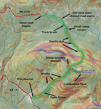
Lumberjack peak with all its devil's club greatness
The descent off the north side of Lumberjack follows the ridge and then zigzags through a couple steep cliff bands. Since the climb hadn’t been too challenging I thought the descent could be completed quickly. This was not the case. Lumberjack Mountain should maybe more aptly be named devil’s club mountain. Once I dropped a couple hundred feet off the summit ridge there was the spiny bane of bushwhackers everywhere. Every single drainage was choked with it and it seemed more or less continuous for the next mile and a half. Some logs gave me the opportunity to travel relatively unencumbered, but eventually I always had to drop back into it. The final challenge of this section was crossing the marshy headwaters of Pressentin Creek. It seemed like the terrain map was taunting me when I came to the creek and found a steep 50’ canyon that I had to descend to get to the forest on the other side.
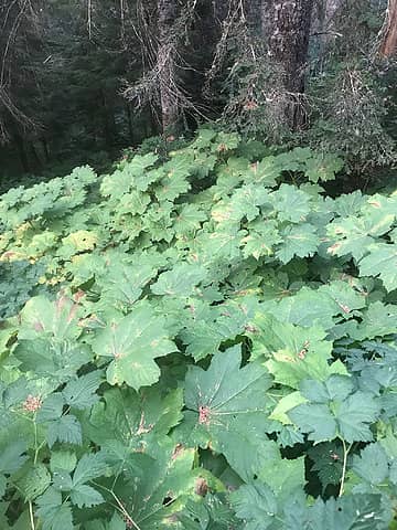
So much devil's club
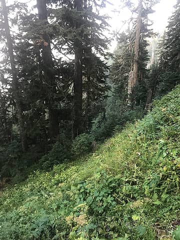
Steep side hilling on the north face of Lumberjack
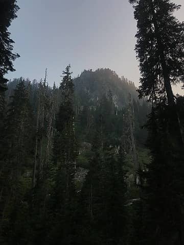
The last light of the day highlighting a sub summit of Lumberjack
I knew that if I kept climbing up I’d eventually reach a decommissioned part of FS 1775. Of course the forest immediately before this was the thickest bushwhacking of the day and it was with desperation that I clawed onto the brushy road, two hours and two miles after I had left the summit of Lumberjack. I had a headlamp, but I was thankful to have reached the road just as it was getting dark. Unless you want to dance with the devil, I can’t recommend this north side approach to anyone. With darkness falling I figured I’d scrap Lumber Mill (no way did I want to do an extra 4 miles of bushwhacking in the dark) and I’d finish on Iron. As darkness fell the smoke finally started to diminish and I made the 4 mile easy logging road jog to Iron. For some reason I thought Iron was a drive-up (despite my map clearly suggesting this was not the case). I approached the south side and got within 400 feet of the summit on a small spur road before heading into the trees. This was some of the most open forest of the day and was pretty nice to ascend despite the darkness being complete. Before I knew it I was on the summit where there was a cairn and I had some partially obscured views to the lights of the Skagit Valley below. A very smoky orange moon began to rise as I figured I had an easy jog all the way to the car, but it turns out I had one last section of bushwhacking left. In the light this descent would have been trivial, but I really did think there was a trail or a road nearby so I kind of stumbled around in the dark repeatedly running into cliff bands and dense brush. 100’ before the road the forest continued to thicken, but by that time I could taste the end and finally broke out onto the road with shouts of joy.
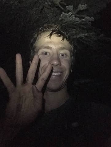
Darkness on the final summit
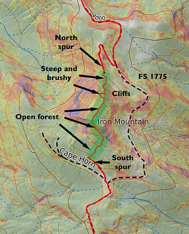
Iron Mtn has the most beta, but good to know the south side is better than the north
Iron Mountain was definitely the easiest peak of the day, although coming in or descending off the north ridge is not recommended. After reaching the road it was about 6 miles of nice, runnable, downward-trending forest road to my car. There are actually some great views of Baker on this road so the road is probably the only reason worth coming up here. I reached my car at 10:30 p.m., 14 hours, 8,700’, and 34 miles after starting. In all I was pretty happy with how the day went. It was meant to be a mentally and physically challenging day to explore a remote corner of the county. I definitely could have used maybe one or two miles fewer of slide alder and devil’s club, but otherwise I felt like being able to keep a positive attitude throughout the day will help me immensely with later bushwhacking for more impressive objectives. It also helped me develop a ranking system for veggie belays. In case you’re wondering, blueberries are probably the best (especially when they’re ripe) followed by evergreen tree branches. There’s a lot of forgettable plants in the middle and then at the bottom you have salmonberries which are unpleasant but sometimes useful as a last resort. Of course devil’s club should never, ever be used as a belay, but I'm sure you already knew that.

Fred Beavon, RichP, Matt, geyer, brewermd, Bramble_Scramble  Gimpilator  jaysway
Back to top Reply to topic Reply with quote Send private message
Stefan
Member
Member


Joined: 17 Dec 2001
Posts: 5091 | TRs | Pics
Stefan
Member
PostTue Sep 13, 2022 4:55 pm 
Uh. hell yeah. thanks for the info!

Art is an adventure.
Back to top Reply to topic Reply with quote Send private message
Gimpilator
infinity/21M


Joined: 12 Oct 2006
Posts: 1684 | TRs | Pics
Location: Edmonds, WA
Gimpilator
infinity/21M
PostTue Sep 13, 2022 6:23 pm 
Very cool. Wish there were more reports like this one. up.gif up.gif

Summitpost | YouTube | Peakbagger

Bramble_Scramble
Back to top Reply to topic Reply with quote Send private message
geyer
Member
Member


Joined: 23 May 2017
Posts: 463 | TRs | Pics
Location: Seattle
geyer
Member
PostTue Sep 13, 2022 7:58 pm 
Haha that's some serious dumpster diving! Way to get after it

slabbyd
Back to top Reply to topic Reply with quote Send private message
RichP
Member
Member


Joined: 13 Jul 2006
Posts: 5634 | TRs | Pics
Location: here
RichP
Member
PostWed Sep 14, 2022 5:24 am 
Dude, I like your style. cool.gif

Back to top Reply to topic Reply with quote Send private message
Sculpin
Member
Member


Joined: 23 Apr 2015
Posts: 1384 | TRs | Pics
Sculpin
Member
PostWed Sep 14, 2022 7:04 am 
This one is right up there with the dudes who went up to Cave Ridge and dug in the snow. uhoh.gif

Between every two pines is a doorway to the new world. - John Muir
Back to top Reply to topic Reply with quote Send private message
Sultan Guy
Member
Member


Joined: 22 Jul 2008
Posts: 353 | TRs | Pics
Location: Now reinforced with Concrete
Sultan Guy
Member
PostWed Sep 14, 2022 7:19 am 
Nice work! If you would like some additional local "suffer-fest" go for Finney Peak. Local tip-Don't use the old route 1735 as it is REALLY overgrown. Best approach is through large timber on NE side. There are a few other peaks in this area I have done, but most have less then your 1,000' prominence.

Any worthwhile expedition can be planned on the back of an envelope- H. W. Tilman

RichP
Back to top Reply to topic Reply with quote Send private message
awilsondc
Member
Member


Joined: 03 Apr 2016
Posts: 1324 | TRs | Pics
awilsondc
Member
PostWed Sep 14, 2022 7:51 am 
This is rad... it takes a certain type of person to do a trip like this. There aren't many of them. Nicely done!

Alden Ryno
Back to top Reply to topic Reply with quote Send private message
Matt
Tea, Earl Grey, Hot


Joined: 30 Jan 2007
Posts: 4307 | TRs | Pics
Location: Shoreline
Matt
Tea, Earl Grey, Hot
PostWed Sep 14, 2022 11:54 am 
Yep, that's a lot of bushwhacking to get a group of peaks.

“As beacons mountains burned at evening.” J.R.R. Tolkien
Back to top Reply to topic Reply with quote Send private message
Redwic
Unlisted Free Agent


Joined: 23 Feb 2009
Posts: 3292 | TRs | Pics
Location: Going to the Prom(inence)
Redwic
Unlisted Free Agent
PostThu Sep 15, 2022 7:01 am 
Good work!

60 pounds lighter but not 60 points brighter.
Back to top Reply to topic Reply with quote Send private message
   All times are GMT - 8 Hours
 Reply to topic
Forum Index > Trip Reports > The Skagit Sufferfest: Coal, Little Deer, Lumberjack, and Iron (9/12/22)
  Happy Birthday Traildad!
Jump to:   
Search this topic:

You cannot post new topics in this forum
You cannot reply to topics in this forum
You cannot edit your posts in this forum
You cannot delete your posts in this forum
You cannot vote in polls in this forum