| Previous :: Next Topic |
| Author |
Message |
raising3hikers
Member


Joined: 21 Sep 2007
Posts: 2344 | TRs | Pics
Location: Edmonds, Wa |
Heather Ridge 7928'
A Heather Ridge TR? Where's that peak at?
Heather Ridge is located in between Company Cr and Agnes Cr, West of Stehekin. It's in the neighborhood of Dark Pk. Since the Stehekin shuttle stopped running earlier this month, I chose to start my trip from highway 20 at the Bridge Cr TH instead. It would involve many more miles (22 to camp) but gave me the luxury of doing things on my own time frame. The bad thing is that the TH starts at ~4500', and eventually drops down to less than ~1500' at the Agnes creek bridge. Easy on the way in but lots of gain on the way out.
I started hiking a little after 815 on Friday morning. Somewhat hazy skies but oh well, I would be descending into the forest for the day. I ran into lots of hikers on the PCT as I enjoyed the nicely maintained trail. The views to the West became more hazy as the day went on. There were a couple good streams for water, especially Maple Cr. I made my way down to High Bridge, where I'd taken the shuttle to a few times. I made it there earlier than the shuttle would have if it was running anyways. Then I took the Agnes Cr/PCT S trail another 5 miles to Pass Cr where I'd set camp below Heather Ridge. It took 6hrs 40 min to reach camp, I had plenty of daylight left to set camp and eat dinner. Pass Cr was flowing nicely, so getting water was no problem.
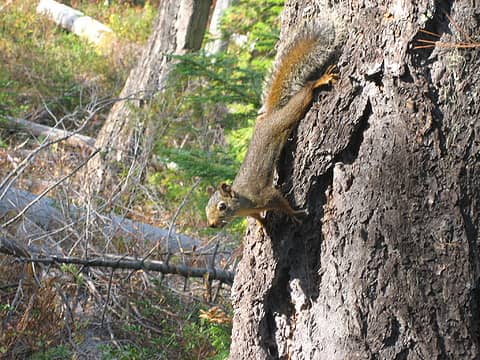 a playful squirrel 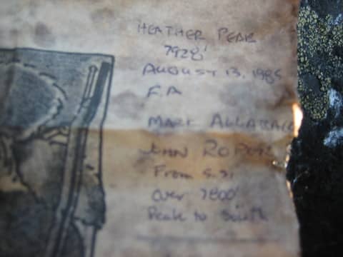 FA Roper/Alleback register 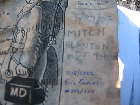 the other names on the register 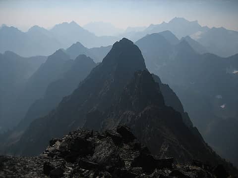 view of Pk 7800 to the S 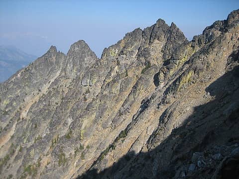 looking back to all the false summits and typical terrain on Heather Ridge
Eric Eames
 freddyfredpants, pwrobinson, Gimpilator, Eric Gilbertson, geyer, awilsondc, williswall, SeanSullivan86, silence, mosey, rubywrangler, Prosit, LukeHelgeson, Bramble_Scramble freddyfredpants, pwrobinson, Gimpilator, Eric Gilbertson, geyer, awilsondc, williswall, SeanSullivan86, silence, mosey, rubywrangler, Prosit, LukeHelgeson, Bramble_Scramble  Off Route Randy, ozzy Off Route Randy, ozzy
Eric Eames
freddyfredpants, pwrobinson, Gimpilator, Eric Gilbertson, geyer, awilsondc, williswall, SeanSullivan86, silence, mosey, rubywrangler, Prosit, LukeHelgeson, Bramble_Scramble Off Route Randy, ozzy
|
| Back to top |
  
|
|
Prosit
Member
Joined: 08 May 2011
Posts: 130 | TRs | Pics
|
|
Prosit
Member
|
 Mon Oct 10, 2022 9:25 pm |
|
|
Nice one! That summit has a nice position, and its really a shame about the smoke. I would have liked to see that perspective of Agnes.
Beckey writes about an "easy" route going up the Pass Creek valley, then straight up and finishing on the south of the peak, does that sound reasonable to you based on your climb?
He also calls pt 7800+ "Cassiope", so it sounds like it has also been climbed in similar fashion. Actually, now I see in your picture that Roper went over 7800+ to get to Heather Ridge. That looks like quite a ridge to traverse.
Thanks for the report.
|
| Back to top |
|
|
iron
Member

Joined: 10 Aug 2008
Posts: 6392 | TRs | Pics
Location: southeast kootenays |
|
iron
Member
|
Tue Oct 11, 2022 12:09 am |
|
|
looks like the 'real' ragged ridge.
the t300 list sure has taken you to some nice spots. t400, queue it up...
|
| Back to top |
|
|
silence
Member

Joined: 25 Apr 2005
Posts: 4420 | TRs | Pics
|
|
silence
Member
|
Tue Oct 11, 2022 6:56 am |
|
|
PHOTOS
FILMS
Keep a good head and always carry a light bulb. Bob Dylan
|
| Back to top |
|
|
geyer
Member

Joined: 23 May 2017
Posts: 463 | TRs | Pics
Location: Seattle |
|
geyer
Member
|
Tue Oct 11, 2022 6:07 pm |
|
|
I was browsing my pics from a couple weekends ago and was surprised to see heather ridge in this view. Nice work getting this one! You're making my obscurity list seem not so obscure lately
raising3hikers
raising3hikers |
| Back to top |
|
|
raising3hikers
Member
Joined: 21 Sep 2007
Posts: 2344 | TRs | Pics
Location: Edmonds, Wa |
| Prosit wrote: | | Beckey writes about an "easy" route going up the Pass Creek valley, then straight up and finishing on the south of the peak, does that sound reasonable to you based on your climb? |
It looked ok if coming up from the pass creek valley, long gullies that aren't too steep. The problem looks like the traverse into/out of the valley that has many avy swaths to go through with lots of possible slide alder to deal with. I thought about descending that way until I saw the amount of swaths with the possibility of much difficulty. I looked at the satellite before planning the trip and that's why I chose to take a high traverse.
Eric Eames
Prosit
Eric Eames
Prosit
|
| Back to top |
|
|
Stefan
Member

Joined: 17 Dec 2001
Posts: 5093 | TRs | Pics
|
|
Stefan
Member
|
Thu Oct 13, 2022 1:49 pm |
|
|
Uh. 53 miles. What??? No way would I do that in 3 days!
Good on you. Dang!!!
|
| Back to top |
|
|
ozzy
The hard way

Joined: 30 Jul 2015
Posts: 476 | TRs | Pics
Location: University place, wa |
|
ozzy
The hard way
|
Thu Oct 13, 2022 6:22 pm |
|
|
A third ascent! That's f### sweet dood!  killer trip and you're making it look easy as usual. Pretty burly stats for that hike! Another peak I've never heard of, you are the king of obscurity! killer trip and you're making it look easy as usual. Pretty burly stats for that hike! Another peak I've never heard of, you are the king of obscurity! 
I dont know whats gonna happen, but I wanna have my kicks before the whole shithouse goes up in flames-Mr Mojo Risin
I dont know whats gonna happen, but I wanna have my kicks before the whole shithouse goes up in flames-Mr Mojo Risin
|
| Back to top |
|
|
|
|
You cannot post new topics in this forum
You cannot reply to topics in this forum
You cannot edit your posts in this forum
You cannot delete your posts in this forum
You cannot vote in polls in this forum
|
Disclosure: As an Amazon Associate NWHikers.net earns from qualifying purchases when you use our link(s). |


