| Previous :: Next Topic |
| Author |
Message |
Joey
verrry senior member


Joined: 05 Jun 2005
Posts: 2797 | TRs | Pics
Location: Redmond |
|
Joey
verrry senior member
|
 Fri Nov 25, 2022 12:19 pm |
|
|
The headline new feature is screenshot mode (click Menu). When you turn that on then all controls are removed from the map so you can:
● Take a screenshot that is 100% map
● Shift the screen *exactly* one screen worth up/down/left/right
● Take a screenshot that is 100% map
● Shift the screen *exactly* one screen worth up/down/left/right
● Repeat as much as you like
While you are taking screenshots GISsurfer is keeping track of all the georeference data. And since the screenshots *exactly adjoin* they are easy to stitch together into a larger image. I routinely make georeferenced JPGs that cover 300+ square miles and are 25-30 screenshots stitched together.
Almost anything that GISsurfer can display can be made into georeferenced JPGs or georeferenced PNG files with a transparent background.
Here are some things you can do with georeferenced images. Instructions are included in the GISsurfer documentation.
1. Open georeferenced JPGs with GeoJPG version 2 (under development) and use them as offline maps. Actually this use is the initial reason for why I added the screenshot mode to GISsurfer.
2. If you use a Garmin GPS then you can make your own custom map by taking a large georeferenced JPG and tiling it with the freeware KMZFactory.
2. You can make a KMZ file that contains one or more images and the georeference data. That KMZ file can be opened with Google Earth, QGIS, ATAK, iTAK and with various other software.
4. GISsurfer can display georeferenced images.
https://mappingsupport.com/p2/gissurfer.php?data=Mason_Lake_small^https://geojpg.com/worker/p/map/WA/WA_small_maps/I_90_west_of_pass/WA_Mason_Lake_small_usgs.jpg^47.394631,-121.605349,47.442195,-121.517458
The GISsurfer version 3 update also includes
● Display GIS data hosted on WMS servers
● Display GIS data hosted on XYZ servers
● Documentation for using ArcGIS dynamic layers to restyle GIS data (very useful!)
● and more.
For details see the Whats New page:
https://mappingsupport.com/p2/gissurfer-whats-new.html
GISsurfer default map: https://mappingsupport.com/p2/gissurfer.php
GISsurfer homepage: https://gissurfer.com
The detailed documentation is in a series of PDF files on the 'Help' page.
 call-151, Josh Journey, jaysway, RumiDude call-151, Josh Journey, jaysway, RumiDude
call-151, Josh Journey, jaysway, RumiDude |
| Back to top |
  
|
|
contour5
Member

Joined: 16 Jul 2003
Posts: 2963 | TRs | Pics
|
|
contour5
Member
|
Fri Nov 25, 2022 11:57 pm |
|
|
Wow! Thanks, Joey!
That's a spectacular effort!
|
| Back to top |
|
|
Joey
verrry senior member
Joined: 05 Jun 2005
Posts: 2797 | TRs | Pics
Location: Redmond |
|
Joey
verrry senior member
|
Tue Nov 29, 2022 7:18 am |
|
|
Starting in December 2022 I plan to produce a series of YouTube videos to help people learn how to use the software I have developed and other resources that I am providing. Stay tuned...
Josh Journey, JonnyQuest, RumiDude
Josh Journey, JonnyQuest, RumiDude |
| Back to top |
|
|
Joey
verrry senior member
Joined: 05 Jun 2005
Posts: 2797 | TRs | Pics
Location: Redmond |
|
Joey
verrry senior member
|
Tue Dec 20, 2022 5:48 am |
|
|
Release of the GISsurfer videos is going to slip to 2023 in part because I got distracted producing a new map. This map can show (1) a wide variety of public land from federal to local and (2) private property parcel lines for 26 states including Washington.
The "Map tips" link (upper left corner) has an important disclaimer. The section "About the data" has related info.
To turn on the Washington State parcel lines, click the basemap button and look under the "Overlay" heading.
Remember you can click the 'top' layer and see all the attribute data the GIS server has for the thing that you clicked.
View larger size in new window
RichP, mike, yukon222
RichP, mike, yukon222 |
| Back to top |
|
|
altasnob
Member

Joined: 29 Aug 2007
Posts: 1406 | TRs | Pics
Location: Tacoma |
|
altasnob
Member
|
Tue Dec 20, 2022 8:05 am |
|
|
Thanks for this. It is very useful.
|
| Back to top |
|
|
Joey
verrry senior member
Joined: 05 Jun 2005
Posts: 2797 | TRs | Pics
Location: Redmond |
|
Joey
verrry senior member
|
Fri Dec 30, 2022 11:02 am |
|
|
|
| Back to top |
|
|
Joey
verrry senior member
Joined: 05 Jun 2005
Posts: 2797 | TRs | Pics
Location: Redmond |
|
Joey
verrry senior member
|
Sat Feb 04, 2023 3:16 pm |
|
|
As promised, the first four tutorial videos for GISsurfer are done. These are the first videos I have ever produced so there was a bit of a learning curve. Four more GISsurfer videos are planned and I hope to get them done this month.
If you open this YouTube link and then click the thumbnail screen image, then you will see the list of videos in order.
https://youtube.com/playlist?list=PLSxB0MlGdY3EKZi90WDJExQiG-QYeSYnG
|
| Back to top |
|
|
Joey
verrry senior member
Joined: 05 Jun 2005
Posts: 2797 | TRs | Pics
Location: Redmond |
|
Joey
verrry senior member
|
Sun Mar 05, 2023 8:43 am |
|
|
|
| Back to top |
|
|
peter707
Member
Joined: 16 Jun 2022
Posts: 136 | TRs | Pics
Location: Seattle, WA |
|
peter707
Member
|
Tue Mar 07, 2023 10:25 am |
|
|
|
| Back to top |
|
|
Joey
verrry senior member
Joined: 05 Jun 2005
Posts: 2797 | TRs | Pics
Location: Redmond |
|
Joey
verrry senior member
|
Tue Mar 07, 2023 10:44 am |
|
|
peter707 |
| Back to top |
|
|
peter707
Member
Joined: 16 Jun 2022
Posts: 136 | TRs | Pics
Location: Seattle, WA |
|
peter707
Member
|
Tue Mar 07, 2023 10:51 am |
|
|
|
| Back to top |
|
|
Joey
verrry senior member
Joined: 05 Jun 2005
Posts: 2797 | TRs | Pics
Location: Redmond |
|
Joey
verrry senior member
|
Sat Jun 17, 2023 7:51 am |
|
|
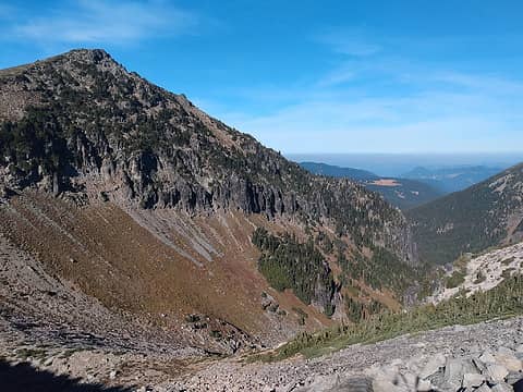
I used GISsurfer's screenshot mode to make a number of KMZ files that cover much of the Washington State Cascades. Each KMZ file includes (1) a JPG that was made by stitching GISsurfer screenshots together and (2) a KML file with the georeference data for the JPG.
One thing you can do with these KMZ files is fly over them in 3D with Google Earth Pro. This is free software which can be installed on PCs and Macs. The screenshot below is from GE Pro and I have 'flown' close to the edge of one of these KMZ files.
Links to the KMZ files are in the PDF tutorial that shows you how GISsurfer screenshot mode works. See p.16+
https://mappingsupport.com/p2/help/GISsurfer-georeference-images.pdf
There also now is a video tutorial for screenshot mode:
|
| Back to top |
|
|
|
|


