| Previous :: Next Topic |
| Author |
Message |
vogtski
Member


Joined: 03 Dec 2022
Posts: 47 | TRs | Pics
Location: Waitgate WA |
|
vogtski
Member
|
 Fri Dec 16, 2022 9:56 am |
|
|
Diagonally parked in a parallel universe
|
| Back to top |
  
|
|
vogtski
Member
Joined: 03 Dec 2022
Posts: 47 | TRs | Pics
Location: Waitgate WA |
|
vogtski
Member
|
Sat Jan 07, 2023 1:27 pm |
|
|
| Bruce Albert wrote: | | Thanks for the details. My mother related skiing the Devils Dip in the WWII era, but was slim on details and can no longer be asked. |
Devil's Dip map: http://www.hillmap.com/m/ag1zfmhpbGxtYXAtaGRychULEghTYXZlZE1hcBiAgIDJg_-iCww
The actual Dip is the way point near 5200', but the name was commonly used for the entire run from Paradise to Narada. The marked trail below Stevens Canyon Road uses bits and pieces of the abandoned first road to Paradise Valley. I have placed way points to mark the former Second and Third Crossings of Paradise River. The First Crossing was today's bridge at the Narada parking lot. Edit to add that WWII era skiers before Stevens Canyon Road would probably have had the options to stay on the west bank all the way to Narada or use Third Crossing and the unplowed road.
| Bruce Albert wrote: | | The alternate route to Van Trump leaving from the Christine Falls TH but bypassing Comet Falls to the west is safe and straightforward with adequate snow cover. It is well described in the old Mueller guide or I can do so here if asked. |
I don't have the computer skills, but that route is probably worth posting to fill out this discussion. I think it was in Prater's 'Snowshoe Guide' also. The key is "adequate snow". I seem to recall lots of brush & big (4-5') down logs on the lower gentler slopes and a tough climb through the final fluted forested big drifts on the ridgetop. It can be a great old-growth forest descent with a deep snowpack at 3500'.
There is also a better way to start from Longmire up to Rampart Ridge. Instead of turning left/west at the initial Wonderland junction and traversing back to the plowed road, start north (CCW) on the Trail of the Shadows. You will quickly reach the restored 'cabin' (Longmire's meathouse). Sidestep up the small slope behind it and find the obvious Wonderland Trail up Rampart in half the distance without removing skis/snowshoes to cross the road berms.
Diagonally parked in a parallel universe
Diagonally parked in a parallel universe
|
| Back to top |
|
|
vogtski
Member
Joined: 03 Dec 2022
Posts: 47 | TRs | Pics
Location: Waitgate WA |
|
vogtski
Member
|
Sat Jan 07, 2023 4:16 pm |
|
|
From the Mount Rainier Administrative History, under the 'Paradise' heading:
https://www.nps.gov/parkhistory/online_books/mora/adhi/chap10.htm
"Another distinctive tourist attraction during the Depression was the presence of the Civilian Conservation Corps (see Chapter XI). President Roosevelt's "Tree Army" received substantial press coverage, and tourists were curious to see these vaunted young men in action. For most of the CCC's existence, from 1933 to 1942, there were six CCC camps in Mount Rainier National Park, the most accessible one being at Narada Falls. All RNPC busses made the Narada Falls camp a regular stop for tourists enroute to Paradise. Hundreds of private automobiles also stopped at Narada Falls each day during the summer. The waterfall itself drew many onlookers, of course, but it was the camp superintendent's feeling that most people were primarily interested in seeing what a CCC camp looked like. "Owing to the fact that this camp is under constant observation by the public in general," wrote the camp superintendent, "a special attempt has been made by this camp to present a smart appearance."
"Camp Narada occupied the level ground on the far side of the stone bridge directly above Narada Falls. Beyond the decorative log entrance to the camp were a handful of permanent buildings consisting of garages, mess hall, wash houses, and tool shops. These were laid out on either side of a short section of abandoned road. Nestled against a wall of trees were the tent quarters of the company officers and men.
"Interestingly, the site was selected for a CCC camp over the protests of NPS landscape architects who thought the area ought to be restored to a natural condition. The site had formerly seen use by road crews and seasonal rangers assigned to traffic control. Some effort had been made to clean up the area in the late 1920s with the removal of an unsightly toilet building at the brink of the falls and the clearing of a mass of downed trees from the Paradise River directly above the falls. After the camp's abandonment in 1937, the landscape architects were once again thwarted, as several of the buildings remained standing for equipment."
Diagonally parked in a parallel universe
 Bruce Albert, ChinookPass Bruce Albert, ChinookPass
Diagonally parked in a parallel universe
Bruce Albert, ChinookPass
|
| Back to top |
|
|
Bruce Albert
Member
Joined: 01 Sep 2007
Posts: 160 | TRs | Pics
|
Thank you for putting up the map of the Devil's Dip.
| vogtski wrote: | | that route is probably worth posting to fill out this discussion. |
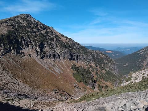
I will attempt a description: From the Van trump summer trailhead follow the west side of the creek drainage, staying well away, to a point near where the drainage makes an obvious bend to the north. At that juncture ascend away from the creek to the NW up moderate timbered slopes to reach the crest of Rampart Ridge in the vicinity of the 4,800' saddle. Follow the ridge north, passing one short steep section, to open slopes beneath Mildred Point, part way along which the deep stream swale can be crossed into Van Trump Park proper. When descending the route without benefit of an uphill track to follow it is surprisingly easy to get led astray, e.g lost, atop Rampart Ridge in the array of lumps, bumps, and swales, and headed the wrong way off the ridge as a friend once proved. GPS users will probably have no issue. This route is direct, short, and essentially devoid of avalanche hazard to treeline.
http://www.hillmap.com/m/ag1zfmhpbGxtYXAtaGRychULEghTYXZlZE1hcBiAgIDJg__iCAw
The tree skiing on Rampart Ridge is your basic array of moderately steep timber and frequently funky snow with obstacles. Pure joy after a dump-and-warmup with a big pack. Think South Park trees at Stevens with a thin snowpack.
The attached photos were taken both early and late season and are reasonably representative of conditions I recall. A couple of trips featured people on 3 pin gear hoping to climb in on wax and ski out on the same gear. These people did much more booting/postholing, both in and out, than those of us with clodhoppers, but a good time was had by all.
vogtski
vogtski |
| Back to top |
|
|
peter707
Member
Joined: 16 Jun 2022
Posts: 136 | TRs | Pics
Location: Seattle, WA |
|
peter707
Member
|
Fri Mar 08, 2024 3:55 pm |
|
|
| vogtski wrote: | | ]I think the single log with handrail is still across the Nisqually near Cougar Rock CG (maybe search WTA). It's a bit surprising it survived last month's flood as this crossing is frequently partially dislodged or completely washed out in winter. Sometimes there are natural drift logs after floods that can be used and in midwinter there can be usable ice dams downstream a few hundred yards at the large active avy path off Eagle Peak. One could wade the 15-20' Wonderland crossing with tall rubber boots & gaiters most of the winter, but that's a lot of extra weight to pack.
Where the abandoned hydro powerhouse road across (E) from Cougar Rock ends in a small clearing is the largest avy runout off Ricksecker Point. There are several more not very obvious steep narrow runouts just beyond, where one can look right down to the Paradise River. These starting zones face south and are most active on warm afternoons after a storm.
Most snowshoers seem to turn back at Carter Falls, but much of the lower trail can be a frozen twisting snowshoe trough, challenging to ski down without a good overnight snowfall. There are flat sections and reverse grades, so nordic or pattern-based alpine skis work best, especially between Cougar Rock and Longmire.
The reliable Paradise River crossing below Narada is a pair of decked horse bridges, replaced just a few years ago. It can be difficult to find in deep new snow, especially from above, because of numerous snow-covered windfalls across the twin channels.
About a quarter mile below Narada Falls is a small tributary stream that is usually an open crevasse in the deep snow, with a sharp turn onto a funky bridge when descending.
The safety railings at the viewpoint below Narada Falls are often buried in snow on rock slabs. It's best to stay well back. Thuja is correct about the trail squeeze, You must find the right slot between the trees just as you pass the view area, but the exposure is short, maybe 5-10 yards. This spot is more difficult to find from above in deep snow.
The winter route from Narada to Paradise begins on the north side of the heated comfort station and is marked by orange poles & signs. |
Thanks vogtski! I went up on Wednesday - this was completely accurate.
TR: https://www.nwhikers.net/forums/viewtopic.php?t=8038416
|
| Back to top |
|
|
Joey
verrry senior member

Joined: 05 Jun 2005
Posts: 2797 | TRs | Pics
Location: Redmond |
|
Joey
verrry senior member
|
Fri Mar 08, 2024 5:58 pm |
|
|
 peter707 peter707 |
| Back to top |
|
|
|
|
You cannot post new topics in this forum
You cannot reply to topics in this forum
You cannot edit your posts in this forum
You cannot delete your posts in this forum
You cannot vote in polls in this forum
|
Disclosure: As an Amazon Associate NWHikers.net earns from qualifying purchases when you use our link(s). |


