| Previous :: Next Topic |
| Author |
Message |
Geek God
Guest

|
|
Geek God
Guest
|
 Thu Jan 09, 2003 11:29 pm |
|
|
Hey Bear Nemeses,
If you put aluminum foil (0.1 lbs/cu inch, very light!!) on the back of your Pair o' Cheaters map, it is multi use. Turn it over, put it on your lap, and tan under your chin and the bottoms of your earlobes. It's wonderful for building up resistance to sunburn from snow reflection.
Glad your LED light with a Parageter map tells you where you are. I carry a map of Underground Seattle to tell me where I'm not. I also carry an LED headlight. I find myself thinking about it a lot when high above surrounding terrain, bathed in sunlight, with North Cascade peaks rising all about like frantic fish feeding at the fish farm. Wow, too many "f" words in one sentence. I think I over alliterated. That's what happens when you get all misty about a torch.
Anyway the gear makes the trip, no doubt about it! Some of my friends will gather their best gear, make a cairn out of it, then they bow to it like the pope on Good Friday. Then they sing Gregarious Chants whilst mumbling Druid sayings. I find their gear worship a bit humorous, but whatever turns 'em on! Ya gotta hike your own hike!
Dang, I have to return some gear I've been testing. Try the "Kilgore" ultralight pack. $200, white Spectra, less than 1.5 lbs. Santa giveth, and Santa asketh it to be returneth. Almighty Backpacker editor says Christmas is over. Back to Lowe tech...
|
| Back to top |
  
|
 |
Bare niceties
Guest
|
|
Bare niceties
Guest
|
Fri Jan 10, 2003 8:13 pm |
|
|
| Quote: | | If you put aluminum foil (0.1 lbs/cu inch, very light!!) on the back of your Pair o' Cheaters map, it is multi use |
Gracias, Geek, I have actually done this. I can also use my Pageater to cover the bowl I'm warming up my stew in. Sometimes I get rescued if the sun is reflecting off it.
| Quote: | | That's what happens when you get all misty about a torch. |
Some think nothing beats an old flame in the mist and they get all incandescent over LEDs.
| Quote: | | I think I over alliterated |
Alliterate on alternate words and nobody assimilates it.
| Quote: | | Some of my friends will gather their best gear, make a cairn out of it, then they bow to it like the pope on Good Friday. |
The pope has many cairns and worries.
| Quote: | | I find their gear worship a bit humorous |
Yes, but once the money is on their back then they owe until they pay the proprietor
| Quote: | | Ya gotta hike your own hike! |
Not me. I'm on hike 57 out of 101. 
| Quote: | | Almighty Backpacker editor says Christmas is over. Back to Lowe tech |
Yep. No more Turkey. Back to Thai. Heck!
|
| Back to top |
|
|
-lol-
Member
Joined: 17 Dec 2001
Posts: 767 | TRs | Pics
|
|
-lol-
Member
|
Fri Jan 10, 2003 8:56 pm |
|
|
|
| Back to top |

|
|
polarbear
Member

Joined: 16 Dec 2001
Posts: 3680 | TRs | Pics
Location: Snow Lake hide-away |
I have Topo's central cascades, north and south. It's a great tool. I want to get the N. Cascades discs but the REI closest to me (I thought there would never be a day that I said that) was out of them. Any one here like Tom know where I can get the best price on these discs? Maybe nwhikers should buy an old building and form a buyer's co-op.
I use the build profile tool alot. What would be cool is if you could mark a beginning point and an end point and it would automatically give you the route of least resistance plus a few alternate routes that might be slightly shorter but a bit harder. Ahhhh....armchair hiking 
|
| Back to top |
|
|
Malachai Constant
Member

Joined: 13 Jan 2002
Posts: 16092 | TRs | Pics
Location: Back Again Like A Bad Penny |
Polarbear 19.95 at REI on line LINK
"You do not laugh when you look at the mountains, or when you look at the sea." Lafcadio Hearn
"You do not laugh when you look at the mountains, or when you look at the sea." Lafcadio Hearn
|
| Back to top |
|
|
Tom
Admin
Joined: 15 Dec 2001
Posts: 17851 | TRs | Pics
|
|
Tom
Admin
|
Sun Jan 12, 2003 12:34 pm |
|
|
If one can buy the 3 regional series that make up most of Washington for $60 = $20 x 3 at REI, why would anyone shell out $100 for the state series with lower resolution? Wait a sec, $40 more just to upload/download waypoints? 
|
| Back to top |
|
|
Alan Bauer
Member

Joined: 11 Jan 2002
Posts: 942 | TRs | Pics
Location: Fall City, Washington |
Simple: there is no coverage for anything out of the mountains on those 3 discs. Sure, it isn't for everyone apparently, but I spend huge amounts of time east of the Cascades, and having maps helping out with jeep tracks and topo for the desert basin areas of public land is invaluable! Even simple things like close in common areas like Yakima Skyline, Umtanum, and Manastash Ridge are out of these sets bounds I believe.
Do those discs cover the Okanogan areas, Kettle Range, NE corner of the state?
Ah, back to printing out maps to other winter/spring destinations in the desert...Rocky Ford, Dodd Canyon,........
|
| Back to top |
|
|
salish
Member

Joined: 17 Dec 2001
Posts: 2322 | TRs | Pics
Location: Seattle |
|
salish
Member
|
Sun Jan 12, 2003 5:22 pm |
|
|
Alan - Bingo. The State series is all of the State. I do a lot of recreating in the same places you've mentioned, and the Quilomene, Colockum, as well as up in the Okanagon and in the extreme NE part of the state. The State series covers it all.
Tom - I only spent $18.00 (with tax) on the Washington State TOPO! edition, at REI. My wife had been receiving $10/month car pooling incentive coupons for REI all year long from her place of employment and I simply used that for this TOPO! program. I'm still smiling over that.
My short-term memory is not as sharp as it used to be.
Also, my short-term memory's not as sharp as it used to be.
My short-term memory is not as sharp as it used to be.
Also, my short-term memory's not as sharp as it used to be.
|
| Back to top |
|
|
Sir Vayor
Guest
|
|
Sir Vayor
Guest
|
Sun Jan 12, 2003 9:34 pm |
|
|
Tom, I don't believe the 3 regionals can run seamlessly between them. Admittedly this is only a factor when on the edge. But if you enjoy the Suiattle River area you'll see what I mean. The statewide version is seamless. I wonder if it's seamless from, say, Washington to Orygun?
|
| Back to top |
|
|
Sore Feet
Member

Joined: 16 Dec 2001
Posts: 6306 | TRs | Pics
Location: Out There, Somewhere |
It's not seamless between states. I've got both Washington and Oregon, and with the exception of the maps that share both states (Bridal Veil, Beacon Rock, Bonneville Dam, Mt. Defiance, etc), Oregon is totally seperate from Washington, though if you've got dual CD drives (as I do), as long as you've got a disc from each state in each drive, it takes two seconds to change states.
|
| Back to top |
|
|
Sir Vayor
Guest
|
|
Sir Vayor
Guest
|
Mon Jan 13, 2003 9:45 am |
|
|
You can copy the data from CDs to hard drive. Details on their website, but if I recall you just copy the WA_Dxx directory from CDs. It runs a lot faster that way, plus it's seamless for the entire state (no disk swappin').
|
| Back to top |
|
|
mvs
Member
Joined: 08 Mar 2002
Posts: 123 | TRs | Pics
Location: München, Deutschland |
|
mvs
Member
|
Thu Jan 23, 2003 2:26 pm State series has full resolution!
|
|
|
Hang on, I've got 3 Washington regional TOPO! CD-ROMs, and I've got the state series. It has full resolution. If you have an older CD-ROM (state or regional), and go to www.topo.com, you can download a new viewer that has better zoom in control (actually they call it magnify).
So on both regional and state, I have 5 map zoom levels, and any of those maps can be magnified. If I'm missing out on something, please correct me.
thank-ee!
|
| Back to top |
|
|
Tom
Admin
Joined: 15 Dec 2001
Posts: 17851 | TRs | Pics
|
|
Tom
Admin
|
Thu Jan 23, 2003 3:53 pm |
|
|
Think of it like the difference between digital and optical zoom. You're talking digital zoom while we're talking optical zoom. Below I've magnified Topo! State by 200%. In challenging terrain it becomes illegible. See this thread for more comparisons.
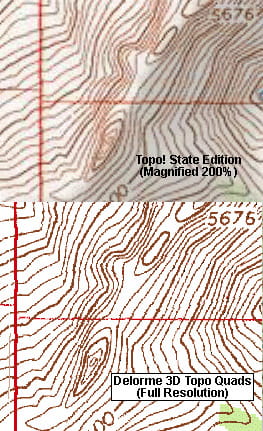 Topo State at 200% vs. Full Resolution
|
| Back to top |
|
|
Sore Feet
Member
Joined: 16 Dec 2001
Posts: 6306 | TRs | Pics
Location: Out There, Somewhere |
Certainly a valid observation. I just count the 200 foot contours when the 40 foot contours are too messy. I don't like Delormes because they didn't antialias the maps as they were scanned, so if you're not at full resolution, it's a bit crusty (the versions I've had in the past at least - maybe newer versions are cleaner). Especially bad were the older maps (the previous edition of Quartz Creek Butte 7", and Termination Point 7" comes to mind) To each his own though...
|
| Back to top |
|
|
|
|
You cannot post new topics in this forum
You cannot reply to topics in this forum
You cannot edit your posts in this forum
You cannot delete your posts in this forum
You cannot vote in polls in this forum
|
Disclosure: As an Amazon Associate NWHikers.net earns from qualifying purchases when you use our link(s). |


