| Previous :: Next Topic |
| Author |
Message |
Slugman
Its a Slugfest!


Joined: 27 Mar 2003
Posts: 16874 | TRs | Pics
|
|
Slugman
Its a Slugfest!
|
 Wed May 31, 2006 11:41 pm |
|
|
Daisy and I awoke at our car camp site on FS 2880, with nothing but blue skies above and a sweet breeze all around us, nice and rested up from our hike of the Gray Wolf the day before. We proceeded to do nothing at all from 9 am to noon, except let our gear dry out in the sun. That's the life!
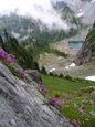
But eventually the desire to hike won out over sloth, so we drove over to the Tubal Cain mine TH and started out at 1:30 pm. I fell in love with this trail. It is so smooth, so nicely graded, a joy to walk on, and no switchbacks. The trail is in absolutely perfect condition. There is plenty to see as well. Some of the best moss gardens around, a fair amount of really big trees, burned-over areas making a comeback, and in a couple of weeks (?) a rhododendron flower show that promises to be spectacular, judging by all the immature buds on the gazillions of rhody bushes that line the trail for the first few miles.
At three miles the first mine is reached, just a couple of dozen feet up the Tull canyon side trail. A few flash pics and we were off again, soon arriving at the Tubal Cain area. Did I mention the moss? It is at its best in this area, copious in quantity and breathtaking in the vibrancy of its green color. I really enjoyed poking around the old mine debris and abandoned implements. There is a real feeling of history about the area. We then clambered up the tailings pile to the mine itself, a super-cool and spooky place. I especailly liked the stream flowing right out of the mine shaft. From that area we could see that the entire hillside that the trail switchbacks up after crossing Copper creek was all melted out. My guess is the trail is snow-free all or most of the way to Buckhorn pass. We were above 4,200 ft, and the snow level was about two thousand feet higher still, I'm guessing.
Our turn-around time was 6:15, and we took off then, reluctantly, because the last ferry out of Kingston at 11:10 pm won't wait no matter how many times I ask them to!  We got back to the car at 8:15, left at 8:30, made the QFC gas station in Sequim by 9:30 for a couple of "emergency gallons", still had time to fill 'er up at the Kingston Arco station ($2.99.9 for unleaded regular), and made the last ferry no problem. We rolled in to the driveway at midnight, exhausted but happy. Here are a bunch of the pics: We got back to the car at 8:15, left at 8:30, made the QFC gas station in Sequim by 9:30 for a couple of "emergency gallons", still had time to fill 'er up at the Kingston Arco station ($2.99.9 for unleaded regular), and made the last ferry no problem. We rolled in to the driveway at midnight, exhausted but happy. Here are a bunch of the pics:
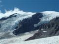
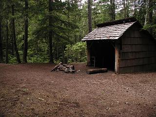 Silver shelter 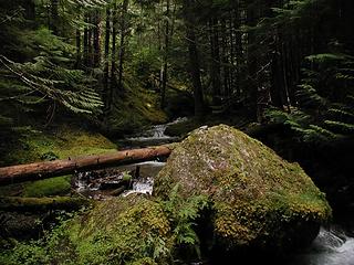 Silver creek 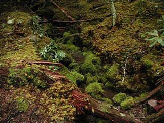 Mossy stream 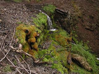 Mossy logs 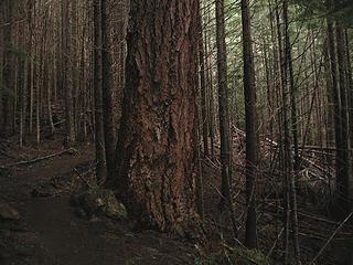 Man amongst boys 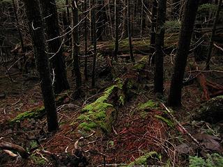 contrast in color 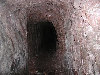 Tull canyon trail mine 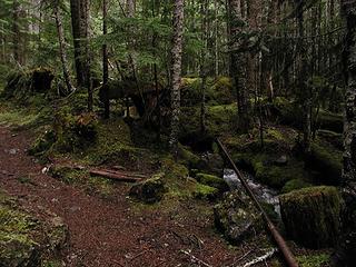 mossy trail 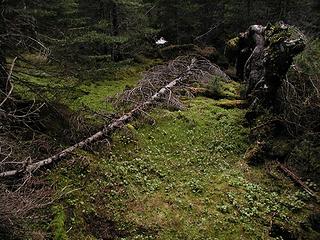 dead tree and moss 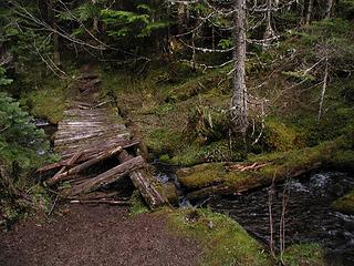 old puncheon 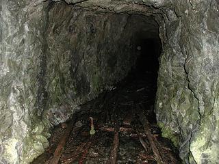 Tubal Cain mine 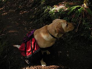 Daisy TWD 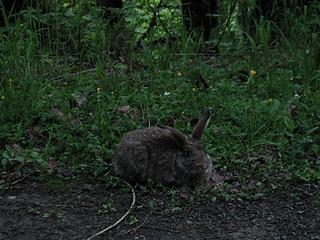 Who says you don't see critters when with a dog?
|
| Back to top |
  
|
|
summithound
Climbing Connoisseur
Joined: 26 Jul 2004
Posts: 1766 | TRs | Pics
Location: Everett, WA |
|
summithound
Climbing Connoisseur
|
Thu Jun 01, 2006 8:04 am |
|
|
Thanks for the trail report Slug. I've hiked the Tubal Cain Mine Trail before but couldn't figure out how to get to the actual Tubal Cain Mine entrance. Is it off the trail somewhere?
Pain is just weakness leaving the body.
Pain is just weakness leaving the body.
|
| Back to top |
|
|
Slugman
Its a Slugfest!

Joined: 27 Mar 2003
Posts: 16874 | TRs | Pics
|
|
Slugman
Its a Slugfest!
|
Thu Jun 01, 2006 8:17 am |
|
|
Just a bit off the trail. Very shortly before the crossing of Copper creek, look for a way trail off to the left, currently marked with a bit of flagging tape, but fairly obvious without it. You will come right away to a couple of large campsites littered with old boilers and other mining detritus too big to be carried off by souvenier hunters. Cross over the small stream by one of the bootpaths and head over towards the cliffs. You will see a huge mine tailings pile, so big you might think it was a natural talus fan, at least 100 ft tall and steeply-sloped. There is a rude path along the left side of the pile, which crosses over to the right side near the top of the pile, which then brings you to the cliff face a hundred or so feet above the campsites, and the site of the mine entrance, which you can't miss once you get up the tailings pile. I found it with just the info that it was at the top of the pile, so you should have no problem with the above directions. It's well worth finding, IMO.
|
| Back to top |
|
|
Hiker Boy
Hinking Fool

Joined: 18 Feb 2002
Posts: 1569 | TRs | Pics
Location: Northern Polar Icecap |
|
Hiker Boy
Hinking Fool
|
Thu Jun 01, 2006 8:47 am |
|
|
Wow, very cool looking area. I love poking around old mines as well.
|
| Back to top |
|
|
captain jack
Serving suggestion

Joined: 25 May 2004
Posts: 3389 | TRs | Pics
Location: Upper Fidalgo |
| Slugman wrote: | | still had time to fill 'er up at the Kingston Arco station ($2.99.9 for unleaded regular) |
 My "go to " gas station on the peninsula, always cheaper than the Seattle side.
I paid the same $2.99 a gallon at the Arco in Yakima on sunday.
My "go to " gas station on the peninsula, always cheaper than the Seattle side.
I paid the same $2.99 a gallon at the Arco in Yakima on sunday.  With todays prices we need a cheap gas station referral list in here.
Anybody else with good deals on gas?
With todays prices we need a cheap gas station referral list in here.
Anybody else with good deals on gas?
|
| Back to top |
|
|
Jeff R
Closet hiker.
Joined: 10 Apr 2005
Posts: 972 | TRs | Pics
Location: Everret |
|
Jeff R
Closet hiker.
|
Thu Jun 01, 2006 8:23 pm |
|
|
Nice report and pictures Slugman!
So what did you think of the 20+ miles of forest road to get to the trail head?
|
| Back to top |
|
|
Slugman
Its a Slugfest!

Joined: 27 Mar 2003
Posts: 16874 | TRs | Pics
|
|
Slugman
Its a Slugfest!
|
Fri Jun 02, 2006 8:37 am |
|
|
It's so-so. There's lots of ups then downs, the car gaining a vertical mile (seemingly) to get to a 3,000 ft trailhead from sea level. The part down to Dungeness Forks campground is super-steep and windy, and pretty darn narrow in places. Potholes are not very plentiful, mainly the road is decent, but when you do come to some potholes, slow down bigtime, because the ones that are there are clustered too tightly to get around by swerving, and are very deep. But most of them are in one stretch of under a mile. It took me almost 45 minutes to drive from the Tubal Cain TH to the junction of Palo Alto rd and Hiway 101, and I wasn't dawdling along, either, with a ferry to catch.
|
| Back to top |
|
|
Jeff R
Closet hiker.

Joined: 10 Apr 2005
Posts: 972 | TRs | Pics
Location: Everret |
|
Jeff R
Closet hiker.
|
Fri Jun 02, 2006 8:59 pm |
|
|
I thought the road was neat, really enjoyed it at the time. It just seemed nicely graded, maybe it has detiorated since then.
Did you know about the plane wreckage in Tull Canyon before the Creek crossing and mine area? There is not much plane left but its not to far from the main trail, worth checking out. The 15 foot tall rhodies alongside the trail are spectacular.
|
| Back to top |
|
|
justybug
henteaser

Joined: 12 Jun 2005
Posts: 300 | TRs | Pics
Location: wobbly in the heather.. |
|
justybug
henteaser
|
Fri Jun 02, 2006 11:15 pm |
|
|
i like that road, but those potholes are no joke! nice pics slugman!
kenya believe it??
"Time is so everything doesn't happen at once. Space is so everything doesn't happen to you."
kenya believe it??
"Time is so everything doesn't happen at once. Space is so everything doesn't happen to you."
|
| Back to top |
|
|
Slugman
Its a Slugfest!

Joined: 27 Mar 2003
Posts: 16874 | TRs | Pics
|
|
Slugman
Its a Slugfest!
|
Sat Jun 03, 2006 8:23 am |
|
|
The road has its good points. Some people like windy roads, and there are a few nice view sections, plus the typical spots to see rushing rivers, etc. I'm just not a big fan of driving on dirt roads, and that one is fairly long, is all. For most of the way I was able to cruise at speeds approaching 30 mph.
Jeff: I did know about the plane wreckage, but with my 1:30 start, it just wasn't on the agenda that day.
|
| Back to top |
|
|
|
|
You cannot post new topics in this forum
You cannot reply to topics in this forum
You cannot edit your posts in this forum
You cannot delete your posts in this forum
You cannot vote in polls in this forum
|
Disclosure: As an Amazon Associate NWHikers.net earns from qualifying purchases when you use our link(s). |


