| Previous :: Next Topic |
| Author |
Message |
ridgewalker
Mountains and Rivers


Joined: 19 Aug 2003
Posts: 223 | TRs | Pics
Location: North Bend |
|
ridgewalker
Mountains and Rivers
|
 Mon Nov 06, 2006 7:15 pm |
|
|
LONG TERM...HAVE NOT HAD AN ENORMOUS AMOUNT OF TIME TO LOOK AT THE EXTENDED. BUT IT APPEARS ANOTHER SYSTEM MOVES INTO WASHINGTON THURSDAY NIGHT...WITH PRECIPITATION LIKELY AT TIMES THROUGH THE WEEKEND. SNOW LEVELS DROP WAY DOWN...1000 FEET OR SO BY MONDAY. COOL AND SNOWY RATHER THAN WARM AND FLOODY.
Haven't seen this since Oct 2003, when last hit this forcast. The key is that there was that earlier rain and no wind. The Freezing level is 10,000 in the cascades, yet I saw snow at the 3000 ft level in the olympics this weekend. In the end, with the cold, it means some damage to instable fire slopes... But after that... maybe we will be able to slowly get a accumulations. We'll see. Break out the Mud/Snowshoes...
-- Ridgewalker
Back from the Crest
|
| Back to top |
  
|
|
Dave Workman
Member

Joined: 06 Aug 2006
Posts: 3699 | TRs | Pics
Location: In the woods, by the big tree |
I am surrounded by rain, and I believe I just saw a run of salmon in my driveway. Well, not really, because salmon can't get above Snoqualmie Falls no matter how much water is pouring down and how strong they swim against the current..
There seems to be a break in the storm but I don't know for how long. So, I sit here working on a big writing project, munching on a fresh baked chocolate chip cookie, and keep my eye on Northwest Cable News. Presently, I will fire up the scanner to see where the cops are having the most "fun" and that is about all one can do.
I have no idea whether North Bend will be cut off by morning, as this is about the worst I've seen since about 1975, and that was a doozy.
Fortunately, we've got plenty of food, and I don't have to worry about drinking water because it is pouring from the sky in buckets. This is a good night for working, provided power stays up. So far, so good.  Ah to wish for summer, and a calm trek amid the high peaks....
glub...glub....glub
Ah to wish for summer, and a calm trek amid the high peaks....
glub...glub....glub
"The essential American soul is hard, isolate, stoic, and a killer. It has never yet melted." - D.H. Lawrence
"The essential American soul is hard, isolate, stoic, and a killer. It has never yet melted." - D.H. Lawrence
|
| Back to top |
|
|
Sore Feet
Member

Joined: 16 Dec 2001
Posts: 6307 | TRs | Pics
Location: Out There, Somewhere |
| MtnGoat wrote: | | I guess that means you need to hit Sunset and Eagle Falls along with Snoqualmie. Your honor depends on it. |
Wish I could, roads are closed though. Eagle Falls wouldn't be anything worth seeing - it just becomes a long stretch of froth. Probably totally indistinguishable from the rest of the river at this point. Sunset Falls, however, could be interesting.
|
| Back to top |
|
|
Justan
Member
Joined: 04 Oct 2004
Posts: 1041 | TRs | Pics
|
|
Justan
Member
|
Mon Nov 06, 2006 11:47 pm |
|
|
| Dave Workman wrote: | | I am surrounded by rain, and I believe I just saw a run of salmon in my driveway. Well, not really, because salmon can't get above Snoqualmie Falls no matter how much water is pouring down and how strong they swim against the current..
glub...glub....glub |
 They're coming...
This image was snagged from the Seattle Times a few years ago. IIRC it was taken a few miles below the falls.... They're coming...
This image was snagged from the Seattle Times a few years ago. IIRC it was taken a few miles below the falls....
|
| Back to top |
|
|
aestivate
Member

Joined: 19 Mar 2004
Posts: 199 | TRs | Pics
|
| MtnGoat wrote: | | Looks like the Pac NW is getting hammered with some record high rainfall...how will this affect areas already considered for repair of washouts from seasons past? Will new studies be required, will new washouts mean reconsideration of fixing previous ones? |
The Sauk above Whitechuck gauge peaked at about 34K today. In 2003 I think it was up to 44. The same general ratio prevails at the lower Sauk gauge (below where the Whitechuck and Suiattle join). So I'm guessing--only guessing, mind--that there won't be a lot of additional damage to the 2003 sites along the Mt Loop and Suiattle. Merely a "third highest recorded flow"
But the Skykomish easily hit a new record, and the Mid Fork did, barely. And what about the S Fk stilly? Seems pretty bad. So I reckon there will be a lot of damage to the road system elsewhere.
|
| Back to top |
|
|
silence
Member

Joined: 25 Apr 2005
Posts: 4420 | TRs | Pics
|
|
silence
Member
|
Tue Nov 07, 2006 12:25 pm |
|
|
From Mike Gauthier's (lead climbing ranger at Mt Rainier) blog:
No, it's REALLY raining up here
The southside of the park is closed; the rain has started to washout or significantly threaten a number of roads and access points. For updated information about weather and access, call 360 569 2211 and press ext 9.
Updates: the weather observations for Paradise measured 11.3 inches in the past 24 hours! At Camp Muir, the temps hovered in the mid 30's (probably rain) but it was the wind speed that remained impressive. Gust of 121 MPH were recorded and the average wind speed was 101!!
The Nisqually River (pictured right) is nothing short of boiling chocolately torrent (as is every other creek and stream around here). The river sounds like a freight train and the ground trembles as large boulders and old growth trees jostle into the flow. The air even smells of glacial mud, cedar and pine.
As it stands now, the NPS is evacuating any non-essential personnel from the park before the roads completely washout. The Carbon River road is also closed, as is the rest of the park.
-- posted by Mike Gauthier at Monday, November 06, 2006
PHOTOS
FILMS
Keep a good head and always carry a light bulb. Bob Dylan
PHOTOS
FILMS
Keep a good head and always carry a light bulb. Bob Dylan
|
| Back to top |
|
|
MCaver
Founder

Joined: 14 Dec 2001
Posts: 5124 | TRs | Pics
|
|
MCaver
Founder
|
Tue Nov 07, 2006 1:09 pm |
|
|
From KING5: 11:57 a.m. The Lewis County sheriff's office says flooding has changed the course of the Cowlitz River at Packwood. Deputy Stacy Brown says 300 homes are threatened with flooding.
|
| Back to top |
|
|
Mtn Dog
Technohiker

Joined: 01 Aug 2004
Posts: 3336 | TRs | Pics
Location: Bellevue, WA |
|
Mtn Dog
Technohiker
|
Tue Nov 07, 2006 1:19 pm |
|
|
I was out in Fall City yesterday and took a bunch of photos for work. Here's Snoqualmie Falls before sunset Monday. I couldn't tell if I was getting wet from sideways blowing rain or from the spray of the falls or both!
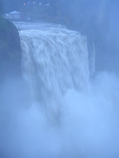 Heavy runoff at Snoqualmie Falls 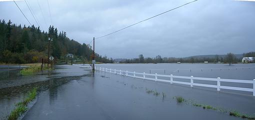 308th Ave SE from SR 202
Footprints on the sands of time will never be made sitting down.
Footprints on the sands of time will never be made sitting down.
|
| Back to top |
|
|
Quark
Niece of Alvy Moore

Joined: 15 May 2003
Posts: 14152 | TRs | Pics
|
|
Quark
Niece of Alvy Moore
|
Tue Nov 07, 2006 7:09 pm |
|
|
This flood incident will spur a whole barrage of repair issues in the NF, NP, and other public lands. Check the websites of land managers often - in a case like this, it's ok to ASSUME there will be public comment periods in the future, but no one will knock on your door, you have to make effort. Check land manger websites, check with Mountaineers publications, Washington Trails publications, sign up for online newsletters and emails from these organizations.
Don't forget!!!!
And if you miss out and don't participate, don't whine more than two times.
It's kinda cool, living amongst geomorphology, so long as you're not part of the morphology. Saw a trip report on WTA's site about some folks hiking back in the Mid Fk area thinking it was cool in all the rain - they were lucky they considered that roads could wash out, so left. Lucky for them the creek didn't rise higher on their return trip....
I heard it takes a few days for the water to filter down from the mtns. I'm itching to get out & see damage though.
"...Other than that, the post was more or less accurate."
Bernardo, NW Hikers' Bureau Chief of Reporting
"...Other than that, the post was more or less accurate."
Bernardo, NW Hikers' Bureau Chief of Reporting
|
| Back to top |
|
|
Quark
Niece of Alvy Moore
Joined: 15 May 2003
Posts: 14152 | TRs | Pics
|
|
Quark
Niece of Alvy Moore
|
Tue Nov 07, 2006 7:22 pm |
|
|
Most funding was approved within a year of the 2003 floods; it's the EIS and other democratic processes that take so long. Negotiations with other users, negotiations with those not agreeing to repair, etc. The main issue isn't money for 2003 damage, never was (not for long, at least).
Public comment periods will begin shortly after the damage is assessed. In 2003, I think the public comments for the White Chuck and the Suiattle bridges started early 2004.
My reminder about it was prompted by the surprise of so many people that there was a public comment period for Barlow Pass area, etc., and were aghast that the comment period was over, and the repair processes were underway. The thread went on for pages and pages and pages, while the point was moot. The claim was "gee, we didn't know the plans."
Well - here's a heads up: There will be damage. Where there's damage, there's public comment. Let's try to eliminate the surprises this time.
"...Other than that, the post was more or less accurate."
Bernardo, NW Hikers' Bureau Chief of Reporting
"...Other than that, the post was more or less accurate."
Bernardo, NW Hikers' Bureau Chief of Reporting
|
| Back to top |
|
|
Quark
Niece of Alvy Moore
Joined: 15 May 2003
Posts: 14152 | TRs | Pics
|
|
Quark
Niece of Alvy Moore
|
Tue Nov 07, 2006 7:31 pm |
|
|
Yup, I will make every effort to open my big mouth where it can do some good. Sometimes the advocacy groups do the job for us - but if we disagree with what they're advocating, we should speak up at that time, not after the fact at which point it's just irritating noise.
"...Other than that, the post was more or less accurate."
Bernardo, NW Hikers' Bureau Chief of Reporting
"...Other than that, the post was more or less accurate."
Bernardo, NW Hikers' Bureau Chief of Reporting
|
| Back to top |
|
|
naturealbeing
Member

Joined: 05 Dec 2004
Posts: 1565 | TRs | Pics
Location: Great Mystery |
Was up at Granite Falls today and used my camera to capture some video. Mind you, this is a camera and it's not really designed for great video and when you compound it with the compression needed to reduce bandwith, well...this is what you get. At least it has some entertaining value, as the fish ladder is being plummeted with tons of water.
Here's some stills from this afternoon.
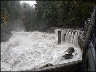 Granite Falls Fish Ladder 11.7.06 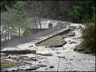 Granite Falls Fish Ladder 11.7.06 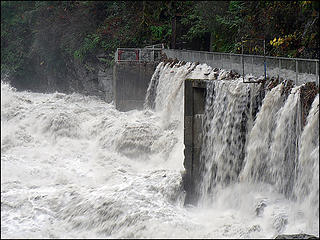 Granite Falls Fish Ladder 11.7.06 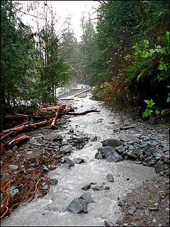 Road Leading To Granite Falls Fish Ladder 11.7.06
|
| Back to top |
|
|
Dslayer
Member
Joined: 02 Jan 2002
Posts: 652 | TRs | Pics
Location: Home: Selah Work: Zillah |
|
Dslayer
Member
|
Tue Nov 07, 2006 7:48 pm |
|
|
If you go to NWCN.com, click on the story titled Rising Washington Rivers Force Evacuations, you'll find a picture of a house being swept down the Cowlitz R. That's about a 1/4 mile from a little cabin that's been in the Dslayer family for 30 plus years-2 others have gone downriver. So far our place is safe, but word is now that a big log jam upriver may or may not let go, and if it does all hell will break loose.
"The Second Amendment of the Bill of Rights is my concealed weapon permit."-Ted Nugent
"The Second Amendment of the Bill of Rights is my concealed weapon permit."-Ted Nugent
|
| Back to top |
|
|
Sore Feet
Member
Joined: 16 Dec 2001
Posts: 6307 | TRs | Pics
Location: Out There, Somewhere |
Eagle Falls from the Times website:
|
| Back to top |
|
|
Allison
Feckless Swooner

Joined: 17 Dec 2001
Posts: 12287 | TRs | Pics
Location: putting on my Nikes before the comet comes |
|
Allison
Feckless Swooner
|
Tue Nov 07, 2006 8:47 pm |
|
|
Has anyone heard from my mom? 
www.allisonoutside.com
follow me on Twitter! @AllisonLWoods
www.allisonoutside.com
follow me on Twitter! @AllisonLWoods
|
| Back to top |
|
|
|
|
You cannot post new topics in this forum
You cannot reply to topics in this forum
You cannot edit your posts in this forum
You cannot delete your posts in this forum
You cannot vote in polls in this forum
|
Disclosure: As an Amazon Associate NWHikers.net earns from qualifying purchases when you use our link(s). |


