| Previous :: Next Topic |
| Author |
Message |
Ancient Ambler
Member


Joined: 15 May 2007
Posts: 1092 | TRs | Pics
Location: Bainbridge Island |
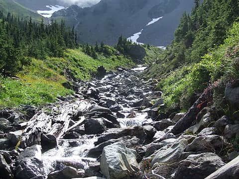
Any way you cut it, it's a long way in to LaCrosse Basin, but it is one of the most scenic areas of the Olympics, as demonstrated in the photo of Hart Lake and Mount Duckabush gracing the cover of the third edition of Wood's Olympic Mountains Trail Guide. So with my son in town from the far north for enough days to get to LaCrosse and back, decided to head in there via the Dosewallips, Anderson Pass, O'Neill Pass trails, except taking the short cut over Fisher's Notch where the O'Neill Pass trail crosses White Creek.
Having been rained out of the Cascades the week before by an intense storm on a hike with my daughter, I kept a close watch on the weather forecasts. While the weather was not looking ideal, at least partly sunny skies were forecast for Tuesday. Some rain was possible Wednesday, but as of early Monday morning when we left, it did not sound like strong weather systems were aimed at the Olympics during the days we would be there.
Hadn't been up the Dose since the road washout and found the 5.5 mile road walk to be not as annoying as I had feared. (btw, it's pronounced doe-see, for those not familiar with that). There are definitely places where the forest is closing in on the road and it has more of the feeling of a trail. Pounded out the approximately 14 miles to Honeymoon Meadows, appreciating the excellent work done by an ONP trail crew who had their camp site at Diamond Meadows. Lots of avalanche jackstrawed trees cut away from the trail, lots of rock placement and trail bed restoration, plus a big bonus was extensive removal of brush along the trail so it was possible to proceed without brush transferring gallons of beaded water onto your clothing. Skies were generally gray, and the rain started about the time we reached Honeymoon Meadows camp, in the trees on the south side of the West Fork of the Dose, whereas the actual meadow in on the north side of the river. We were the only ones there at first, and were able to get one of the few tent sites that wouldn't turn into a mud puddle in a heavy rain. A couple arrived later.
Tuesday August 26 broke clear and cold, giving us hope that the weather forecast for decent weather that day would hold. We did the easy, calf-deep ford of the West Fork.
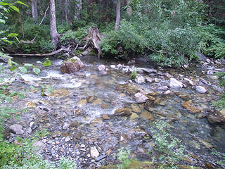 ford across the West Fork at Honeymoon Meadows 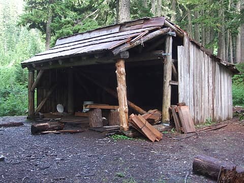 Camp Siberia 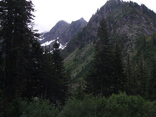 on the trail uphill from Camp Siberia 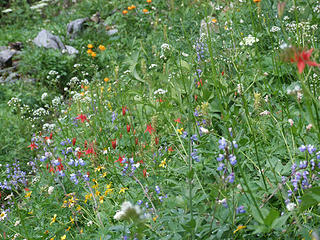 late wild flowers, meadows uphill from Camp Siberia 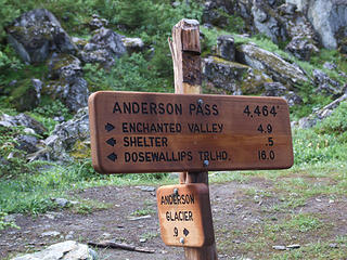 Anderson Pass trail signs 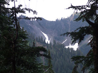 1 label View of Fisher's Notch from west side of Anderson Pass 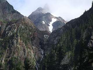 waterfall off of Anderson, from west side of Anderson Pass 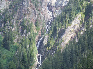 waterfall off of Anderson 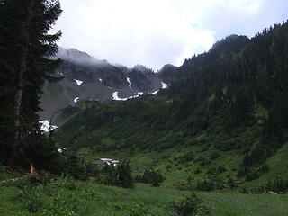 nearing White Creek meadows 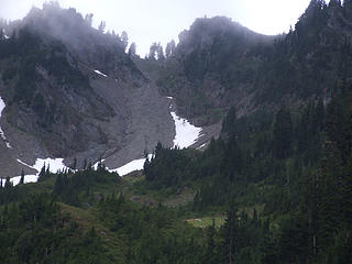 1 label zoom shot of Fisher's Notch from White Creek meadows 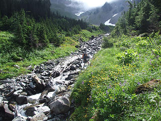 son crossing White Creek 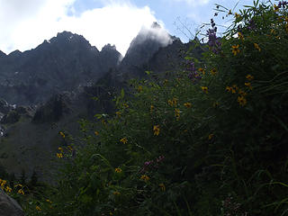 peaks west of White Mountain 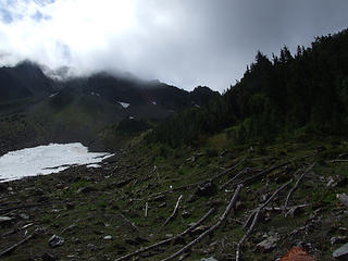 1 label route up toward Fisher's Notch past White Creek 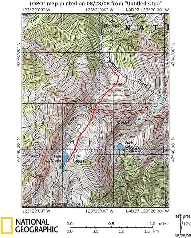 fisher's notch route topo 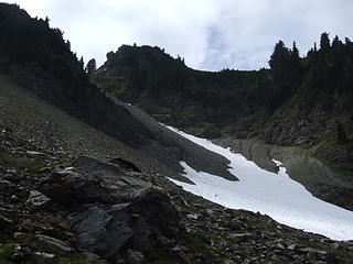 1 label upper basin below Fisher's Notch 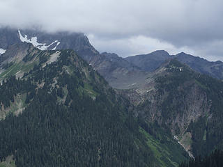 Anderson socked in, Diamond Peak in background 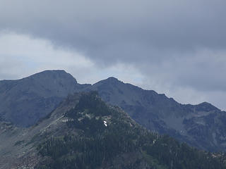 Diamond Peak 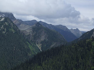 Anderson Pass from route up Fisher's Notch 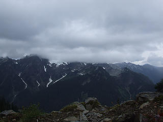 View N from Fisher's Notch, weather socking in 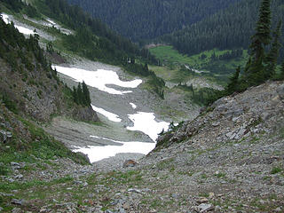 1 label View N toward White Creek Meadow from top of Fisher's Notch 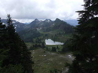 LaCrosse Basin and Lake LaCrosse from Fisher's Notch 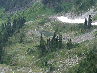 Tarn NW of Lake LaCrosse 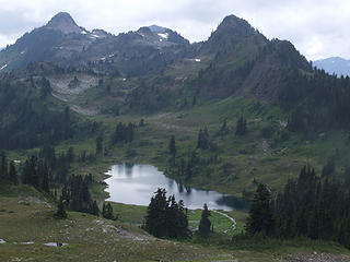 LaCrosse basin heading down from Fisher's Notch 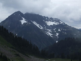 Mount Duckabush 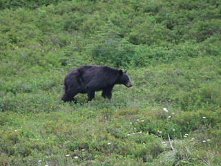 Bear ignoring us 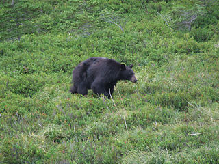 Bear about 40 feet away northbound 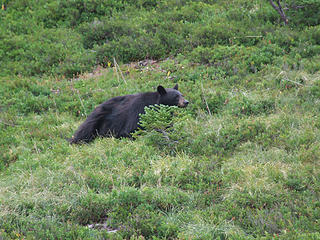 Bear travelling north while we're heading south 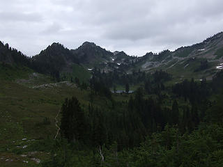 Looking N toward Lake LaCrosse and Fisher's Notch 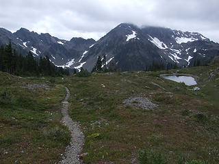 Nearing turnoff to Hart Lake 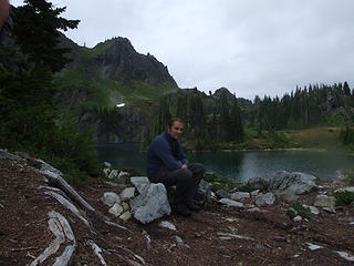 Son at Hart Lake 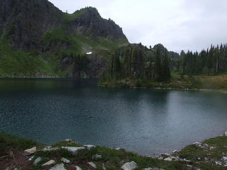 Hart Lake 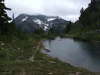 Hart Lake, Mt. Duckabush 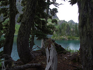 Hart Lake 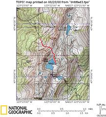 hart lake way trail topo 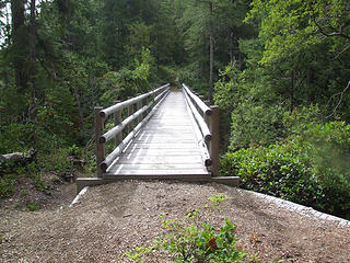 bridge over the West Fork 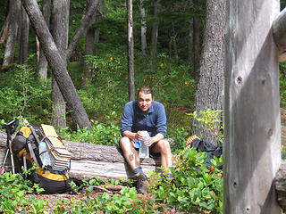 taking a break on the way out 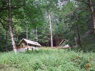 Dose ranger station 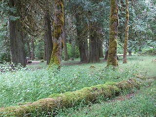 languishing Dose campground 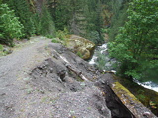 Dose road erosion near the cascades 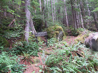 start of Constance Lake trail 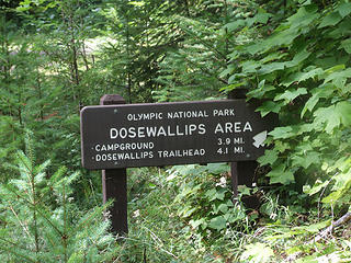 Sign near Elkhorn camp 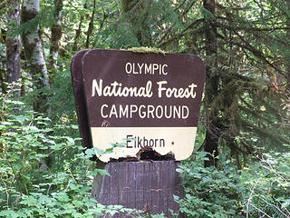 deteriorating Forest Service sign 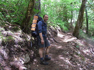 Final uphill on the "up and over" trail near road end 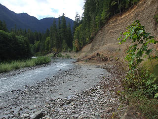 Dose road washout  Trail's end, or beginning
|
| Back to top |
  
|
|
Dayhike Mike
Bad MFKer
Joined: 02 Mar 2003
Posts: 10958 | TRs | Pics
Location: Going to Tukwila |
 Nice trip...
I've also looked at the pass NNE of Buck Lake and wondered if it was a passable route to get over from the White Creek drainage.
Anyone know if it goes? Sure looks doable on the Topo... Nice trip...
I've also looked at the pass NNE of Buck Lake and wondered if it was a passable route to get over from the White Creek drainage.
Anyone know if it goes? Sure looks doable on the Topo...
"There is only one basic human right, the right to do as you damn well please. And with it comes the only basic human duty, the duty to take the consequences." -P.J. O'Rourke
"Ignorance is natural. Stupidity takes commitment." -Solomon Short
"There is only one basic human right, the right to do as you damn well please. And with it comes the only basic human duty, the duty to take the consequences." -P.J. O'Rourke
"Ignorance is natural. Stupidity takes commitment." -Solomon Short
|
| Back to top |
|
|
gone
Member

Joined: 08 Feb 2008
Posts: 1051 | TRs | Pics
|
|
gone
Member
|
 Fri Aug 29, 2008 4:59 pm |
|
|
Fantastic trip, report, and pics! Well done!
|
| Back to top |
|
|
goats gone wild
Mr. Goat

Joined: 19 Aug 2007
Posts: 2524 | TRs | Pics
Location: Vampireville |
.....leaving me wanting to return over and over in what ever capacity that may be, even if one day my knees are too old and I can only see the mountains from my porch.
Jason Hummel
|
| Back to top |
|
|
bobbi
stillaGUAMish

Joined: 13 Jul 2006
Posts: 8012 | TRs | Pics
Location: olympics! |
|
bobbi
stillaGUAMish
|
Fri Aug 29, 2008 7:12 pm |
|
|
bobbi ૐ
"Today is your day! Your mountain is waiting. So
get on your way!" - Oh, the Places Youll Go! By Dr. Seuss
|
| Back to top |
|
|
Flower Sniffer
Sniffer of flowers

Joined: 12 Jun 2006
Posts: 977 | TRs | Pics
Location: Snohomish, WA |
What a wild week! We saw 26 bears, 50 elk, hawks, chipmunks, squirrels, black beetles, frogs, fish, and these guys....
 It was a pleasure meeting you and your son Ancient Ambler! We'd be happy to hike with you anytime. What an amazing trip. We finally saw our elk in the woods along the Quinault. There were about 50 of them laying about 50 feet off the trail. They were so beautiful! Anyway, glad to see you made it home safely.
If you don't know where you're going, any road will take you there.
If you don't know where you're going, any road will take you there.
|
| Back to top |
|
|
Bloated Chipmunk
Cock Rock Searcher

Joined: 29 Jan 2007
Posts: 2993 | TRs | Pics
Location: Margaritaville |
| Flower Sniffer wrote: | | We saw 26 bears, |
WTF?!  That's crazy! Lucky you. Now I know where to go to see lots-o-wildlife... That's crazy! Lucky you. Now I know where to go to see lots-o-wildlife...
Home is where the hiking is.
"Peaks that have come and gone four times should halt a man in his steps." -- William O. Douglas
A balanced diet is a margarita in each hand.
Home is where the hiking is.
"Peaks that have come and gone four times should halt a man in his steps." -- William O. Douglas
A balanced diet is a margarita in each hand.
|
| Back to top |
|
|
ScottM
Member

Joined: 18 Apr 2007
Posts: 363 | TRs | Pics
Location: The Olympics |
|
ScottM
Member
|
Fri Aug 29, 2008 9:13 pm |
|
|
Ancient Ambler, I always look for your trip reports because they do not disappoint. Too bad about the weather but it looks like you had a decent trip anyway. Can you believe it's August. Lost power in Port Angeles today. A tree blew over and took out a power line.
|
| Back to top |
|
|
bobbi
stillaGUAMish
Joined: 13 Jul 2006
Posts: 8012 | TRs | Pics
Location: olympics! |
|
bobbi
stillaGUAMish
|
Fri Aug 29, 2008 9:18 pm |
|
|
so that's what happened as i am in port angeles, too! thanks for the info, ScottM!
bobbi ૐ
"Today is your day! Your mountain is waiting. So
get on your way!" - Oh, the Places Youll Go! By Dr. Seuss
bobbi ૐ
"Today is your day! Your mountain is waiting. So
get on your way!" - Oh, the Places Youll Go! By Dr. Seuss
|
| Back to top |
|
|
Ancient Ambler
Member
Joined: 15 May 2007
Posts: 1092 | TRs | Pics
Location: Bainbridge Island |
Thanks for the kind comments, all. Have been away from the computer since submitting the TR yesterday.
DHM: I was hoping for good weather in LaCrosse Basin on Wedenesday so we could go up to Buck Lake and then on to the smaller Pocket Lake above Buck and climb White Mountain to scope out the high traverse over to LaCrosse pass. Route 3 in the Climbers Guide has one drop down from Pocket Lake to the north side of the small glacier and then head east from there up to the summit of White. It's rated as class 2 up to White using this route. I don't see why a person couldn't ascend up the White Creek drainage to the notch just above Pocket Lake and then head in that way, but clouds veiled this area when we were ascending Fisher's Notch, so I can't be sure. You should be able to get an idea about the lower portions of your desired route from the following photos:
 view toward headwaters of White Creek 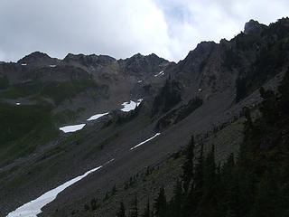 White Mountain from route up Fisher's Notch 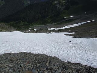 snow slope below Fisher's Notch
|
| Back to top |
|
|
reststep
Member
Joined: 17 Dec 2001
Posts: 4757 | TRs | Pics
|
|
reststep
Member
|
Sat Aug 30, 2008 4:10 pm |
|
|
I really enoyed your report AA.
Edit: and thanks for the pictures of Fisher's Notch. That sure would be a much shorter route than taking the trail that winds around on the side of the ridge.
That wind tuesday night must have been state wide. We were camped in the Enchantments that night and the wind was going through there like a freight train all night and the next day. I was not sure the tent was going to survive but it did.
"The mountains are calling and I must go." - John Muir
"The mountains are calling and I must go." - John Muir
|
| Back to top |
|
|
Mark Griffith
(Embrace yourself)

Joined: 14 Mar 2005
Posts: 853 | TRs | Pics
Location: Issaquah |
Great trip report! Ever since seeing photos of that region its been "on my list", thanks for the great info on some additional ways in and out of the region.
|
| Back to top |
|
|
rpgoldsmith
Member
Joined: 18 Aug 2006
Posts: 3 | TRs | Pics
|
Did this in early Sept. I hadn't seen your post. Glorious weather, but small wildlife (I bear close up, 1 elk bugler) Will post pix when I get free time
|
| Back to top |
|
|
Pliny
Member

Joined: 30 Jan 2004
Posts: 20 | TRs | Pics
|
|
Pliny
Member
|
Sat Apr 01, 2017 11:39 am |
|
|
A couple of us old guys (very experienced, but getting older and slower) are planning a trip up the Dose and out the Duck and doing the Fisher's Notch in the process. Thanks for you pictures and description. This sort of thing makes the internet valuable. One of the few things I think sometimes. Pliny
|
| Back to top |
|
|
RodF
Member

Joined: 01 Sep 2007
Posts: 2593 | TRs | Pics
Location: Sequim WA |
|
RodF
Member
|
Sat Apr 01, 2017 1:56 pm |
|
|
Pliny, be aware the Duckabush Trail has not been cleared since 2014 and has three winters accumulation of windfall trees down across it. Park Trail Conditions reports "90 trees down between Ten-Mile Camp and Upper Duckabush, 10/26/16". The total number of windfall above the Park boundary is likely double that number or more. This will make it slow going.
A cluster of windfall just below 5 Mile Camp blocked stock access for the past two years, so Park trail crews were unable to get into the Duck. USFS finally cleared this cluster late last fall. Hopefully the Park may be able to clear the Duck sometime in the 2017 work season.
"of all the paths you take in life, make sure a few of them are dirt" - John Muir
"the wild is not the opposite of cultivated. It is the opposite of the captivated - Vandana Shiva
"of all the paths you take in life, make sure a few of them are dirt" - John Muir
"the wild is not the opposite of cultivated. It is the opposite of the captivated - Vandana Shiva
|
| Back to top |
|
|
|
|
You cannot post new topics in this forum
You cannot reply to topics in this forum
You cannot edit your posts in this forum
You cannot delete your posts in this forum
You cannot vote in polls in this forum
|
Disclosure: As an Amazon Associate NWHikers.net earns from qualifying purchases when you use our link(s). |


 I am curious to see if anyone knows the answer to DHM question. We wondered the same thing when we were last at LaCrosse.
I imagine you
I am curious to see if anyone knows the answer to DHM question. We wondered the same thing when we were last at LaCrosse.
I imagine you 
 Good you ran into HJT, too. He was going to do his trip solo and then his dad offered to meet up with him. I was thinking his dad must be in great shape to do the route HJT had planned out. KUDOs for that!
Thanks again for the great TR.
Good you ran into HJT, too. He was going to do his trip solo and then his dad offered to meet up with him. I was thinking his dad must be in great shape to do the route HJT had planned out. KUDOs for that!
Thanks again for the great TR.  that was some nasty rain tuesday evening.
my buddies and i hiked the heather park trail to lake angeles trail then out on tuesday. great 12+ mile loop.
that was some nasty rain tuesday evening.
my buddies and i hiked the heather park trail to lake angeles trail then out on tuesday. great 12+ mile loop.  i can only imagine what you and your son had to endure that evening of wind and rain. glad to hear that your tent/sleeping bags survived, too.


