| Previous :: Next Topic |
| Author |
Message |
Sultan Guy
Member


Joined: 22 Jul 2008
Posts: 353 | TRs | Pics
Location: Now reinforced with Concrete |
As some of you who hike in the Spada basin have heard there will be a new hiking trail built to access the Sultan River gorge below Culmback Dam. This trail is being paid for by the PUD as part of the settlement agreement reached under terms of their new FERC license. This is for recreational mitigation and enhancement to tie into future planned recreational whitewater releases on this section of river.
The trail traverses USFS lands so the USFS is involved in selecting the route and planning although ultimately the PUD is responsible for contracting out the construction. The concept for this trail is multi purpose for both kayakers and hikers to experience a rare example of well preserved low elevation old growth forest on the west side of the Cascades. The planned route was recently flagged by a USFS trail specialist and I was invited along with other USFS staff, and PUD staff to review and comment on the proposed route.
A month ago June 10th sounded like a nice summer day, however in typical Sultan Basin fashion it was cold and WET  We had a cool experience just before Olney Pass while driving when someone spotted a mountain goat on a rocky bluff off of Blue Mountain.
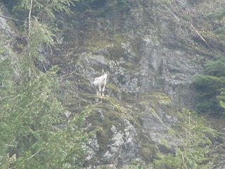 Mtn. Goat on Blue Mountain 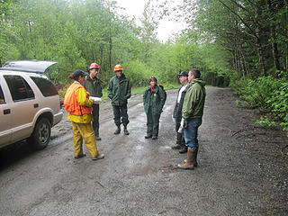 Pre hike meeting with USFS and SNOPUD staff 
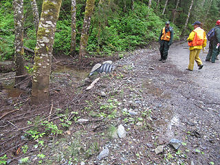 Discussing culverts 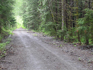 Start of trail 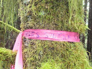 USFS Sultan River Trail 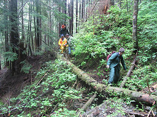 The non steep section 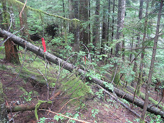 Try and visualize a nice trail 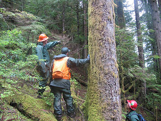 USFS discussing Marbled Murrelet nesting habitat 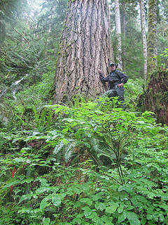 SG with a HUGE old growth tree 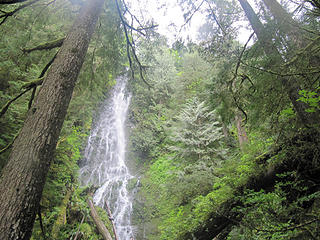 200 foot waterfall 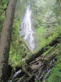 018 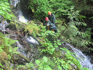 One of several tough creek crossings 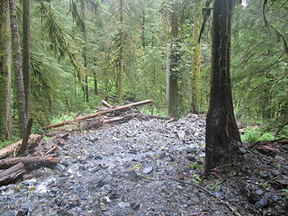 028 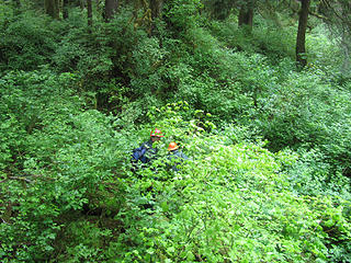 Thrashing thru the brush, good thing they have hard hats 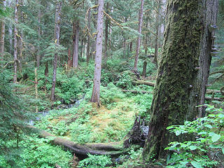 Lowland forest 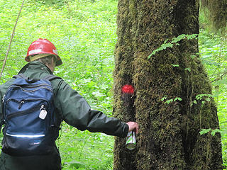 Marking trees 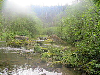 Sultan River
Any worthwhile expedition can be planned on the back of an envelope- H. W. Tilman
Any worthwhile expedition can be planned on the back of an envelope- H. W. Tilman
|
| Back to top |
  
|
|
Scrooge
Famous Grouse

Joined: 16 Dec 2001
Posts: 6966 | TRs | Pics
Location: wishful thinking |
|
Scrooge
Famous Grouse
|
 Fri Jun 11, 2010 8:56 am |
|
|
Something lost behind the ranges. Lost and waiting for you....... Go and find it. Go!
|
| Back to top |
|
|
Sultan Guy
Member
Joined: 22 Jul 2008
Posts: 353 | TRs | Pics
Location: Now reinforced with Concrete |
Good questions Scrooge.
There was two issues with continuing to use the old 6122 route.
Length and miners.
This new trail will be shorter then what has been traditionally used and will also avoid a troublesome miner who has really been raising stink with USFS and other public hikers/kayakers. That old 1872 mining law is the real deal!
Unfortunately for hikers wishing to see cool rapids, this new proposed trail reaches the Sultan River at a low river gradient section in between two canyons of rapids. Here are some other pictures of what it looks like just upstream, like only a quarter mile.
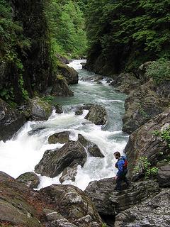 Top of canyon exit rapid 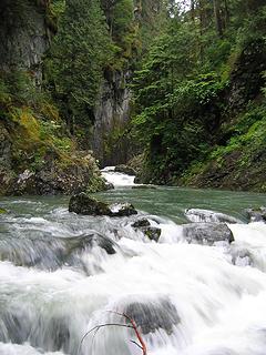 Looking upstream to large double ledge drop 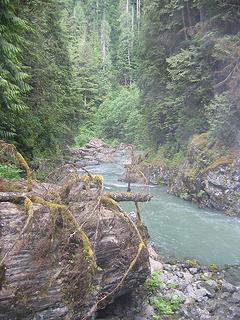 Above canyon exit rapid  Sultan River canyon
Any worthwhile expedition can be planned on the back of an envelope- H. W. Tilman
Any worthwhile expedition can be planned on the back of an envelope- H. W. Tilman
|
| Back to top |
|
|
Hulksmash
Cleaning up.

Joined: 20 Apr 2008
Posts: 7113 | TRs | Pics
Location: Arlington |
|
Hulksmash
Cleaning up.
|
Fri Jun 11, 2010 10:26 am |
|
|
"Bears couldn't care less about us....we smell bad and don't taste too good. Bugs on the other hand see us as vending machines." - WetDog
Albuterol! it's the 11th essential
|
| Back to top |
|
|
Quark
Niece of Alvy Moore

Joined: 15 May 2003
Posts: 14152 | TRs | Pics
|
|
Quark
Niece of Alvy Moore
|
Fri Jun 11, 2010 10:33 am |
|
|
That's a big-ass Doug Fir!  Cool to see yet another new trail going in - cooler to see these photos - definetely something to keep for future history buffs. There have been a few new trails built and/or finished in the last couple of years. Cool to see yet another new trail going in - cooler to see these photos - definetely something to keep for future history buffs. There have been a few new trails built and/or finished in the last couple of years.
"...Other than that, the post was more or less accurate."
Bernardo, NW Hikers' Bureau Chief of Reporting
"...Other than that, the post was more or less accurate."
Bernardo, NW Hikers' Bureau Chief of Reporting
|
| Back to top |
|
|
Slugman
Its a Slugfest!

Joined: 27 Mar 2003
Posts: 16874 | TRs | Pics
|
|
Slugman
Its a Slugfest!
|
Fri Jun 11, 2010 10:33 am |
|
|
Awesome information, thanks. It will be a nice little addition to our trail system at a time when it seems we lose trails but never gain any. So thanks for swimming against the tide.
|
| Back to top |
|
|
Backpacker Joe
Blind Hiker

Joined: 16 Dec 2001
Posts: 23956 | TRs | Pics
Location: Cle Elum |
Id like to see this on a map.
"If destruction be our lot we must ourselves be its author and finisher. As a nation of freemen we must live through all time or die by suicide."
Abraham Lincoln
"If destruction be our lot we must ourselves be its author and finisher. As a nation of freemen we must live through all time or die by suicide."
Abraham Lincoln
|
| Back to top |
|
|
GeoHiker
Rocky Walker
Joined: 26 Feb 2005
Posts: 6033 | TRs | Pics
Location: Off the Deep End |
|
GeoHiker
Rocky Walker
|
Fri Jun 11, 2010 3:52 pm |
|
|
Thanks SG for the wonderful report and pics. That's going to be a fine addition to our lowland hiking.
You call some place paradise, kiss it goodbye......Eagles
You call some place paradise, kiss it goodbye......Eagles
|
| Back to top |
|
|
Scrooge
Famous Grouse
Joined: 16 Dec 2001
Posts: 6966 | TRs | Pics
Location: wishful thinking |
|
Scrooge
Famous Grouse
|
Fri Jun 11, 2010 4:08 pm |
|
|
Thanks, Andy, this is definitely what's been running through my mind's eye.  That waterfall coming down the side is just a nice bonus.
And Sultan Guy said
That waterfall coming down the side is just a nice bonus.
And Sultan Guy said | Quote: | | Perhaps in the future we can develop a short river side trail to better access some more of this impressive canyon. |
Actually, I'd like to see one running all the way between the two dams. That's a dream I've had for years.
Something lost behind the ranges. Lost and waiting for you....... Go and find it. Go!
Something lost behind the ranges. Lost and waiting for you....... Go and find it. Go!
|
| Back to top |
|
|
Backpacker Joe
Blind Hiker
Joined: 16 Dec 2001
Posts: 23956 | TRs | Pics
Location: Cle Elum |
Sultan Guy, at the moment you cant even get to 6122. How far is this trail going to go down the river valley?
"If destruction be our lot we must ourselves be its author and finisher. As a nation of freemen we must live through all time or die by suicide."
Abraham Lincoln
"If destruction be our lot we must ourselves be its author and finisher. As a nation of freemen we must live through all time or die by suicide."
Abraham Lincoln
|
| Back to top |
|
|
Sultan Guy
Member
Joined: 22 Jul 2008
Posts: 353 | TRs | Pics
Location: Now reinforced with Concrete |
| Backpacker Joe wrote: | | Sultan Guy, at the moment you cant even get to 6122. How far is this trail going to go down the river valley? |
The PUD road from Olney Pass to USFS 6122 is open to the public. There is a new gate at the start of the 6122 road that has been open but is scheduled to be locked July 1st, when the mining season begins. This is where the new TH parking lot and restrooms will be built. Even with this gate locked it is perfectly legal and allowed to walk past this gate and anywhere you want in the canyon DOWNSTREAM of Culmback Dam.
The USFS did hand out copies of a modified USGS quad detailing the new proposed trail. I will ask for a digital copy and post it in this thread.
If you want to see this route just head up there and follow the flagging!
Any worthwhile expedition can be planned on the back of an envelope- H. W. Tilman
Any worthwhile expedition can be planned on the back of an envelope- H. W. Tilman
|
| Back to top |
|
|
Sultan Guy
Member
Joined: 22 Jul 2008
Posts: 353 | TRs | Pics
Location: Now reinforced with Concrete |
| Scrooge wrote: | | Actually, I'd like to see one running all the way between the two dams. That's a dream I've had for years. |
You will need to become a solid Class 4 whitewater kayaker as there are many sections with vertical cliff walls where locating a trail would be impossible. 
Any worthwhile expedition can be planned on the back of an envelope- H. W. Tilman
Any worthwhile expedition can be planned on the back of an envelope- H. W. Tilman
|
| Back to top |
|
|
Highwalker's Daughter
Member

Joined: 12 Aug 2006
Posts: 1575 | TRs | Pics
Location: Bothell, WA |
Thanks for the info - looking forward to hiking it in a couple of years.
|
| Back to top |
|
|
Sultan Guy
Member
Joined: 22 Jul 2008
Posts: 353 | TRs | Pics
Location: Now reinforced with Concrete |
Here is a map that shows the location of the new trail. This is from the USFS.
Any worthwhile expedition can be planned on the back of an envelope- H. W. Tilman
Any worthwhile expedition can be planned on the back of an envelope- H. W. Tilman
|
| Back to top |
|
|
aywolfpac
Member

Joined: 27 Jan 2008
Posts: 1286 | TRs | Pics
Location: Burlington, WA |
Anyone know what the status of this trail is today? I drove down there today but couldn't figure out where the trail started. I should've printed off that map ^ since it tells you exactly where it starts. I'll head in here sometime soon either way, but if the trail is completed that would be nice.
|
| Back to top |
|
|
|
|


 Like NOT building a tail on top of a beaver dam.
  Thanks for the update Andy.