| Previous :: Next Topic |
| Author |
Message |
Newt
Short Timer


Joined: 21 Dec 2001
Posts: 3176 | TRs | Pics
Location: Down the road and around the corner |
|
Newt
Short Timer
|
 Wed Jan 15, 2003 5:49 pm |
|
|
I've been farting around putting in a route with some waypoints for the PCT headed N from Stevens Pass to Lake Valhalla. I happened to put a waypoint in the second big gully at 47*,46',28"N, 121*,06',35"W NAD27.
When I ran a profile the waypoint showed up twice on the profile. It doesn't show up twice on the map. When zooming in to 200-400 I noticed a seam running E/W in the area of the ghost point location. This seam also is a stopping point when my screen refreshes from scrolling. The ghost is at a switchback at the beginning of Nason Creek which is right on the seam and is at 47*46'30"N, 121*06'34"W NAD27
I have deleted, got out, back in and placed new with a different name but same results. It's even listed twice on the profile. All CD's are loaded on HD.
I can't see the seam in DeLorme and the profile is good.
Anyone else experience this? What gives?
NN 
It's pretty safe to say that if we take all of man kinds accumulated knowledge, we still don't know everything. So, I hope you understand why I don't believe you know everything. But then again, maybe you do.
It's pretty safe to say that if we take all of man kinds accumulated knowledge, we still don't know everything. So, I hope you understand why I don't believe you know everything. But then again, maybe you do.
|
| Back to top |
  
|
|
-lol-
Member
Joined: 17 Dec 2001
Posts: 767 | TRs | Pics
|
|
-lol-
Member
|
Wed Jan 15, 2003 6:11 pm |
|
|
|
| Back to top |
|
|
-lol-
Member
Joined: 17 Dec 2001
Posts: 767 | TRs | Pics
|
|
-lol-
Member
|
Thu Jan 16, 2003 8:47 am |
|
|
|
| Back to top |
|
|
Mapman
Guest
|
|
Mapman
Guest
|
Thu Jan 16, 2003 1:00 pm |
|
|
Hey 2 door, Mal is talking about the digitized elevations. The graphics of the maps are different between the regional and state versions (regional a little better). But when you drag your mouse around, and the elevation displays on the bottom right, that's the digitized info he was referring to. Also the profiles are generated from this data.
|
| Back to top |

|
|
-lol-
Member
Joined: 17 Dec 2001
Posts: 767 | TRs | Pics
|
|
-lol-
Member
|
Thu Jan 16, 2003 1:30 pm |
|
|
|
| Back to top |
|
|
Newt
Short Timer
Joined: 21 Dec 2001
Posts: 3176 | TRs | Pics
Location: Down the road and around the corner |
|
Newt
Short Timer
|
Thu Jan 16, 2003 1:37 pm |
|
|
I don't understand.
When I snap to the points on the profile they have different coords and elevs.
When I place the curser over the 2 points on the map, they still show the same info as displayed on the profile.
If the elev info is generated from the DEM, then why would it display the ghost at a different coord and elev just on the profile?
The map is using the same DEM to produce the coords and elevs in both cases for the readout in LR corner.
Am I still missing something here?
This is on the State series.
[Edit]: Forgot to mention I tried picking different locations on the profile and my curser didn't jump around to different places on the route. My curser does move in tiny increments (01") on the profile tho. Doesn't do that on the map.
Getting loster
NN
It's pretty safe to say that if we take all of man kinds accumulated knowledge, we still don't know everything. So, I hope you understand why I don't believe you know everything. But then again, maybe you do.
It's pretty safe to say that if we take all of man kinds accumulated knowledge, we still don't know everything. So, I hope you understand why I don't believe you know everything. But then again, maybe you do.
|
| Back to top |
|
|
Tom
Admin

Joined: 15 Dec 2001
Posts: 17854 | TRs | Pics
|
|
Tom
Admin
|
Thu Jan 16, 2003 2:21 pm |
|
|
| Mapman wrote: | | Hey 2 door... |
Isn't it 2 doctor? 
|
| Back to top |
|
|
Newt
Short Timer
Joined: 21 Dec 2001
Posts: 3176 | TRs | Pics
Location: Down the road and around the corner |
|
Newt
Short Timer
|
Sun Jan 19, 2003 5:24 pm Regional Question
|
|
|
I have the state series and am wondering if there is really anything different or special that the regional series has that would be worth the purchase?
Thanks,
NN 
It's pretty safe to say that if we take all of man kinds accumulated knowledge, we still don't know everything. So, I hope you understand why I don't believe you know everything. But then again, maybe you do.
It's pretty safe to say that if we take all of man kinds accumulated knowledge, we still don't know everything. So, I hope you understand why I don't believe you know everything. But then again, maybe you do.
|
| Back to top |
|
|
Tom
Admin
Joined: 15 Dec 2001
Posts: 17854 | TRs | Pics
|
|
Tom
Admin
|
Sun Jan 19, 2003 6:16 pm |
|
|
From what I gather, the regional series are higher resolution. The downsides seem to be no gps support (without an upgrade), no overlap at the edges, and no coverage outside the mountains.
|
| Back to top |
|
|
-lol-
Member
Joined: 17 Dec 2001
Posts: 767 | TRs | Pics
|
|
-lol-
Member
|
Sun Jan 19, 2003 7:59 pm |
|
|
|
| Back to top |
|
|
Newt
Short Timer
Joined: 21 Dec 2001
Posts: 3176 | TRs | Pics
Location: Down the road and around the corner |
|
Newt
Short Timer
|
Sun Jan 19, 2003 8:52 pm |
|
|
Thanks guys. Do also get a better print quality?
Thanks,
NN
It's pretty safe to say that if we take all of man kinds accumulated knowledge, we still don't know everything. So, I hope you understand why I don't believe you know everything. But then again, maybe you do.
It's pretty safe to say that if we take all of man kinds accumulated knowledge, we still don't know everything. So, I hope you understand why I don't believe you know everything. But then again, maybe you do.
|
| Back to top |
|
|
-lol-
Member
Joined: 17 Dec 2001
Posts: 767 | TRs | Pics
|
|
-lol-
Member
|
Sun Jan 19, 2003 9:26 pm |
|
|
|
| Back to top |
|
|
Tom
Admin
Joined: 15 Dec 2001
Posts: 17854 | TRs | Pics
|
|
Tom
Admin
|
Sun Jan 19, 2003 9:45 pm |
|
|
For comparison, here's 3D Topo Quads at full resolution. Sorry, but it just trounces both Topo! State & Regional.  I have the state edition of Topo! and knew it had pretty poor resolution but didn't realize the regional edition of Topo! wasn't even full resolution. I have the state edition of Topo! and knew it had pretty poor resolution but didn't realize the regional edition of Topo! wasn't even full resolution.  I'm glad I didn't waste my money on it. Just goes to what I've been saying that while the 3D Topo Quads scans aren't as "pretty" as Topo! they certainly are much higher quality. I find I generally use Topo! when I want to do a quick and dirty lookup (yeah the interface is better) but for "serious" trip planning I opt for 3D Topo Quads. I'm glad I didn't waste my money on it. Just goes to what I've been saying that while the 3D Topo Quads scans aren't as "pretty" as Topo! they certainly are much higher quality. I find I generally use Topo! when I want to do a quick and dirty lookup (yeah the interface is better) but for "serious" trip planning I opt for 3D Topo Quads.
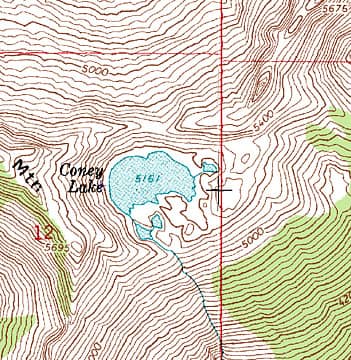 Compare To 3D Topo Quads
|
| Back to top |
|
|
Tom
Admin
Joined: 15 Dec 2001
Posts: 17854 | TRs | Pics
|
|
Tom
Admin
|
Sun Jan 19, 2003 11:10 pm |
|
|
Once I found the map I was looking for, downloaded a 4 MB zip file  , unzipped it, then discovered it wasn't the map I was looking for , unzipped it, then discovered it wasn't the map I was looking for  , then downloaded another 3 MB zip file, unzipped it, opened this file, found the section I was looking for, I don't see any gain in resolution over the 3D Topo Quads crop. I'd upload it but it's the exact same picture. , then downloaded another 3 MB zip file, unzipped it, opened this file, found the section I was looking for, I don't see any gain in resolution over the 3D Topo Quads crop. I'd upload it but it's the exact same picture.  If free is important, and time and sanity are too, my choice would be terraserver. You can tweak terraserver to get any size you want (if you know what you're doing), plus you can span different quads and get the satellite shots as a bonus.
|
| Back to top |
|
|
Tom
Admin
Joined: 15 Dec 2001
Posts: 17854 | TRs | Pics
|
|
Tom
Admin
|
Mon Jan 20, 2003 1:20 am |
|
|
For example, here is the normal terrraserver link. This is the medium size for the sake of illustration (since I can't link directly to the large size) but even the large size may not get you as large a picture as you'd want to view or print.  However, all is not lost.
1) Click on the download link and then right click on that image to get this link.
2) From there you can play with the X and Y parameters to make it as wide or tall as you want.
3) Finally, just change the T parameter in the link to a 1 and voila, you have the corresponding satellite shot available for download. However, all is not lost.
1) Click on the download link and then right click on that image to get this link.
2) From there you can play with the X and Y parameters to make it as wide or tall as you want.
3) Finally, just change the T parameter in the link to a 1 and voila, you have the corresponding satellite shot available for download.
|
| Back to top |
|
|
|
|


